

New Mexico map
Gallup map
About 20,339 people live here (Census Bureau, 2024 estimate). The sheet's index lists 300 streets; West Aztec Avenue, Nizhoni Boulevard and Roundhouse Lane cross the most grid squares. Also on it: Fox Run Golf Course (Gallup), Red Rock Park and Gallup Service Unit.
Open the map (PDF, US Letter)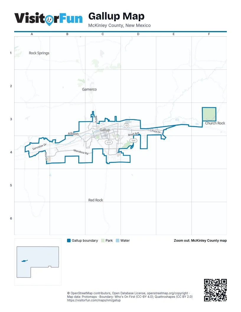
Street index of Gallup
Each street on the sheet and the grid squares it crosses.
- South 2nd StreetC3, C4
- West Aztec AvenueC3, B4, C4
- South Boardman DriveD3, D4
- Munoz DriveC3, C4
- West Maloney AvenueC3
- Joseph M Montoya BoulevardC3
- South 3rd StreetC3, C4
- Boardman AvenueC4
- West Logan AvenueC3, C4
- Ford DriveC3
- Arnold StreetC3, C4
- Miyamura OverpassC3
- East Aztec AvenueC3, D3
- Mendoza RoadB4, C4
- Nizhoni BoulevardA4, B4, C4
- South Country Club DriveC3, C4
- North 9th StreetC3
- Church Rock StreetD3, E3
- Rico StreetA4
- Park AvenueC4
- Rollie RoadB4
- Aztec AvenueD3
- Ridgecrest AvenueC4, D4
- Susan AvenueC4, D4
- South Ford DriveC3
- Philipin AvenueC4
- Redrock DriveC4
- Helena DriveC4
- College DriveC4
- Armand Ortega BoulevardB4
- East Buena Vista AvenueC3
- Henrietta DriveC3, C4
- Apache CircleC4
- Tocito TrailD3
- Rehoboth DriveE3
- Maloney AvenueB3, C3
- Ciniza DriveD3, E3
- West Jefferson AvenueC3
- East Green AvenueC3
- Stagecoach RoadC4
- South Puerco DriveC3, C4
- Allison RoadB3, B4
- Vanden Bosch ParkwayE3, E4
- South 4th StreetC3, C4
- West Lincoln AvenueC3
- New Mexico State Highway 566F3
- Marguerite StreetB4
- West Green AvenueC3, C4
- Dani DriveC4
- Toltec DriveE3
- South 8th StreetC3, C4
- South 5th StreetC3, C4
- Twin Buttes RoadA4
- Freedom DriveC4
- Red Rock Park main access roadF3
- South Clark StreetC4
- Jefferson AvenueC3
- Coal Basin RoadC3
- Acoma StreetB3
- Roundhouse LaneC3, B4, C4
- Hasler Valley RoadC3, D3
- Sanostee DriveA4
- Patton DriveD3, D4
- Milda AvenueC4, D4
- Boyd AvenueD3, D4
- West Coal AvenueC3
- East Wilson AvenueC3
- Industry DriveA4, B4
- East Mesa AvenueC3
- Mariyana StreetC4
- East Logan AvenueC3
- East Hill AvenueC3
- South Strong DriveC3, C4
- Burke DriveC3, C4
- Kachina StreetB3, C3
- South Grandview DriveC3, C4
- Arizona StreetB4
- D and S Trailer Ranch RoadB4
- Padre Canyon RoadF3
- Mark AvenueD3
- 11th StreetC3, C4
- South Woodrow AvenueC3, C4
- Mentmore RoadA4
- Cliff DriveC4
- North 6th StreetC3
- Wilson AvenueC3
- Linda DriveC4
- Mc Kee DriveD3, D4
- Verdi StreetD3
- Baker StreetC4
- East Pershing AvenueC3
- East Maloney AvenueC3
- East Coal AvenueC3
- South 6th StreetC3, C4
- Red Rock Park campground loop roadF3
- Blue Hill AvenueA4
- Dee Ann AvenueC4
- Grandview DriveC4
- Zecca DriveD3, D4
- West Hill AvenueC3
- West Mesa AvenueC3, C4
- Zia DriveD3, E3
- Barbara AvenueB4, C4
- Plateau DriveD4
- Red Rock DriveC4
- West Princeton AvenueC3
- East Adams AvenueC3
- Cactus RoadC4
- Valentina DriveD3
- Western Skies RoadB4
- Warehouse LaneC3, B4, C4
- West Morgan AvenueC4
- Canoncito AvenueC4
- Julie DriveD3, D4
- Chee Dodge BoulevardA4
- Kit Carson DriveC4
- Caesar DriveC3, D3, D4
- Jay StreetD3, D4
- Elva DriveC4
- Chaco DriveD3, E3
- West Chee Dodge BoulevardA4
- South 1st StreetC3
- Williams StreetD3
- Arena RoadA4
- Dairy DriveD4
- East Morgan AvenueC3
- South 7th StreetC3, C4
- South Navajo DriveC3
- North Strong DriveC3
- Viro CircleC4
- Grey Hill CircleA4
- Monterey DriveC4
- Basilio DriveD3
- Gurley AvenueC4
- Grenko Nine RoadB4
- Boggio DriveD3, D4
- North 2nd StreetC3
- North 3rd StreetC3
- Gomez DriveC3
- South McKinley DriveC3
- Rimrock DriveD4
- Lewann DriveD4
- Old Zuni RoadC4
- West Victoria AvenueC3
- Kevin DriveD4
- Klagetoh StreetA4
- Maya DriveE3
- La Cima RoadC4
- North 1st StreetC3
- Peggy Ann DriveC4
- South Florence StreetB4
- Challenger RoadF3
- Clay StreetD3
- Rancho RoadC4, D4
- Cll PinonC4
- Day StreetA4, B4
- East Princeton AvenueC3
- Mountain View DriveC4
- North 5th StreetC3
- Wyatt StreetC4
- South Cipriano StreetC4
- Vo-Tech DriveC4
- Low Mountain StreetA4
- Metro AvenueC3
- Lincoln Elementary School DrC3, C4
- East Jefferson AvenueC3
- Kiva DriveC4
- Camino del Campo CirculoA4
- Chamisal AvenueD3
- South Cliff DriveC3
- Bortot DriveD3
- Sunset DriveC3
- Water Tower RoadE4
- Elizabeth StreetD3
- Parmelee StreetC4
- Martinelli DriveD3, D4
- Coyote Canyon LaneD3
- Calvin Hall DriveC4, D4
- North 4th StreetC3
- Rudy DriveC4
- North Cliff DriveC3
- Saguaro DriveA4, B4
- Valley View DriveC3, D3
- Box Canyon AvenueA4
- West Wilson AvenueC3
- Western Skies LoopB4
- Coyote Canyon DriveD3
- North McKinley DriveC3
- Camino de Monte SolA4
- National Cemetery RoadD3
- Mossman AvenueD3
- Mallica DriveD3
- Tafoya DriveC3, C4
- North Carver StreetC3
- Tanner AvenueC4
- Mesquite DriveC4
- Hazel DriveD4
- Alto DriveD4
- Radosevich AvenueD3
- Edith AvenueC4
- Dusty RoadC4
- Cam Del SolC4
- Marguerite Franco DriveC3
- Hospital DriveC4
- Strong DriveC4
- Rupe RoadC4
- Defiance AvenueC4
- Diamond CircleD4
- Hamilton RoadC3
- East Vega AvenueC3
- Bataan Veterans StreetC3
- Sherry LaneB3
- Boulder DriveC4
- South 9th StreetC3, C4
- Escalante RoadC4
- Manuelito AvenueA4
- Sunde StreetC4
- Manor DriveD4
- Mazon AvenueD4
- West Adams AvenueC3
- West Maxwell AvenueC3
- Kestrel LaneC3
- Jeff King StreetA4
- Sandstone DriveD4
- Arnold DriveC4
- Baca CourtD3
- Barnett LaneD3
- Piano AvenueD3
- Belle DriveD3, D4
- Linda Vista RoadC3, D3
- North 10th StreetC3
- Miss Lisa LaneD4
- Debra DriveC4
- Wade CircleD3
- Mine Run StreetD3
- West Gold AvenueC4
- Pinon LaneC4
- Dellago DriveC3
- North High StreetC3
- Placida DriveC4
- East Pine AvenueC4
- Pueblo CourtA4, B4
- Cerrito DriveC4
- Lookout AvenueD4
- Morello AvenueC3
- North 11th StreetC3
- College AvenueC4
- South Bradley StreetC3, C4
- Telstar RoadF3
- Buena VistaC4
- Hemlock Canyon TrailD3
- Wagon RoadC4
- Boulder RoadC4
- Country Club PlaceC4
- Yei AvenueC4, D4
- East Cedar AvenueC4
- Curtis AvenueC3
- Elison StreetC4
- West Copper AvenueC4
- Red Hill DriveD3
- North Puerco DriveC3
- Rob-Roy StreetA4
- East AztecD3
- Cedar Hills DriveC4
- Hanson DriveC4
- Western LaneB4
- Sophie AvenueC4
- Cindy LaneD3, E3
- Elm CircleC4
- Gallup Central High School DrB4
- North 7th StreetC3
- Lion Hall DriveC4
- Fairway DriveC3, D3
- Ignacio DriveC4
- Foothills AvenueD4
- Starkovich LaneC3
- Anthony AvenueD4
- Vista AvenueC3
- Monterey CourtC4, D4
- Gallup McKinley Middle School DrC4
- Lance StreetC4
- Maple AvenueC4
- Canyon AvenueA4
- Todd DriveD4
- 7th StreetC4
- East Lincoln AvenueC3
- Sierra DriveC4
- Sagebrush LaneC4
- Sweetwater PlaceA4
- Lopez PlaceC4
- Alto PlaceD4
- Susan CircleD4
- Canyon de Chelly LaneD3
- Gladden AvenueD3
- Ortega StreetC4
- South Dean StreetC4
- Cam RancheroC4
- Mc Devitt PlaceD4
- Bonito CourtE3
- Plaza AvenueA4
Places on the map
- Albertsons
- Americas Best Value Inn
- Angelo DiPaolo Memorial Stadium
- AutoZone
- Aztec Auto Sales
- Aztec Plaza
- Babe Ruth Park
- Bowling Shipping Center
- Bud Light
- Burger King
- Cash Cow Homestore
- Cedar Hills Plaza
- Chief Theater
- Children's Library
- City Electric Shoe Shop
- CP East Gallup
- CP West Gallup
- Del Norte Elementary School
- El Mercado Plaza
- Fox Run Golf Course (Gallup)
- Gallup City Cemetery
- Gallup Indian Medical Center
- Gallup Service Unit
- Hillcrest Cemetery
- Hozho Academy
- Love's Travel Stop
- Octavia Fellin Public Library
- ONE9 Travel Center
- Red Rock Park
- Red Rock Park campground
- Rio West Mall
- Stagecoach Elementary School
- The UPS Store
- Trade Mart Square
- United States Postal Service
- USA RV Park
- Walmart Supercenter
- Zecca Plaza
Next to Gallup
- Allison
- Church Rock
- Gamerco
- Red Rock
- Rock Springs / Chéchʼízhí
© OpenStreetMap contributors, Open Database License, openstreetmap.org/copyright · Map data: Protomaps · Boundary: Who's On First (CC-BY 4.0); Quattroshapes (CC BY 2.0)















