

New Mexico map
Lincoln County map
About 20,025 people live here (Census Bureau, 2024 estimate). The sheet's index lists 300 streets; County Road B007, County Road B001 and Pipeline Road cross the most grid squares. Things to do inside the boundary: Ruidoso.
Open the map (PDF, US Letter)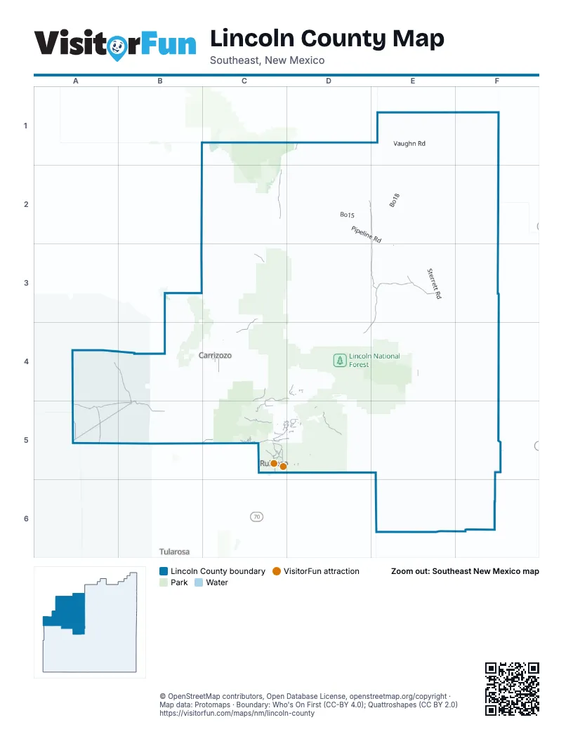
Street index of Lincoln County
Each street on the sheet and the grid squares it crosses.
- Mechem DriveC5
- Sudderth DriveC5, D5
- Central AvenueC4, D5
- E AvenueC4
- Main StreetD1
- West 2nd StreetD4, F5
- Lincoln AvenueD4
- Smokey Bear BoulevardD4
- Ski Run RoadC5
- Gavilan Canyon RoadC5, D5
- FS 107C5
- Airport RoadC5, D5
- Carrizo Canyon RoadC5
- Bonito Lake RoadC5
- Hull RoadC5
- Paradise Canyon DriveC5
- Country Club DriveC5
- Grindstone Canyon RoadC5
- Cree Meadows DriveC5
- Old Fort Stanton RoadD5
- Mescalero TrailC5
- NM 247 - NM 42F2
- County Road B007D2, E2, E3, D4, E4
- White Sands Missile Range P Route 9A4, B4, A5, B5
- White Sands Missile Range P Route 12A5, B5
- County Road B010E3
- County Road A032C2
- County Road A044C3, C4
- Wsmr P Rt 8A5
- County Road E009D5
- Main RoadD4, C5
- Wsmr P Rt 9A5, B5
- Wsmr P Rt 7A5
- Ranch RoadE3
- Cora Dutton RoadC4, D4, C5
- Sandesta DriveC5, D5
- Nogal Canyon RoadC4
- County Road A003B5
- High Mesa DriveC5, D5
- Forest Service Road 131C5
- Water Canyon RoadC4
- Three Rivers RoadB5, C5
- Airport StreetC4
- Santiago DriveD5
- Mesa Barn RoadC4, C5
- Cedar Creek DriveC5
- High MesaC5
- CR E009D5
- Las EstrelasD5
- Wsmr P Route 12A5
- Santiago CircleD5
- Sonterra DriveC5, D5
- Center RoadD4
- Juniper SpringC5
- White Mountain DriveC5
- Hill Country Road / Hill CountryD5
- Fort Stanton RoadC5, D5
- Cimarron TrailC5, D5
- 14th StreetC4
- E044E4
- Altamira DriveC5, D5
- 5th StreetC4, C5
- Resort DriveC5
- Warrior DriveC5
- White Sands Missile Range P Route 8B5
- County Road C015C4, C5
- Center DriveD4, C5
- Meander DriveC5
- Rio FelixD5
- Jack Little DriveC5
- County Road 002C5, D5
- Morgan DriveC5
- WSMR P Route 7A5
- Pinon DriveC5
- County Road D004C5
- High Mesa RoadC5, D5
- Pinon RoadC5
- Fort StantonC5
- Lucille DriveC5
- Yard RoadD4
- Esconida DriveD5
- Reservoir DriveD5
- D StreetC5
- Heights DriveD5
- Eagle DriveC5
- North StreetC5
- Indian Service Rt 21C5
- County Road B001D2, E2, D3, E3, D4
- Vaughn RoadE1, E2
- Pipeline RoadC1, C2, D2, E2, E3
- County Road 037E4, F4, F5
- County Road B020E2, E3, E4, F4
- Ancho White Oaks RoadC3
- County A019C1, C2
- County Road E028E5, E6
- County Road E034F5
- County Road E030E6
- County Road B026F3, F4
- Sterrett RoadE3
- County Road A022C1, C2
- County Road A023C1, C2
- Hale Lake RoadD5
- Vaughn Loop RoadE3
- County Road B048F1, F2
- Bo15D2
- County Road A 036D2, D3
- County Road E024D5, E5
- White Oaks RoadC3, D3, D4, C5
- Capitan Gap RoadD4
- County Road A 020C2
- Pipe Line RoadE3, F3
- County Road A017C2, C3
- White Sands Missile Range S Route 337A4, B4
- County Road B014E2, E3
- White Sands Missile Range P Route 11B4, B5
- Salazar Canyon RoadD4, E4, E5
- County Road A036C2, D2, C3, D3
- County Road C001D4
- Valle del SolC4
- County Road A035C2, C3
- County Road 22D4, D5
- East Mesa TrailD5
- County Road A038C3, D3
- Chupadera Mesa RoadB3, C3
- County Road B029F4
- County Road A014C2, C3
- Seven Cabins RoadE4
- County Road B019E2
- White Sands Missile Range S Route 313B5
- Cloudcroft Admin Site RoadD4
- Koprian Canyon RoadD4
- Mcdaniel RoadB3
- West Mountain RoadD4
- Fort Stanton North TrailD5
- Coyote Canyon RoadC3
- County Road AO20B2, C2
- KatrinaC1
- Bo18E2
- County Road A 010C4
- County Road A 032C2
- Boy Scout RoadE4
- County Road E038E5
- County Road A033D2
- County Road East 33F5
- Hickson Tank RoadC3, D3
- White Sands Missile Range S Route 335B4
- County Road E039E4, E5
- Gas Pipeline RoadC2
- County Road B021F2
- Katrina RoadC1, D1
- Dean DriveD4
- County Road C008C4
- Big Tank CanyonD4, D5
- County Bo08E3
- County Road A040D4
- Fs 976EC3
- E035F4, F5
- County Road B012E3
- Red Cloud RoadC1
- Fo20E2
- Sunrise DriveC5, D5
- Wsmr S Rt 336B4
- Wsmr P Route 73A4, A5
- County Road B009E3
- Copper Ridge RoadC5, D5
- Valley View RoadD4, D5
- USFS Road 57E4
- Wsmr P Route 9A4
- Wsmr South Route 332A4
- County Road E023E5
- Fs 9023GC3
- County Road B025E3
- County Road C0002D4, D5
- Monjeau Lookout RoadC5
- County Road East 028E5, E6
- Rainmaker RoadD5
- T West RoadD2, E3
- Basin StreetC4
- County Road A013C3
- Co E036F4, F5
- Eagle Creek Canyon RoadC5, D5
- County Road C007D4
- County Road A010C4, D4
- County Road A012B3
- County Road E006D5
- A036C3
- County Road B031E4
- Canyon RoadD4, C5, D5
- Peralta Pass RoadC4, D4
- Whistler TrailC4
- Bonito LoopD5
- Deer Park DriveC5
- County Road A002B5
- County Road E008D5
- Eagle Lodge RoadC5
- Crown DriveC5
- County Road A 015C3
- County Road B003D4
- Gopher Gulch LoopC4
- Saddle Ridge RoadC4
- Little Creek RoadC5, D5
- Ranney Ranch RoadD2
- Brady Canyon RoadC5
- White Mountain Meadows DriveC5
- South Base RoadD4
- Longhorn LoopC4
- Wsmr P Route 11B4
- County Road A011C4
- C0 Rd A034C2, D2
- Eo44E4
- Corrida de RioC5, D5
- County Road 035F5
- Bonito Creek CampgroundD5
- Alpine Village RoadC5
- Los Chozas TrailE5
- Forest Road 119D5
- Via Rio BonitoD5
- County Road 24C5, D5
- County Road A041C3, C4
- Pino RoadC4
- 18th StreetC4
- Spencer DriveD5
- Mount Capitan RoadD4
- County Road B028E3
- Fs 9023AC3
- Long RoadD4
- Shelerville RoadC4
- Little Big Horn RoadD5
- Juniper RoadC5, D5
- Paso Monte RoadC5, D5
- County Road B027F3
- Antelope TrailC5
- C R A005C4
- 2nd StreetC4, C5, D5
- McDanial LaneD5
- Saddlebrook RoadD5
- County Road E031E6
- County Road A019C1
- County Road C017D1
- Valley View DriveD4, C5, D5
- County Road C012C4
- Sierra Blanca DriveC5
- County Road E035F5
- Excalibur RoadC5
- County Road E040E4
- Convair DriveC5
- Antler DriveC5, D5
- Shadow Mountain Ranch RoadC4
- Warwick DriveC5
- Saddle Gate RoadC4
- O Bar O RoadC4
- Indigo LoopC4
- Homestead CircleC5
- McBride DriveC5
- Homestake Lode RoadC4
- Chupadera Mesa Spur RoadB3, C3
- Cedar Creek RoadC5
- County Road B002D4
- Deer Creek RoadC5
- Co A036C3
- Copper Canyon RoadC5
- County Road B004D4
- 585BD5
- Guenevere AvenueC5
- Musket Ball DriveC5
- Spring Canyon RoadC5
- Little Creek Hills RoadD5
- Fr 482C3
- Fs 483C3
- Camino AlegroC5
- Deer Valley DriveC5, D5
- B AvenueC4
- Fs 443D5
- Lupus DriveC5
- Frontage RoadD5
- County Road E016E5
- Tucson Trail RoadD4
- Chance LoopC5
- StableC5
- County Road A028C1
- County Road E019E5
- Scenic DriveC5
- Rio Bonito DriveD5
- High Loop DriveC5
- Midiron DriveC5
- Camelot DriveC5
- Goodnight Loving TrailD5
- Willie Horton DriveC5
- Falcon DriveC5, D5
- C R 165D4
- Snowcap DriveC5
- A033D2
- Jose Vega LoopC4
- B015D2
- Scenic LoopC5
- Fs 976AC3
- West LoopC4
- F SouthD4
- Fs 502E5
- Pichado Placitas DriveC5
Things to do on the Lincoln County map
Places on the map
- 70 West Plaza Shopping Center
- All American Park
- Alto Lakes Golf & Country Club
- Alto Reservoir
- Bonito Lake
- Capitan
- Capitan Mountains Wilderness
- Carrizozo
- Carrizozo Lava Flow Wilderness Study Area
- Carrizozo Municipal Airport
- Corona
- Cree Meadows Country Club
- Fitness Trail
- Fort Stanton
- Fort Stanton-Snowy River National Conservation Area
- Grindstone Lake
- Grindstone Mesa Loop Trail
- Hull Loop
- Kokopelli Country Club
- Lincoln National Forest
- Little Black Peak Wilderness Study Area
- Lower Cedar Creek Trail
- Moon Mountain Majesty Trail
- Moon Mountain Recreation Area
- North Lake
- Rio Bonito Trail
- Ruidoso
- Ruidoso Downs
- Ruidoso Downs Race Track
- Ruidoso High School
- Sierra Blanca Regional Airport
- South Fork Campground
- The Golf Club at Rainmakers
- The Links at Sierra Blanca
- The Outlaw at Alto Lakes
- Three Rivers Campground
- Valle Del Sol Golf Course
- Valley of Fires Campground
- Valley of Fires Recreation Area
- White Mountain Wilderness
Next to Lincoln County
- Tularosa
© OpenStreetMap contributors, Open Database License, openstreetmap.org/copyright · Map data: Protomaps · Boundary: Who's On First (CC-BY 4.0); Quattroshapes (CC BY 2.0)















