

New Mexico map
Los Lunas map
About 19,907 people live here (Census Bureau, 2024 estimate). The sheet's index lists 300 streets; Huning Ranch Loop, State Road 6 and Main Street Southwest cross the most grid squares. Also on it: El Cerro de Los Lunas Preserve, El Cerro de Los Lunas and Brad Francis Ford.
Open the map (PDF, US Letter)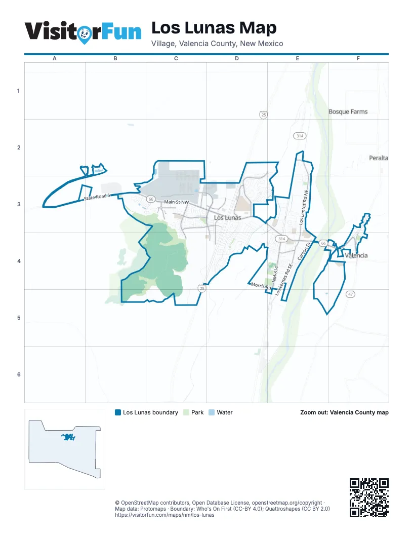
Street index of Los Lunas
Each street on the sheet and the grid squares it crosses.
- Main Street NorthwestC3, D3
- State Road 6A3, B3, C3
- Main Street SouthwestD3, E3, E4
- Main StreetE4, F4
- Main Street NortheastE4
- Highway 47F4
- LambroseF4
- Los CerritosD2, E2, D3
- NM-314E3, E4, E5
- Emilio Lopez RoadD3
- El Cerro RoadF4
- Huning Ranch LoopC3, D3, C4, D4
- Los Morros RoadC3, D3
- Los Lentes Road NortheastE2, E3, E4
- Lonestar StreetC3, D3
- Sundance Street SouthwestC3, D3
- Los Lentes Road SoutheastE4, E5
- Sun Ranch Village RoadD3, D4
- Jubilee BoulevardC3
- Courthouse RoadE4
- Sand Sage Road NorthwestC3
- Desert Willow RoadD3
- Palmilla Road NorthwestD3
- Red River Road SouthwestC3
- Promenade TrailC3
- Griegos RoadE2
- Red River RoadC3
- NM-314 NE4
- Camelot Boulevard SouthwestD3, D4
- Access Road SouthwestC4, D4, C5
- Carson DriveE4
- Highline Road NorthwestD3
- Canal Boulevard SouthwestD3, D4
- Messenger Loop NorthwestC3
- Morris RoadD4, E4, E5
- Lower Levee Road NorthwestC2, B3, C3
- Juan Perea RoadE4
- Valley View DriveD4
- Tessoro Loop NorthwestD2, D3, E3
- Coronado StreetE4
- Fire Wheel AvenueD3, D4
- Big Sky AvenueC3
- Clear Sky StreetC3
- Grant BoulevardD3, D4
- Abby Street SouthwestB3, C3
- Grasslands RoadD3
- Emily Avenue SouthwestC3
- Camino RusticaD4
- Parkview DriveD4
- Rio Chama CircleC3
- Crestview DriveD4
- Carrizo Street NorthwestD3
- Cortez Street SoutheastE4
- Camino del Rey DriveD3, D4
- Carnival Avenue NorthwestD3, E3
- Valle Vista Road NorthwestD3
- Tondre RoadE3
- Manzano Peak Street SouthwestB3, C3
- Blaylock LaneE3
- Sierra Vista Avenue SouthwestB3
- Blue Sage AvenueC3
- Trujillo StreetE3
- Dennis Northeast DriveE3
- Calle Don DemetrioE3
- Mesa LoopD3
- Camino RinconD4
- Sun Valley RoadF4
- Zuni River CircleC3
- Vallecito Loop NorthwestD2, E2
- Fire Wheel RoadD3
- Luna Avenue SoutheastE4
- Cerro Crestado DriveD3
- Sun Ranch LoopD3
- Camino CoronaD4
- Camino CancunD4
- Southwest Sichler RoadE3, E4
- Long Bow LoopD3
- Rio Grande Boulevard SouthwestD3
- Tierra Verde Loop NorthwestD3
- Montara DriveD3
- Adela LaneD3
- Purple Sage Road NorthwestD3
- Valle De Colores Street NorthwestD2, D3
- Hillside DriveD4
- Sandoval Road SouthwestE3, E4
- Wagon Wheel StreetC3
- Colibri AvenueD3
- Valle Grande Drive SouthwestE4
- Edeal RoadE4, F4
- Don Diego StreetE4
- Taylor RoadE3
- Creekside AvenueC3
- Desert Sienna AvenueC3
- Drake RoadD4
- Pinzon RoadD3
- Appaloosa DriveF3, F4
- Capitan Street NorthwestD3
- Primrose AvenueD3
- Coplen RoadD4
- Sichler RoadD4, E4
- Chamisa AvenueE4, E5
- Vista Grande RoadC3
- Don Pasqual RoadE3
- Camino CanteraD4
- Vista Larga Drive SouthwestE4
- Camino CanyonD4
- Pandora Drive SoutheastD4
- Redondo CourtD3
- Avenida EsplendidaD3
- Calle Don SantiagoE3
- Monte Vista RoadE3
- Heaton LoopE4, E5
- Campfire StreetC3
- Osha Spring Street SouthwestB3
- Las Rosas DriveE4
- Vista De Bosque RoadC3, C4
- Camino del Rey Drive SouthwestD3, D4
- Bosque Vista LoopD3
- Lujan RoadF4
- Las FloresD4, E4
- Prairie Ridge StreetC3
- Broadview LoopD3
- Santa Fe TrailC3
- Rain Lily StreetC3
- Purple Ester AvenueC3
- Desert Sage AvenueC3
- Capital DriveD3, D4
- Teles StreetE4
- Wagon Trail StreetD3, D4
- Breech DriveD3, D4
- Colonial Avenue SouthwestE4
- Socorro DriveD3, D4
- Cerro Vista LoopD3
- Black Hat AvenueC3
- Guadalupe Peak Street SouthwestB3, C3
- Castillo StreetE4
- Verde DriveE4
- Key Haynes Drive SouthwestD3
- Gallahad StreetD3, D4
- Prairie Sage StreetC3
- Alto Colores Street NorthwestD2, D3
- Calle de OrtizD4
- Mesa Ridge Drive SouthwestD4
- Lopez Road SoutheastE4
- Mesa CruzadaD3
- Luna Hill AvenueE4
- Calle Consuelo NortheastE3
- Little WingsD3
- Village DriveE4
- Garden Avenue SouthwestE4
- Ladron AvenueE4
- Solitude StreetC3
- Crownover RoadE3
- Juniper AvenueE4, E5
- Manzano AvenueE4
- Vallejos LaneE3, E4
- La Cueva Street SouthwestB3
- Ted BacaE4
- Orange Blossom StreetF4
- GrasslandsD3
- Open Range AvenueC3
- Vista Centro DriveD4
- Pecos BoulevardD4
- Park Lane SouthwestE4
- Mission AvenueE4
- Emilio Lopez LoopD3
- Otero StreetE4
- Camino CuliacanD4
- Michael Avenue SouthwestB3, C3
- Lonetree StreetC3
- Chisolm TrailC3
- Villa Contesa Loop NorthwestD2, D3
- North Sky Ranch RoadC5
- Angel Loop SouthwestD3
- Festival Road NorthwestD3
- Northeast Los Lentes RoadE2
- Tiger LaneD3
- Golden Gate Drive SouthwestD3
- Fernandez StreetE4
- Casa del Sol LaneE3
- Cinder LaneE3
- Lucero RoadE4
- Pine StreetF4
- Chavez LaneD3, E3
- Ash DriveD4
- Calle de Las Familias CourtE3
- Rivas RoadE3
- Entrada DriveD3, D4
- Diana DriveE4
- Boot Hill LoopC3
- Camino Real SouthwestE4
- Gerald Chavez LaneE3
- Vista Hill North LoopD4
- Sun Mesa StreetC3
- WatsonE3
- Charles StreetE4
- Soledad DriveD3
- Gene StreetE4
- Lam Court SouthwestC3
- Lancelot StreetD3, D4
- Corta CanteraD4
- Avenida Las Vistas NorthwestD3
- Penny LaneD4
- Vialpando StreetE4
- Stover RoadF3
- Vista De Rio RoadC3
- Gensen Drive SouthwestE4
- Wittwer Court NorthwestE3
- Camino de HiginioE2
- Ellen StreetE3
- Applewood LaneD4
- Behnke RoadE3
- Roberts CircleF3
- Alegria Road NorthwestD3, E3
- Avenida Serena NorthwestD3
- Schmidt PlaceE4
- Wyatt Avenue SouthwestB3, C3
- Don Carlos StreetE3, E4
- Blanca AvenueD3
- Avenida Pastoral NorthwestD3
- Willow RoadE2
- Adeline Avenue SouthwestB3, C3
- Blaylock PlaceE2, E3
- Rainsage CourtC3
- Crimson Clover RoadD3
- Cloud View AvenueC3
- Vista Hill West LoopD4
- Sunset View StreetD3
- Calle Don MarcosE3
- Romero StreetE4
- Adobe LaneE3
- Findley Street SouthwestB3
- Mountain Laurel RoadF4
- Avenida Las VistasD3
- High Plains StreetC3
- Osha Peak Street SouthwestB3, C3
- Scarlet Sage RoadD3
- Cactus DriveF4
- Castillo DriveD3, D4
- Gallegos RoadE4
- Maverick StreetD3
- Pheasant LaneD4
- Panada DriveD4
- Gomez DriveD4
- Panda DriveD4
- Audrey Avenue SouthwestB3
- Amistad RoadE4
- Ralliere RoadF3
- Sidewinder StreetD4
- Pecos River SouthwestC3
- Apache Plume DriveE5
- Onesimo Fajardo LaneE3
- Balok RoadE3
- Maestas Drive SouthwestD3, D4
- Recreo Road NorthwestD3, E3
- Desert Flower AvenueE5
- Carrasco LaneE3
- Stagecoach StreetD3
- Luna StreetE4
- Calle ConsueloE3
- Orchard PlaceE4
- Gonzales Lane SoutheastE4
- Sagebrush DriveD4
- Santa Fe StreetE4
- Capila Peak Avenue SouthwestB3
- Helen CircleE4
- Pioneer Trail NorthwestB3
- Vallecito Court NorthwestD2
- Vista DriveE4
- Archuleta CourtE4
- Blue Bonnet DriveF4
- Mountain View LaneE4
- Tome Hill AvenueE4
- Aspen DriveE4
- Senor Santos Lane SotuheastF4
- Stetson StreetC3
- Cypress CourtE4
- Grace Street SouthwestB3, C3
- Spruce CourtE4
- Vista Manzano RoadC4
- Merlot LaneF3
- Needle Avenue SouthwestB3
- Panoan Drive SouthwestD4
- Valle Vista CT NWD3
- Rosie G Otero RoadE4
- Aragon CourtE4
- Chablis Lane NortheastF3
- Longhorn StreetD3, D4
- Olympia CircleE3
- Piedra Lisa Avenue SouthwestB3
- Vista El Cerro RoadC3
- Calle Adelaida NortheastE3
- Capulin Peak Avenue SouthwestB3
- Chafey Drive South WestC3
- Juan Perea Road SoutheastE4
- Corta CoronaD4
- John John DriveE4
- Los NardosE4
- Hernandez Street South WestC3
- Mills RoadE2
Places on the map
- 13th Judicial District Court
- 2 Minute Warning
- Aaron's
- Albertsons
- Aliberto's
- Allsup's
- Alon
- Applebee's
- Asahi
- AutoZone
- Bank of Albuquerque
- Bank of the West
- Bella Vida
- Big O Tires
- BLVD Automotive
- Brad Francis Ford
- Buffalo Wild Wings
- Burger King
- Calvery Chapen New Harvest
- Car Wash Village
- Century High School
- Daniel Fernandez Memorial Park
- El Cerro de Los Lunas
- El Cerro de Los Lunas Preserve
- Enchantment Little League
- Heritage Park
- Huning Ranch Park
- Los Lunas Elementary School
- Los Lunas High School
- Los Lunas Middle School
- Los Lunas Sports Complex
- Northern Summit
- San Clemente Catholic Church
- Sundance Elementary School
- The UPS Store
- Tillery Buick GMC
- Valencia County Administration
- Valencia Y
- Valley View Park
- Walmart Supercenter
Next to Los Lunas
- Bosque Farms
- Peralta
© OpenStreetMap contributors, Open Database License, openstreetmap.org/copyright · Map data: Protomaps · Boundary: Who's On First (CC-BY 4.0); Quattroshapes (CC BY 2.0)















