

Nevada map
Boulder City map
About 15,029 people live here (Census Bureau, 2024 estimate). The sheet's index lists 300 streets; Veterans Memorial Highway, Boulder City Bypass and Veterans Drive cross the most grid squares. Things to do inside the boundary: Blazin Paddles, Lake Mead Cruises and Las Vegas Boat Harbor.
Open the map (PDF, US Letter)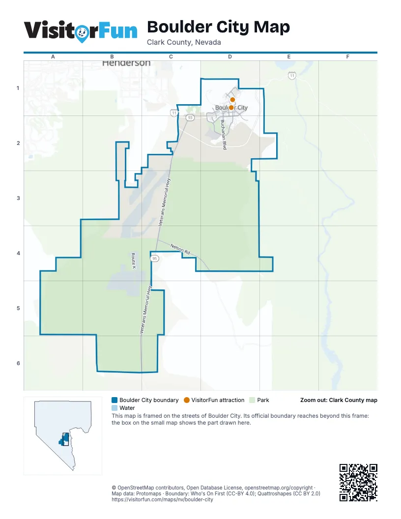
Street index of Boulder City
Each street on the sheet and the grid squares it crosses.
- Boulder City BypassD1, E1, C2, D2
- Boulder City ParkwayD1, C2, D2
- Veterans Memorial HighwayC2, C3, C4, B5, C5, B6, C6
- Veterans Memorial DriveD1, D2
- Adams BoulevardD1, D2
- Buchanan BoulevardD1, D2
- Nevada WayD1
- Utah StreetD1, D2
- Wyoming StreetD1
- Nelson RoadC4, D4
- Georgia AvenueD2
- Avenue ID1
- Yucca StreetD1, D2
- Marina DriveD1
- Industrial RoadD1
- Canyon RoadD1
- Avenue GD1, D2
- 5th StreetD1
- Avenue BD1, D2
- Lake Mountain DriveD1
- Colorado StreetD1
- Ville DriveD1
- Elm StreetD1
- Gingerwood StreetD2
- Pacifica WayD1
- River Mountain AvenueD1
- Judi LaneD1
- Isabel DriveD1
- Bootleg Canyon RoadD1
- Route KB4
- Veterans DriveC1, D1, C2, D2
- San Felipe DriveD2
- Red Mountain Access RoadD1
- Arizona StreetD1
- Canyon Point RoadD2
- Quail DriveD2
- Sandra DriveD2
- Quartzite RoadD1
- Impact SandC2
- Fairway DriveD2
- Keys DriveD1
- New Mexico StreetD1
- Marita DriveD2
- Avenue KD1, D2
- Bristlecone DriveD2
- California AvenueD1
- Darlene WayD2
- Silver Line RoadC2
- 6th StreetD1
- Foothill DriveD1
- Cascata DriveC1, C2
- Bermuda DunesD2
- Del Prado DriveD1
- Christina DriveD2
- Otono DriveD1
- Red Rock RoadD1
- Black Hills DriveC2
- Railroad Museum RoadD1
- Pueblo DriveD2
- Valencia DriveD1
- El Camino WayD2
- Paloma DriveD1
- Capri DriveD2
- Northridge DriveD1
- Bronco RoadD1
- Lakeview DriveD1
- Temple Rock RoadD1
- Sunrise CircleD2
- 8th StreetD1
- Villa Grande WayD1
- 7th StreetD1
- Mancha DriveD2
- Roger Ray RoadC2
- Healing LoopD1
- Avenue MD1
- Denver StreetD1
- Jeri LaneD2
- Malaga DriveD1
- Avenue AD1
- Shirley LaneD2
- Pebble Beach DriveD2
- Irene DriveD2
- Birch StreetD1
- Arrayo WayD1
- Cottonwood StreetD1, D2
- Wells RoadD1
- Woodacre DriveD1
- Robin WayD1
- Broadmoor CircleD2
- Boy Scout Canyon RoadD2
- Hermosa LaneD1
- Robinson LaneD1
- Park StreetD1
- Stone Canyon RoadD1
- Bighorn DriveD1
- Gloria LaneD2
- Mendota DriveD2
- Alpine DriveD1
- Dorothy DriveD2
- Aspen DriveD2
- Endora WayD1
- Highland DriveD2
- Date StreetD1
- Bluebird DriveD1
- Pelican WayD1
- Don Vincente DriveD1
- San Remo WayD2
- Lynn DriveD2
- Hotel PlazaD1
- Fleetwood StreetD2
- Avenue LD1
- Esther DriveD2
- Canary WayD1
- Avenue HD1
- Hazelwood StreetD2
- Granada DriveD1
- Lake Superior LaneD1
- Corral RoadD2
- Mount Antero WayD1
- Walnut DriveD1, D2
- Cattail Falls StreetD2
- Red Mountain DriveD2
- Mount Hunter WayD1
- Renaissance StreetD1
- 3rd StreetD1
- Cats Eye DriveD1
- Ash StreetD1
- Gingerwood ParkwayD2
- Teakwood StreetD2
- Valley View LaneD1
- Monterey DriveD2
- Royal Birkdale DriveD2
- Stacey LaneD2
- Cherry StreetD1
- Sandpiper WayD1
- Forest LaneD1
- Fire Agate DriveD1
- Ridge RoadD1
- Coronado DriveD2
- Vaquero DriveD2
- Medical Park DriveD2
- Bryce Canyon StreetD2
- Grillo WayD1
- Claremont StreetD1
- Potosi StreetD2
- Appaloosa RoadD1
- Shoshone WayD1
- Lake Huron LaneD1
- Montera LaneD2
- Lake Michigan LaneD1
- Oriole WayD1
- Olmo WayD1
- Aztec PlaceD1
- Pinehurst DriveD1
- Shenandoah StreetD2
- Avenue DD1
- Vincent LaneD1
- Avenue FD1
- Vista Lago WayD1
- Mount Bona WayD1
- Hillside DriveD1
- Blue Lake DriveD1
- Avenue CD1
- Cindertree LaneD1
- Boulder Landing LaneD1
- Ironwood StreetD2
- Lime Rock RoadD1
- Pinto RoadD1
- Railroad AvenueD1
- Hilton Head DriveD2
- Rawhide RoadD1
- Kelpwood StreetD2
- Nadine WayD2
- Indian Wells DriveD2
- Sorrel RoadD1
- Mariposa WayD1
- Washburn StreetD2
- Lake Havasu LaneD1
- Palmero WayD2
- Del Rey DriveD1
- Dreamcatcher DriveD1, D2
- Lynnwood StreetD2
- Mount Tamalpais WayD1
- Tamarisk LaneD1
- Elsa WayD2
- Los Tavis WayD2
- Kendall LaneD1
- Marwood StreetD2
- Cummings DriveD1
- Morgyn LaneD1
- Palmwood StreetD2
- Sequoa StreetD2
- Tamarack DriveD1
- Lake Hill DriveD1
- 2nd StreetD1
- Becky LaneD2
- Chestnut LaneD1
- Lodge RoadD1
- Lido DriveD1
- Ramona LaneD2
- Freedom LaneD1
- 1st StreetD1
- Florence DriveD1
- Mount Williamson WayD1
- Yosemite StreetD2
- Wilson CircleD1
- Key Largo DriveD1
- Sherri LaneD2
- Greenway LaneD1
- Lake Erie LaneD1
- Jasper WayD1
- Bayview DriveD1
- Mount Elbert WayD1
- Saint Jude's StreetD1
- Providence LaneD2
- Slate Mountain DriveD2
- Legacy DriveD2
- Da Vinci CoveD1
- Mount Ranier WayD1
- Reese PlaceD1
- 9th StreetD1
- Arapaho WayD1
- Dianne DriveD2
- Aaron WayD1
- Del Sol DriveD1, D2
- Paiute DriveD1
- Laurel DriveD1
- Mount Blackburn LaneD1
- Park PlaceD1
- Azul WayD1
- Garrett LaneD1
- Tuscany CourtD1
- Armada PlaceD1
- Hopi PlaceD1
- Valley DriveD1
- Brentwood DriveD2
- Lake Ontario LaneD1
- Greenbriar PlaceD1
- Yates LaneD1
- Boulder City SpeedwayD2
- Del Monte LaneD2
- Garnet PlaceD2
- Renaissance CourtD1
- Sindelar CircleD1
- Fir StreetD1
- Sparrow WayD1
- Casa Montana WayD1
- Del Rio WayD2
- Fuente WayD1
- Paul C Fisher WayD2
- Industrial CourtD1
- Moonstone DriveD1
- Redwood StreetD2
- Robert C. Mendenhall Scenic OverlookD1
- Judi PlaceD1
- Don Vincente CourtD1
- Madrone StreetD1, D2
- School DriveD1
- Saddle LaneD1
- Joshua StreetD1
- Turquoise CourtD1
- Juniper WayD1
- Radig CourtD2
- Clarice LaneD1
- Tara CourtD1
- Benita PlaceD1, D2
- Mustang RoadD1
- Newport WayD1
- Della CourtD2
- Lake Merritt LaneD1
- Cottonwood CoveD1
- Milton CourtD1
- Carlsbad StreetD2
- Comanche WayD1
- Navajo DriveD1
- Tuscany CoveD1
- Tall Trees StreetD2
- Clubhouse DriveD2
- Great Sands StreetD2
- Saint Andrews CourtD2
- Bryant CourtD1
- Kaelyn StreetD1
- Cheryl LaneD1
- Sunset PointD1
- Kendrick PlaceD1
- Laguna LaneD1
- Seville WayD1
- Cedar DriveD2
- Donner WayD1
- Hallett Cove CourtD1
- Lake Winnebago LaneD1
- Spring Canyon RoadC2
- Webster WayD2
- Lorryn LaneD1
- Cayuga CourtD1
- Woodcrest DriveD1
- Malaga CourtD1
- Mead WayD1
- Briarstone DriveD2
- Caria CourtD2
Things to do on the Boulder City map
Places on the map
- 7-Eleven
- Adams Boulevard Community Park
- Albertsons
- Andrew J Mitchell Elementary School
- ARCO
- Best Western Hoover Dam Hotel
- Bighorn Park
- Black Mountain
- Black Mountain Overlook
- Boot Leg Canyon Pit
- Bootleg Canyon Park
- Boulder City Conservation Easement
- Boulder City High School
- Boulder City Historic District
- Boulder City Hospital
- Boulder City Municipal Airport
- Boulder City Municipal Golf Course
- Boulder City Speedway
- Boulder Creek Golf Course
- Boulder Oaks RV Resort
- Boulder Rifle & Pistol Club
- Canyon Trail RV Park
- Cascata Golf Course
- Eldorado Dry Lake
- Eldorado Valley
- Elton M. Junior High School
- Flood Control Basin
- Inner Caldera
- Nevada State Railroad Museum Boulder City
- Nevada State Veterans Home
- Nevada Welcome Center
- Pilot Cone
- Red Mountain
- Saint Andrew Catholic Church
- Southern Nevada Veterans Memorial Cemetery
- The Knoll
- The UPS Store
- Veterans Memorial Drive Trail
- Veterans' Memorial Park
Next to Boulder City
© OpenStreetMap contributors, Open Database License, openstreetmap.org/copyright · Map data: Protomaps · Boundary: Who's On First (CC-BY 4.0); Quattroshapes (CC BY 2.0)















