

Nevada map
Carson City map
About 58,148 people live here (Census Bureau, 2024 estimate). The sheet's index lists 300 streets; Brunswick Canyon Road, Carl Howell Freeway and Patrick Daily Memorial Highway cross the most grid squares. Things to do inside the boundary: Hang Gliding Tahoe, Bodines Casino and Visit Carson City Visitors Center.
Open the map (PDF, US Letter)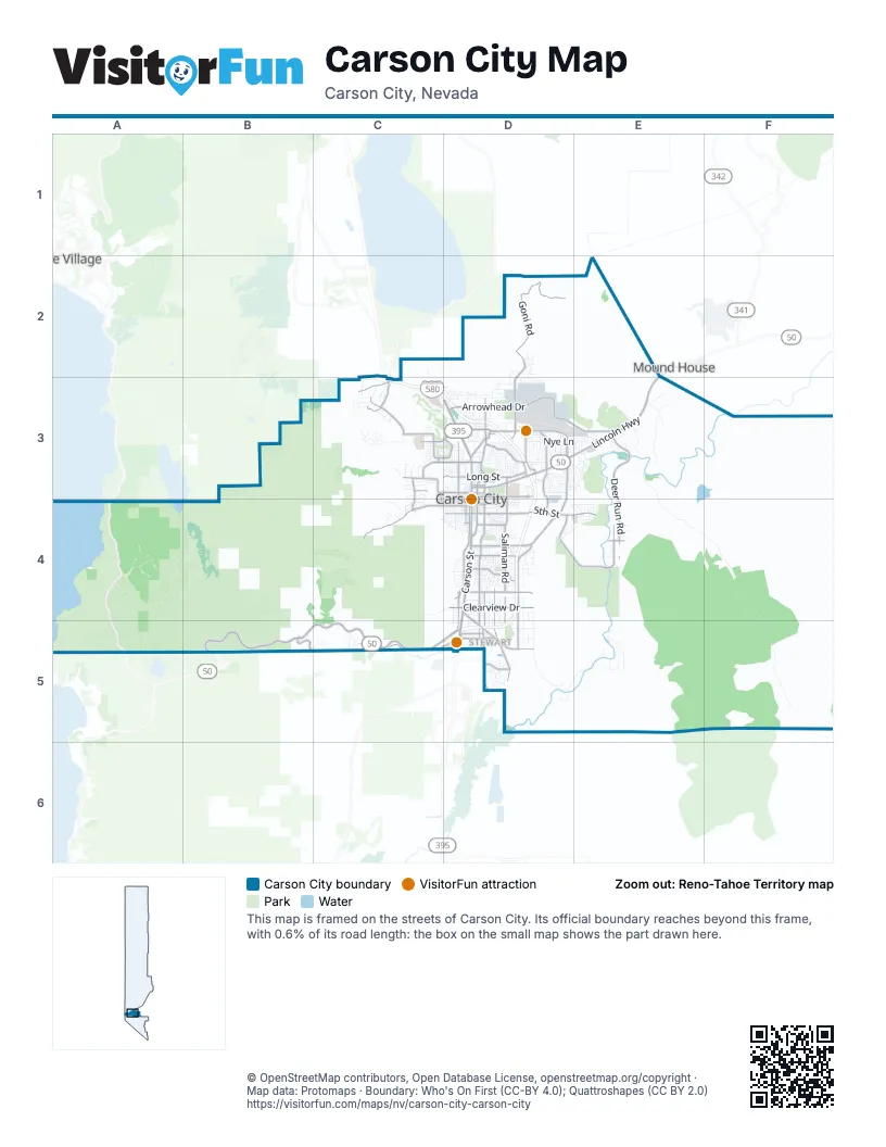
Street index of Carson City
Each street on the sheet and the grid squares it crosses.
- Carl Howell FreewayC3, D3, D4
- Carson City FreewayD4, D5
- Patrick Daily Memorial HighwayB5, C5, D5
- South Carson StreetD4, D5
- Lincoln HighwayE2, D3, E3
- North Carson StreetD3, D4
- East William StreetD3
- Snyder AvenueD4, D5
- Fairview DriveD3, D4
- East Arrowhead DriveD3, E3
- East 5th StreetD4, E4
- East College ParkwayD3
- West College ParkwayC3, D3
- South Saliman RoadD4
- North Roop StreetD3, D4
- South Stewart StreetD4
- North Stewart StreetD3, D4
- North Saliman RoadD3, D4
- West Arrowhead DriveD3
- Arrowhead DriveD3
- Bowers Mansion RoadC3
- Goni RoadD2, D3
- South Edmonds DriveD4, D5
- Bigelow DriveD4, D5
- North Deer Run RoadE3, E4
- Airport RoadD3, D4
- Kings Canyon RoadC4
- Carson River RoadD4, E4
- Koontz LaneD4
- South Curry StreetD4
- Combs Canyon RoadC3
- East Clearview DriveD4
- Silver Sage DriveD4, D5
- Old Clear Creek RoadC5, D5
- North Mountain StreetD3, D4
- Center DriveD4, D5
- East Robinson StreetD3
- North Ormsby BoulevardC3, C4
- Northridge DriveD3
- South Roop StreetD4
- East Long StreetD3
- Sonoma StreetD4
- North Lompa LaneD3
- Pinion Hills DriveE4
- Colorado StreetD4
- West Winnie LaneC3, D3
- West Washington StreetC3, D3
- Lakeview RoadC3
- South Deer Run RoadE4
- Hobart RoadC3
- Ash Canyon RoadC3
- Clear Creek AvenueD5
- Oak Ridge DriveC3, D3
- Longview WayC3, C4
- Golf Club DriveB5
- West King StreetC4, D4
- Emerson DriveD3
- Hillview DriveD4, D5
- Cochise StreetD4, D5
- Hot Springs RoadD3
- West Long StreetD3
- Little LaneD4
- Race Track RoadD5
- West 5th StreetD4
- East Musser StreetD4
- Arthur StreetD5
- Retail DriveD3
- South Division StreetD4
- Laurel RoadE4
- Russell WayD3
- West Clearview DriveD4
- East Washington StreetD3
- North Winnie LaneC3
- East John StreetD3
- Curry StreetD4
- Wa-Pai-Shone AvenueD5
- East Winnie LaneD3
- Lupin DriveD5
- West 10th StreetD4
- Silver Sage CircleD4
- Vista Grande BoulevardD5
- Vista Grand BoulevardD5
- Brunswick Canyon RoadE3, E4, F4, F5
- Sierra Vista LaneE4, E5
- Golden Eagle LaneD5, E5
- Voltaire Canyon RoadC4, D4
- Morgan Mill RoadE3
- East Nye LaneD3, E3
- Conte DriveD4, D5
- Conestoga DriveC3, D3
- Gentry LaneD4, D5
- Timberline DriveC3
- Medical ParkwayC3, D3
- Rifle Range RoadE3
- Imus RoadC2, C3, D3
- Sherman LaneD3, E3
- Northgate LaneD3
- North Division StreetD3, D4
- Meadow Wood RoadC3
- East Appion WayD4
- North Nevada StreetD3, D4
- Centennial Park DriveE3
- Perimeter RoadD3
- Ponderosa DriveD4, D5
- South Sutro TerraceD3
- Baker DriveD4
- Hells Bells RoadD4, E4
- Ruby LaneD3
- Valley View DriveD4
- Buzzys Ranch RoadD4, E4
- East Telegraph StreetD4
- Bennett AvenueD5
- Empire Ranch RoadE3
- East Roland StreetD5
- Woodside DriveD3
- Silver Oak DriveC3, D3
- East Bonanza DriveD3
- Gregg StreetE3
- Beverly DriveD3
- Flint RoadE3
- North Curry StreetD3, D4
- Robert Hill RoadC5
- Marsh RoadE4
- Salk RoadD2, D3
- Carriage Crest DriveD3
- Dori WayD3
- Junction DriveC5, D5
- Damon RoadD4
- Sussex PlaceC4
- Numaga Pass RoadC3
- Muldoon StreetD4, D5
- Carmine StreetD3
- East Overland StreetD4
- Kingsley LaneD4
- Bunch WayD3
- Lake Glen DriveD4
- Royal DriveD3
- Crain StreetD4
- Thompson StreetD4
- Old Hot Springs RoadD3
- Molly DriveD3
- North Fall StreetD3, D4
- Manhattan DriveC3
- Water Tank RoadC4
- Table Rock DriveD3
- Rio Vista LaneE5
- Marian AvenueD3
- Corbett StreetD3
- Imperial WayD3
- Camille DriveD3
- Spooner DriveD3
- South Nevada StreetD4
- West 4th StreetD4
- Weise RoadC3
- Stafford WayD4
- County Line RoadC3
- California StreetD4, D5
- Desatoya DriveD3
- Parkland AvenueD4
- Windridge DriveD3
- North Edmonds DriveD3
- Rabe WayD5
- Matterhorn LaneD3
- North Richmond AvenueD3, D4
- Hamilton AvenueD3
- Shady Tree LaneD3
- Vicky LaneD5
- East Roventini WayD4
- West Robinson StreetD3
- Eagle Valley Ranch RoadC3
- Broadleaf LaneD3
- South Lompa LaneD4
- Jefferson DriveD3
- Northview DriveD4
- Poole WayD3
- Research WayD3
- Convair DriveD3
- Industrial Park DriveD4
- Boeing WayD3
- Butti WayD3
- Heritage WayE3
- National Forest Development Road 210C5
- North Minnesota StreetD3, D4
- West Telegraph StreetD4
- West Nye LaneD3
- Waterford PlaceC3, C4
- West Musser StreetD4
- Kelvin RoadD3
- Lockheed WayD3
- Apollo DriveD3, E3
- Mark WayD3
- Sheep DriveE3
- Siskiyou DriveD3
- Voltaire StreetD4, D5
- Oak StreetD4, D5
- Centennial DriveE3
- Manzanita TerraceD3
- Walker DriveD3
- Wagon Wheel RoadC3
- Monte Rosa DriveD3
- Tule Peak CircleD5
- Tiger DriveD3
- Bath StreetD3
- Divot RoadE3
- North Valley StreetD3, D4
- Ash Canyon AccessC3
- Boyle StreetD4
- Stanford DriveD3
- Heidi CircleD4, D5
- South Minnesota StreetD4
- Gold Strike LaneC5
- Jeanell DriveD3
- Coventry DriveC4
- Sagewood Manor ApartmentD3
- Christmas Tree DriveC3
- Mayflower WayD3
- Copper Mountain DriveD5
- Chaparral DriveC3, D3
- Pinebrook DriveD4
- La Loma DriveD3
- Sneddon WayD3
- Market StreetD3
- Seely LoopD3
- Snowflake DriveC3
- North Sutro TerraceD3
- Westwood DriveC3
- West Bonanza DriveD3
- Schulz WayD5
- Rhodes StreetD4
- Pat LaneD4
- Slide Mountain DriveD3
- Levi Gulch RoadC3
- Monroe AvenueD3
- Ladera DriveD3
- North Plaza StreetD3, D4
- Rand AvenueD3
- East 2nd StreetD4
- Jacobsen WayD5
- South Richmond AvenueD4
- Gibson AvenueD5
- Mountain Park DriveD3
- Lindsay LaneD3
- Lepire DriveD3, E3
- Palo Verde DriveD3
- Evergreen DriveC3
- Gold Leaf LaneD3
- Flintwood DriveC3, D3
- Gold Hill DriveD3
- Brown StreetD3
- Paradise ViewC3
- Hickory DriveD4, D5
- Lahontan DriveD5
- Eagle Station LaneD4
- Mono LaneD4
- Gordon StreetD3, E3
- Sunrise DriveE3
- Pioche StreetD4
- East Adams StreetD3
- Michael DriveD3
- Kit Sierra WayD3
- Gordonia DriveD3
- Louise DriveD3
- Brush DriveC3
- Cortez StreetD4
- Terrace StreetD4
- Woodcrest LaneD4
- West Sunset WayD3
- Quail LaneE4
- Meadowbrook LaneD4
- Tahoe DriveD3
- Reds GradeC3
- Bryce DriveD3
- Elm StreetD4
- Garnet WayD3
- Rolling Hills DriveD3
- Quinn DriveD3, E3
- Goldfield AvenueD4
- Duck Hill RoadC2
- Pilot Peak DriveD3, D4
- Wellington WestC3
- Eastgate Siding RoadE3
- Halleck DriveD4
- Frontier DriveE3
- Canyon DriveC4
- Adaline StreetD3
- Spartan AvenueD4
- Thames LaneC3, C4
- Oregon StreetD4
- Fleischmann WayD3
- West Spear StreetD3, D4
- East Park StreetD3
- Karin DriveD3
- North Walsh StreetD3, D4
- Hobbyhorse LaneD5
- East Proctor StreetD4
- Livermore LaneD5
- Armory LaneD4
- Kitchen DriveD4
- Prospect DriveC3
- Newman PlaceC3
Things to do on the Carson City map
Places on the map
- 3590 N Carson Street, Carson City NV
- Ambrose Ranch Natural Area
- C Hill
- Capital Ford
- Capitol Complex
- Carson City Landfill
- Carson City Library
- Carson City Post Office
- Carson Colony
- Carson High School
- Carson Mall Shopping Center
- Carson Middle School
- Carson River Park
- Carson RV Resort
- Carson Tahoe Regional Medical Center
- Carson Tahoe Self Storage
- Centennial Park
- Centennial Peak
- Crack'in Lake
- Crack'in Lake Overlook
- Eagle Valley Golf Course
- Empire Ranch Golf Course
- Fremont Elementary School
- Fuji Park & Fairgrounds
- Fulstone Wetlands
- Governors Field
- Greenbelt Park
- Hohl RV Sales
- Mills Park
- Moffat Open Space Property
- Nevada State Prison
- Northern Nevada Correctional Center
- Northwest Carson City
- Pete Livermore Sports Complex
- Prison Hill Recreation Area
- Riverview Park
- Silver Oak Golf
- Silver Saddle Ranch
- Washoe Ranches
- Washoe Tribe of Nevada and California
Next to Carson City
- Incline Village
- Mound House
© OpenStreetMap contributors, Open Database License, openstreetmap.org/copyright · Map data: Protomaps · Boundary: Who's On First (CC-BY 4.0); Quattroshapes (CC BY 2.0)















