

Pennsylvania map
Blair County map
About 120,269 people live here (Census Bureau, 2024 estimate). The sheet's index lists 300 streets; Walnut Street, William Penn Highway and Grandview Road cross the most grid squares. Things to do inside the boundary: Logan Valley Mall.
Open the map (PDF, US Letter)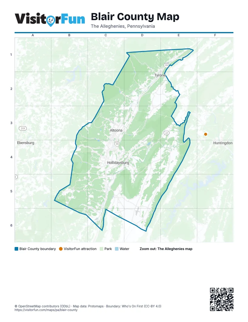
Maps inside Blair County
1 map inside, from the street map of Blair County down.
Street index of Blair County
Each street on the sheet and the grid squares it crosses.
- William Penn HighwayD3, E3, B4, C4, D4
- East Pleasant Valley BoulevardD2, C3, D3
- Dunnings HighwayC4, C5, C6
- Old Route 22B4, C4, D4
- Woodbury PikeC5, C6
- South Eagle Valley RoadE1
- 6th AvenueC3, C4
- Charger HighwayC4, C5
- Frankstown RoadC4, D4
- Old 6th Avenue RoadD2, C3, D3
- 4th AvenueC3, C4
- Colonel Drake HighwayC3
- 17th StreetC3, C4
- 3rd AvenueC3, C4
- Bedford StreetC4, C5, C6
- Logan BoulevardC4
- South Logan BoulevardC4
- Birmingham PikeE2
- Park AvenueD2, C4, C5
- Washington AvenueD2, C3, C4
- 7th AvenueC3, C4
- Pleasant Valley BoulevardC3, C4
- Broad AvenueC3, C4
- Beale AvenueC3, C4
- Sproul Mountain RoadC6
- Union AvenueC3, C4
- Sabbath Rest RoadD3
- West Plank RoadC4
- 18th StreetC3
- Tyrone PikeE1
- 11th StreetC3, C4
- Valley View BoulevardC3
- Plank RoadC4
- Blair StreetD2, C4, D5
- North 4th AvenueC3
- North Logan BoulevardC3, C4
- Allegheny StreetC3, C4
- East Walton AvenueC3, D3
- 10th AvenueC3
- Old US Highway 220C5
- North 8th StreetD2, C3
- Penn StreetC4, D5
- Chestnut AvenueC3
- I-99 AccessE1
- East Chestnut AvenueC3
- Broad StreetC4
- 8th StreetD2, C3, C4
- 12th AvenueC3
- Pennsylvania AvenueE1, D2, E2
- 7th StreetD2, C3
- Lloyd StreetC3
- South Kettle StreetC3
- Greenwood RoadC3, D3
- 6th Avenue RoadC3
- West 10th StreetD2
- South Juniata StreetC4
- Pottsgrove RoadD3
- South Lloyd StreetC3
- Bellwood AvenueC3
- East 6th AvenueC3
- East 10th StreetD2, E2
- Dummings HighwayC4
- Rutgers LaneD3
- East Plank RoadC4
- East 11th StreetD2, E2
- William Penn RoadC6
- Piney Creek RoadD4, E4, D5
- Johnstown RoadB5, C5
- Scotch Valley RoadD3, C4, D4
- Reservoir RoadC4, D4, C5
- Janesville PikeD1, D2
- Cove Mountain RoadC5, D5, D6
- Grandview RoadC2, D2, C3, D3
- Veterans Memorial HighwayB3, C3
- Juniata Gap RoadC3
- Skelp Mountain RoadD2
- West Loop RoadD4, D5
- Tuckahoe RoadC2, D2
- Yellow Spring DriveE3, E4
- Mill Run RoadC3
- Juniata River RoadD4, E4
- Carson Valley RoadC4
- Bloomfield RoadC5, C6
- Skyline DriveC3, C4
- Newry LaneC4
- Tunnelhill StreetB4
- 3rd StreetD2, C3, C4
- 58th StreetC4
- Loop RoadC4, D4
- Convention Center BoulevardC4
- Warriors Mark PathE1
- East Main StreetD2, C5
- Veterans Memorial HigwayC3, C4
- Osgood DriveC4
- Adams AvenueD1, E1, D2, C3
- Back Vail RoadE1
- Main StreetE1, D2, C5
- Wopsy RoadC3
- North Juniata StreetC3, C4
- 24th StreetC3
- Municipal DriveC4
- North Tuckahoe StreetC2, D2
- Lincoln AvenueD1, E1, D2, C4
- 31st StreetC3, C4
- PA 866D6
- Clay AvenueD1, D2
- High StreetC4, E4
- Curryville RoadD6
- Colonial DriveC4
- Ponderosa DriveC3
- West 15th StreetD2, E2
- Ridge AvenueC4, D4
- Good LaneC4
- South Market StreetD5, D6
- 40th StreetC4
- Orchard AvenueC4
- Columbia AvenueD1, D2
- Spang StreetC5
- West Allegheny StreetD5
- Pennington RoadE2
- West 1st StreetE4
- SR PA 866D6
- East Wopsononock AvenueC3
- Canal StreetC4, E4
- West 14th StreetD2, E2, C4
- Amelia AvenueC4
- Newry StreetC4
- East Allegheny StreetD5
- North Market StreetD5
- Logging Road 11035B3
- East Logan StreetD2
- Bellwood RoadD2
- West 20th StreetD1
- Greyson DriveC4
- Bloomfield StreetC5
- Arlaryd StreetC4
- South Montgomery StreetC4
- Rhode Island AvenueC4
- West Main StreetC5
- Forest StreetD2, B4
- Plank StreetC4
- Puritan RoadB5
- Kettle RoadD2, E2, C3, D3
- Clover Creek RoadE4, D5, E5
- Tipton RoadD1, D2
- Henrietta RoadD6
- Sugar Run RoadB4, C4
- Mill RoadC4, C5, C6
- Fox Run RoadE3, E4
- Locke Mountain RoadD4
- Poplar Run RoadB5, C5
- Quarry RoadD2, E2, D4, C6
- Polecat RoadB5, C5
- Cove Lane RoadC5, D6
- Cross Cove RoadC6, D6
- Knob Run RoadB5, C5
- Turkey Valley RoadD4
- Covedale RoadE4
- Plum Creek RoadC5
- Beaver Dam RoadD3, D4
- Ski Gap RoadB5, C5, C6
- Brush Mountain RoadD2, D3, C4, D4
- Bell Tip RoadD2
- Maple Hollow RoadC4
- Buttermilk Hollow RoadC5, B6, C6
- Knob RoadB5
- Valley Forge RoadC4, C5
- Hileman RoadD2, E2
- Riggles Gap RoadC2, C3, D3
- River RoadD2, C4, D4
- Golf Course RoadD2, D3
- Puzzletown RoadC5
- Lock Mountain RoadD5
- Silver Barn RoadE2
- Auction RoadD6
- Diamond LaneB5
- Davis RoadC3, D5
- 8th AvenueC3, C4
- Spruce StreetD2, C4, C5, C6
- Oak AvenueC3, C4
- Tel Power RoadD4
- Millerstown RoadD5, D6
- Foot of Ten RoadC4
- 13th StreetC3, C4
- 4th StreetD2, C3
- Locust Hollow RoadB5, B6
- 12th StreetC3, C4
- 9th AvenueC3
- Lower Claar RoadB6, C6
- Avalon RoadC3
- Chimney Rocks RoadC4
- Lower Riggles Gap RoadC3, D3
- West Chestnut AvenueC3, C4
- Sylvan DriveC4
- 19th StreetC3
- Royer Mountain RoadD4
- Walnut AvenueC3, C4
- Cross Roads LaneD6
- Ruskin DriveC4
- North 5th StreetD2, C3
- Burns AvenueC4
- Upper Clover Creek RoadE4
- Beaver StreetC4
- Sandy Run RoadC3, D3
- 25th AvenueC3
- Sylvan Heights DriveC4
- Sandbank RoadD3
- Union StreetC4, E4
- Catfish RoadC5
- Freedom StreetC5
- 22nd StreetC3
- Bear Wallow RoadC4
- Gwin RoadC3
- 11th AvenueC3
- Spang Street ExtensionC5
- BroadwayC3
- Hixton RoadC4
- State Route 2005D5, D6
- California AvenueC4, C5
- Monastery RoadC5
- Forsht DriveC4
- Elm StreetC3, C4
- Closson RoadC5
- Harmony DriveC4
- South 13th StreetC3
- Howard AvenueC3
- Fairway DriveC4
- Kuhn LaneC4
- Sierra DriveC4
- Burgoon RoadC4
- Bristol LaneC4
- East 25th AvenueC3
- Pemberton RoadE2
- Wehnwood RoadC3
- Wopsononock AvenueC3
- Race StreetD2, C3, D4
- 37th StreetC4
- Kissell AvenueC4
- Lotz AvenueC4
- Cortland AvenueC4
- South 22nd StreetC3
- South 27th StreetC4
- Larch StreetC4
- North Imler Valley RoadC6
- Hickory Bottom RoadD6
- Parrish StreetC4
- Patchway RoadC4
- Shamrock LaneC5
- Focht StreetC4
- Edgar StreetC4
- Hawthorne DriveD3, C4
- Independence DriveC4
- Leslie AvenueC4
- Sellers DriveC4
- Leighty LaneC4
- Lake AvenueC4
- Black Snake RoadC3
- Sheraton DriveC4
- Cove Forge RoadE4
- Aungst LaneD4
- Imler StreetC4
- 48th StreetC4
- Mill StreetD4, E4
- Youngs Crossing RoadC4
- Broadway JuC3
- East Ward AvenueC4
- Aungust LaneD4
- Brush Mountain DriveD4
- 24 1/2 StreetC3
- Union Furnace RoadE2
- Williamsburg Mountain RoadE4
- State Route 1011D4
- 859 Spur EastD1
- Blarney StreetC5
- Holliday Hills DriveC4
- Blue Knob RoadB5
- Henrietta Mountain RoadD6
- Juniata Valley RoadD4
- Lower Clover Creek RoadE4
- Lower Piney Creek RoadD4, E4
- Decker Hollow RoadD1, E1, C5
- Everett RoadC5
- 5th AvenueC3, C4
- Dry Run RoadB4, C4, C5
- Ridge RoadD4, E4
- Right Hand Gap RoadB5
- Old Hoover RoadD1
- Sportsman RoadD5, E5
- Sickles Corner Back RoadD3
- Larke RoadD4, E4
- Frederick RoadD3, C5, D5
- Walnut StreetD2, C4, E4, C5, D5, C6
- 2nd AvenueC3, C4
- Overland PassD3, B5, B6
- Grazierville RoadD2
- Homers Gap RoadC3
- Wertz RoadD4, E4
- Mountain RoadE4, B5, C5, C6
- Butler Hollow RoadC5
- Hoovers LaneD2
Things to do on the Blair County map
Places on the map
- Allegheny Township
- Altoona
- Antis Township
- Bellwood
- Bellwood Reservoir
- Blair Township
- Blue Knob Golf Coub
- Canoe Creek State Park
- Canoe Lake
- Catharine Township
- Claysburg
- Duncansville
- Frankstown Township
- Freedom Township
- Grannas Brothers
- Greenfield Township
- Hollidaysburg
- Hollidaysburg Veterans' Home
- Horseshoe Curve National Historic Landmark
- Huston Township
- Juniata Township
- Lake Altoona
- Logan Town Centre
- Logan Township
- Martinsburg
- Mill Run Reservoir
- Norfolk Southern Juniata Shops
- Norfolk Southern Rose Yard
- North Woodbury Township
- Reservoir Park
- Roaring Spring
- Roaring Spring Quarry
- Sinking Valley Country Club
- State Game Lands Number 118
- State Game Lands Number 147
- State Game Lands Number 158
- State Game Lands Number 166
- State Game Lands Number 198
- State Game Lands Number 267
- State Game Lands Number 278
Next to Blair County
- Ebensburg
- Huntingdon
© OpenStreetMap contributors, Open Database License, openstreetmap.org/copyright · Map data: Protomaps · Boundary: Who's On First (CC-BY 4.0); Quattroshapes (CC BY 2.0)















