

Pennsylvania map
Chambersburg map
About 23,041 people live here (Census Bureau, 2024 estimate). The sheet's index lists 300 streets; Orchard Drive, South Main Street and Lincoln Way East cross the most grid squares. Also on it: Chambersburg Crossing, Lincoln Cemetery and Memorial Park.
Open the map (PDF, US Letter)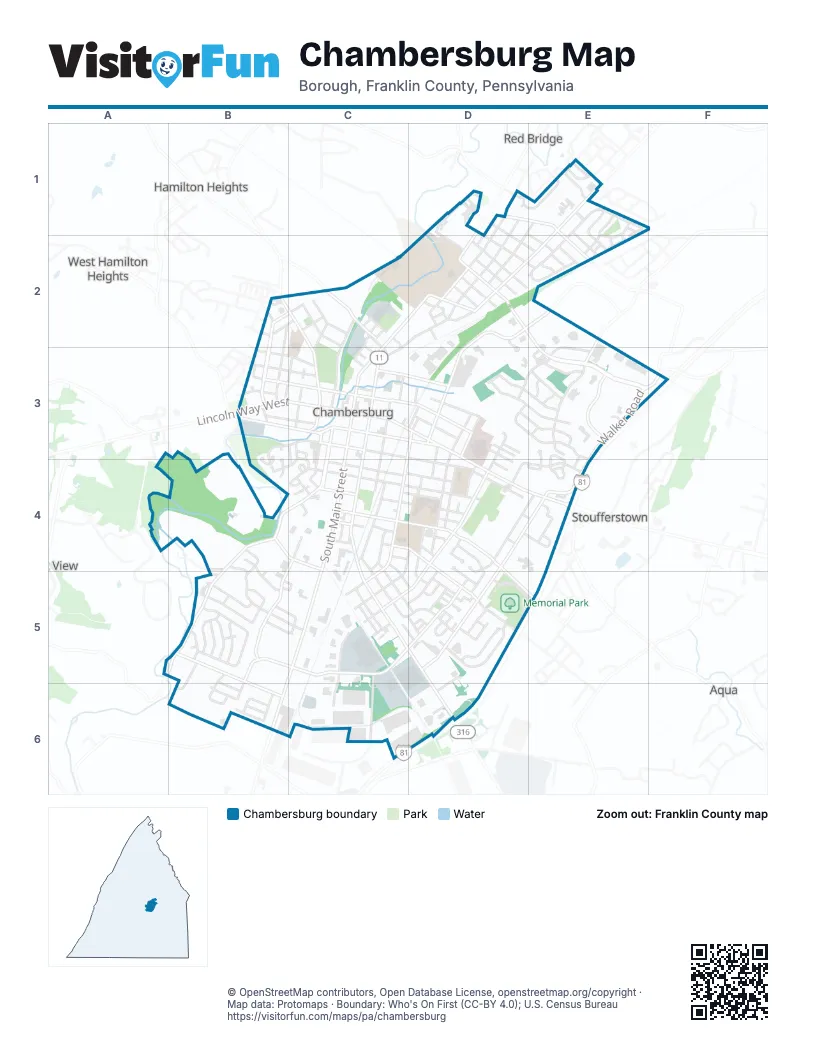
Street index of Chambersburg
Each street on the sheet and the grid squares it crosses.
- Norland AvenueD2, E2, E3
- South Main StreetC3, C4, C5, B6
- Lincoln Way EastC3, D3, D4, E4
- Wayne AvenueC4, C5, D5, D6
- Philadelphia AvenueC2, D2, C3
- South 2nd StreetC3, C4
- Lincoln Way WestB3, C3
- Edgar AvenueD1, D2
- West Loudon StreetB3, C3
- East Queen StreetC3, D3
- East Garfield StreetC4, D4
- West Queen StreetB3, C3
- North 2nd StreetC3
- College AvenueD2
- North Main StreetC3
- Molly Pitcher HighwayB6
- Lincoln WayC3
- Main StreetC3
- Walker RoadE3, F3, E4
- Orchard DriveD4, B5, C5, D5, B6
- Hollywell AvenueB4, C4, B5
- East McKinley StreetC4, D4, D5, E5
- Stouffer AvenueD4, E4, D5
- Scotland AvenueE1, D2, E2
- 5th AvenueD2, E2, D3
- South 4th StreetC3, D3, C4, C5
- South Coldbrook AvenueD4, C5, D5
- Stanley AvenueC4, D4, D5
- East King StreetC3, D3
- Progress RoadC4, B5
- East Washington StreetC3, D3, D4
- North Franklin StreetB2, C2, C3
- Parkwood DriveE3
- Mill RoadB5, B6
- Grandview AvenueB2, C2, B3
- West King StreetB3, C3
- West Washington StreetB3, C3, B4
- South Water StreetC3, C4
- West Commerce StreetC2, C3
- Gateway AvenueE3
- Grant StreetC3, D3
- Industrial DriveB4, C4
- Roland AvenueD1, E1
- Woodstock RoadE1, E2
- North 7th StreetD3
- North Parkwood DriveE3
- Scotland RoadE1, D2
- South Franklin StreetC3
- Boyer Mill RoadA5, B5
- Cedar StreetC3, C4
- West South StreetC4
- East South StreetC4
- East Catherine StreetC4, D4
- Cumberland AvenueC4, C5, D5
- Martina DriveB5
- Black AvenueC3, C4
- Wilson AvenueD1, D2
- Clinton AvenueE1, E2
- East Liberty StreetC4, D4
- Phoenix DriveD3, E3, E4
- South 6th StreetD3, D4
- Brandon DriveD5
- Eisenhower DriveB4, B5, C5
- Saint Paul DriveD3, E3
- Lanter LaneB5
- South Central AvenueC3, C4
- Hood StreetC2, C3
- Sunbrook DriveD3, E3
- North Penn Hall DriveD1
- Tolbert AvenueC4, D4
- 5th StreetC4, D4, C5
- Cleveland AvenueC4
- Matthew DriveD3, E3
- Brumbaugh AvenueD4, E4
- Broad StreetD2, C3
- West Catherine StreetC3, B4, C4
- Odds Even LaneC2, D2
- Alexander AvenueD1, E1, D2
- Glen StreetB2, B3
- Sheffler DriveC5, C6
- Nelson StreetD3, D4
- Memorial DriveD5, E5
- Access DriveE3, E4
- Ashley DriveE1, E2
- Greene Meadow LaneB5, C5
- South 3rd StreetC3, C4
- Ohio AvenueD2
- East Ludwig AvenueC3, D3
- Nitterhaus DriveC5, C6
- Hudson AvenueD2, E2
- Woodvale DriveD3, E3
- Blaze AvenueC2, D2
- Miller StreetB3, C3
- Prkg LotE2, D4, D5
- High StreetB3, C3
- Middle StreetD4, D5
- Wallace AvenueD4, C5, D5
- Leidig DriveD4, D5
- 7th StreetD4
- South Penn Hall DriveD1, D2
- Horst AvenueD1, D2, E2
- Beechwood LaneD1, E1
- Highland AvenueC4, C5, D5
- Limekiln DriveD4, E4
- Elm AvenueC4, D4
- Kelhigh DriveB6
- Edgelea DriveE2
- Duke AlleyC2, D2, C3
- Center StreetC2
- West Burkhart AvenueB3, C3
- Geyer DriveD5
- Lortz AvenueC4, D4
- Village ParkwayE1
- South Harrison AvenueC3, C4
- Pennsylvania AvenueD2
- Montgomery AvenueD3
- Columbia CourtD2
- Elder StreetC2
- Powell DriveE1, E2
- Cosell DriveB5
- Maryland AvenueC5
- Channing DriveB5
- Guilford AvenueC5
- Gall WayD2
- Martin AvenueB3, C3
- Ramsey AvenueD2
- Macintosh WayD5
- Garber StreetB3, C3
- North Coldbrook AvenueD3, D4
- Blanchard AvenueC4
- Roseanne DriveB5
- Washington StreetD4
- Sue Linn DriveB5
- North 4th StreetD3
- North 6th StreetD3
- Wilson College DriveD2
- Justine DriveE3
- Wolf AvenueC2, C3
- Heintzelman AvenueB2, C2
- Epic DriveE4
- Basset DriveE1, E2
- Ludwig AvenueD3, D4
- Plaster AvenueD4
- Wellslee DriveB5
- Benedict DriveB4, B5
- Westgate DriveD5
- Kenwood RoadD2
- Bracken DriveE1, E2
- Lincoln RoadB5, C5
- Riddle AlleyC2
- Stanley CourtC4, D4
- Cheree DriveB6
- Smith AvenueC3, C4
- Bishop AvenueB3
- Delaware CourtD2
- Belvidere CourtD2
- Stonegate Circle SouthE4
- Kraiss AvenueC4, C5, D5
- Rosewood CourtD4, D5
- South 8th StreetD4
- Park AvenueD2
- Parkside CourtD1
- East Point AvenueD3, D4
- Elrock DriveB5
- East Carolina CourtC5
- Carlton AvenueD1, E2
- Hamilton RoadB5, C5
- Rustic Hill DriveD5
- Sanibel LaneD5
- Rosemont CourtC2, C3
- Pleasant StreetC2, C3
- Sheller AvenueD5, D6
- Fairground AvenueC4
- Meriweather DriveB6
- Long LaneD5
- Floral AvenueC4, D4
- Windmill LaneE1
- Byers AvenueD5
- Weaver AvenueE2
- Stonegate Circle NorthE3, E4
- Southgate MallC3, C4
- Kennedy StreetC3
- South 5th StreetD4
- Coyote CourtD4
- Montgomery AlleyC3
- North 3rd StreetC3
- Cambridge CourtD1, D2
- Reservoir StreetC2
- Darwin CourtC2
- Calvert CourtD3
- Kyle AvenueC4
- South Federal StreetC3
- Nicholson BoulevardE1
- Kenebec DriveD4, E4
- Whitley DriveB5, B6
- Chambers Hill DriveD2, D3
- Pipeline AlleyC2, C3
- Burkhart AvenueC3
- West Vine StreetC2
- Rachel DriveB5, C5
- Cypress StreetD5
- Dakota CourtD2
- Buchannan StreetC4
- Derbyshire StreetC4
- South 7th StreetC5
- Bender farmE4
- Duncan AvenueD4
- Park View DriveB4, B5
- Spring StreetC3
- Dump RoadB4
- Meadowbrook LaneC5, D5
- Horizon WayE1
- Pine CourtC4
- Tobin DriveE3
- Highfield Lane NorthE3, E4
- Linden AvenueC3, C4
- Gilbert RoadC4
- Highfield Lane SouthE4
- Spring LaneD3
- Delano DriveB5, B6
- Mentzer AvenueE2
- Ruthraff AlleyC2, C3
- Tyler CourtC4
- Hamilton AvenueB2
- Paper Mill RoadB4
- Dewberry CourtD4
- Chambersburg High SchoolD4
- William Penn DriveD5
- Orchard CourtD4, D5
- Mount Moriah StreetC3, C4
- Bender AvenueD4
- West Liberty StreetC4
- Hemlock CircleC4
- North Harrison AvenueC3
- Central AvenueC3
- North Federal StreetC3
- East Gilbert AvenueC4
- Laurel AvenueE2
- Rhodes DriveC3
- Harrison AvenueC3
- Monticello CourtB3
- Paul AvenueC4
- Andrew CourtD4
- Oak StreetC4
- Tucker DriveE3
- Birch StreetC3, C4
- Larch AvenueC3
- Acces DriveD2
- West Irva DriveB3, B4
- Light CourtC3
- Wright AvenueC3, D3
- Rife StreetC2
- Hazel StreetC2, C3
- Cree DriveD6
- Redwood StreetC4
- Riddle RoadD2
- East Vine StreetC2, C3
- Penn Wood CourtD1
- Poplar AvenueC2
- Benedict AvenueB4
- Independence CourtC3
- Harrison DriveB2
- Houser AlleyC4
- Wilson College LaneD2
- Chambers StreetC3
- Chancellor DriveD1
- Debrina CourtB5
- Candlestick CourtC4
- Washington Street ExtensionD4
- Champions DriveD2
- North Hackberry DriveB4
- Bedington BoulevardE3
- Wet South StreetC4
- North StreetD2
- East Irva DriveB3, B4
- Franklin Square DriveE1
- Woodlawn DriveD5
- Suburban DriveB2
- Manila CourtB3
- Stonegate CourtE4
- Race StreetC2
- Brookview AvenueB3
- Lakewood CourtD1
- Menno Haven DriveE1
- Seaton CourtC2
- Meadow DriveD5
- Federal StreetC3
- Rudy DriveB5
- Rutherford CourtD4
- Short DriveE3
- Brookwood DriveD5
- Locust StreetD4
- South Hackberry DriveB4
- Summer StreetD4, E4
- 8th StreetD4
- Apple Blossom WayD5
- Woodlawn CircleC5, D5
- East Commerce StreetC3
- Morrow PlaceD2
- Cambridge LaneD5
Places on the map
- ACNB Bank
- Advance Auto Parts
- Advanced Graphix
- Aldi
- Amselys'
- AMVETS Post 224
- Andrew Buchanan Elementary School
- Applebee's
- Arby's
- Ashley HomeStore
- AutoZone
- Benjamin Chambers Elementary School
- Berg Brewing Company
- Best Western Chambersburg
- BJ's Gas
- BJ's Wholesale Club
- Borough of Chambersburg Municipal Building
- Buffalo Wild Wings
- Burger King
- Candlewood Suites
- Capital Restaurant
- Carson's Motel
- Central Presbyterian Church
- Chambers' Apothecary
- Chambersburg Aquatic Center
- Chambersburg Area Senior High School
- Chambersburg Crossing
- Chambersburg Dental Associates
- Chambersburg Post Office
- City Center
- East Catherine Street
- Faust Soccer Grounds
- Henninger Field
- Lincoln Cemetery
- Memorial Park
- Norland
- Target
- Wayne Plaza
- Weis Plaza
- WellSpan Chambersburg Hospital
Next to Chambersburg
- Aqua
- Hamilton Heights
- Red Bridge
- Stoufferstown
- West Hamilton Heights
© OpenStreetMap contributors, Open Database License, openstreetmap.org/copyright · Map data: Protomaps · Boundary: Who's On First (CC-BY 4.0); U.S. Census Bureau















