

Pennsylvania map
Ephrata map
About 13,719 people live here (Census Bureau, 2024 estimate). The sheet's index lists 240 streets; West Main Street, Dawn Avenue and South Reading Road cross the most grid squares. Things to do inside the boundary: Ephrata Cloister, Fox Meadows Creamery and Country Market and Re-Uzit Shop of Ephrata.
Open the map (PDF, US Letter)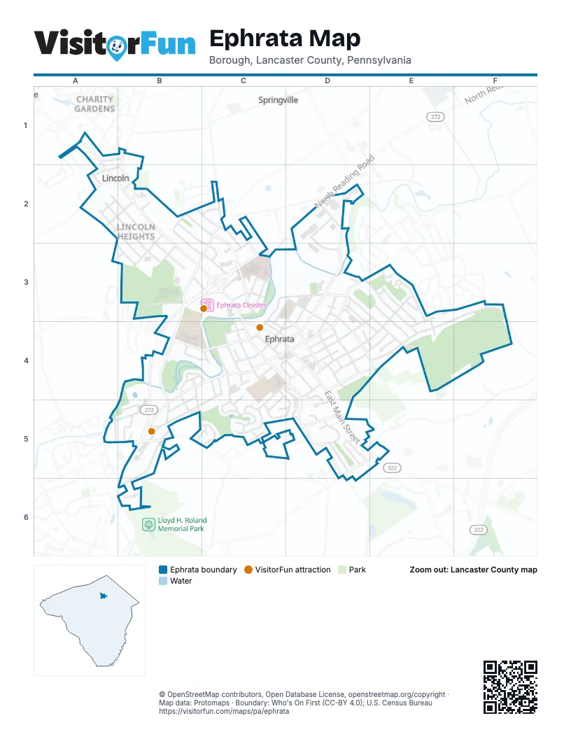
Street index of Ephrata
Each street on the sheet and the grid squares it crosses.
- Lincoln AlleyA1, A2, B2
- Reagan DriveA1
- Robert RoadA1, B1
- West Main StreetA1, A2, B2, B3, C3, C4, D4
- Apple StreetB1, B2
- Lincoln Gardens RoadB1
- Galen AlleyA2
- Hummer RoadA2, B2
- Julia RoadA2
- Lincoln Heights AvenueA2, B2, B3
- Marie AvenueA2, B2, B3
- Marilyn AvenueA2, B2, B3
- North Charles StreetA2, B2
- North Market StreetA2, B2
- South Charles StreetA2
- South Market StreetA2
- Thomas RoadA2
- Trailer Court DriveA2
- Cindia LaneB2
- Clearview AvenueB2, C2, C3
- Crescent AvenueB2, B3
- Dawn AvenueB2, C2, B3, C3
- Fairview AvenueB2, C2, C3
- Martin AvenueB2, C2, C3
- Miller AlleyB2
- Union StreetB2
- Holly DriveC2, C3
- Manor StreetC2
- North Academy DriveC2, B3, C3
- Pleasant View RoadC2
- Stevens RoadC2
- Valerie AvenueC2
- Church AvenueD2, D3, D4
- Cloverbrook DriveD2
- East Trout Run RoadD2
- Industrial DriveD2
- North Reading RoadD2, B3, C3
- Trout Run RoadD2
- Wenger DriveD2, D3
- Joann AvenueA3, B3
- Academy Heights AvenueB3, C3
- Blossom AvenueB3
- Buch AlleyB3
- Hammon AvenueB3
- Old Mill RoadB3, B4, B5
- South Academy DriveB3
- South Reading RoadB3, C3, B4, B5
- Susan CircleB3
- 1st StreetC3
- 2nd StreetC3
- 3rd StreetC3
- Andrew AvenueC3
- Broad StreetC3, C4
- Cloister AlleyC3
- Cloister AvenueC3
- Cocalico StreetC3, C4
- Ephrata AvenueC3
- Grandview DriveC3
- Highland AvenueC3, D3, C4
- Lancaster AvenueC3
- Moyer AlleyC3
- Museum AlleyC3, C4
- North Oak StreetC3, C4
- Penn AvenueC3
- Rupp AlleyC3, C4
- West Fulton StreetC3, C4
- West Pine StreetC3, D3
- West Sunset AvenueC3, C4
- Acorn AlleyD3, D4
- Bridge AlleyD3, D4
- Carpenter AlleyD3
- Duke StreetD3, D4
- East Pine StreetD3, E3, E4
- East Walnut StreetD3, D4, E4
- Eshelman AlleyD3, E3
- Farm LaneD3
- Groff AlleyD3, D4
- Lee AlleyD3, D4
- New StreetD3, D4
- North State StreetD3, D4
- Park AvenueD3, C4, D4
- Peach AlleyD3
- Pine AlleyD3
- Ream AlleyD3, D4
- Sheaffer AlleyD3, D4
- Showers AlleyD3
- Spruce AlleyD3, C4, D4
- Spruce StreetD3, D4, E4
- State AlleyD3, D4
- Terrace AvenueD3, C4
- West Chestnut StreetD3, D4
- West Locust StreetD3, D4
- West Walnut StreetD3
- White Pine AlleyD3, E3
- Clover CourtE3
- Heather LaneE3
- Hemlock RoadE3, E4
- Irene AvenueE3, E4
- Kathi AvenueE3
- Lincoln AvenueE3, D4, E4
- Linda TerraceE3
- Marion TerraceE3, E4
- North Maple StreetE3, F3, D4, E4
- Stoneridge CircleE3
- Timothy LaneE3, E4
- Tuckson AvenueE3, E4
- Washington AvenueE3, D4
- East Mohler Church RoadF3
- Mohler S Church RoadF3
- Ba-Ru-Be AlleyB4, B5
- Burkey LaneB4
- Center AvenueB4, B5
- Circle DriveB4, C4
- Emerald StreetB4
- Gerhart AvenueB4, B5
- Legion AvenueB4
- Lemon StreetB4, B5
- Meadow Valley RoadB4
- Oak BoulevardB4, C4
- Oaklawn BoulevardB4
- Opal StreetB4
- Pershing AvenueB4, C4
- South State StreetB4, C4, D4, B5
- Woodlawn AvenueB4
- Adams AlleyC4, D4
- Arch AlleyC4
- Arch StreetC4
- Boomerang DriveC4, C5, D5
- Church AlleyC4
- East Fulton StreetC4, D4, D5, D6
- East King StreetC4
- East Orange StreetC4
- East Queen StreetC4, C5
- East Sunset AvenueC4
- Gross AlleyC4
- Gross StreetC4, D4
- Hess AlleyC4
- Hess CircleC4
- Hunter AlleyC4
- Lake StreetC4, D4, C5
- Legion AlleyC4
- Lime StreetC4
- Mortar LaneC4, C5
- Nissley AlleyC4
- North Church StreetC4, D4
- Park WayC4
- Pointview AvenueC4, B5
- Poplar StreetC4, D4
- Railroad AvenueC4
- Richin AlleyC4
- Ridgeway AvenueC4
- Russel AlleyC4
- Russell AlleyC4
- Short AlleyC4
- South Church AvenueC4
- South Oak StreetC4
- Sugar AlleyC4, D4, D5
- Vine StreetC4
- Vista DriveC4, C5
- Warwick to Ephrata Rail TrailC4, D4
- West Franklin StreetC4
- West King StreetC4
- West Pointe LaneC4, D4
- West Queen StreetC4
- Westpointe DriveC4, D4, D5
- Butternut StreetD4
- Cedar StreetD4, E4
- Cherry StreetD4
- Conestoga AlleyD4
- Diller AlleyD4
- East Chestnut StreetD4
- East Franklin StreetD4
- East Hill StreetD4
- East Locust StreetD4
- East Main StreetD4, D5, E5
- Grant StreetD4
- Grape AlleyD4
- Hazel AlleyD4
- Howard AvenueD4, E4
- Huber AlleyD4
- Johnson AlleyD4
- Lauren LaneD4, D5
- Marshall AlleyD4
- Marshall StreetD4
- Mentzer AlleyD4
- Messner AlleyD4
- Mountain StreetD4, D5
- New AlleyD4
- Plum AlleyD4
- Poplar AlleyD4
- Rose AlleyD4
- South Maple StreetD4
- Spring Garden StreetD4, E4
- Walnut AlleyD4
- Warwick-Ephrata Rails to TrailsD4
- Weinhold AlleyD4
- Spring Garden AlleyE4
- Stephen CircleE4
- Tower RoadE4
- James AvenueA5
- Niss AvenueA5, B5
- Rettew Mill RoadA5
- Ashley DriveB5, C5
- Bellevue AvenueB5
- Community LaneB5
- Henn AvenueB5
- Hurst DriveB5
- Kachel AlleyB5
- Linden RoadB5
- Martzall's CourtB5
- Parkview Heights RoadB5, C5
- Pyle Mobile Home ParkB5
- Rothsville RoadB5
- Steinmetz RoadB5, B6
- Sycamore RoadB5
- Akron RoadC5, D5
- Brickyard CircleC5
- Garrett CircleC5
- Gery CourtC5
- Glen CourtC5
- Heatherwood DriveC5
- Kings CourtC5
- Mason DriveC5
- Pavers LaneC5
- Sand CourtC5
- Vista CircleC5, D5
- Windsor CourtC5
- Windsor DriveC5
- Bethany RoadD5, E5
- Gregg CircleD5
- Jeff AvenueD5
- Julie Ann CourtD5
- Landis LaneD5
- Landis RoadD5
- Michael CourtD5
- Sherry CourtD5
- Tom AvenueD5
- Tricia LaneD5
- Wyneberry DriveD5
- North 11th StreetB6
Things to do on the Ephrata map
Places on the map
- American Legion Cloister Post 429
- AMVETS Post 136
- APlus
- Applebee's
- AutoZone
- Bethany Playground
- Bethany United Church of Christ
- Bowmans Cemetery
- Brickyard Park
- Casa Huerita
- Cedar Hill Cemetery
- Cocalico Valley VFW Post 3376
- Cornerstone Mennonite Church
- Dairy Queen
- Dutchland Diner
- Ebenezer Groceries
- Edgewater Meadow Park
- Eicher Arts Center
- Ephrata Area Recreation Center
- Ephrata Beverage Mart
- Ephrata Bike Park at Heatherwood
- Ephrata Church of the Brethren
- Ephrata Cloister
- Ephrata Commercial Historic District
- Ephrata High School
- Ephrata Mountain
- Ephrata Mountain Conservation Area
- Ephrata Nature Reserve
- Fulton Elementary School
- Haller Homestead
- Highland Elementary School
- Liberty Baptist Church
- Moyer's Meadow Park
- Nissley Park
- Saint Clement’s Mission
- The Terraces Park
- The UPS Store
- Thomas P. Grater Memorial Park
- WellSpan Ephrata Community Hospital
Next to Ephrata
- Charity Gardens
- Springville
© OpenStreetMap contributors, Open Database License, openstreetmap.org/copyright · Map data: Protomaps · Boundary: Who's On First (CC-BY 4.0); U.S. Census Bureau















