

Pennsylvania map
Harrisburg map
About 50,649 people live here (Census Bureau, 2024 estimate). The sheet's index lists 300 streets; North Front Street, North 2nd Street and North 4th Street cross the most grid squares. Things to do inside the boundary: City Island, Pennsylvania Tourism Office and State Museum of Pennsylvania.
Open the map (PDF, US Letter)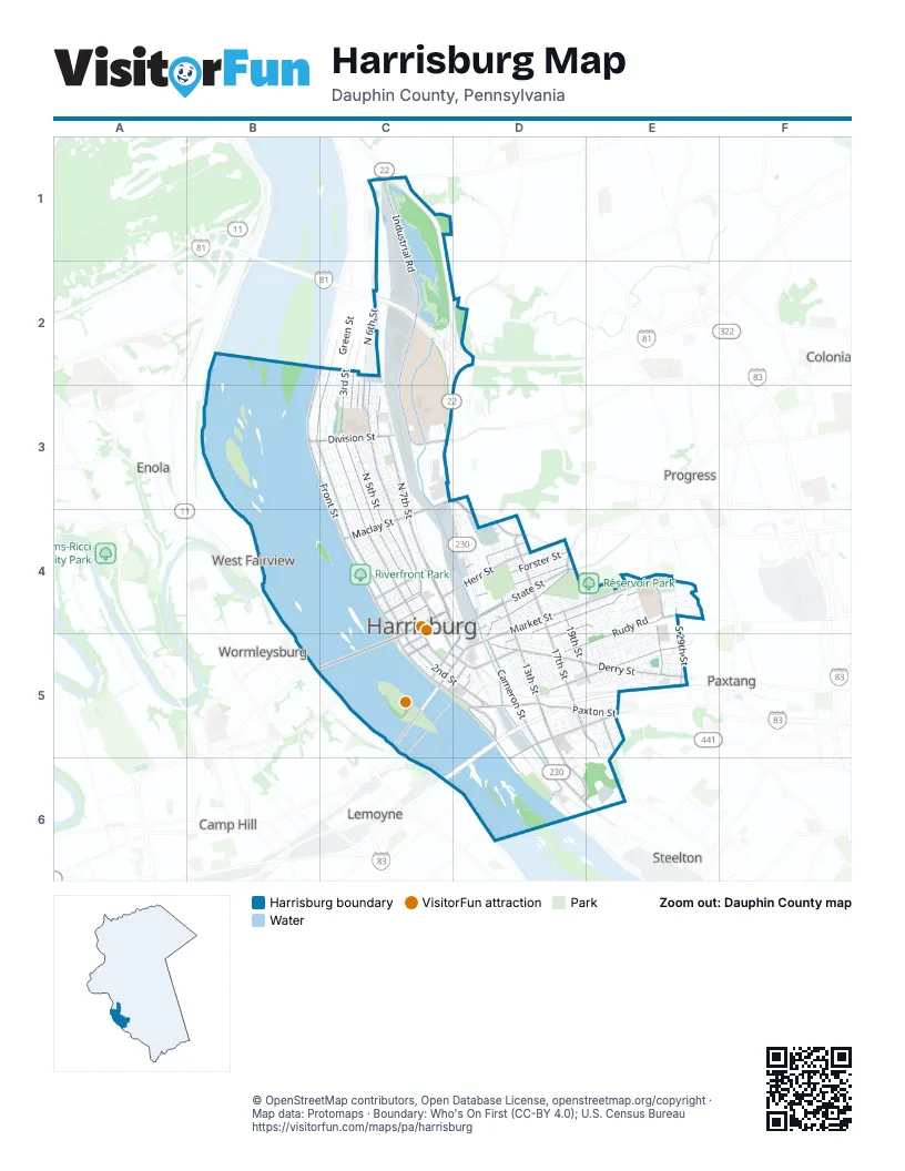
Street index of Harrisburg
Each street on the sheet and the grid squares it crosses.
- North Cameron StreetC3, D3, D4, D5
- American Legion Memorial HighwayC2, D2
- North 2nd StreetC2, B3, C3, C4, C5
- North Front StreetB2, C2, B3, C3, C4, C5
- North 7th StreetC3, C4
- Market StreetD4, E4, C5, D5
- Industrial RoadC1, C2, C3
- State StreetD4, C5
- South Cameron StreetD5, D6, E6
- South 13th StreetD4, D5, D6, E6
- Walnut StreetD4, C5, D5
- North 5th StreetC2, C3, C4, D5
- Forster StreetC4, D4, C5
- Herr StreetC4, D4
- M. Harvey Taylor BridgeB5, C5
- Paxton StreetD5, E5
- South Front StreetC5, D5, D6
- Maclay StreetC3, C4
- Arsenal BoulevardC3, D3, D4
- Division StreetB3, C3
- South 2nd StreetC5, D5
- North 13th StreetD4
- Randall Shugart StreetD5
- Fisher PlazaC4, D4
- Linglestown RoadC1
- South 28th StreetE4, E5
- Jonestown RoadD4, D5
- Market Street BridgeC5
- Mountainview RoadC1
- North 3rd StreetC2, C3, C4, C5
- North 6th StreetC2, C3, C4
- North 4th StreetC2, C3, C4, C5, D5
- Derry StreetD5, E5
- Chestnut StreetD4, E4, C5, D5
- South 17th StreetD4, D5, E5
- South 19th StreetD4, D5, E5
- Sycamore StreetD5, E5, D6
- North 17th StreetD4
- Mulberry StreetD4, E4, D5
- Reily StreetC4, D4
- Commonwealth AvenueC4, C5
- Mulberry Street BridgeD5
- South 4th StreetD5
- Elmerton AvenueC3
- Brookwood StreetD5, E5
- Verbeke StreetC4, D4
- Rudy RoadE4, D5, E5
- North StreetC4, D4, C5
- South 25th StreetE4, E5
- South 29th StreetE4, E5
- Hoffman StreetC2, C3
- Wildwood Park DriveC3
- Parkway DriveD4
- Crooked Hill RoadD2
- Green StreetC2, C3, C4, C5
- Penn StreetC2, C3, C4, C5
- Susquehanna StreetC3, C4, C5
- Logan StreetC2, C3, C4
- Berryhill StreetD5, E5
- Swatara StreetE4, D5, E5
- South 18th StreetD4, D5, E5, E6
- Boas StreetC4, D4
- Jefferson StreetC3, C4
- North 15th StreetD4
- South 20th StreetD4, E5
- South 15th StreetD4, D5, D6, E6
- Cumberland StreetC4, D4
- Bellevue RoadD4, E4
- Atlas StreetC3, C4
- North 16th StreetD4
- Briggs StreetC4, D4, C5
- North 18th StreetD4
- Alumni DriveC2, C3
- South 14th StreetD4, D5, D6
- Thompson StreetD5, E5
- Calder StreetC4, D4
- South 16th StreetD4, D5
- Greenwood StreetE5
- Kelker StreetC4, D4
- Fulton StreetC4
- South 21st StreetE4, E5
- Kensington StreetE4, D5, E5
- Schuylkill StreetC3
- Muench StreetC4, D4
- Seneca StreetC3
- Zarker StreetD4, E4
- North 14th StreetD4
- Emerald StreetC3, C4
- Woodbine StreetC3, C4
- Peffer StreetC4
- Ethel StreetD4
- South 22nd StreetE4, E5
- Radnor StreetC3
- Harris StreetC4, D4
- Hamilton StreetC4
- Riverside DriveC5
- Wiconisco StreetC3
- HACC DriveC3
- Central StreetE5
- Rumson DriveE4
- May StreetD4
- Parkhill LaneD4, E4
- Liberty StreetD4, C5
- Clinton StreetC4
- Edward StreetB3, C3
- Hale AvenueE4, E5
- Regina StreetD4
- Dauphin StreetC4, D4
- Granite StreetC4
- Rolleston StreetE5
- Graham StreetB3, C3
- Dean StreetE5
- Evergreen StreetD4, D5
- Primrose StreetD4
- Hunter StreetD5
- Woodlawn StreetE5
- Miller StreetD4
- Turner StreetC3, C4
- Orange StreetC3, C4
- Sullivan AlleyD5, E5
- Delaware StreetC4, D4
- North 19th StreetD4
- York StreetD4
- Reservoir DriveD4
- Whitehall StreetD4, E4
- South 23rd StreetE4, E5
- Lewis StreetB3, C3
- Sassafras StreetC4, D4
- Kunkel StreetD4
- Arch WayE4
- Geiger StreetC4
- South 24th StreetE4, E5
- Vaughn StreetC2
- Park StreetD4
- Taylor BoulevardD4, E4
- Dr. Claude E. Nichols StreetD4
- Reel StreetC3
- Brensinger AlleyC3, C4
- Holly StreetE4, D5
- North 20th StreetD4
- Hanover StreetE5, D6
- James StreetC3, C4
- Wildwood WayC2
- Cona StreetE5
- Sayford StreetC4
- Wayne StreetD5, E5
- Magnolia DriveE4
- River AlleyB3, C3, D5
- Valley RoadE4
- Revere StreetD5, E5
- Crescent StreetD5
- Rhoads AlleyC4
- McCleaster StreetD5, E5
- Linden StreetD4, D5
- Lexington StreetC3
- Hillside RoadE4, E5
- Brown StreetD4
- South 10th StreetD5
- Wallace StreetC4
- Vernon StreetD5
- Helen StreetD4
- Hummel StreetD5
- Kittatinny StreetD5
- South 26th StreetE5
- South 12th StreetD6, E6
- Hanover RoadD5, E5, D6, E6
- North 10th StreetD4, D5
- Brady StreetD4
- North River StreetC5
- Championship WayC5
- South StreetC5, D5
- Finn AlleyC3
- Briar Cliff RoadE4
- Mc Cleaster StreetE4, E5
- Nectarine StreetD5
- Pigeon StreetD6
- Hudson StreetE5
- Mayflower StreetD5
- Raleigh StreetE5
- River StreetC2, B3, C3
- Syndicate StreetE5
- Bartine StreetC4, C5
- Pentwater RoadE4
- Cascade AlleyD5, E5
- Linn StreetD4
- Melrose StreetE5
- Salmon StreetD5
- South River StreetC5, D5
- Darlington AlleyD5, E5
- Blackberry StreetC5, D5
- North 12th StreetD4
- Ellsworth AlleyE4, D5
- Farm Show DriveC3
- Flinton StreetE5
- Shellis StreetD5, E5
- Concert DriveD4
- Girard StreetE5
- Basin StreetC4
- Benton StreetE5
- Reese StreetD5
- Wilson ParkwayE4
- North Court StreetC5
- Norwood StreetD4, E4, E5
- Curtin StreetC3
- Karper StreetE5
- South 3rd StreetC5, D5
- Duke StreetE5
- Albert StreetD5
- Kline PlazaE4
- Eugene AlleyD4, E4, D5
- Naudain StreetD5, E5
- Camp StreetC3
- Agate StreetC3
- Forest StreetC4, D5
- Joseph AlleyC2, C3
- Kemp AlleyC2, C3
- Marie AlleyC2, C3
- Pennwood RoadC2, C3
- Midland RoadE4
- Ella AlleyD5
- Dunkle StreetD5, E5
- Boyd StreetC4
- South 27th StreetE5
- Buckthorn StreetD5
- Aberdeen StreetC5, D5
- Capitol StreetC4
- Manada StreetD5, E5
- Fair StreetE5
- Julia StreetC3, C4, D4
- Strawberry StreetC5, D5
- Austin StreetD4, E4
- Angenese StreetC3
- Knox StreetE5
- Spencer StreetD5, E5
- Chamberlain DriveE4
- Pemberton StreetE5
- Bailey StreetD4
- Shamokin StreetB3, C3
- Randolph StreetD5
- Antoine StreetC3
- Poplar StreetD4
- Union StreetC4, C5
- Mercer StreetE5
- Elizabeth StreetC3, C4
- Haehnlen StreetD5
- Glen StreetE5
- Clark StreetC3
- Showers StreetD5
- Apricot StreetD4
- Avon AlleyC3
- Parkside LaneC3
- Mary StreetD5
- Croyden RoadE4
- Compass AlleyD5
- Innovation WayC3
- Martina StreetC3
- Hetrick StreetE5
- Walnut Street UnderpassC4, D4, D5
- Ivey LaneE6
- Cathedral StreetD4, E4
- Ione StreetD5
- Wharton AlleyC3, C4
- Alricks StreetC2
- Platt StreetE5
- Waldo StreetC3
- Orleans StreetC2, C3
- Daisy StreetD5
- Long StreetD4
- Marie StreetC2, C3
- Oakwood RoadE4
- Charles StreetC4, D4
- Shrub StreetD4
- Pine StreetC5
- Locust StreetC5
- Reels LaneC3
- Balm StreetD4
- Meyers AlleyC4
- Magnolia StreetD6
- Race StreetD5
- Fox Ridge CourtC4
- Reily RoadD4
- Vine StreetD5
- Hatton StreetE5
- Bombaugh StreetD4
- Lennox StreetE5
- Myers AlleyC4
- Wood StreetC4
- Burma StreetE5
- Adrian StreetE5
- Herman AlleyC4
- Oxford StreetC3
- South Dewberry StreetD5
- Klemm StreetC2
- Manor StreetB3, C3
- Scott StreetD6
- Putnam StreetD5, E5
- Crooked StreetD4, D5
- Ross StreetC3
- Ice StreetE5
- Howard StreetD5
Things to do on the Harrisburg map
Places on the map
- 3rd Street Used Furniture Store
- 4th & Emerald Playground
- 5th St. Garage
- 7-Eleven
- 7th & Radnor Sports Park
- 7th Street Garage
- Allison Hook & Ladder Company No 2
- Alva Hotel and Restaurant
- Asia Mall
- Asia PA Market
- Athletic Fields
- Atlas Street Community Garden
- AutoZone
- Benjamin Franklin Elementary School
- Broad Street Market
- Calvary Cemetery
- City Island
- City Island Southern Marina
- Federal Square Post Office
- Foose Elementary School
- Harrisburg Cemetery
- Harrisburg Transportation Center
- Harrisburg University of Science and Technology
- Headquarters 28th Infantry Division
- Italian Lake
- Italian Lake Park
- Kline Plaza
- Pennsylvania Canal
- Pennsylvania State Capitol
- Phoenix Park
- Prospect Hill Cemetery
- Riverfront Park
- Sheets Island
- Sheets Island Archipelago Natural Area
- Strawberry Square
- UPMC Harrisburg
- UPMC Polyclinic Medical Building
- Wildwood Lake
- Wildwood Park
Next to Harrisburg
- Camp Hill
- Colonial Park
- Enola
- Lemoyne
- Paxtang
- Progress
- Steelton
- West Fairview
- Wormleysburg
© OpenStreetMap contributors, Open Database License, openstreetmap.org/copyright · Map data: Protomaps · Boundary: Who's On First (CC-BY 4.0); U.S. Census Bureau















