

Pennsylvania road map
I-476 in Pennsylvania map
I-476 is about 125 miles in Pennsylvania. It has 29 exits, from Exit 1 at mile 0 to Exit 131, Clarks Summit at mile 124. It meets 35 highways, among them I-76, I-78 and I-80.
Open the map (PDF, US Letter)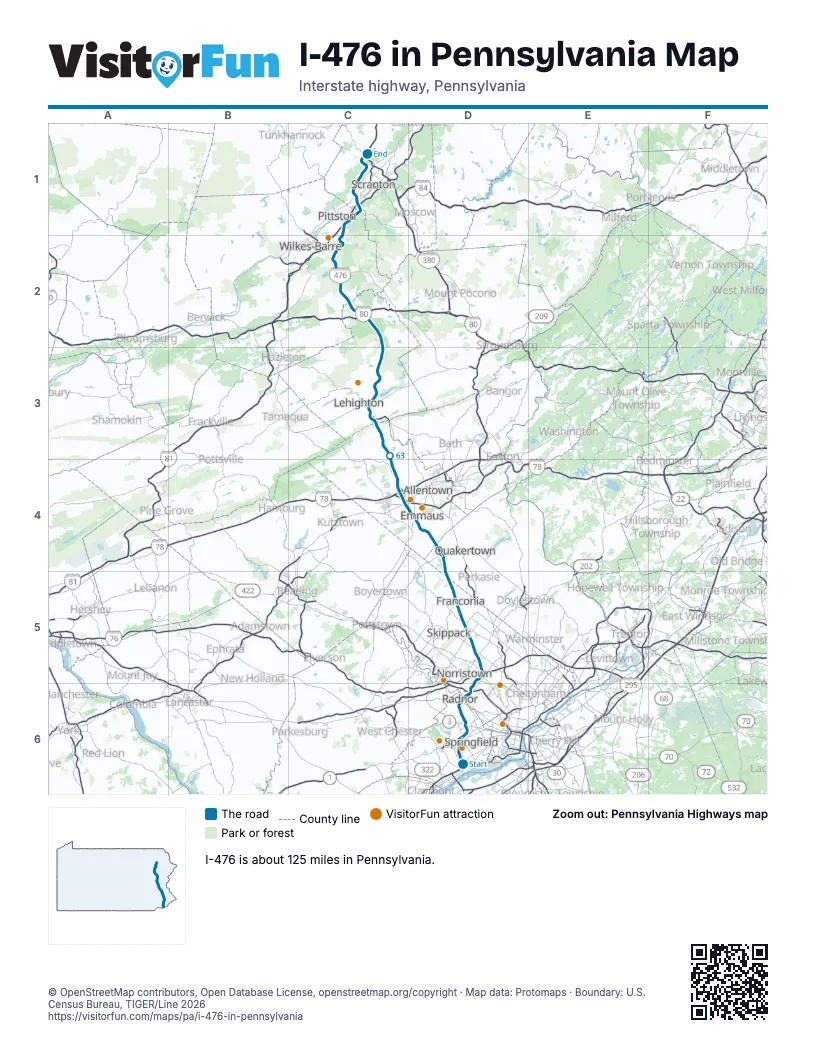
Exits on I-476 in Pennsylvania
Each exit in mile order, with its grid square.
- Exit 1mile 0, D6
- Exit 3mile 3, D6
- Exit 9mile 8, D6
- Exit 13mile 12, D6
- Exit 331Amile 14, D6
- Exit 331Bmile 15, D6
- Exit 16Bmile 15, D6
- Exit 16mile 15, D6
- Exit 18Amile 17, D5
- Exit 18Bmile 17, D5
- Exit 18mile 17, D5
- Exit 19mile 18, D5
- Exit 20mile 18, D5
- Exit 333, Norristownmile 18, D5
- Exit 31A, Lansdalemile 28, D5
- Exit 31B, Lansdalemile 29, D5
- Exit 31, Lansdalemile 29, D5
- Exit 44, Quakertownmile 43, D4
- Exit 56, Lehigh Valleymile 56, C4
- Exit 74, Mahoning Valleymile 73, C3
- Exit 87, SR 903mile 85, C2
- Exit 277mile 91, C2
- Exit 95, Poconomile 92, C2
- Exit 105, Wilkes-Barremile 103, C2
- Exit 175Bmile 111, C1
- Exit 115, Wyoming Valleymile 111, C1
- Exit 180mile 115, C1
- Exit 122, Keyser Avenuemile 117, C1
- Exit 131, Clarks Summitmile 124, C1
Highways I-476 meets
Each highway it meets and the grid squares where they meet.
- PA 320D6
- US 1D6
- PA 3D6
- US 30D6
- I-76D6
- PA 23D6
- I-276D5
- US 202D5
- PA 73D5
- PA 363D5
- PA 63D5
- PA 113D5
- PA 563D5
- PA 663D4
- PA 29D4
- I-78C4
- US 222C4
- US 22C4
- PA 309C4
- PA 329C4
- PA 873C3
- PA 895C3
- PA 248C3
- US 209C3
- PA 903C3
- PA 534C2
- I-80C2
- PA 940C2
- PA 115C2
- PA 502C1
- I-81C1
- US 11C1
- PA 307C1
- US 6C1
- PA 407C1
Towns along I-476 in Pennsylvania
In mile order, with the grid square of each.
- Woodlynmile 0, D6
- Chestermile 0, D6
- Ridley Parkmile 0, D6
- Folsommile 1, D6
- Swarthmoremile 2, D6
- Rose Valleymile 2, D6
- Mediamile 3, D6
- Broomallmile 5, D6
- Drexel Hillmile 6, D6
- St. Davidsmile 11, D6
- Villanovamile 11, D6
- Rosemontmile 12, D6
- West Conshohockenmile 15, D6
- Swedelandmile 15, D6
- Conshohockenmile 16, D6
- Plymouth Meetingmile 18, D5
- Blue Bellmile 19, D5
- Kulpsvillemile 27, D5
- Harleysvillemile 30, D5
- Milford Squaremile 41, D4
- Spinnerstownmile 42, D4
- Emmausmile 49, D4
- Wescosvillemile 53, C4
- Dorneyvillemile 53, C4
- Cetroniamile 54, C4
- Allentownmile 55, C4
- Schnecksvillemile 60, C4
- Slatingtonmile 66, C3
- Slatedalemile 67, C3
- Palmertonmile 70, C3
- Bowmanstownmile 71, C3
- Parryvillemile 72, C3
- Weissport Eastmile 73, C3
- Albrightsvillemile 86, C2
- Penn Lake Parkmile 96, C2
- Bear Creek Villagemile 102, C2
- Laurel Runmile 104, C2
- Laflinmile 108, C2
- Yatesvillemile 109, C1
- Dupontmile 111, C1
- Avocamile 112, C1
- Duryeamile 113, C1
- Moosicmile 113, C1
- Old Forgemile 115, C1
- Taylormile 116, C1
- Scrantonmile 116, C1
- Chinchillamile 123, C1
- Clarks Summitmile 123, C1
- Clarks Greenmile 124, C1
Things to do on the I-476 in Pennsylvania map
© OpenStreetMap contributors, Open Database License, openstreetmap.org/copyright · Map data: Protomaps · Boundary: U.S. Census Bureau, TIGER/Line 2026