

Pennsylvania map
Lancaster map
About 58,441 people live here (Census Bureau, 2024 estimate). The sheet's index lists 300 streets; East Walnut Street, North Plum Street and South Duke Street cross the most grid squares. Things to do inside the boundary: Fulton Theatre, Historic Rock Ford and Lancaster City Welcome Center.
Open the map (PDF, US Letter)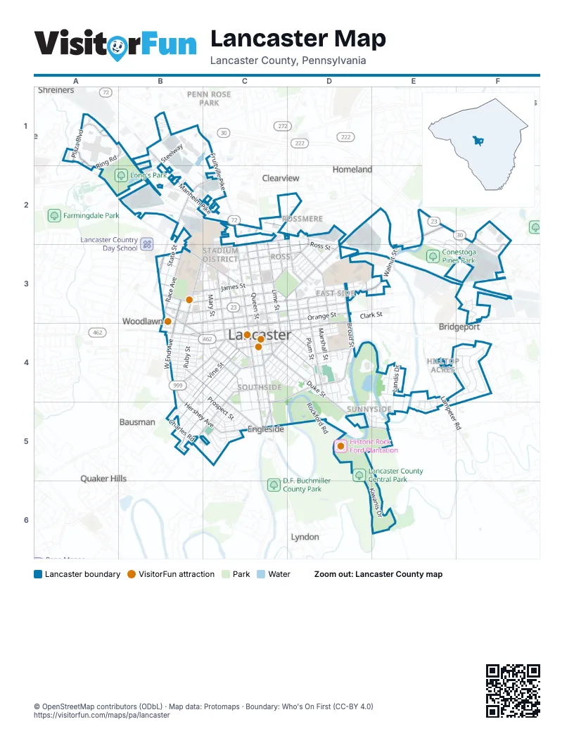
Street index of Lancaster
Each street on the sheet and the grid squares it crosses.
- East Walnut StreetE2, C3, D3, E3
- New Holland AvenueD2, C3, D3
- East Orange StreetC3, D3, C4
- North Plum StreetC2, D2, D3, D4
- North Prince StreetC2, C3, C4
- North Lime StreetC2, C3, C4
- North Queen StreetC3, C4
- South Queen StreetC4, C5
- East King StreetD3, C4, D4
- South Prince StreetC4, C5
- East Chestnut StreetC3, D3
- North Duke StreetC2, C3, C4
- West Walnut StreetB3, C3
- North President AvenueB3
- Manheim PikeB1, B2, C2
- Harrisburg AvenueB3, C3
- Dillerville RoadB2, C2
- College AvenueB3, B4
- West James StreetB3, C3
- West Chestnut StreetB3, C3, B4
- Manor StreetB4, C4
- West King StreetB4, C4
- West Orange StreetB4, C4
- South Lime StreetC4, D4
- Marietta AvenueB3, B4, C4
- Harrisburg PikeA1, A2, B2
- East Liberty StreetC2, D2, C3
- Fruitville PikeC1, C2
- Church StreetC4, D4
- North Broad StreetD3
- Columbia AvenueB4
- McGovern AvenueC2
- Highland AvenueC5
- Old Philadelphia PikeF4
- Lititz PikeC2
- Lincoln Highway EastF4
- Willow Street PikeC5
- South Duke StreetC4, D4, D5, E5
- Hershey AvenueB4, B5, C5
- Fairview AvenueB4, C4, C5
- Race AvenueB3
- Pitney RoadF2, E3, F3
- North Charlotte StreetC2, C3, C4
- North Franklin StreetD3, D4
- West Liberty StreetB3, C3
- Chesapeake StreetC4, D4, C5
- South Broad StreetD3, D4
- East Clay StreetC3, D3
- Hempstead RoadF2, F3
- South West End AvenueB4
- West Clay StreetB3, C3
- Greenfield RoadF2, F3
- South Shippen StreetD4
- East James StreetC3
- Lampeter RoadE4, E5
- Millport RoadE5
- Ring RoadA1, B1, A2
- Union StreetC4, B5
- Saint Joseph StreetB4, C4, B5
- Plaza BoulevardA1
- West Vine StreetB4, C4
- East Ross StreetD2, C3, D3
- Wabank RoadC4, B5, C5
- North West End AvenueB3, B4
- South Ann StreetD4
- North Shippen StreetC2, C3, D3, D4
- West Lemon StreetB3, C3
- North Mulberry StreetC3, C4
- New Dorwart StreetC4
- Park AvenueD2, C3, D3
- North Ann StreetD2, D3, D4
- New Dauphin StreetD4
- East Lemon StreetC3
- Hazel StreetC4
- Buchanan AvenueB3
- Pleasure RoadE2, E3
- West Strawberry StreetC4
- Conestoga StreetC4
- East Filbert StreetC4
- Marshall AvenueC2, D2
- East Vine StreetC4
- Ranck Mill RoadE3
- West Filbert StreetC4
- Ranck AvenueD3
- Martha AvenueD2
- South Mulberry StreetC4
- East Farnum StreetC4
- Fountain AvenueD2
- Farmingdale RoadA2
- High StreetB4, C4, B5
- North Christian StreetC2, C3, C4
- Fremont StreetC4, B5
- Circle AvenueD4, E4, D5, E5
- North Market StreetC2, C3, C4
- Longfellow DriveE4, F4, E5
- East Marion StreetC3, D3
- Prospect StreetB4, C4, C5
- Thomas M Armstrong BoulevardC2, C3
- North Mary StreetC3, C4
- North Pine StreetB3, C3, C4
- North Reservoir StreetD2, D3
- East Fulton StreetC3, D3
- North Water StreetC2, C3, C4
- North Cherry StreetC2, C3, C4
- East Frederick StreetC3, D3
- Euclid AvenueB5, C5
- Beaver StreetC4, C5
- South Pearl StreetB4, C5
- Williamson RoadD5, E5
- Lafayette StreetB4, C4
- Tennyson DriveF4
- Loop RoadB1, B2
- East Grant StreetD3, C4, D4
- Rockford RoadD5
- West Marion StreetC3, B4, C4
- Browning RoadF4
- South Marshall StreetD4, D5
- East Mifflin StreetC4, D4
- Kiwanis DriveD6, E6
- Lancaster AvenueC3
- West Grant StreetB4, C4
- State StreetB3
- East Madison StreetC3, D3
- East Strawberry StreetC4, D4, D5
- Howard AvenueC4, D4
- North Marshall StreetD3, D4
- Pearl StreetB4
- South Christian StreetC4, D4
- North Concord StreetC3, C4
- South Water StreetC4, C5
- Hager StreetC4, C5
- Hilton DriveC5
- Poplar StreetC4
- Stevens AvenueD4, D5
- 1st StreetB4, C4
- West Frederick StreetB3, C3
- Dauphin StreetC4, D4
- Clark StreetD3
- Ruby StreetB4
- Green StreetC4, D4
- Landis DriveE4, E5
- Chester StreetC4, D4
- Locust StreetC4, D4
- Holly LaneE4, E5
- Nevin StreetB3, B4, C4
- Juniata StreetD4
- East New StreetC3, D3
- Laurel StreetB4, C4
- Hamilton StreetD3
- Lehigh AvenueD3
- Seymour StreetC5
- Rockland StreetC4, D4
- SteelwayB1, B2
- 3rd StreetB4, C4
- South Plum StreetD4
- Woodthrush CircleA2
- Crystal StreetB4, C4
- Rock StreetC3, D3
- Charles RoadB5
- Killdeer RoadA1, B1, A2, B2
- Burrowes AvenueD3
- Ice AvenueC2, D2, C3
- North Jefferson StreetC3, C4
- Princess Anne DriveE2, E3, F3
- North Arch StreetC3, C4
- Morris ParkwayE3
- West New StreetB3, C3
- 2nd StreetB4, C4
- Whittier LaneF4
- Robert RoadE2, E3, F3
- Lepore DriveF3, F4
- South Franklin StreetD4, D5
- South Arch StreetC4
- Coral StreetB4
- Grofftown RoadD3, E3
- Emerald DriveC5
- 4th StreetB4
- East End AvenueD4
- Hand AvenueC3, D3
- Glenn RoadE2, E3, F3
- Lake StreetB4
- Reynolds AvenueD3
- North StreetC4, D4
- Garden City DriveE4
- Pershing AvenueD4
- West Mifflin StreetC4
- Ocean AvenueB4
- School House AlleyD3
- Abbas AvenueE4, E5
- Golf RoadD5
- Almanac AvenueD4
- Old Main DriveB3
- Conestoga BoulevardE4, E5
- George StreetB4
- Putnam DriveE4
- Prangley AvenueB4
- Lincoln AvenueC2
- Stadium RoadD2
- Academic DriveD4
- Reedy LaneD5
- West Madison StreetB3, C3
- Fox AlleyB3, C3
- Hager AlleyB4
- Red Maple RoadE4
- Bay StreetB4
- Herald LaneB3, C3
- Nassau RoadE3
- West Fulton StreetB3, C3
- Bluebird DriveA2, B2
- Alley AD3
- Garnet AvenueC5
- Reiker AvenueC4
- Arcadia RoadB1
- Spruce StreetB3, C3
- West Ross StreetB3, C3
- Goldfinch RoadA2, B2
- Eshelman Mill RoadE5, E6
- West Andrew StreetC4
- Mc Kinley AvenueC2
- Old Dorwart StreetC4
- Schuylkill StreetD4
- Rolridge AvenueC5
- Garfield AvenueB2
- Susquehanna StreetD4
- Shelly RoadF4
- 12 AlleyB4, C5
- Lititz AvenueC2, C3
- 43 AlleyB4, D4
- Winthrop DriveB5
- 7 AlleyB4, C4
- 144 AlleyC5
- Dormitory DriveD4
- Calvert LaneB5
- 38 AlleyB4, D4
- Buttercup RoadF4
- 5th StreetB4
- West Farnum StreetC4
- Wiker AvenueE4, F4
- Grove LaneC3, D3
- McCaskey AvenueD3
- 16 AlleyB4, D4
- 199 AlleyB5
- Chickadee RoadB2
- Emerald AvenueC5
- Warbler RoadB2
- Alumni DriveD4
- Chaucer LaneF4
- Cedar Acres DriveF3
- 6th StreetB4
- 143 AlleyC5
- Groff AvenueC4
- 184 AlleyB5
- Atlee LaneB3
- Wheatland AvenueB4
- Virginia AvenueB3
- 18 AlleyB4, D4
- Abraso StreetB2
- Cameron AvenueD2
- Erick RoadB2, C2
- 190 AlleyB5
- Stevens DriveD3, D4
- 140 AlleyC5
- MacKay AlleyE5
- Riverside AvenueE3
- 129 AlleyC4, C5
- Rodney StreetB4, C4
- Brendle AvenueB5
- R. R. Donelly DriveF3
- Reo AvenueB4, C4
- Hillside AvenueC4
- The Parkway RoadE5
- 142 AlleyC5
- Milton RoadF4, F5
- 21 AlleyB4, D4
- Morton LaneC5
- 19 AlleyB4, D4
- 114 AlleyC4
- 87th AlleyC4
- General Hand LaneD5
- Hebrank StreetC4
- Davis StreetE5
- 17 AlleyB4, D4
- 80th AlleyC4
- Conestoga DriveD4, E4
- 22 AlleyB4, D4
- Campbell AvenueC4
- 33 AlleyB4, D4
- 34 AlleyB4, D4
- Woodduck RoadB2
- Loop DriveD5
- 174 AlleyB4
- Spruce AlleyC4
- 53 AlleyD4, D5
- Elm StreetB3, B4
- Valley RoadB3
- Dogwood LaneE4
- South Reservoir StreetD4
- Greenwood AvenueC5
- Mill StreetC4
- Harrison StreetD4
Things to do on the Lancaster map
Places on the map
- Armstrong Flooring
- Brandon Park
- Buchanan Park
- BURLE Business Park
- Cabbage Hill
- Cedar Lawn Cemetery
- Central Business District
- Chestnut Hill
- Churchtowne
- City of Lancaster Open Space
- College Park
- Conestega Heights
- Conestoga Creek Park
- Conestoga Pines Park
- Costco
- East Side
- Franklin & Marshall College
- Garden Court Apartments
- Greenwood Cemetery
- High Steel Service Center
- Historic Rock Ford Plantation
- Holly Pointe Nature Preserve
- Holly Pointe Park
- Kiwanis Natural Area
- Lancaster
- Lancaster Cemetery
- Long's Park
- LSC Communications
- Musser Park
- Mussertown
- Park City Center
- Prospect Heights
- Red Rose Commons
- Riverview Cemetery
- Ross
- Southside
- Stadium District
- Stevens
- West End
- Williamson Area
Next to Lancaster
- Bausman
- Bridgeport
- Clearview
- Colonial Manor
- Conestoga Woods
- Country Club Heights
- Eastland Hills
- Eden
- Eden Heights
- Engleside
- Glen Moore
- Grandview Heights
- Hamilton Park
- Holland Heights
- Homeland
- Linville Circle
- Lyndon
- Penn Rose Park
- Pheasant Ridge Mobile Home Park
- Quaker Hills
- Rossmere
- Shreiners
- West Lancaster
- Wheatland
- Woodlawn
- Wynn Wood Manor
© OpenStreetMap contributors (ODbL) · Map data: Protomaps · Boundary: Who's On First (CC-BY 4.0)