

Pennsylvania map
Lancaster Metro Area map
The sheet's index lists 25 highways; US 222, PA 272 and I-76 cross the most grid squares. Things to do inside the boundary: AAA Buggy Rides, Aaron & Jessica's Buggy Rides and American Music Theatre. Also on it: Adamstown, Christiana and Columbia.
Open the map (PDF, US Letter)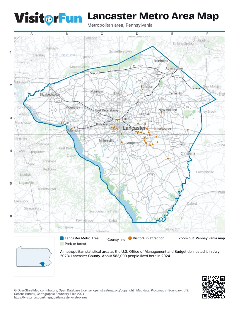
Highway index of Lancaster Metro Area
Each highway on the sheet and the grid squares it crosses.
- I-76B2, C2, D1, D2, E1, E2, F2
- US 30B3, C3, D3, D4, E4, F4
- US 222C3, C4, D2, D3, D4, D5, D6, E1, E2
- US 322C1, C2, D2, E2, E3, F3
- PA 23C3, D3, E3
- PA 41E4
- PA 72C2, C3
- PA 230A2, B2, B3, C3
- PA 241A2, B2
- PA 272C3, C4, D2, D3, D4, D5, D6, E1, E2
- PA 283A2, B2, B3, C3
- PA 324C4
- PA 340D3, E3
- PA 341B2
- PA 372C5, D5
- PA 441B3
- PA 462B3, C3, D3
- PA 501C1, C2, C3
- PA 722C3
- PA 741C3, C4, D4, E4
- PA 743A2, B2, B3
- PA 772B3, C2, D2, D3, E3, E4
- PA 896D3, D4
- PA 897E3
- PA 999C3, C4
Things to do on the Lancaster Metro Area map
- AAA Buggy Rides
- Aaron & Jessica's Buggy Rides
- American Music Theatre
- Amish Country Tours
- Amish Farm and House
- Amish Village
- Barry's Car Barn
- Best Western Intercourse Village Inn & Suites
- Bird-in-Hand Bake Shop
- Bird-in-Hand Farmers Market
- Cherry Crest Adventure Farm
- Choo Choo Barn
- Country Gift & Thrift Shoppe
- DoubleTree Resort by Hilton Hotel Lancaster
- Dutch Wonderland
- Dutch Wonderland Inn
- Eden Resort & Suites
- Family Farm Quilts
- Fashion Cents Consignment
- Fisher's Greenhouse & Garden Center
- Fisher's Harness Shop
- Flory's Cottages & Camping
- Fulton Steamboat Inn
- Fulton Theatre
- George's Furniture
- Gish's Furniture and Amish Heirlooms
- Historic Rock Ford
- Hometown Kitchen
- Jukebox Generation
- Kitchen Kettle Village
- Lancaster City Welcome Center
- LancasterHistory
- Lapp's Toys & Furniture
- Laserdome
- Lost Treasure Golf & Maze
- M & A Sweet Treats
- Miller's Smorgasbord
- North Museum of Nature and Science
- Paradise Station
- Prima Theatre
- Railroad Museum of Pennsylvania
- RB Shap
- Re-Uzit Shop
- Re-Uzit Shop of Ephrata
- Refreshing Mountain
- Ressler Mill Foundation
- Sight & Sound Theatres
- Smucker's Gourd Farm
- Southern Market
- Stoll & Wolfe
- Tanger Outlets Lancaster
- The Old Candle Barn
- The Old Country Store
- The Quilt Shop at Miller's
- Turkey Hill Experience
- Waters Edge Mini Golf
Places on the map
- Adamstown
- Christiana
- Columbia
- East Petersburg
- Eden
- Elizabethtown
- Ephrata
- Gap
- Intercourse
- Lampeter
- Lancaster
- Leola
- Lititz
- Manheim
- Millersville
- Mount Joy
- New Holland
- Reinholds
- Rohrerstown
- Terre Hill
© OpenStreetMap contributors, Open Database License, openstreetmap.org/copyright · Map data: Protomaps · Boundary: U.S. Census Bureau, Cartographic Boundary Files 2024