

Pennsylvania map
Lebanon map
About 26,456 people live here (Census Bureau, 2024 estimate). The sheet's index lists 300 streets; Miller Street, Maple Street and Walnut Street cross the most grid squares. Also on it: Coleman Memorial Park, Lebanon High School and Good Samaritan Hospital.
Open the map (PDF, US Letter)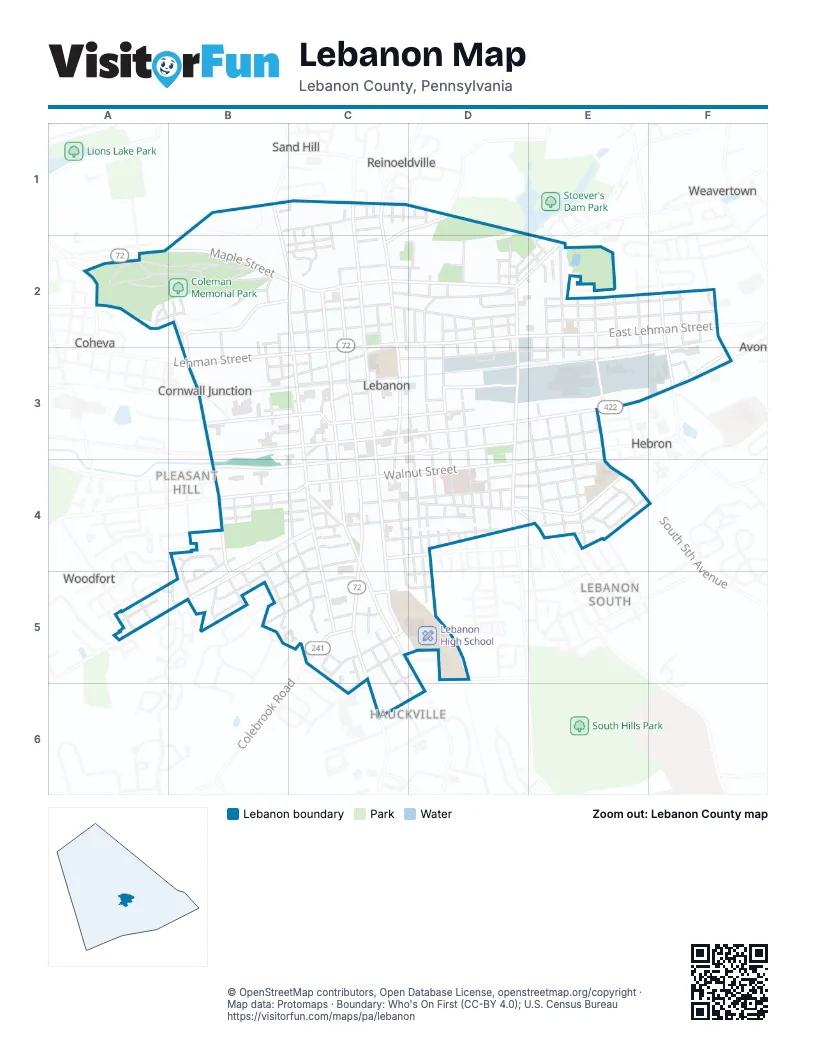
Street index of Lebanon
Each street on the sheet and the grid squares it crosses.
- Maple StreetA2, B2, C2, D2
- Walnut StreetC1, B4, C4, D4
- Cumberland StreetB3, C3, D3
- East Cumberland StreetD3, E3, F3
- North 7th StreetC1, C2, C3
- North 9th StreetC1, C2, C3
- South 12th StreetC3, C4, C5
- North 10th StreetC1, C2, C3
- Quentin RoadC4, C5, C6
- South 10th StreetC3, C4
- South 9th StreetC3, C4
- East Walnut StreetE3, D4, E4
- West Maple StreetA2
- Lehman StreetC2, D2, B3, C3
- East Lehman StreetD2, E2, F2
- North 16th StreetB2, B3
- North 12th StreetC2, C3
- Cornwall RoadC4, C5, D5
- North Lincoln AvenueD2, D3
- South 5th AvenueE3, E4
- South Lincoln AvenueD3, D4
- Colebrook RoadC5
- Jonestown RoadB1, B2, C2
- State DriveD4, E4
- East Maple StreetD2, E2
- North 22nd StreetA2
- Oak StreetB4, C4, D4, B5
- Chestnut StreetC3, D3, B4, C4
- Willow StreetB3, C3, D3
- South 8th StreetC3, C4, C5, D5
- North 8th StreetC1, C2, C3
- Poplar StreetC4, D4, B5, C5
- South 16th StreetB4, B5
- Miller StreetC1, D1, C2, B5, C5
- North 4th StreetD2, D3
- East Pershing AvenueD4, E4
- North 5th AvenueE2, E3
- Old Forge RoadB2, C2
- North 8th AvenueF2, F3
- Hauck StreetC5
- Schneider DriveD3
- York StreetC6, D6
- Wilhelm AvenueD5
- Orange StreetC5, D5
- Old Cumberland StreetC3, F3
- Elm StreetB4, C4, D4, B5
- Guilford StreetC2, D2
- Federal StreetD3, B4, C4, D4
- Spring StreetC3, D3, E3
- Locust StreetC4, D4, A5
- Walton StreetC3, D3
- Crowell StreetC2, D2
- Mifflin StreetB2, C2, D2
- Bashore DriveA2, B2
- Church StreetC2, B3, C3, D3
- East Mifflin StreetE2, F2
- South 6th StreetD3, D4, D5
- East Arnold StreetE2, F2
- North 5th StreetD2, D3
- East Beech StreetD2, E2, F2
- South 7th StreetC3, C4, C5, D5
- Reinoehl StreetB1, C1, D1
- East Weidman StreetE2, F2, D3, E3
- Monument StreetB2, C2
- East Guilford StreetE2, F2
- North Gannon StreetC2, C3
- South 3rd AvenueE3, E4
- Arnold StreetC2, D2
- Mary StreetC2, D2, E2
- North 11th StreetC1, C2, C3
- Canal StreetC2, D2
- Victor StreetB4, C4, B5
- North 3rd AvenueE2, E3
- Weidman StreetC3, D3
- Jones StreetC2, C3
- North 6th StreetC2, D2, C3, D3
- Union StreetC4, D4
- South 3rd StreetD3, D4
- South 1st AvenueE3, E4
- South 13th StreetC4, C5
- East Elm StreetD4, E4
- Sarah StreetC2, D2
- East High StreetD4, E4
- North Partridge StreetC2, C3
- South 2nd AvenueE3, E4
- East Crowell StreetE2, F2
- Scull StreetC3, D3
- South 15th StreetB4, B5
- Peach StreetD2, D3, D4
- South 4th StreetD3, D4
- East Scull StreetF2, E3
- North 2nd AvenueE2, E3
- South 5th StreetD3, D4
- Hill StreetC2, D2
- Pershing AvenueD4
- Greiner StreetC5, D6
- Lafayette StreetB4, C4
- Elder StreetB4, C4
- South 11th StreetC3, C4
- East Chestnut StreetD3, E3
- Nowlen StreetC5, C6
- Canton StreetD3, E3
- Spruce StreetC1, C2, C3
- South 4th AvenueE3, E4
- East Walton StreetD3, E3
- South Gannon StreetC3, C4
- South Partridge StreetC3, C4
- East Locust StreetD4, E4
- South 2nd StreetD3, D4
- North 3rd StreetD2, D3
- Oaklyn RoadB4, B5
- Van Buren StreetB2, B3, C3
- Anges StreetB4, C4
- Florence StreetC4, B5
- North Cherry StreetD2, D3
- Cedar StreetC4, D4
- South 14th StreetB4, B5, C5
- Worden StreetE2
- Chinkapin StreetD3, E3
- Washington StreetB4, C4
- Alder StreetD2, D3
- Beech StreetD2, D3
- Vine StreetC5, D5
- South Cherry StreetD3, D4
- Linden StreetC4, D4
- Woodland StreetB5, C5
- Brandywine StreetB3, C3
- Plum StreetC1, D2, D3, D4
- South Liberty StreetC3, C4
- Schroff DriveA2
- East Federal StreetD3, E3
- Bollman StreetC2, C4, D4, D5
- Noble StreetD4
- Decatur StreetB1, C2, C3
- North 7th AvenueE2
- North 4th AvenueE2, E3
- North 14th StreetB2, B3
- New StreetD2, D3
- South Quince StreetD3, D4
- Emma StreetC4, C5
- North 6th AvenueE2, E3
- Forry StreetC5
- North 1st StreetD2, D3
- Hornet StreetC2, D3
- Ehrgood DriveA2
- East Sarah StreetD2, E2
- North 9th AvenueF2
- Lebanon VillageF2
- Meily StreetB2, C2, E3
- Hazel StreetC4, D4
- Rita LaneB4, B5
- Maple AvenueD1, D2
- North 2nd StreetD2, D3
- Hillside StreetC4
- Pine StreetC4, D4
- Derry StreetC5, D5
- Hanover StreetD2, D3
- Beechwood AvenueE4
- Libby StreetC4
- Madison StreetB3, C3
- Nancy LaneC5, C6
- Adams StreetC2, B3
- Murray StreetC3
- East Poplar StreetE4
- Water StreetC2
- Amelia StreetC2, D2
- Birch StreetD3, E3
- Steitz StreetB4, B5
- Steckbeck StreetB2, C2
- Cherry StreetC1, B2, C2, D2
- South Bollman StreetC3, C4
- Monroe StreetB2, B3
- Magnolia AvenueD1, D2
- Centre AvenueD2
- North 11th AvenueF2, F3
- North Quince StreetD2, D3
- Furnace Hill RoadB2
- Clover StreetC3, D3
- East Grant StreetE4
- North 13th StreetB2, B3
- Kline StreetA5
- Park DriveB5
- Roosevelt AvenueD2
- North Hanover StreetD2, D3
- Broad StreetD4
- Duke StreetC5
- South Broad StreetD4, D5
- Worth StreetD4
- Frickr DriveA2, B2
- South Prune StreetD3, D4
- Tow Path WayB2
- Boyer StreetD2
- Unler StreetB3, C3
- C&L StreetC3
- Summit StreetC5, D5, C6
- Creekside DriveB5
- Tiffany LaneD2
- Woodland EstatesC5
- East Pine StreetE4
- East Canal StreetE2
- Harrison AvenueD2, D3
- Steel StreetB2
- Jackson StreetB3, C3
- Liberty StreetC2, C3
- Jackson BoulevardC5
- Shirley DriveE4
- Bowman StreetF3
- Chapel StreetC2
- Robin RoadB5
- Perry AlleyC4, D4
- Martin StreetC5
- Fern StreetC4, D4
- North Prune StreetD2, D3
- Abbey StreetC5, C6
- Blueberry LaneA2
- Ream StreetE4
- Klopp DriveA2
- Krause DriveB2
- Greentree VillageC5, C6
- South 22nd StreetA5
- Berry LaneA2, B2
- Donough DriveA2
- South 21st StreetA5
- Concentrator RoadB2, B3
- Brock DriveC2
- Althea AvenueD1, D2
- Olive StreetE2
- Shuey StreetB3, C3
- Parr StreetE2
- Porter StreetE2, E3
- Edison StreetC1, C2
- Reber StreetC5
- Donmoyer StreetC2
- Kreider DriveB2
- North 10th AvenueF2
- Walnut AlleyA5
- Bittner BoulevardB3, C3
- Harding StreetC1
- Apple StreetD4
- Palm StreetD4
- Kreider StreetC5
- North Plum StreetD2, D3
- Thru StreetC5
- Catherine StreetC2
- Aspen StreetB4
- Larch StreetB4
- Berwyn ParkD4
- North 1st AvenueE2, E3
- Dale StreetB3
- Dodge StreetC1
- Laurel StreetC4, C5
- Reno StreetD2
- East Linden StreetD4, E4
- Farraday StreetF2
- Glenwood StreetC2
- Myrtle AvenueD1, D2
- Zimmerman StreetD2
- Greth StreetD4
- Pear StreetD4, E4
- Park AvenueD4
- Humbolt StreetF2
- Cypruss AvenueD1, D2
- Eby StreetE3
- East Spring StreetE3
- Dawson StreetB5, C5
- East Vine StreetE4
- Krim CourtB4, B5
- Coleman CircleC2
- Black StreetC2, D2
- North Liberty StreetC3
- Penn StreetB4, C4
- Battie StreetC4
- Daniel StreetE2
- Partridge StreetC3
- Baldwin StreetD1
- Dandelion StreetC5, D5
- South 1st StreetD4
- Woodward StreetC1
- Hathaway ParkD4
- Stover StreetE2
- Green StreetD3
- Elizabeth StreetC4
- Centre StreetD2
- 20th StreetA2
- Tyler StreetD2
- Cathedral StreetC1
- Frantz StreetC5
- Ruth StreetC4
- Light AvenueC2
- Raspberry LaneB2
- East Kline StreetE2
- Freeman StreetB2, B3
- Green LaneB4
- Jadell DriveE4
- Center StreetB4
- Hoffman StreetE3
- Taylor StreetD4
- Tabor StreetC4
- Hoke AvenueD4, E4
- Goose StreetB3
Places on the map
- ALDI
- Assumption of the Blessed Virgin Mary
- AutoZone
- Beautex Playground
- Calvary Chapel
- Carriage House Car Wash
- Chestnut Street Community Center
- Coleman Memorial Park
- Days Inn - Lebanon / Hershey
- Extremities Entertainment
- Eyeland Optical
- Fair's Barber Shop
- Fine Wine & Good Spirits
- First National Bank
- Fisher Veterans' Memorial Park
- Fulton Bank
- Giant
- Good Samaritan Hospital
- Hebron United Methodist Church
- Hill Top Playground
- Houck Elementary School
- Ideal Food Basket
- Iglesia Pentecostal Arca De Noe
- Jonestown Bank & Trust Co. (JBT)
- LCBC
- Lebanon City Hall
- Lebanon Community Library
- Lebanon County Courthouse
- Lebanon High School
- Lebanon Middle School
- Lebanon Seventh-Day Adventist Church
- Lebanon Valley Family YMCA
- Louser Memorial Park Northeast
- Louser Memorial Park Southwest
- McDonald's
- Monument Park
- New Life Mennonite Fellowship
- Old School Electronics
- Southeast Elementary School
Next to Lebanon
- Avon
- Coheva
- Hauckville
- Hebron
- Lebanon South
- Pleasant Hill
- Reinoeldville
- Sand Hill
- Weavertown
- West Lebanon
- Woodfort
© OpenStreetMap contributors, Open Database License, openstreetmap.org/copyright · Map data: Protomaps · Boundary: Who's On First (CC-BY 4.0); U.S. Census Bureau















