

Pennsylvania map
Middle Smithfield Township map
About 15,922 people live here (Census Bureau, 2024 estimate). The sheet's index lists 300 streets; Coolbaugh Road, Resica Falls Road and Marshalls Creek Road cross the most grid squares. Also on it: East Stroudsburg Reservoir, Hidden Lake and Lake Monroe.
Open the map (PDF, US Letter)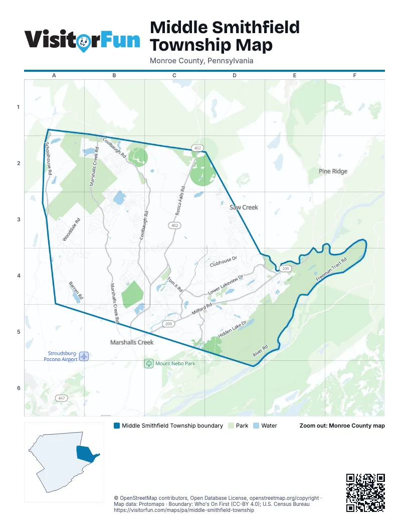
Street index of Middle Smithfield Township
Each street on the sheet and the grid squares it crosses.
- Milford RoadD4, E4, C5, D5
- Resica Falls RoadC2, C3, C4, B5, C5
- Route 402 RoadC2
- Marshalls Creek RoadB1, B2, B3, B4, B5
- Coolbaugh RoadB2, C2, B3, C3, B4, C4
- Schoolhouse RoadA1, A2, A3
- Lower Lakeview DriveC4, D4
- Sellersville DriveD3, C4, D4, C5
- Hollow RoadC5
- Tom X RoadC4
- Winona Falls RoadD4, E4
- River RoadE4, D5, E5, D6
- Hidden Lake DriveE4, C5, D5, E5
- Clubhouse DriveD3, D4
- Big Ridge DriveC4, C5
- Freeman Tract RoadF3, E4, F4, E5
- Wooddale RoadA3, B3, A4
- Firestone LaneC2, C3
- Hiawatha LaneB1, A2, B2
- Pocono DriveA4, B4
- Barren RoadA4
- Timothy Lake RoadD3
- Upper Lakeview DriveC4, D4
- Church Hill RoadD5, E5
- Brushy Mountain RoadA4, B4, A5, B5
- Great Bear Way RoadD5
- Fruchey RoadC5
- Oak Grove DriveC5
- Park DriveC4, D4
- Scarborough WayD2, D3
- Otter Lake RoadA2, B2
- Keystone RoadD4, D5
- Tego Lake RoadB3
- Mosiers Knob RoadD5
- McCole RoadD4, D5
- Dancing Ridge RoadA3, A4
- Community DriveE4
- Alpine DriveD4
- Denise LaneA3, A4
- Rising Meadow WayD5
- Reservoir RoadA4, A5
- Frontier RoadB2
- Stony Creek RoadD4
- Turkey Ridge RoadC4, D4
- Lakeshore Drive EastB3
- Sierra Trails DriveA3
- Sky Hawk TrailB3
- Michaels RoadD5
- Bear Swamp RoadB3
- Bristol Circle EastB3
- Pocono Forested DriveB2, B3
- Westminster DriveB3
- Fantasy RoadD4
- Appalachian TrailD3
- Fairway Villas BoulevardD4, E4
- White Dove DriveB3, C3
- Castle DriveC3, C4
- Waverly DriveA3
- Arrowhead LaneB2
- Fenical LaneD4, D5
- Big Buck LaneA3
- Big Winona RoadE4
- Lake Roger RoadC2, C3
- Bristol Circle WestB3
- White Heron Lake DriveB4, B5
- Primrose LaneC5
- Rue de JohnA4
- Norman DriveD3, D4
- Trafalgar AvenueB3
- Kahkout Mountain CircleD4
- Deer Track DriveB4
- Sweet Water LaneB3
- Vista CircleD3, D4
- Woodcrest DriveD4
- Yukon DriveC4, D4
- Rocky Ridge RoadB3
- Georganna DriveA3
- Kingbird TrailE4
- Besecker DriveB3
- Courtright LaneC3
- Shawnee DriveD3
- Mountain Top RoadD3
- Woodland TrailA4
- Wilbur Bloom BoulevardD4
- Heights DriveB4
- Pine Valley WayC4
- Hutson HillB4, B5
- Edward Smith BoulevardD4
- Canal RoadB4, B5
- Lakeshore Drive WestB2, B3
- Cold Springs RoadC4
- Eagle DriveC4
- Doral CourtC4
- Mansion LaneE4
- Northslope II RoadC5
- Shady Hill RoadB4
- Maplewood DriveA3
- Country Creek LaneD4
- Sanctuary DriveB2
- Murray Hill RoadC5
- Municipal DriveD4, D5
- Leisure Lands RoadB2
- Robin LaneB4
- Sleepy Hollow LaneC5, D5
- Gingerbread LaneB2
- Columbia BoulevardC5
- Carnation RoadB3
- Majestic CourtC4
- Timber Mountain DriveC2
- Sumner DriveB2
- Carol RoadD3
- Daffodil RoadB3
- Pardees LoopC5
- Farview DriveB4
- Dawn AvenueA4
- Main RoadB3
- Haven Wood DriveA3
- Gravel Ridge RoadC4
- Huckleberry DriveD4, D5
- Waterview CircleE4
- Lee RoadA4
- Kansa RoadD4
- Empty LaneC5
- Fringe DriveC4
- Mountainside BoulevardE4
- Rolling Hills DriveC4
- Timber DriveC3, C4
- Lace DriveA3, A4
- Jennifer LaneA3, A4
- Gallahad PassD3, D4
- Northpark Drive WestD4, D5
- Squirrel Hill DriveC4
- Stratton DriveC5
- R Own RoadC4
- Dry Pond DriveA4, B4
- Masons LaneB4
- Boyer RoadB4, C4
- Sunset RoadB2, B3
- Snowshoe TrailB2
- Hilltop CircleD3
- Sycamore LaneB3, C3
- Russell Ridge RoadB5, C5
- Rock RoadC3, C4
- Road MA2
- Heron Woods RoadB5
- Arctic DriveC3, C4, D4
- Sand Hill RoadE4
- Waterslide WayD2, D3
- William DriveC3
- Green Mountain DriveC3
- Papoose DriveD3
- Elderberry LaneB2
- Westlake DriveC5
- Autumn CourtD4
- Northpark Drive EastD4, D5
- Calvary CourtC5
- Homestead LaneD3
- Parliament DriveB3
- Springmeadow BoulevardE4
- Lincoln RoadD4
- Marjorie CourtC2
- Edelweiss RoadB3
- Panda LaneB2
- Lake of the Pines Boulevard NorthD4
- Little Bear LaneB2
- Reservoir Ridge RoadA4, B4
- Bellingham DriveD3
- Ledgewood CourtA4
- Dependent DriveB4, B5
- Crabapple LaneC5
- Hikers DriveA3
- Melvin LaneA4
- Skyview DriveC5
- Wellington WayD3
- Lumberjack DriveB2
- Wintergreen RoadB2
- Delilah RoadB3
- Knoll DriveA3, A4
- Adirondac DriveD3
- Pines DriveE4
- Aster RoadB3
- Cone RoadB3
- Prairie LaneC4, C5
- Walker RoadB4, C4
- Faratol RoadB3
- Forest Lake DriveD4
- Birchwood DriveD4
- Hannan LaneB3
- May LaneC5
- Squires DriveD4
- Azalea WayB3, C3, C4
- Clearview DriveD4
- Deer Path DriveA3
- Longview DriveD4
- Rangoon LaneE4
- Pennsylvania AvenueB4
- Flagstone LaneB2
- Creek RunB3
- White Birch LaneB5, C5
- Allegheny LaneD3
- Sundance RoadD4
- Hillcrest CircleE4
- Chateau DriveC3, C4
- Bluegill StreetD2, D3
- Turkey Foot TrailB2
- Horning RoadB3
- Lake of the Pines Boulevard SouthD4
- Big Bear DriveA3
- Sports Camp RoadC4
- Sheriff LaneC4
- Service RoadC5, D5
- Pinewood Drive NorthD4
- AC RoadB2
- Granite RoadB3
- Begonia RoadB3
- Chamberlain DriveB3
- Eastridge LaneA3
- Hickory DriveB2
- Adventure DriveB3
- Spruce LaneB2
- Stony Brook DriveB4, C4
- Birch RoadB3
- Pine Ridge Road NorthD4
- Rim RoadD3
- Tower DriveC3, C4
- Mount Nebo RoadC5
- Auburn WayA3
- High Meadow DriveA3
- Payton RoadB5
- Angler StreetD2
- Ash RoadB3
- Milestone DriveC5, D5
- Jackson DriveB5
- Morris RoadB3
- Craigs Meadow RoadB5
- Cotton Tail LaneB2
- Allen RoadB4
- Pine Ridge Road SouthD4
- Honeysuckle DriveA3
- Trader RoadB2, B3
- Slope RoadB4, B5
- Sterling CourtD4, D5
- Elmhurst RoadB3
- Cardinal LaneD4
- Trailblazer StreetD2, D3
- Saint Andrews DriveD3
- Penny LaneB4
- Marco WayC4, C5
- Laurel Ridge RoadC3, B4, C4
- Totteridge RoadD3
- Gander RoadB3
- New Jersey DriveD3
- Pattis LaneD5
- Wagon Trail RoadC5
- Harper LaneB3, C3
- Honeycomb LaneB4
- Bridge Port LaneB5
- Dornick RoadB3
- Lynwood DriveB4
- Mountain Laurel DriveA3
- Century DriveD5
- Valley DriveC3
- Ahnert WayE4
- Ranger RoadB4
- Upper PMHE North DriveB4
- Warehouse DriveE4
- Howeytown RoadC2
- Courtney DriveD5
- Elm RoadB3
- Mackenzie DriveB3
- Chancellor RoadB3
- Champagne LaneD4
- Glacier DriveB2
- Talisman DriveB3
- Castor RoadB3
- Holy Cross RoadC5
- Spyglass CourtC4
- Freedom RoadB2
- Manzanedo RoadA3
- Bunny TrailB5
- Fir RoadB3
- Norman CourtD4
- Pine Hill RoadB4
- Jag RoadE4
- Lynn RoadB5
- Sequoia DriveB2
- Fairway LaneD5
- Skyview LaneB4, C4
- Bridge Side DriveD4
- Huffman Hill RoadB5
- Spa CourtC4
- Cross RoadB3
- Racoon LaneB2
- Swan CourtD5
- Grey Cliff DriveD5
- Sugar Works DriveB4
- Lower PMHE North DriveB4
- Yale CourtC5
- Lower PMHE South DriveB4, C4
- Camp RoadC2
Places on the map
- AutoZone
- Beaver Lake
- Bushkill Village Trailhead
- Cool Dip
- Coolbaugh Community Gardens Park
- Coolbaugh Lake
- Country Club of the Poconos Municipal Golf Course
- Country Club of the Poconos North Courts
- Deer Lake
- East Stroudsburg Reservoir
- Echo Lake
- Echo Lake Park
- Fox Run Plaza
- Great Bear Golf Club
- Hiawatha Lake
- Hidden Lake
- Judy Putek Memorial Park
- Kahkhout Mountain
- Lake Ann
- Lake Monroe
- Lake Roger
- Meadow Lake
- Otter Lake
- Otter Lake Camp Resort
- Pine Mountain
- Pipher's Pond
- Pocono Bazaar
- Pocono Heights Park
- Pocono Highlands Lake
- Pocono TreeVentures
- Resica Falls Scout Reservation
- Resica Park
- Retro Plaza
- Sand Hill Cemetery
- Timothy Lake
- Timothy Lake North
- Timothy Lake South
- Tims Swamp
- Werry Lake
- White Heron Lake
Next to Middle Smithfield Township
- Marshalls Creek
- Pine Ridge
- Saw Creek
© OpenStreetMap contributors, Open Database License, openstreetmap.org/copyright · Map data: Protomaps · Boundary: Who's On First (CC-BY 4.0); U.S. Census Bureau















