

Pennsylvania map
Northampton County map
About 322,989 people live here (Census Bureau, 2024 estimate). The sheet's index lists 157 streets; Main Street, North Delaware Drive and Easton Road cross the most grid squares. Things to do inside the boundary: Lost River Caverns.
Open the map (PDF, US Letter)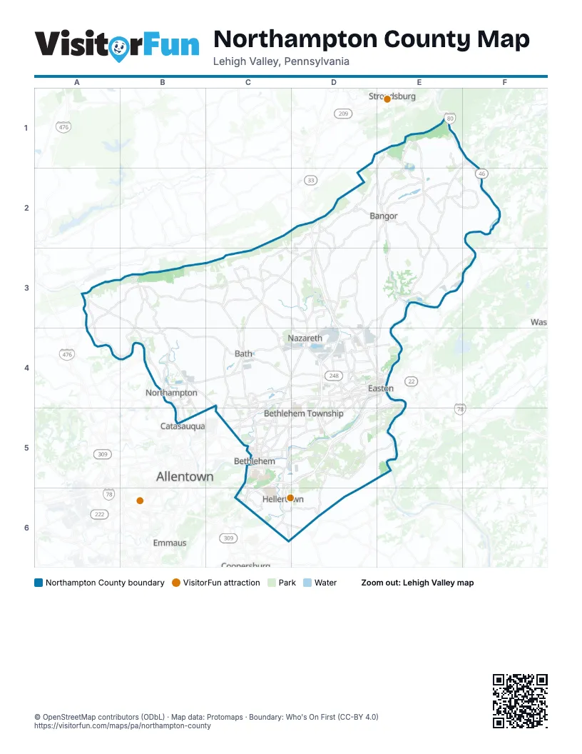
Street index of Northampton County
Each street on the sheet and the grid squares it crosses.
- North Delaware DriveE1, F1, E2, E3, E4
- Valley View DriveE1, E2
- Delaware AvenueF1, C5
- Portland-Columbia BridgeF1
- Blue Valley DriveD2
- BroadwayD2, D3, C5
- Broadway (Old Route 115)D2
- East Main StreetD2
- East Pennsylvania AvenueD2
- Market StreetD2, E2
- North Lehigh AvenueD2
- Old Route 115D2
- Park AvenueD2, D4
- Sullivan TrailD2, D3, D4
- Washington BoulevardD2, E2, D3
- West Pennsylvania AvenueD2
- Lower South Main StreetE2, E3
- Messinger StreetE2
- Mount Bethel HighwayE2
- North 1st StreetE2
- Roseto AvenueE2
- South 1st StreetE2
- South Delaware DriveE2, E3, E4, E5
- South Main StreetE2
- Lehigh DriveA3, B3, B4
- Main StreetA3, D3, E3, B4, D4, B5, C5, D5, C6
- North Best AvenueA3
- Riverview DriveA3, A4, B4
- South Best AvenueA3, A4
- West Mountain View DriveA3, B3
- Mountain View DriveB3, C3
- Bushkill Center RoadC3, D3, D4
- Community DriveC3
- East Moorestown RoadC3, D3
- Monocacy DriveC3, C4
- Moorestown DriveC3, C4
- Moorestown RoadC3
- Nazareth DriveC3, C4
- West Moorestown RoadC3
- Bangor RoadD3
- East Lawn RoadD3, D4
- Industrial BoulevardD3
- Kesslersville RoadD3, D4
- PA-33D3, D4, D5
- Uhler RoadD3, E3, D4
- Front StreetE3, B5
- Martins Creek Belvidere HighwayE3, F3
- Riverton-Belvidere BridgeF3
- 21st StreetB4
- East 21st StreetB4
- Nor-Bath BoulevardB4, C4
- Pheasant DriveB4, C4
- Weaversville RoadB4, C4, C5
- Airport RoadC4, C5
- Bath PikeC4, D4, C5
- Beth Bath PikeC4
- Beth-Bath PikeC4
- Chestnut StreetC4
- Daniels RoadC4, D4
- East Northampton StreetC4
- Lehigh Valley ThruwayC4, D4, E4, C5
- Nazareth PikeC4, D4, C5
- North Chestnut StreetC4
- North Walnut StreetC4
- Race StreetC4
- West Main BoulevardC4
- West Main StreetC4
- West Northampton StreetC4
- 25th StreetD4, D5
- Bushkill DriveD4
- Butler StreetD4
- East Center StreetD4
- East Walnut StreetD4
- Easton RoadD4, C5, D5, E5, C6
- Easton-Nazareth HighwayD4
- Freemansburg AvenueD4, C5, D5
- Hackett AvenueD4
- Knox AvenueD4, E4
- Lafayette StreetD4, E4
- Nazareth RoadD4
- North 13th StreetD4
- North 7th StreetD4
- North Broad StreetD4
- North Broad Street ExtendedD4
- North New StreetD4, C5
- Northampton StreetD4, E4
- Old Nazareth RoadD4
- Pearl StreetD4, E4
- Prospect AvenueD4
- Sales StreetD4
- South 13th StreetD4
- South 25th StreetD4
- South 8th StreetD4
- South Broad StreetD4
- Sullivan Trail (Old Route 115)D4
- Tatamy RoadD4
- Washington StreetD4, E4
- William Penn HighwayD4, E4, D5
- Wolf AvenueD4
- Wood AvenueD4
- 3rd StreetE4
- Bushkill StreetE4
- Cattell StreetE4
- Cedarville RoadE4, E5
- Centre SquareE4
- College AvenueE4
- Interstate 78 Toll BridgeE4, E5
- Larry Holmes DriveE4
- Morgan Hill RoadE4, D5, E5
- North 3rd StreetE4
- North Riverside DriveE4
- North Smith AvenueE4
- Northampton Street BridgeE4
- Old Philadelphia RoadE4
- Phillipsburg-Newark ExpresswayE4, E5
- Saint John StreetE4
- Snyder StreetE4
- South 3rd StreetE4
- 2nd StreetB5
- 4th StreetB5
- Cypress StreetB5
- Eugene StreetB5
- Lehigh StreetB5
- 2nd Street RampC5
- Brodhead AvenueC5
- Center StreetC5
- Daly AvenueC5
- East 3rd StreetC5
- East 4th StreetC5
- East Broad StreetC5
- East Church StreetC5
- East Elizabeth AvenueC5
- East Goepp StreetC5
- East Union BoulevardC5
- Easton AvenueC5, D5
- Fahy BridgeC5
- Hellertown RoadC5
- Hill to Hill BridgeC5
- Linden StreetC5
- PA-378C5, C6
- Pembroke RoadC5
- Schoenersville RoadC5
- Stefko BoulevardC5
- West 3rd StreetC5
- West 4th StreetC5
- West Broad StreetC5
- West Church StreetC5
- West Elizabeth AvenueC5
- West Union BoulevardC5
- Willow Park RoadC5
- Wyandotte StreetC5
- Gene Hartzell Memorial BridgeD5
- Island Park RoadD5
- Lower Saucon RoadD5
- Raubsville RoadD5, E5
- Apples Church RoadC6
- Leithsville RoadC6, D6
Things to do on the Northampton County map
Places on the map
- Albert Ponds Preserve
- Allen Township
- Archibald Johnston Conservation Area
- Ballas Meadow Preserve
- Bangor
- Bangor Area High School
- Bangor Memorial Park
- BAPS Shri Swaminarayan Mandir
- Bath
- Becky's Drive-In
- Belfast
- Bethlehem Earth
- Bethlehem Landfill
- Bethlehem Plaza
- Bethlehem Square
- Bethlehem Township
- Bicentennial Park
- Black River Farms
- Bodnarczuk Tract
- Braden Airport Runway
- Bushkill Township
- Bushkill Township Recreation Center
- Calpine Bethlehem Energy Center
- Canal Street Park
- Catasauqua High School
- Central Bethlehem
- Chapman
- Chrin Brothers Landfill
- Chrinergy Park
- Clairmont Avenue
- Country Inn Estates
- Country Squire Estates
- Countryside Trails
- Creekside Marketplace
- Delaware Quarries - Riverton
- Delps Park
- Driftstone Campground
- Dutch Springs
- East Allen Gardens
- East Allen Township
Next to Northampton County
- Allentown
- Catasauqua
- Coopersburg
- Emmaus
- Lopatcong Township
- Stroudsburg
© OpenStreetMap contributors (ODbL) · Map data: Protomaps · Boundary: Who's On First (CC-BY 4.0)