

Pennsylvania map
State College map
About 41,228 people live here (Census Bureau, 2024 estimate). The sheet's index lists 286 streets; University Drive, South Garner Street and South Atherton Street cross the most grid squares. Things to do inside the boundary: Happy Valley.
Open the map (PDF, US Letter)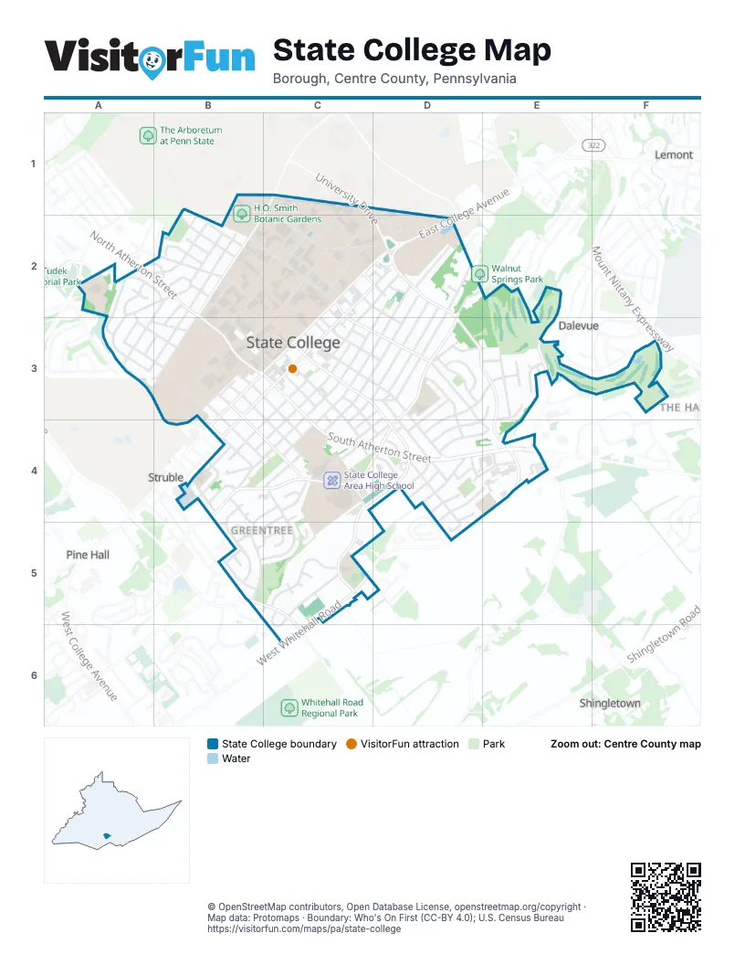
Street index of State College
Each street on the sheet and the grid squares it crosses.
- Bigler RoadB1, C1, C2
- Curtin RoadC1, B2, C2, B3
- East Park AvenueC1, B2
- Softball Stadium DriveC1
- University DriveC1, D2, D3, E3, E4
- Hastings RoadD1, C2, D2
- Serviceberry RoadD1, D2
- Fairway RoadA2, A3, B3
- Glenn RoadA2, A3
- Martin StreetA2
- Martin TerraceA2, B2
- North Atherton StreetA2, B2, B3
- North Glenn CircleA2
- Oak StreetA2
- Orlando AvenueA2, A3
- South Glenn CircleA2
- Taylor StreetA2, B2
- West Cherry LaneA2
- West Mitchell AvenueA2, B2
- Willard StreetA2, B2
- Adams AvenueB2
- Ag Hill DriveB2
- Allen RoadB2
- Arbor WayB2, B3
- August AlleyB2
- East Mitchell AvenueB2
- Ferguson AvenueB2
- Fischer RoadB2
- Fraser RoadB2, C3
- Hartswick AvenueB2
- Hillcrest AvenueB2, A3
- Holmes StreetB2
- Jackson CircleB2
- Jackson StreetB2
- Lehman WayB2
- McKee StreetB2
- North Allen StreetB2
- North Burrowes StreetB2
- November AlleyB2
- October AlleyB2
- Ridge AvenueB2, A3, B3
- River Birch RoadB2
- Shortlidge RoadB2, C2
- Thomas StreetB2
- West Park AvenueB2, A3, B3
- Willard CircleB2
- Woodland DriveB2
- Bluestar WayC2
- East Beaver AvenueC2, D2, C3
- East Calder WayC2, C3
- East College AvenueC2, D2, C3
- East Foster AvenueC2, D2, C3
- Eisenhower RoadC2
- Elm RoadC2, D2
- Henderson DriveC2
- Hetzel StreetC2, D2, D3
- Hiester StreetC2, C3
- High StreetC2, D2
- Keller StreetC2, D2
- Linden RoadC2
- Lionheart DriveC2
- Locust LaneC2, C3, D3
- McKean RoadC2
- Mifflin RoadC2
- Millennium DriveC2
- Old Coaly WayC2
- Peach AlleyC2
- Pollock RoadC2, B3, C3
- Scholarship DriveC2, D2
- Science DriveC2
- South Garner StreetC2, C3, D3, D4, E4
- Sowers StreetC2
- Wilson AlleyC2
- Bellaire AvenueD2
- East Fairmount AvenueD2, C3
- East Hamilton AvenueD2, C3, D3
- East Irvin AvenueD2, C3, D3
- East McCormick AvenueD2, D3
- East Prospect AvenueD2, C3, D3
- East Waring AvenueD2, D3
- Effluent RoadD2
- Fox AlleyD2, D3
- Glenn AlleyD2
- Holly AlleyD2, C3
- Holly CourtD2
- Oak RoadD2
- Redgate LaneD2
- Redgate RoadD2
- Ringneck RoadD2
- Walnut Spring LaneD2, E2, D3
- Water Reclamation DriveD2
- Wolf AlleyD2
- Country Club RoadE2, E3
- East Branch RoadE2, E3, E4
- Oak Ridge AvenueE2
- Shamrock AvenueE2
- Timber LaneE2
- Clarence AvenueA3, B3
- Franklin StreetA3, B3
- Sunset RoadA3, B3
- Westview AvenueA3
- Clay LaneB3
- Coal AlleyB3
- Duff DriveB3, B4
- Grass AlleyB3
- H AlleyB3, C3, C4
- Highland AlleyB3, C3, B4
- Homecoming DriveB3, C3
- I AlleyB3, C3
- Lark AlleyB3
- North Barnard StreetB3
- North Burrowes RoadB3, C3
- North Gill StreetB3
- North Patterson StreetB3
- North Sparks StreetB3
- Orange AlleyB3
- Power Station RoadB3
- Railroad AvenueB3
- Semester DriveB3
- Shade WayB3, B4
- South Atherton StreetB3, C3, C4, D4, E4
- South Barnard StreetB3, C3, C4
- South Gill StreetB3, C4
- South Patterson StreetB3, B4
- South Sparks StreetB3, B4, C4
- Steam DriveB3
- Thorn AlleyB3
- Thrush AlleyB3
- West Beaver AvenueB3, C3, B4
- West Calder WayB3, C3, B4
- West Campus DriveB3, B4
- West College AvenueB3, C3, B4
- White Course DriveB3
- Wood AlleyB3
- A AlleyC3
- Apple AlleyC3, D3
- Ash AlleyC3
- B AlleyC3
- Berry AlleyC3, D3
- Birch AlleyC3
- Bird AlleyC3
- C AlleyC3, D3
- Chestnut AlleyC3
- Clover AlleyC3, D3
- Cresson AlleyC3
- D AlleyC3
- Daisy AlleyC3, C4
- E AlleyC3
- East Nittany AvenueC3
- Elk AlleyC3, D3
- Elm AlleyC3, D3
- F AlleyC3
- Foundry Park RoadC3
- Fraternity RowC3
- G AlleyC3
- Hawk AlleyC3, C4
- Highland AvenueC3
- Hill AlleyC3, C4
- Hole AlleyC3
- Humes AlleyC3
- Kelly AlleyC3
- Laurel AlleyC3
- Lytle AlleyC3, C4
- McAllister AlleyC3
- McAllister StreetC3
- Miller AlleyC3
- New AlleyC3
- Old Boalsburg RoadC3, D3, D4
- Orchard AlleyC3, B4
- Osage AlleyC3, D3
- Robin AlleyC3
- South Allen StreetC3, D3, D4, D5
- South Burrowes StreetC3, C4
- South Fraser StreetC3, C4
- South Pugh StreetC3, D3, D4
- Sparrow AlleyC3, C4
- Walnut StreetC3, C4, D4
- West Fairmount AvenueC3, B4, C4
- West Foster AvenueC3, B4
- West Hamilton AvenueC3, C4
- West Irvin AvenueC3, C4
- West Nittany AvenueC3, B4, C4
- West Prospect AvenueC3, C4
- Wren AlleyC3
- Crestmont AvenueD3, C4
- Easterly ParkwayD3, D4
- Ellen AvenueD3, D4
- Iris AlleyD3, C4
- Kemmerer RoadD3
- Legion LaneD3, E3
- Logan AvenueD3, C4
- Nimitz AvenueD3, E3, D4
- Oak AlleyD3
- Pearson AlleyD3
- Rosa LaneD3
- Smithfield CircleD3
- Smithfield StreetD3
- Stony LaneD3, E3
- Stuart StreetD3
- William StreetD3, D4
- Colonial CourtE3
- Homan AvenueE3, D4, E4
- North Inverary PlaceE3
- Penfield RoadE3
- Royal CircleE3
- Royal RoadE3
- Sandpiper DriveE3
- Sawgrass CircleE3
- South Inverary PlaceE3
- Bayberry DriveB4, C4, B5
- Crabapple CourtB4
- Crabapple DriveB4, B5
- Dorum AvenueB4
- Hadden CourtB4
- Harley AlleyB4
- Hedgerow DriveB4, B5
- Hoy StreetB4
- K AlleyB4, C4
- L AlleyB4
- M AlleyB4
- Metz AvenueB4
- N AlleyB4
- North Buckhout StreetB4
- Robin RoadB4
- South Buckhout StreetB4
- South Butz StreetB4
- South Corl StreetB4
- South Osmond StreetB4
- West Highland AvenueB4
- Westerly ParkwayB4, C4, D4
- Hill Alley ExtensionC4
- Marigold AlleyC4, D4
- O'Bryan LaneC4
- Piersol LaneC4
- Plaza DriveC4
- Saxton DriveC4, B5, C5
- Storch RoadC4
- Sunrise TerraceC4, D4
- Waupelani DriveC4, D4, C5
- Webster DriveC4, B5, C5
- Windsor CourtC4
- Aikens PlaceD4
- Bradley AvenueD4, E4
- Center LaneD4
- East Doris AvenueD4, E4
- East Lytle AvenueD4
- East Marylyn AvenueD4, E4
- East South Hills AvenueD4
- East Whitehall RoadD4
- Fry DriveD4
- Hutchison WayD4
- Norma StreetD4
- Oneida StreetD4
- Waypoint CircleD4
- West Doris AvenueD4, D5
- West Lytle AvenueD4
- West Marylyn AvenueD4
- West South Hills AvenueD4
- West Whitehall RoadD4, C5
- Joyce DriveE4
- Science StreetE4
- Suzy CircleE4
- Vivian WayE4
- Woodsdale LaneE4
- Amelia AvenueB5
- Barley WayB5
- Bayfield CourtB5, C5
- Blue Course DriveB5, C5, C6
- Grace StreetB5
- Lillian CircleB5
- Thistlewood WayB5
- Wintergreen CircleB5
- Campbell RoadC5
- Edgewood CircleC5
- Greenfield CircleC5
- Hart CircleC5
- Highlandon CourtC5
- North Ashwicken CourtC5
- Roundhay CourtC5
- South Ashwicken CourtC5
- Southgate DriveC5
- Stratford CourtC5, C6
- Stratford DriveC5
- THON DriveC5
- Wheatfield DriveC5
- Oakhurst LaneD5
Things to do on the State College map
Places on the map
- 83 West Resident Student Lots
- Albright-Bethune United Methodist Church
- Alpha Fire Company
- Alpha Rho Chi Event Backyard
- Alpha Zeta
- Aone Mart
- Architecture and Landscape Architecture Library
- Atherton St Depot
- Balfurd Cleaners
- Barnes & Noble
- Bastian Tire & Auto Center
- Beaver Avenue Garage
- Bee and Pollinator Garden
- Beecher-Dock House
- Centre Hills Country Club
- Community Field
- Earth and Mineral Sciences Library
- Foxdale Village
- H.O. Smith Botanic Gardens
- High Point Park
- Highlands Historic District
- Holmes-Foster Park
- Holuba Hall
- Hort Woods
- Lederer Park
- Marsh Meadow
- Millennium Lawn
- Orchard Park
- Ramada State College
- Schwab Auditorium
- State College Area High School
- State College Friends School
- Sunset Park
- The Terrace at Brookline
- The UPS Store
- University Park Post Office
- Westerly Parkway Plaza
Next to State College
- Canterbury Crossing
- Dalevue
- Lemont
- Pine Hall
- Shingletown
- Struble
- The Hamlet
© OpenStreetMap contributors, Open Database License, openstreetmap.org/copyright · Map data: Protomaps · Boundary: Who's On First (CC-BY 4.0); U.S. Census Bureau















