

Pennsylvania map
Stroud Township map
About 19,600 people live here (Census Bureau, 2024 estimate). The sheet's index lists 300 streets; Paradise Trail, Cherry Valley Road and Chipperfield Drive cross the most grid squares. Also on it: Arlington Heights, Cranberry Run Campground and Glen Brook Golf Club.
Open the map (PDF, US Letter)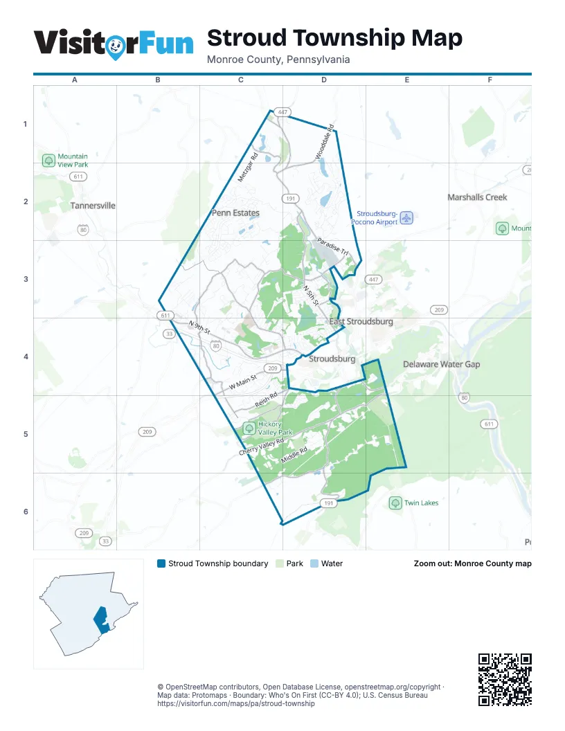
Street index of Stroud Township
Each street on the sheet and the grid squares it crosses.
- Z. H. Confair Memorial HighwayB4, C4, D4
- North 9th StreetB4, C4, D4
- Foxtown Hill RoadD4, E4
- Paradise TrailC1, D1, C2, D2, D3
- Bangor Mountain RoadD4, D5, D6
- North 5th StreetD2, D3, D4
- Shafers Schoolhouse RoadB4, C4, C5
- West Main StreetC4
- Creek RoadC1
- Valley View DriveD6
- US Highway 209 BusinessC4
- Cherry Valley RoadE4, C5, D5, E5
- Chipperfield DriveC3, D3, C4, D4
- Wigwam Park RoadB3, C3, B4, C4
- Cranberry RoadB3, C3
- Glenbrook RoadD4, C5, D5
- Wooddale RoadD1, D2
- Poplar Valley Road WestD5, C6, D6
- Reish RoadC4, D4, C5
- Hickory Valley RoadC5
- Cherry Lane RoadC1, C2
- Mill Creek RoadD3
- Stokes Mill RoadD3
- Phillips StreetD4
- Military RoadC4
- Dreher AvenueD4
- King StreetD3
- Hallet RoadC2, D2
- Penn Estates DriveC2, C3
- Middle RoadC5, D5
- Poplar Valley Road EastD5, E5
- Somerset DriveC2, C3
- Pocahontas RoadD1, D2
- Clearview AvenueC3, D3
- Hyland DriveC2, C3
- Beacon Hill RoadC2, D2, C3
- Brushy Mountain RoadD2, D3
- Ramblebush RoadB3
- Wallace StreetD3, D4
- Totts Gap Hill RoadE5
- Lakeside DriveC2, C3
- Kensington DriveC2
- Mazzetti RoadC3, D3, C4, D4
- Metzgar RoadC1, C2
- Blue Mountain CrossingD2
- Hilltop CircleD2
- Greenbriar DriveC2
- Mountaineer DriveC4
- Daffodil DriveD2
- Stroudsmoor RoadD5
- Edgemont RoadD4
- Tanite RoadC4
- Wedgewood Lake DriveC3, D3, C4
- Reunion RidgeD1, D2
- Stonehenge DriveC2, C3
- Arlington AvenueC4, D4
- Bridle RoadC4, C5
- Beech StreetC4
- Frantz RoadB3, B4
- Overlook DriveC2
- Windsor DriveB3, B4
- Olde Mill RunC3, C4
- Conwell StreetD3, D4
- Sandlewood DriveC2
- Stroud Mall RoadC4
- Saint Lukes LaneB4
- Parker LaneC3
- Timberlake RoadD5
- Alpine BoulevardD2
- Rockdale LaneC4
- Arbor WayB3, C3, C4
- White Oaks Manor DriveC3
- Norton RoadD5
- Crowe RoadD3
- Kirkwood RoadC4
- Avenue CD4
- Horizon DriveD4
- Bernadine DriveC4
- Laural StreetD3
- Autumn LaneC3
- Escoll DriveD2
- Woodland DriveC2
- High Terrace RoadB4, C4
- Brentwood DriveC2, C3
- Skinner Hill RoadC4
- Godfrey Ridge DriveD4, E4
- Branch Brook DriveC2
- Mountain View DriveC4
- Jacob Ott RoadC2
- Christopher StreetD3
- Eastshore DriveD2
- Cornerstone WayD2
- Spicebush DriveC2
- Woodside DriveC3
- Godfreys GateD4
- Arnie WayC4
- Sky Pine WayC3
- Deborah DriveC2
- Pickerel PointD1, D2
- Hickory Lane WestC5
- Thornley RoadC3
- Forest DriveD4
- Blue Mountain Lake DriveD2
- Chariton DriveD1, D2
- Learn LaneD2, D3
- Clark RoadC1
- Farmer Bush RoadC3
- Pasquin DriveC2
- Fieldstone LaneB3, C3
- Summerton CircleC2, C3
- Terrace DriveC3, C4
- Brookfield LaneC2
- Cherry Canyon DriveE5
- Wildflower CircleC3, C4
- Horseshoe DriveD2
- Pinebrook RoadD2
- Powerhouse LaneD3, D4
- Cardinal DriveC3
- Melmar DriveD5
- Crestview DriveC3, C4
- Mount Zion AvenueC3
- Candlewood DriveC2
- Larsens LaneD5
- Eagles Rest LaneD5, E5
- Estate DriveC3
- Irish LaneC4
- Tara View DriveC3
- Woodacres DriveC2
- Coursen CourtD5
- Spring Brook RoadC1, D1
- Keystone DriveC4
- Shelbrooke DriveC4, C5
- Murphy RunD4
- Lake DriveC2
- Valley View Drive NorthB4, C4
- Whitestone CornerC4
- Water Tower CircleD2
- Lindbergh AvenueD4
- Quentin RoadD3
- Glenwood DriveC2
- Lessig LaneD5
- Cranberry Heights DriveC3
- Gaunt RoadC4
- Crestwood DriveC2
- Westbury DriveD3
- Wagner WayC6
- Old Coach RoadC5
- Eagles CourtC3
- Sutton DriveD4
- Fox Run RoadD5
- Pocono Commons DriveC4
- Phyllis CourtC3, C4
- Queen StreetD4
- Ridge Farm RoadC3
- Raccoon WayC6
- Ehler StreetD4
- Avenue BD4
- Snapdragon PointD2
- Clause DriveC4, D4
- Willow Pond DriveC3
- Ryan DriveB3
- Fairview AvenueC4, D4
- Runnymede DriveC2
- Dryden RoadC4, D4
- Avenue AD4
- Bridge StreetC4
- Arrowhead RoadD3
- Belaire DriveC3
- Acker RoadC3, C4
- Pinewood LaneB3
- Flagler TrailC4
- Woodruff LaneB3
- Hedgerow LaneB3
- Duck Hollow CircleD4, D5
- Progress StreetD3
- Old Orchard RoadC4, C5
- Pine Grove DriveC2, C3
- White StreetD4
- Spruce StreetD3
- Columbus AvenueD4
- Hickory CircleC5
- Shaghbark LaneB3
- West Hills DriveC4
- Witness Tree CircleD2
- Croasdale RoadE5
- Larkspur DriveB3
- Ramegwa Ridge RoadC4
- Grey Fox DriveD5
- Greenwood RoadD4
- Commerce BoulevardB4
- Althea LaneD3
- Avenue ED3, D4
- Village DriveD4
- Manitou LaneB3, C3
- Ridgeview RoadC4
- Flagler StreetC4
- White Blossom LaneD2
- Julian TerraceC2
- Francis LaneC4
- Riverbend TerraceC2
- Lloyds LaneC4
- Broadacre DriveC5
- Clicko LaneC2, C3
- Concord DriveC5
- Howell TerraceC4
- Fernwood DriveC2
- Mahlon DriveC5, D5
- Pin Oak TerraceD2
- Gertrude StreetB3
- Hiro LaneD3
- Wooddale CircleD2
- Aspen RoadC5
- Fawn RoadD3
- Mervine RoadD5
- White Birch StreetD3
- Cave RoadC5
- Anna Mae RoadC1
- Linmar DriveB4, C4
- Bel Tor DriveD5
- Sugar Cone LaneC1, D1
- Cottontail LaneD3
- Sundew DriveC2
- Campground RoadC2, D2
- Mockingbird Hill RoadC3
- Oakwood AvenueD3
- Lansdale DriveC2
- Sunrise DriveD4
- Creekwood DriveD5
- Astilebe WayD2
- Fairground CircleC4
- Brislin RoadB4
- Blue Beech DriveC2
- Hollow DriveD2
- Youngwood DriveD3
- Fremont AvenueD3
- Mountain Run Farm RoadD5
- Roosevelt StreetD3
- Fox Hollow RoadC3
- Avenue FD3, D4
- Longdon CourtD2
- Sandee LaneC4
- Appenzeller AvenueD3, D4
- Bamboo LaneC3
- Burntwood DriveC2
- McMichael DriveD4, D5
- Oxford CircleD4
- Breezy View LaneC4
- Constitutional DriveC4
- Southshore MeadowsD2
- Rosemond AvenueD4
- Charles WayC4
- Church StreetD4
- Heritage DriveC4
- Paula DriveD5
- Townsend CircleB3
- Canterbury MainC3
- Leafy Greene StreetC4
- Shady Tree DriveC2
- Burgoon RoadD3
- Boxwood LaneB3, C3
- Bonnie DriveD3
- School View LaneD3
- Twin Leaf LaneD2
- Ledgewood DriveC2
- Radio DriveC4
- Timber Ridge RoadD2
- Glenview AvenueD4, D5
- Roaring Brook RoadC1, D1
- Kennedy DriveD6
- Mountainside DriveE5
- Firehouse LaneC4
- Hawthorne TerraceD3
- Linwood DriveC3, C4
- Metal Run RoadD5
- Ramapo LaneD3
- Deerfield LaneB4, C4
- Skyline DriveD3
- Clover LaneC2
- Truss RoadC4
- Heathrow LaneB3
- Mohawk TrailD3
- Northgate RoadD4
- Edinger DriveC4
- Our WayC3
- Marsh DriveD2
- Sweet Fern RoadC4, D4
- Rural CourtB3
- Delia TerraceC3
- Springdale LaneC4
- Wiley AvenueD3
- Reston DriveC2
- Well House RoadD5
- Jocarr RoadD4
- Lexington DriveC4
- Lourdes AvenueD3
- Tawny Fox TrailC2
- Fox CircleC5
- Fable Flats RoadD4
- Summit TerraceC2
- Windsor CourtC2
Places on the map
- Analomink Lake
- Arlington Heights
- Arlington Lake
- Back Nine Trail
- Bartonsville Plaza
- Big Pines Park
- Blue Mountain Lake
- Broadhead Creek Trail
- Brodhead Creek Park
- Clarke Falls
- Cranberry Run Campground
- Creekview Park
- Crossroads Mall
- ForEvergreen Nature Preserve
- Fox Hill
- Foxtown Hill
- Glen Brook Golf Club
- Glen Run Nature Preserve
- Hickory Valley Park
- Highland Lake
- Katz Park
- Kovarick Park Lands
- Lowe's
- Lower Twin Lake
- McMichael Creek Greenway
- Penn Estates
- Penn Square Office Park
- Pinebrook Park
- Pocahontas Lake
- Pocono Commons
- Pocono Vacation Park
- Shoppes at Stroud
- Stokes Mill Park
- Stroud Mall
- Stroud Township Yard Waste Compost Facility
- Target
- The Home Depot
- The Knob
- Wigwam Lake
- Yetter Park
Next to Stroud Township
- Delaware Water Gap
- East Stroudsburg
- Marshalls Creek
- Stroudsburg
- Tannersville
© OpenStreetMap contributors, Open Database License, openstreetmap.org/copyright · Map data: Protomaps · Boundary: Who's On First (CC-BY 4.0); U.S. Census Bureau















