

Rhode Island map
Narragansett map
About 14,407 people live here (Census Bureau, 2024 estimate). The sheet's index lists 300 streets; Ocean Road, Boston Neck Road and Point Judith Road cross the most grid squares. Things to do inside the boundary: Block Island Ferry.
Open the map (PDF, US Letter)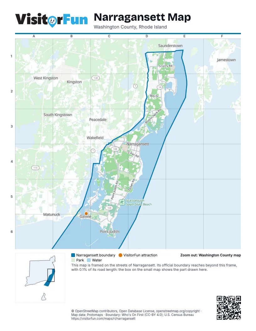
Street index of Narragansett
Each street on the sheet and the grid squares it crosses.
- Ocean RoadD4, C5, D5, C6
- Boston Neck RoadD1, D2, D3, D4
- Point Judith RoadC3, C4, C5, C6
- Galilee Escape RoadB5, C5, C6
- Kingstown RoadC3, D3, D4
- Sand Hill Cove RoadB6, C6
- Post Road FreewayC3, C4
- Great Island RoadB5, B6
- Bridgetown RoadD1
- Narragansett AvenueD3
- Galilee Connector RoadB5, B6
- Commodore Perry HighwayC4
- Tower Hill RoadC3
- Service RoadC4
- Old Boston Neck RoadD1, E1, D3
- South Pier RoadC4, D4
- Succotash RoadB5, B6
- Burnside AvenueC5
- Woodruff AvenueC4
- Middlebridge RoadD3
- KnowleswayC5
- Mumford RoadC3
- Colonel John Gardner RoadE2
- Bonnet Point RoadD2, E2
- Foddering Farm RoadC4
- Windermere RoadC4, D4
- South Ferry RoadD1, E1
- Bonnet Shores RoadD2, E2
- Kinney AvenueC4, D4
- Clarke RoadC5, D5
- East Shore RoadB5, C5
- Gibson AvenueD4
- Caswell StreetD3, D4
- Rodman StreetD4
- Marine DriveC5
- Boon StreetD4
- Conch RoadB5, C5
- Old Point Judith RoadC4
- Lakewood DriveC3, C4
- Harbour Island RoadC4
- Fifth AvenueD4
- Beach StreetD4
- Memorial SquareD4
- Dolphin RoadC5
- Harbor RoadC5
- Indian TrailD1
- Westmoreland StreetC4, D4
- Indian Rock Farm RoadC5
- Cliff DriveD2, D3, E3
- Dean Knauss DriveD1, E1
- Riverdell DriveD1
- West Bay DriveD2
- Treasure RoadE2
- Camden RoadE2
- Saltaire AvenueC6
- Mettatuxet RoadD2
- Cormorant RoadD3
- Old Pine RoadD2
- Wandsworth StreetC4
- Sakonnet BoulevardC5
- Cedar Island RoadC4
- Peaked Rock RoadD3
- Winterberry RoadD1
- Palm Beach AvenueC5
- Conanicus RoadD2
- Kenyon Farm RoadC5
- Central StreetD4
- Daytona AvenueC4, C5
- Spice Bush TrailD2
- Inkberry TrailD2
- Wayland TrailD2
- Tupelo TrailD2
- Sunset BoulevardC5
- Avice StreetC3, C4
- Pettaquamscutt Lake RoadD1
- Polo Club RoadC4
- Circuit DriveD2
- Sunnybrook Farm RoadC4
- Pier RoadE1
- Secluded DriveD2, D3
- Algonquin RoadD2
- Allagash TrailD2, E2
- Houston AvenueC6
- Chestnut AvenueC6
- Angell RoadC5
- South Bay DriveD2
- Edgewater RoadD1
- Crosswynds DriveD1, E1
- Knowlesway ExtensionC5
- Calef AvenueC6
- Beach Plum RoadC4
- Whale Rock RoadD3
- Wampum RoadD2
- Strathmore StreetD3
- Lake RoadD2, E2
- Robinson StreetD3, D4
- Congdon StreetD4
- Wood Hill RoadC4
- Ninigret RoadD2
- Greenbrier RoadC5
- Montauk RoadD2
- Starr DriveD3
- Inez StreetC3, C4
- Bayberry RoadE2
- Saybrook AvenueD2
- Birchwood DriveD1
- Hollywood AvenueC5
- Rye Point RoadC5
- Sarasota AvenueC5
- Sachem RoadD2
- King Philip RoadE2
- Bristol RoadC5
- Stanton AvenueC6
- South River DriveD2
- Woodward StreetD4
- Baltimore AvenueC5, D5
- Sweet Meadows CourtC3, C4
- Durkin DriveC5
- Leonard Bodwell RoadE2
- What Cheer RoadE2
- Leeann DriveD2
- Onondega RoadE2
- Woodsia RoadD1
- White Swan DriveC6
- Jamestown BoulevardC5
- South Cliff DriveD2, D3
- Earles CourtD4
- Lambert StreetC3, C4
- Highland AvenueC3
- Rockland StreetD4
- Longview DriveC5
- Wanda StreetD3
- Crestwood DriveD1
- Wood Sorrel TrailD1
- Meadow Sweet TrailD1
- Flintstone RoadC4
- Wildwood RoadD1
- Basin RoadB5
- Twin Leaf TrailD1
- Pepper Bush TrailD1
- Riverside DriveC3
- Franks Neck RoadC5
- Pettaquamscutt Cove TrailD3
- Webster AvenueE2
- Bonnet View DriveD2
- Tarzwell DriveE1
- Oak Hill RoadC4
- Desano DriveC5
- Carver LaneC5
- Conanicut RoadD2
- Fairway DriveE2
- Brush Hill RoadC4
- Lakeworth AvenueC5
- Meadowrue TrailD1
- Bedford CircleD3
- Maplehurst DriveC4
- Bow RunD1
- Green Kinyon DriftwayC5
- Schooner Cove LaneC5, C6
- Wheatfield Cove RoadC4
- Juniper TrailD2
- Hazard AvenueD4
- Wyndcliff DriveD1, E1
- Garden Court DriveD4
- State StreetB5
- Southwest RoadC6
- Sassafras TrailD2
- Willett RoadE1
- Iroquois RoadD2
- Horizon DriveE1
- Pocono RoadC6
- Shore RoadC6
- Starfish DriveB5, C5
- Anawan DriveD2, E2
- Clubhouse DriveC4, D4
- Anna Olivo CourtD4
- Anchorage RoadE2
- Fernleaf TrailD2
- Middle RoadC5
- Homeland AvenueC3
- Lakeside DriveD1
- Sumac TrailD2
- Isabelle DriveD1, D2
- Seaport DriveC4
- Ray Trainor DriveD1
- Oak AvenueC6
- Wolfe RoadE2
- Thule Cove RoadD3
- Checkerberry RoadD2
- Gardenia LaneD2
- Summit RoadC5
- Staff Sergeant Camara StreetD3
- Lakeview DriveD1, D2
- Wood AvenueD3
- Admirals WayC6
- Old Ocean RoadC6
- Courtland DriveD1, D2
- Overlook RoadD1
- Pontiac RoadD1
- Sergeant Caldwell RoadD3
- Saint James RoadC5
- North River DriveD2
- Canonchet WayD3
- Coffey AvenueC5
- Major Arnold RoadC5
- Peaked Rock LaneD3
- Othmar StreetD3
- Sea Crest DriveC5
- Frances AvenueC5
- Richard Smith RoadE2
- Orlando DriveC5
- Elizabeth RoadC5
- Mountview RoadD2
- Kendall CourtD4
- Goose Island RoadC5
- Walts WayC4
- Hills ParkwayC5
- Sewell RoadC5
- Azalea RoadD2
- Wake Robin TrailD1
- Tern RoadC4
- Exeter BoulevardC5
- Pier Market PlaceD3, D4
- Glocester RoadC5
- Davisville LaneC5
- Fir DriveC6
- Maple AvenueC6
- Dunes RoadE2
- Foster LaneC5
- Ottawa TrailD2
- Maywood RoadE2
- Pennsylvania AvenueC5, D5
- Lincoln WayC5
- Walcott AvenueC5
- Crest AvenueD2
- Withington RoadE2
- Gaspee RoadC5
- Hope LaneC5
- Marian AvenueD2
- Osceola AvenueD2
- Pilgrim AvenueC6
- Watson AvenueD4
- Woodridge RoadD2
- Shagbark RoadD2
- Lauderdale DriveC5
- Ridge DriveD3
- Teal Pond RoadC5
- Wildfield Farm RoadD4
- Starr Drive WestD3
- Celestial DriveD1
- Cypress AvenueC6
- Old Town TrailD2
- Abalone RoadC5
- Green Meadow DriveC6
- Melville LaneC5
- Glendale RoadC5
- Birch StreetC6
- Willow AvenueC6
- Burbank AvenueE2
- Joy LaneD2
- Clara LaneD2
- Oxeye TrailD1
- Muratore LaneD2
- Sea Ridge DriveE1
- Betony RoadD1
- John Brown LaneD1
- Spruce AvenueC6
- Newport LaneC5
- Pleasant AvenueC3
- Johnson AvenueD2
- Spindrift RoadC5
- Bellevue CourtC5
- Kingston LaneC5
- Mathewson StreetD4
- Aroostook TrailD2
- Prospect AvenueC3, C4
- Follett RoadC6
- Linden RoadD2
- North Hillview DriveD2
- Thornapple RoadD2
- Congress RoadD3
- Yellow Birch RoadD2
- Ocean View DriveC5
- Ashton LaneC5
- Salem TrailD2
- Julia AvenueC5
- Baker RoadD3
- Newton AvenueD4
- Bass Rock RoadD5
- Greene LaneC5
- Manning DriveC5
- North Cliff DriveD2
- Charlestown BoulevardC5
- Algonquin TrailD2
- Fox DriveC5
- Nepaug RoadD2
- South Hillview DriveD2
- Mohawk TrailD2
- President DriveD3
- Sunset Shore DriveC5
Things to do on the Narragansett map
Places on the map
- Albro Island
- Ann Gall Durbin Aquarium
- Aqua Blue Hotel
- Aunt Carrie's
- Baron's Homemade Ice Cream
- Bass Rock Road Waterfront
- Beach Island
- Big White Hill
- Block Island Ferry
- Bluff Hill
- Bluff Hill Cove Oyster Farm (Cataldo)
- Bonnet Shores Beach
- Bonnet Shores Beach Club
- Camp Varnum
- Captain Roger W Wheeler State Beach
- Cedar Island
- Domenic Christofaro Park
- Domenic Cristofaro Memorial Park
- Dunes Club Beach
- East Matunuck State Beach
- Fishermen's Memorial State Park Campground
- Fort Greene
- Franford
- Galilee Bird Sanctuary
- High Point
- Lake Canonchet
- Little Neck Pond
- Long Cove Campground
- Narragansett Elementary School
- Narragansett Pier
- Narragansett Public Schools
- Narragansett Town Beach
- Pell Library National Sea Grant Depository Library
- Pell Marine Science Library
- Point Judith Country Club
- Salt Pond Shopping Center
- Scarborough South State Beach
- Sprague Pond
- Strawberry Hill
- Wesquage Pond
Next to Narragansett
- Jamestown
- Kingston
- Matunuck
- Peacedale
- Saunderstown
- South Kingstown map
- Wakefield
- West Kingston
© OpenStreetMap contributors, Open Database License, openstreetmap.org/copyright · Map data: Protomaps · Boundary: Who's On First (CC-BY 4.0); U.S. Census Bureau















