

Tennessee map
Sumner County map
About 211,721 people live here (Census Bureau, 2024 estimate). The sheet's index lists 53 streets; Highway 109 North, Long Hollow Pike and East Main Street cross the most grid squares. Also on it: Anchor High Marina, Anderson Park and Bledsoe Creek.
Open the map (PDF, US Letter)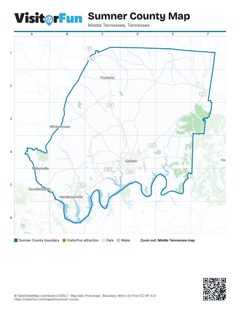
Street index of Sumner County
Each street on the sheet and the grid squares it crosses.
- East Main StreetC1, D4, B5, C5
- Highway 259C1, D1, D2
- Nashville RoadC1
- North Broadway StreetC1, C2
- Vaughn ParkwayC1
- West Main StreetC1, D4, B5
- Fairfield RoadE1, F1, D2, E2
- Andrew Jackson HighwayF1
- New Gallatin RoadF1
- Old Highway 31 East 5F1, F2
- Highway 52 WestB2, C2
- State Route 41B2, B3, A4, B4
- Highway 109 NorthC2, C3, D3, C4, D4, D5
- Highway 52 EastC2, D2, E2
- Portland RoadC2, B3, C3
- Portland White House RoadC2
- South Broadway StreetC2
- Dobbins PikeD2, D3, D4
- New Highway 52 EastE2, F2
- Old Highway 31 EastF2
- Raymond Hirsch ParkwayB3
- Tyree Springs Road SouthB3, B4
- State Route 25C3, C4, D4
- Bethel RoadA4
- Denson LaneA4
- Louisville HighwayA4, A5
- Old Bethel RoadA4
- Long Hollow PikeB4, C4, D4, A5, B5
- New Hope RoadB4, B5
- Tyree Springs RoadB4
- Greenlea BoulevardC4, C5
- Vietnam Veterans BoulevardC4, B5, C5
- Airport RoadD4, D5
- Albert Gallatin AvenueD4
- East BroadwayD4
- East Broadway StreetD4
- Hartsville PikeD4, E4, F4
- Nashville PikeD4, C5
- North Water AvenueD4
- Red River RoadD4
- South Water AvenueD4, D5
- West Albert Gallatin AvenueD4
- West BroadwayD4
- West Eastland StreetD4
- Blue StarA5
- Dickerson PikeA5
- Springfield HighwayA5
- Gallatin PikeB5
- Gallatin RoadB5, C5
- Indian Lake BoulevardB5
- New Shackle Island RoadB5
- Saundersville RoadB5, C5
- Martha Gattlin BridgeD5
Places on the map
- Anchor High Marina
- Anderson Park
- Bledsoe Creek
- Bledsoe Crossing
- Bridle Creek
- Business Park Circle
- Cambria
- Commercial Area
- Cope's Crossing
- Country HIlls
- Creekview Estates
- Crutcher Lake
- CWC Logistics
- Dorris Farm at Willow Springs
- Drakes Creek Park
- Fairvue
- Foxland
- Gallatin
- Gallatin Data Center
- Gallatin High School
- Gallatin Marina
- Gallatin Power Plant
- Gallatin Steam Plant Intake
- Gallating Steam Plant Output
- Goodlettsville
- Grandview Circle
- Hendersonville
- Hendersonville City Limits
- Hoeganaes
- Homestead Place
- Island Brook
- ITW CIP Tennessee
- Kirby Building Systems
- L A Green Lake
- Liberty Creek High School
- Littlestone Apartments
- Lock 4 Main Access (3)
- Long Hollow Golf Course
- Memorial Park
- Millersville
Next to Sumner County
- Goodlettsville
© OpenStreetMap contributors (ODbL) · Map data: Protomaps · Boundary: Who's On First (CC-BY 4.0)