

Texas map
Fredericksburg map
About 11,766 people live here (Census Bureau, 2024 estimate). The sheet's index lists 300 streets; Friendship Lane, South State Highway 16 and North Llano Street cross the most grid squares. Things to do inside the boundary: National Museum of the Pacific War.
Open the map (PDF, US Letter)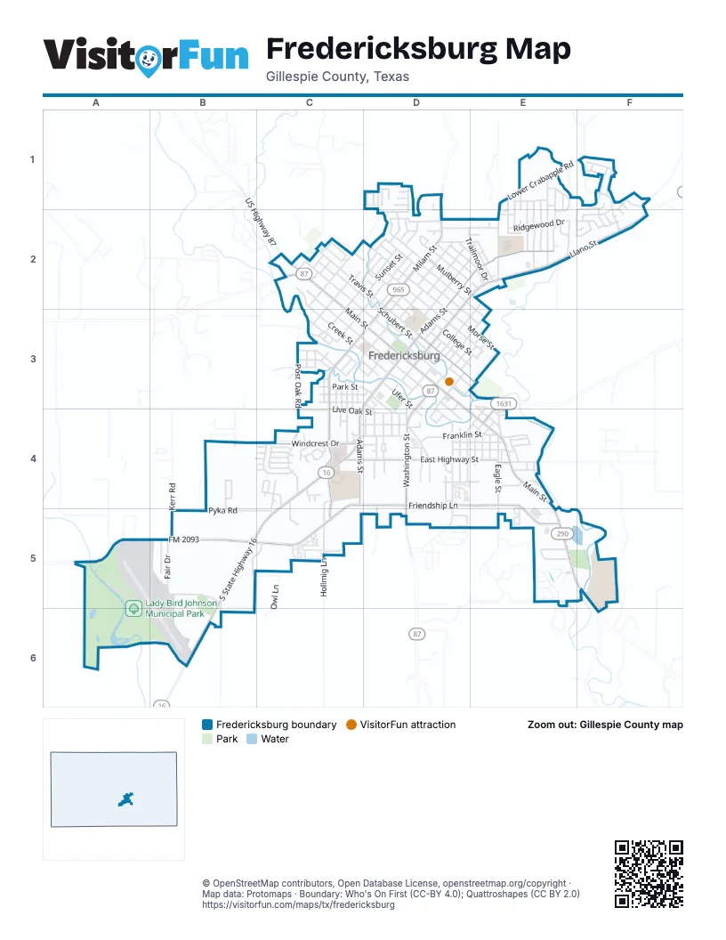
Street index of Fredericksburg
Each street on the sheet and the grid squares it crosses.
- South State Highway 16C4, B5, C5, B6
- North Llano StreetD2, E2, F2, D3
- East Main StreetD3, D4, E4, E5
- South Adams StreetC3, D3, C4
- West Main StreetC2, C3, D3
- South Washington StreetD3, D4
- North US Highway 87C2
- East US Highway 290E5, F5
- West US Highway 290C2
- South US Highway 87D4
- Friendship LaneC4, D4, E4, B5, C5, E5
- North Milam StreetD1, D2, D3
- FM 2093A5, B5
- North Olive StreetE3, E4
- Ranch to Market Road 965D1
- South Milam StreetC3, D3, C4, C5
- North Adams StreetD2, E2, D3
- East Highway StreetC4, D4, E4
- West Windcrest DriveB4, C4
- East Travis StreetD3, E3
- West Mulberry StreetD2
- East Mulberry StreetD2, E2
- Lady Bird DriveA5, A6, B6
- West Travis StreetC2, D2, D3
- West Austin StreetC2, D3
- West Lower Crabapple RoadE1, F1, E2
- West Creek StreetC2, C3, D3
- North Orange StreetD2, D3
- West Schubert StreetC2, D2, D3
- North Cherry StreetD1, C2
- West San Antonio StreetC2, C3, D3
- North Crockett StreetD2, E2, D3
- Fair DriveB5
- West Morse StreetD2
- East Austin StreetD3, E3, E4
- Hollmig LaneC5
- Ridgewood DriveE2
- South Eagle StreetE4, E5
- West Burbank StreetD2
- West Hackberry StreetD2
- East Schubert StreetD3, E3, E4
- Frederick RoadE1, E2
- East San Antonio StreetD3, D4, E4
- North Edison StreetD2, C3, D3
- Post Oak RoadC3, C4
- South Creek StreetD4
- North Washington StreetD3, E3
- West College StreetD2, D3
- Ellebracht DriveF1, F2
- Franklin StreetD4, E4
- North Lincoln StreetD3
- West Centre StreetD2, D3
- Airport RoadA5, B5
- South Lincoln StreetD3, D4
- East Morse StreetD2, D3, E3
- Pyka RoadB5, C5
- South Columbus StreetD4, E4
- North Elk StreetD3, E3
- West Live Oak StreetC4
- Tanglewood DriveE1, E2
- Broadmoor DriveD2, E2
- East Ufer StreetD3, D4
- Industrial LoopE5
- North Bowie StreetC2, D2
- East Walnut StreetC4, D4
- Fulton StreetC3
- East College StreetD3, E3
- Owl LaneB5, C5
- Billie DriveC4, C5
- Sunset StreetD2
- East Center StreetD3, E3
- Mariposa DriveE5, F5
- West Peach StreetC3, D3
- Morning Glory DriveD2, E2
- Briarwood CircleE1, E2
- Northern Red Oak LaneC4
- North Elm StreetD2
- West Nimitz StreetD2
- West Park StreetC3, D3
- Golfers LoopA5, A6
- Bluebonnet StreetD4
- Apple StreetD4, E4
- Cross Mountain DriveD2
- East Orchard StreetD3, E3
- Summit CircleC4
- Summit ForestF1
- Bell StreetD4, E4
- Crestwood DriveE1, E2
- Shaw AvenueC3, D3
- South Bowie StreetC2, C3
- West Driftwood DriveE1, E2
- Edgewood DriveE1, E2
- Heritage Hills DriveE5
- Avenue CD2
- East Creek StreetD3, D4
- AmberstoneF1, F2
- HedgestoneF2
- West Walch AvenueC3, D3
- Glenmoor DriveD2, E2
- Hale StreetC4, D4
- South Orange StreetC3, D3
- Henrietta StreetD4
- East Live Oak StreetC4, D4
- Stone MeadowF1
- Darlington DriveC4
- North Pecan StreetD2
- South Edison StreetC3
- West Trailmoor DriveD2, E2
- Longhorn StreetD4
- Sunrise StreetD4, E4
- Kneese RoadF1
- North Acorn StreetC2
- North Pine StreetD3, E3
- Whitney StreetC3
- Campers LoopA6, B6
- South Crockett StreetD3
- East Burbank StreetD2, E2, E3
- East Hackberry StreetD2, D3, E3
- Seamoor DriveD2, E2
- Business CourtB5
- South Acorn StreetC2, C3
- Reuben StreetC4
- West Ufer StreetC3, D3
- Dudley WayE1, E2
- Quailwood DriveE1
- South Mesquite StreetE4
- South Olive StreetE4
- Riley LaneE1, E2
- North Eagle StreetE3, E4
- Winding WayC4
- Lupine LaneD2
- South Nimitz ParkwayD3
- LightstoneF1
- Windmill Oaks DriveB4, B5
- Green Meadows BoulevardC4
- Goehmann LaneE4
- Green Meadows LaneC4, C5
- Kerr RoadB5
- Vernons LaneC4, C5
- South Elk StreetD3, D4
- Green Oaks LoopC4
- Boos LaneB5, B6
- Eckhardt LaneD4
- Avenue AD2
- Coral StoneF1
- North Kay StreetC2
- Crenwelge DriveE4
- East Park StreetD3, D4
- Stone CanyonF1, F2
- Nimitz CircleD2
- West Grothe StreetE2
- South Llano StreetD3
- Stone OakF2
- Cristol DriveE4
- Dawn LaneD4
- West Orchard StreetD2, D3
- Oak Haven LaneE4
- Avenue BD2
- South Pear StreetE4
- Beverly DriveE4
- Running Buck LaneD1, D2
- Granite AvenueD3, D4
- Chase Oaks PlaceE5
- Buena Vista StreetC3, C4
- Poplar StreetD4
- Saint Ann StreetC3
- Santa Rosa StreetC3, C4
- Silver Maple StreetC3, C4
- East Lower Crabapple RoadE2
- Ettie StreetD4
- Saint Mary's StreetC3, C4
- Kraupahen StreetD4
- StoneledgeF1
- Jessica StreetD2
- West Creekview DriveE5
- South Cherry StreetC2
- Weston LaneC4
- Recreation LoopA5, A6
- South Lee StreetD3, D4
- Smokehouse RoadB4
- Stone HollowF1, F2
- Englemann Oak DriveC4
- Juanita WayD5
- Thiele LaneD4
- North Sycamore StreetD3
- Glenwood DriveE2
- Cora StreetD3
- East Driftwood DriveE2
- Elm StreetD2, D3
- Emory DriveC4
- Shannon DriveB4
- Chinkapin DriveC4
- East Grothe StreetE2
- Holly LaneC2
- Kristofer StreetD2
- Forest TrailE4
- Winfred StreetC3
- Westmoor StreetD2, E2
- East Trailmoor DriveE2
- Skylark DriveE4
- Doe Run HollowD1
- Mueller StreetD4
- Bluebird StreetC3
- Bob White TrailC5
- Mockingbird StreetC3
- Hill StreetD4
- Wildwood DriveE1, E2
- Winston DriveE1, E2
- Plum StreetC3
- Woodcrest StreetC2
- Pavilion LoopA5
- East Windcrest DriveC4, D4
- North Mesquite StreetE4
- Timberwood DriveE2
- North Lee StreetD3, E3
- Tanya StreetD2
- Saint Geralda StreetC3
- East Creekview DriveE5
- Candlelight CircleD2
- Avenue DD2
- Mistletoe StreetD3
- Paintbrush Hollow StreetD1
- Aidan TrailD5
- Alfred StreetC4
- CourtneyD2
- 503 West Ufer StreetC3
- Kimberly LaneD1
- Redbird LaneE5
- SongbirdE5
- East Walch AvenueD3, D4
- Settlement DriveC2, D2
- Sunco AvenueD4
- North Columbus StreetE3, E4
- Clyde RunE2
- Bending Oaks TrailE5
- Lone Oak StreetE4
- Cherrywood DriveE2
- Hoerster RoadD1
- Meadowbrook DriveE5
- Stone ForestF2
- Mustang StreetD4
- Nicole LaneD1
- Persimmon CourtD1
- Vestal DriveE3, E4
- Timber Ridge DriveD2, E2
- Summer Hill DriveE5
- Theodore Specat DriveC2
- Agave CourtD1
- Peachtree LaneE5
- Spotted Fawn TrailD1
- East Hill StreetD4
- West Hill StreetD4
- Smokey Oak DriveB4, C4
- Meadowlark DriveE4
- Prickly Pear CourtD1
- Spruce StreetD3
- Bunny DriveD2
- Bens BluffD5
- StonehavenF1
- Cedar StreetC3
- East Nimitz StreetE2
- Madilynn CourtC4
- Bald Eagle StreetE4
- Gray Oak CourtC4
- Town Creek CourtD2
- Jon StreetE4
- Stone SaddleF1
- Pike LaneE4
- West LaneC4
- Stone PassF1
- StonewoodF1, F2
- Scarlet Oak CourtC4
- Stone GateF2
- Ciarans CrossingD5
- Cottonwood StreetC3
- Mountain View DriveE2
- William StreetC4
- Dusk LaneD4
- Rose StreetC3
- Yellow BarkC4
- IreneC4
- Stone WayF2
- JerryC4
- Jessie LaneB4
- Parkview DriveB4
- Auguste StreetD3, D4
- Waldrip StreetD4
- Winding Way CourtC4
- Taylor CourtC4
- Candlelight CoveD2
- Cross StreetE2
- Redwood CourtE2
- Gibson CourtC4
- Henrietta CourtD4
- Sky LaneC4
- Woodway CourtE2
- Nature TrailE5
- Stone NookF2
- Green Meadows CourtC4
- Atkins CourtC4
Things to do on the Fredericksburg map
Places on the map
- Ace Hardware
- American Legion Hall
- Another Closet Self Storage
- Arrowhead Bank
- August E's
- AutoZone
- B B's Billiards & Bowling
- Backwoods BBQ
- Baron's Creek Shopping Center
- Becker Vineyards Tasting Room
- Bella Sera
- Best Western Plus Fredericksburg
- Bethany Lutheran Church
- Big's
- Bridge Church Fredericksburg
- Broadway Bank
- Buc's Bar & Grill
- Burger King
- Campo Azul Mexican Grill & Bar
- Catfish Haven
- Chevron
- Chick-fil-A
- Comfort Inn & Suites Fredericksburg
- Cross Mountain
- Fort Martin Scott
- Fredericksburg High School
- Fredericksburg Middle School
- Fredericksburg RV Park
- Gillespie County Airport
- Lady Bird Johnson Municipal Golf Course
- Lady Bird Johnson Municipal Park
- Lady Bird Johnson Park Reservoir
- Lady Bird Johnson RV Park
- Marktplatz von Fredericksburg
- Methodist Hospital Hill Country
- Oak Crest Park
- Oakwood RV Resort
- Old Fair Park
- Schneider Hill
- Walmart Supercenter
© OpenStreetMap contributors, Open Database License, openstreetmap.org/copyright · Map data: Protomaps · Boundary: Who's On First (CC-BY 4.0); Quattroshapes (CC BY 2.0)















