

Texas map
Karnes County map
About 15,137 people live here (Census Bureau, 2024 estimate). The sheet's index lists 300 streets; State Highway 80, South US Highway 181 and County Road 277 cross the most grid squares. Things to do inside the boundary: Polish Heritage Center at Panna Maria.
Open the map (PDF, US Letter)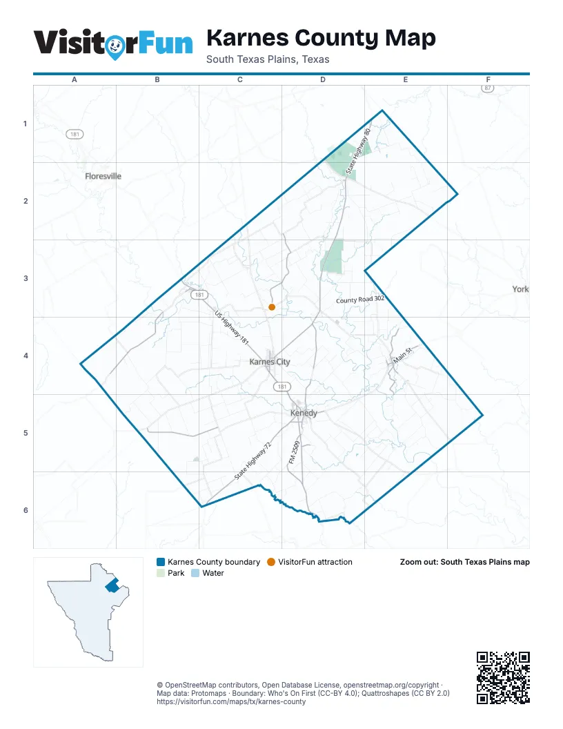
Street index of Karnes County
Each street on the sheet and the grid squares it crosses.
- State Highway 80D1, E1, D2, D3, C4, D4
- South US Highway 181C4, D4, D5, D6
- West State Highway 72C5, D5, C6
- North US Highway 181B3, C3, C4
- East Main StreetE4, D5
- North Sunset Strip DriveD5
- East State Highway 72D5
- Front StreetB3
- West Main StreetE4, D5
- South Sunset Strip DriveD5
- North Badger DriveC4
- South Badger DriveC4
- State Highway 119D1
- Farm-to-Market Road 2724D2, C3, D3
- Farm-to-Market Road 791B3, A4, B4
- Farm-to-Market Road 792D4
- Helena RoadC4, D4, D5
- Escondido StreetD5
- South Helena StreetE4
- East Calvert AvenueC4
- South Panna Maria AvenueC4
- North 5th StreetD5
- Helena StreetE4
- North Panna Maria AvenueC4
- West Calvert AvenueC4
- Franciscan Moczygemba Memorial HighwayC3
- West South Line StreetC4
- North Irvin StreetB3
- West Nelson StreetB3
- South 2nd StreetD5
- PawelekvilleD2
- Badgerette DriveC4
- Maverick StreetB3
- Beaver RoadB3
- Farm-to-Market Road 2102B5, C5
- FM 2509D5, D6
- Farm-to-Market Road 885E4, E5
- East Houston StreetC4, E4, D5
- Houston StreetE4
- State Highway 72 BusinessD5
- Farm-to-Market Road 2773E4
- Polunsky DriveD5
- FM 1145D5
- Lyons StreetE4
- Wilbern StreetE4
- Karnes StreetD5
- Farm-to-Market Road 1020E4
- Yoakum StreetE4
- East Aransas StreetE4
- East Cibolo StreetE4
- Flax Plant RoadD5
- Overby RoadD5
- Borroum StreetD5
- County Road 277D1, E1, D2, E2
- County Road 199B4, B5
- County Road 326D4, E4, D5
- County Road 129E5, D6, E6
- County Road 269D2, E2
- County Road 290D2, E2, E3
- County Road 302D3, E3
- County Road 122E5
- County Road 271E2
- County Road 260C2, D2
- County Road 207B3, B4, C4
- County Road 182C5, C6
- County Road 115E4, E5, F5
- County Road 124D5, E5
- County Road 152C5, D5, C6
- County Road 105E5
- County Road 343C4, D4
- County Road 211B3, C3, C4
- County Road 145D5, D6
- County Road 113F4, F5
- Chicken CreekE5
- County Road 354D3, D4
- County Road 230C3
- County Road 228C3
- County Road 141D6
- County Road 167C5
- County Road 215B4
- County Road 197B4
- County Road 389C3, D3
- County Road 156C6, D6
- County Road 189B5, C5
- County Road 106E4, E5
- County Road 140D6
- County Road 208C4
- County Road 387B3, B4
- County Road 265D2
- County Road 240C3
- County Road 306E2, E3
- County Road 250D3
- County Road 107E4, E5
- County Road 233C2, D2, C3
- County Road 165C5
- County Road 344C4, D4
- County Road 154C6
- County Road 127D5, E5
- County Road 305D3
- County Road 262D2, B3
- County Road 303D3, E3
- County Road 331D4, D5
- County Road 249D3
- County Road 163C5, D5
- County Road 304D2, D3
- County Road 212E1, B3, C3, C4
- County Road 319E3, E4
- County Road 295D3
- County Road 194B4, B5
- County Road 136D5
- County Road 192B5
- County Road 218C4
- County Road 138D5
- County Road 125D5
- County Road 289E1
- County Road 315D4, E4
- County Road 266D2, E2
- County Road 237B3, C3
- County Road 342D4
- County Road 190B5
- County Road 210B4, B5
- County Road 188C5
- Wofford Crossing RoadD4
- County Road 171B5, B6, C6
- County Road 147D5, D6
- County Road 193B5
- County Road 254C3, D3
- County Road 391C3
- County Road 297D3
- County Road 209C4, C5
- County Road 355D4
- County Road 285D1, E1
- County Road 185C4
- County Road 148D5, D6
- County Road 307E2, E3
- County Road 264D2
- County Road 170C5
- Ryan RanchE4
- County Road 184C4, C5
- RockhillE6
- County Road 126D5
- County Road 335E4
- County Road 153C5, C6
- County Road 325E4
- County Road 134E5
- County Road 143C5, D6
- County Road 159C5
- County Road 294D3
- County Road 204B3
- County Road 261D2, D3
- County Road 293D2, D3
- County Road 340D4
- P R 8220D4, D5
- County Road 112E4, F4
- County Road 339E4
- County Road 259D2
- County Road 135D5, E5
- County Road 334D4
- County Road 150D5, C6, D6
- County Road 142D6
- County Road 242C3
- County Road 180C6
- County Road 186C4
- County Road 270E2
- County Road 104E5, F5
- County Road 191B5
- County Road 169C5
- County Road 109E4
- County Road 160C5, D5
- Costilla Petroleum RoadC3, D3
- County Road 345C4, D4
- County Road 263D2
- County Road 119E4
- County Road 166D5
- County Road 216B4, C4
- County Road 360E2
- County Road 229B3, C3
- County Road 323E4
- County Road 256C2, C3
- County Road 214B3
- County Road 251D3, C6
- County Road 158C5, C6
- County Road 175B6, C6
- County Road 332D4
- County Road 312D3
- County Road 275E2, F2
- County Road 174B5, B6
- County Road 252D3, B6
- County Road 330D5
- County Road 388B3
- County Road 386C4
- County Road 313D3
- County Road 311D3
- County Road 227C3
- Y OchoaF5
- County Road 198B4
- County Road 164C5
- County Road 279D2
- County Road 347C4
- County Road 187C4, C5
- County Road 173B5, C5
- Victoria StreetE4, D5
- County Road 176B6, C6
- County Road 196B4, B5
- County Road 268D2, E2
- County Road 178C6
- County Road 224C4
- County Road 181C6
- County Road 206B3
- Goliad StreetE4, D5
- Gilbert MuellerE4
- Private Road 7474C5
- County Road 247C3, D3
- County Road 128D5, E5
- County Road 287D1, E1
- Pr 2290E3
- County Road 253C3, B5
- County Road 336E4
- North Bond StreetC4
- County Road 359E2
- County Road 309D3, E3
- West Houston StreetC4, E4
- County Road 149D6
- County Road 177C6
- North Park AvenueC4
- Romeo KorthE3
- County Road 213B3, C3
- North Apperson StreetC4
- County Road 217C4
- North Davidson StreetC4
- County Road 144C6, D6
- County Road 162C5
- County Road 352C4
- County Road 137D5
- North Johnson StreetC4
- Private Road 2200E2
- Simpson RanchE4
- County Road 2285D2
- County Road 333D4
- Coskey RanchE4
- County Road 350C4
- County Road 221B4, C4
- County Road 179C6
- County Road 258D2
- County Road 329D5
- County Road 301D3
- County Road 328D5
- Pr 2300 RoadD3, E3
- County Road 363D5
- Jay Way RoadE2
- County Road 356D4
- South 5th StreetD5
- County Road 314D3
- County Road 255C3
- County Road 337E4
- County Road 139D5
- County Road 318E4
- East Main AvenueC4
- County Road 300D3, D4
- South Browne StreetC4
- County Road 201B4
- County Road 248D3
- Saint Mary's StreetD5
- South Davidson StreetC4
- North Washington AvenueC4
- North Butler StreetC4
- West Live Oak StreetC4, D5
- County Road 183C5
- Pr Road 6250C4
- County Road 108E5
- North Esplanade StreetC4
- East County Road 302D3
- County Road 219C4
- County Road 390C2, C3
- County Road 111E4
- County Road 132E5
- South Apperson StreetC4
- County Road 220C3
- County Road 168C5
- County Road 157C5, C6
- County Road 396D6
- West Riddleville StreetC4
- Dewitt StreetD5
- County Road 238C3
- County Road 202A4, B4
- Pr Road 6280C4
- County Road 349C4
- Pr 8220E5
- PollokC3, C4
- Refugio StreetE4
- County Road 161D5
- South 7th StreetD5
- Private Road 1135E1
- County Road 341D4
- County Road 283D2
- Mugge StreetE4
- County Road 316E3, E4
- County Road 368D5
- County Road 317E3
- County Road 377C3
Things to do on the Karnes County map
Places on the map
- AutoZone
- Badger Field
- Badger Stadium
- Ball Park
- Baseball
- Baseball Fields Of Karnes City
- Basketball
- Card Airfield
- Escondido Creek
- Escondido Creek Parkway
- Falls City
- Falls City Beaver Stadium
- Falls City City Hall
- Falls City Library
- Falls City Schools
- Joe Gulley Park
- John B. Connally Unit
- Karnes City
- Karnes City Cemetery
- Karnes City Schools
- Kenedy
- Kenedy Cemetery
- Kenedy Elementary School
- Kenedy Regional Airport
- Kenedy Secondary School
- Kennedy Cemetery
- Lookout Hill
- Otto Kaiser Memorial Hospital
- Paul Kutz Fields
- Porter Ranch Airport
- Runge
- Runge City Cemetery
- San Christoval Ranch Airport
- Soccer
- Soil Conservation Service Site 1 Reservoir
- Soil Conservation Service Site 3 Reservoir
- Soil Conservation Service Site 9 Reservoir
- The Lodge at Kenedy
- Tordillo Hill
- W B Burris Airport
Next to Karnes County
- Floresville
© OpenStreetMap contributors, Open Database License, openstreetmap.org/copyright · Map data: Protomaps · Boundary: Who's On First (CC-BY 4.0); Quattroshapes (CC BY 2.0)















