

Virginia map
Accomack County map
About 33,411 people live here (Census Bureau, 2024 estimate). The sheet's index lists 300 streets; Lankford Highway, Church Street and Main Street cross the most grid squares. Things to do inside the boundary: Chincoteague National Wildlife Refuge, Eastern Shore of Virginia and NASA Wallops Visitor Center.
Open the map (PDF, US Letter)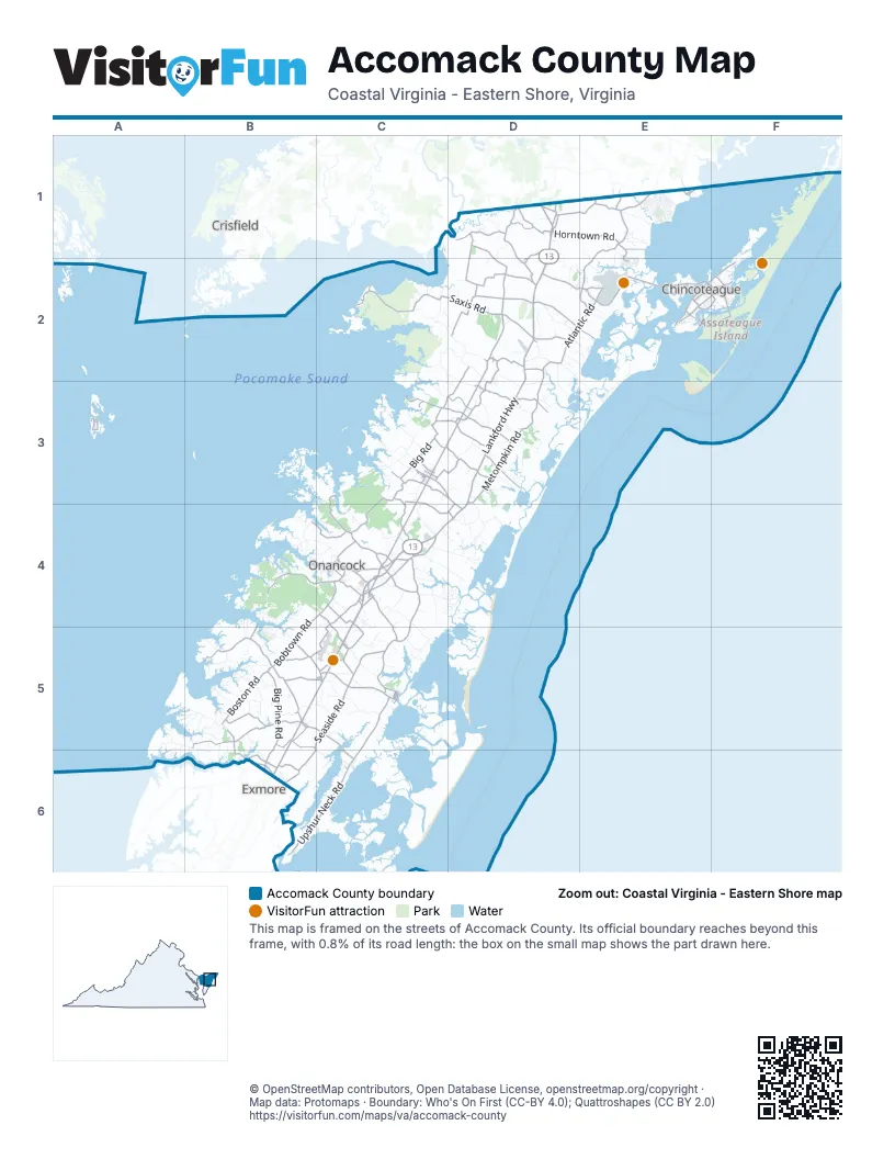
Street index of Accomack County
Each street on the sheet and the grid squares it crosses.
- Lankford HighwayD1, D2, D3, C4, D4, B5, C5, B6
- Chincoteague RoadD2, E2
- Metompkin RoadD2, D3
- Fleming RoadE1, E2
- Main StreetD2, E2, F2, B5, C5, B6
- Atlantic RoadD2, E2
- Greenbush RoadC3, C4
- Bobtown RoadB4, C4, B5
- Front StreetE1, C4, B5
- Boston RoadB5
- Wachapreague RoadC5
- Shields Bridge RoadB5, B6
- Mears Station RoadD2, D3
- Pungoteague RoadB5, C5
- Hopeton RoadC3, D3
- Nelsonia RoadD3
- Parksley RoadC3, D3, D4
- Market StreetC4
- Maddox BoulevardE2, F2
- Coastal BoulevardC4
- Fairgrounds RoadC4
- Hallwood RoadD2
- Bayside DriveD1, E1, D2, D3
- King StreetC4, B6
- Tasley RoadC4
- Bennett StreetC3
- Shore Main DriveD3
- West Main StreetC4
- Cassatt AvenueC3
- Belle Haven RoadB6
- North R North StreetC5
- Cooperative WayC4
- Jefferson AvenueC5
- Overpass DriveC4
- Snow Hill RoadE1
- Saxis RoadC2, D2
- Seaside RoadB5, C5, B6
- Drummondtown RoadC4, C5
- Neal Parker RoadD1, D2
- Upshur Neck RoadB6, C6
- Holland RoadD1, D2
- Bayside RoadC3, C4
- Big Pine RoadB5, B6
- Cashville RoadB4, C4
- Indian Trail RoadB5
- Shell Bridge RoadB5
- Withams RoadD2
- Bethel Church RoadD2, D3
- Nocks Landing RoadD2, E2
- Horntown RoadD1, E1
- Sign Post RoadD1, E1
- Bradfords Neck RoadC5, C6
- Winterville RoadD2, C3, D3
- Big RoadC3
- Guards Shore RoadC3, D3
- Horsey RoadD2
- Hacksneck RoadB5
- Beach RoadF2
- Deep Creek RoadC3, C4
- Pitts Creek RoadD1
- Harborton RoadB4, B5
- Church StreetE1, D2, E2, F2, C3, C4, C5
- Ridge RoadE2, F2, C3
- Gargathy Landing RoadD3
- Bullbeggar RoadD1, D2
- Coal Kiln RoadB5
- Locustville RoadC4, C5
- Redwood RoadC4
- Turkey Run RoadD3
- Plantation RoadB4, C4
- Daugherty RoadC4
- Beacon RoadC4, B5, C5
- Dennis DriveC2, C3, D3
- Church RoadC4
- Wessells Farm RoadD2
- Mason RoadD3
- Quinby Bridge RoadC5, C6
- Merry Branch RoadC4
- Lee Mont RoadC3
- Hollies Church RoadB5, C5
- Savageville RoadC4
- Mappsville RoadD3
- Payne RoadD1, E1, D3
- New Temperanceville RoadD2
- John Cane RoadC3, C4, D4
- Mappsburg RoadB5, C5
- County RoadC3, D3
- Phillips DriveC4, C5
- State Line RoadE1
- Airport DriveC4, C5
- Boggs RoadB5
- Dogwood DriveC4
- Lee StreetC4, C5, B6
- Davis RoadD1, C6
- Green Hill RoadD1, D2
- Justice RoadE1
- Michael Hill RoadB5
- Fisher RoadC3, D3
- Badger LaneC4
- Texaco Town RoadC4
- Race Track RoadC5
- Slocom Farm RoadD1
- Adams RoadC4
- Farlow RoadD1
- Merry Cat LaneB6
- Savagetown RoadB6
- Matthews RoadC2, C3
- Maxwell StreetC3
- East Side RoadE2, F2
- Garland Taylor RoadE1
- Jenkins Bridge RoadD2
- Accomack RoadC4
- Edgar Thomas RoadC4
- Willis StreetC3, C5
- Town RoadC4
- Deep Hole RoadF2
- Guilford RoadC3, D3
- Railroad AvenueD2, B5, C5
- Trails End DriveE1, E2
- Thornton RoadD2
- Liberty StreetD3, C4, C5
- Kelly RoadD1
- Mill Dam RoadE2
- Depot StreetD1
- Willow StreetE2
- West Ridge RoadA3
- Muttonhunk RoadD3
- Hill StreetC4
- East Main StreetC4, C5
- Silverthorne RoadE1
- Drummonds Mill RoadC3, C4
- Chicken City RoadF2
- Adelaide StreetC3
- Hurst Store RoadC3, C4
- Gospel Temple RoadC5
- North StreetC4
- Beebe RoadE2
- Hallie Whoalton Smith DriveF2
- State Route 734C5
- Nelson RoadD1
- Hickman StreetB5
- Main Ridge RoadA3
- Pennsylvania AvenueC4
- Airport RoadC3
- Bunting RoadE2
- Tulls Millpond RoadD1
- Old County RoadD3, D4
- Atlantic AvenueC5
- Courthouse AvenueC4
- Bayfront StreetE1
- Edmunds StreetB5
- Forest StreetC4
- Evans RoadD4
- Brooklyn AvenueC5
- Corbin StreetD2
- Onley RoadC4
- Wayside DriveB5
- State Route 703D2
- Adams CrossingC5
- Center AvenueC5
- Pension StreetE2, F2
- Stockton AvenueE1
- Clark StreetE2, F2
- Warrior DriveC4
- Mitchell RoadD3
- Outten RoadE1
- Factory RoadA3
- Richardson AvenueC5
- 1st StreetC5
- Madigan WayC4
- School LaneA3
- Long Bridge RoadA3
- Greenbackville RoadE1
- Dunns Swamp RoadD1
- Bank StreetC4
- Silva RoadE1
- Onancock WharfC4
- Barnes RoadD1
- Cattail RoadC2, D2, D3
- Savannah RoadC2, D2
- Captains CorridorE1
- Mount Nebo RoadB4
- Baylys Neck RoadC4, D4
- Burtons Shore RoadC4, C5
- Bells Neck RoadB6, C6
- Wildlife DriveF2
- Poplar Cove RoadB4, C4
- Fox Grove RoadD3, D4
- Scarboroughs Neck RoadA5, B5, A6, B6
- Craddock Neck RoadA5, B5
- Custis Neck RoadC4, D4
- Coardtown RoadD1, D2
- Joynes Neck RoadC4, D4
- North Seawall RoadE2, E3
- Whites CrossingD2, D3
- Saint Thomas RoadC3
- Whites Neck RoadD3, D4
- Country Club RoadB5
- Greta RoadD2
- Stone House RoadC4
- Pennyville RoadB5
- Causeway RoadD2, E2, E3
- Miles RoadD1
- Arbuckle Neck RoadD2, D3
- Parsons RoadC3, C4
- Jerusalem RoadD2
- Sawyer DriveC4
- Kegotank RoadD3
- Red Bank LaneB4
- New Branch RoadC4
- Evans Wharf RoadB4
- Mink Farm RoadC3, C4
- Teackle RoadA5, B5
- Red Hills RoadE1
- Anns Cove RoadC3
- Logan RoadC4
- Keller Pond RoadB5, C5
- Marsh Market RoadC2
- Fair Oaks RoadC5
- Cedar View RoadB5
- Johnson RoadD4
- Keller Fair RoadC5
- Broadway RoadB4
- Groton Town RoadD2, D3
- Belinda RoadC2
- Acorn DriveB4, C4
- Back Creek RoadB5
- Chesser RoadD2
- Burton RoadB5
- Dingleys Mill RoadB4, C4
- Bailey Neck DriveB4
- Fletcher RoadD3
- Oak Farms LaneB5
- Flying Dutchman DriveE1
- Rose Cottage RoadC5
- Hyslop LaneB5
- Mary N Smith RoadC4
- Ravenswood DriveC4
- Parks RoadC4, D4
- Messongo RoadC2, D2
- Fairview RoadB5
- Bellevue CircleC5
- State Route 743C5
- Wisharts Point RoadD2, E2
- Southside RoadB4
- Gladding RoadD3
- Kittens Branch RoadC4
- Bay Breeze DriveE2
- Olde Mill PointeE2
- Deerfoot RoadC5
- Blue Crab CircleB6
- Trower RoadC5
- Baker RoadD3
- Gladding Landing RoadC2, C3, D3
- Tarkill RoadB4
- Justisville RoadC3
- Alicato RoadD4
- Drummond RoadB5
- Tunnels Mill RoadD1, D2
- Killmontown RoadB4, C4, B5, C5
- Jolly Roger DriveE1
- Shanghai RoadE1
- Littleton RoadD3
- Occohannock DriveA5, A6
- Hopeland RoadD3
- Pickpenny RoadC5
- Beartown RoadD3
- Ortley LaneA5, A6
- Craddockville RoadB5
- Savage CircleC5
- Piggin RoadC5
- Folley Farm RoadC4
- Muddy Creek RoadC3, D3
- Corbin Hall LaneE1
- Taylor Farm RoadD2, E2
- Berry RoadD3
- Breezy Point RoadB4
- Chandler RoadD3
- Doe Creek RoadC3
- Davis Wharf RoadB5, B6
- A S West RoadB5
- Coventon LaneE1
- Hopkins RoadC3
- Red Hill RoadC5
- Mirina RoadC3
- Buccaneer BoulevardE1
- Nandua RoadB5
- India LaneB4
- Sanns SquareD3
- Leonard LaneD1, F1, F2
- Seaside CircleD3
- Navigator DriveE1
- Martin RoadB4, B5
- Sand StreetD2
- Pine DriveE1, E2, F2, D3
- Evergreen RoadB4, B5
- Sisco Town RoadB5
- Full Measure LaneB5
- Gaskins RoadC4
- Bloxom RoadD3
Things to do on the Accomack County map
Places on the map
- Accomac
- Accomack County Airport
- Assateague Channel
- Atlantic
- Back Creek
- Bayside
- Belle Haven
- Big Marsh
- Black Point Gut
- Bloxom
- Bobtown
- Boston
- Bradford Bay
- Bulls Head
- Butcher Creek
- Byrds Marsh
- Captains Cove
- Cats Bridge
- Chase Crossing
- Cherrytree Hill Bay
- Chincoteague
- Chincoteague Channel
- Chincoteague National Wildlife Refuge
- Craddock Creek
- Curratuck Creek
- Deep Creek
- East Point Marsh
- Gargatha
- Goose Island
- Greenbackville
- Greenbush
- Guard Shore
- Hallwood
- Harborton
- Horntown
- Janeys Creek Marsh
- Keller
- Lee Mont
- Locust Mount
- Makemie Park
Next to Accomack County
- Crisfield
- Exmore
© OpenStreetMap contributors, Open Database License, openstreetmap.org/copyright · Map data: Protomaps · Boundary: Who's On First (CC-BY 4.0); Quattroshapes (CC BY 2.0)















