

Virginia map
Norfolk map
About 231,105 people live here (Census Bureau, 2024 estimate). The sheet's index lists 191 streets; Hampton Roads Beltway, Chesapeake Boulevard and Granby Street cross the most grid squares. Things to do inside the boundary: Chrysler Museum of Art.
Open the map (PDF, US Letter)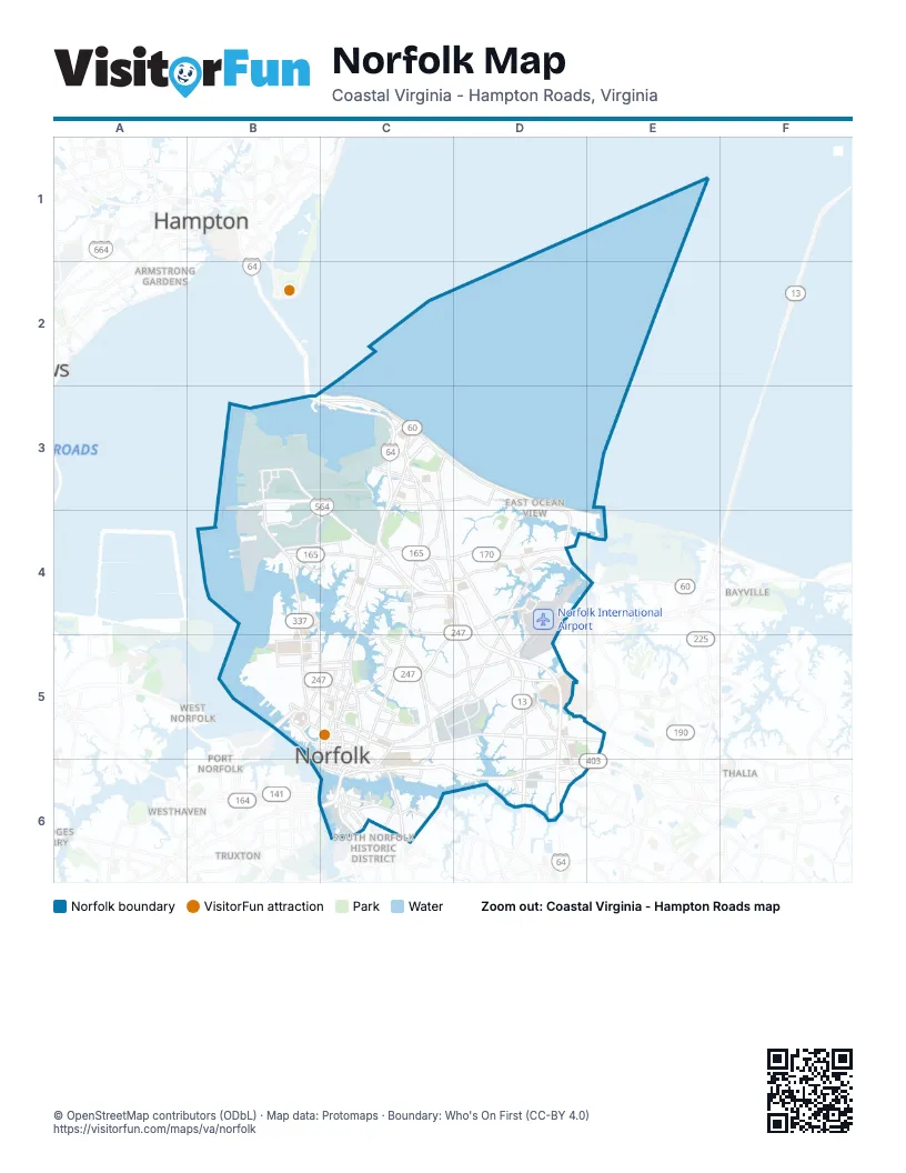
Street index of Norfolk
Each street on the sheet and the grid squares it crosses.
- Admiral Taussig BoulevardB3, C4
- B AvenueB3
- Bainbridge AvenueB3
- Gilbert StreetB3
- Hammond AvenueB3
- Hampton BoulevardB3, B4, B5
- Hampton Roads BeltwayB3, C3, C4, D4, D5, D6
- Hampton Roads Bridge-TunnelB3
- Intermodal ConnectorB3, C3, C4
- Mall DriveB3
- Seabee RoadB3
- Virginia AvenueB3
- 4th View StreetC3
- Chesapeake BoulevardC3, C4, D4, C5, D5
- East Bay AvenueC3
- East Bayview BoulevardC3, D3
- East Chester StreetC3
- East Ocean AvenueC3
- East Ocean View AvenueC3, D3, D4
- First View StreetC3
- Granby StreetC3, C4, C5, C6
- Hammett AvenueC3
- Hampton Roads Bridge–Tunnel Expansion ProjectC3
- Maple AvenueC3
- Mariners WayC3
- Mason Creek RoadC3
- O Connor CrescentC3
- Old Ocean View RoadC3, C4
- Ridgewell AvenueC3
- Rippard AvenueC3
- Tidewater DriveC3, C4, C5, C6
- West Bay AvenueC3
- West Ocean AvenueC3
- West Ocean View AvenueC3
- Capeview AvenueD3
- Colley AvenueB4, B5, C5
- Elementary DriveB4
- Fechteller RoadB4, C4
- Helmick StreetB4
- Ingersol AvenueB4
- Jamestown CrescentB4
- Monrovia StreetB4, C4
- Norfolk Crossing AvenueB4, C4
- North Fairwater DriveB4
- North Shore RoadB4, C4
- Richmond CrescentB4
- Terminal BoulevardB4, C4
- West Little Creek RoadB4, C4
- Central Business Park DriveC4
- Denison AvenueC4
- Diven StreetC4
- East Admiral Taussig BoulevardC4
- East Little Creek RoadC4, D4
- Hedgewood LaneC4
- I 64 Express LanesC4, D4, D5, D6
- Johnstons RoadC4, D4
- Kingsley LaneC4
- Louisiana DriveC4
- Newport AvenueC4
- North Military HighwayC4, D4, D5, D6
- Norview AvenueC4, D4, D5
- Philpotts RoadC4
- Ruthven RoadC4
- Sewells Point RoadC4, D4, D5
- Thole StreetC4
- Virginian DriveC4
- Widgeon RoadC4
- Willow Wood DriveC4, C5
- Airport RoadD4
- Azalea Garden RoadD4, D5
- Bayside RoadD4
- Halprin DriveD4
- Heutte DriveD4
- Robin Hood RoadD4, C5, D5
- Shore DriveD4, E4
- 49th StreetB5
- Azalea CourtB5
- Botetourt StreetB5
- Brambleton AvenueB5
- Claremont AvenueB5
- College PlaceB5, C5
- Colonial AvenueB5, C5
- Midtown TunnelB5
- Midtown Tunnel ExpresswayB5
- Nancy Lieberman PassB5
- Powhatan AvenueB5
- Redgate AvenueB5
- West 21st StreetB5, C5
- West 26th StreetB5, C5
- West 27th StreetB5, C5
- West 38th StreetB5, C5
- West 43rd StreetB5
- West Brambleton AvenueB5, C5
- West Olney RoadB5, C5
- West Princess Anne RoadB5, C5
- Ballentine BoulevardC5, C6
- Boush StreetC5, C6
- Cape Henry AvenueC5, D5
- Church StreetC5
- Cromwell DriveC5
- Cromwell RoadC5
- Duke StreetC5
- East 18th StreetC5
- East 20th StreetC5
- East 21st StreetC5
- East 26th StreetC5
- East 27th StreetC5
- East Brambleton AvenueC5, C6
- East Bute StreetC5
- East Charlotte StreetC5
- East Olney RoadC5
- East Princess Anne RoadC5, D5
- East Virginia Beach BoulevardC5, D5, E5
- Ingleside RoadC5, D5
- Lafayette BoulevardC5
- Leo StreetC5
- Lindenwood AvenueC5
- Llewellyn AvenueC5
- Maltby AvenueC5
- Monticello AvenueC5, C6
- Norway PlaceC5
- Park AvenueC5, C6
- Rugby StreetC5
- Saint Julian AvenueC5
- Saint Pauls BoulevardC5, C6
- Village AvenueC5, D5
- Virginia Beach BoulevardC5, E5
- West 35th StreetC5
- West Bute StreetC5
- West Charlotte StreetC5
- West Freemason StreetC5
- West Tazewell StreetC5
- West Virginia Beach BoulevardC5
- Wood StreetC5
- Almeda AvenueD5
- Glenrock RoadD5
- Kempsville RoadD5, D6
- Kilmer LaneD5
- Lowery RoadD5
- Northampton BoulevardD5
- Poplar Hall DriveD5
- Raby RoadD5
- Round Bay RoadD5
- Sabre RoadD5
- Wesleyan DriveD5
- Newtown RoadE5, D6, E6
- Atlantic StreetC6
- Bainbridge BoulevardC6
- Berkley AvenueC6
- Berkley Brdg Acc RoadC6
- Berkley BridgeC6
- Campostella RoadC6
- Clifton StreetC6
- Downtown TunnelC6
- East Berkley AvenueC6
- East City Hall AvenueC6
- East Indian River RoadC6
- East Liberty StreetC6
- East Main StreetC6
- East Plume StreetC6
- East Water StreetC6
- Halifax StreetC6
- Indian River RoadC6
- Kimball TerraceC6
- Liberty StreetC6
- Market StreetC6
- Marsh StreetC6
- Obendorfer RoadC6
- South Main StreetC6
- State StreetC6
- Union StreetC6
- Virginia Beach-Norfolk ExpresswayC6, D6, E6
- Waterside DriveC6
- West Berkley AvenueC6
- West City Hall AvenueC6
- West Indian River RoadC6
- West Liberty StreetC6
- West Main StreetC6
- West Plume StreetC6
- Wilson RoadC6
- Center DriveD6, E6
- Corporate BoulevardD6
- Curlew DriveD6
- Greenwich RoadD6, E6
- Military Highway Service RoadD6
- Princess Anne RoadD6
- South Military HighwayD6
- South Military Highway Service RoadD6
- South Newtown RoadD6
- Susquehanna DriveD6
- Stoney Point SouthE6
Things to do on the Norfolk map
Places on the map
- 43rd & Elkhorn Avenue Garage
- 49th Street Stadium Garage
- 5 Hole Golf Course
- Africa-Okavango Delta
- Air Cargo
- Asian - Trail of the Tiger
- Azalea Acres Neighborhood Park
- Azalea Middle School
- BAE Systems Norfolk Ship Repair
- Ballentine School
- Barraud Park
- Barry Robinson Center School
- Bay Oaks Park
- Bay View Elementary School
- Ben Moreell Military Housing
- Berkley Community Park
- Blair Middle School
- Booker Taliaferro Washington High School
- Breezy Point Park
- Brickell Library
- Broad Creek Park
- Calvary Cemetery
- Camp Allen Elementary School
- Castle Acres Apartments
- Cedar Grove Cemetery
- Children's Hospital of the King's Daughters
- Childrens Tower
- City Hall Complex
- Colonna Yachts
- Colonna's Shipyard - Main Yard
- Colony Points Apartments
- Community Beach Park
- Concourse B
- Costco
- Crossroads Elementary School
- East Beach Shoppes
- Edgewater
- Elizabeth River Trail
- Elmwood Cemetery
Next to Norfolk
- Armstrong Gardens
- Bayville
- Fordham
- Hampton
- Port Norfolk
- Simonsdale
- South Norfolk Historic District
- Thalia
- Truxton
- West Norfolk
- Westhaven
© OpenStreetMap contributors (ODbL) · Map data: Protomaps · Boundary: Who's On First (CC-BY 4.0)