

Washington map
Anacortes map
About 18,148 people live here (Census Bureau, 2024 estimate). The sheet's index lists 300 streets; State Route 20 Spur, Oakes Avenue and A Avenue cross the most grid squares. Things to do inside the boundary: Outer Island Excursions and Salish Sea School Discovery Center.
Open the map (PDF, US Letter)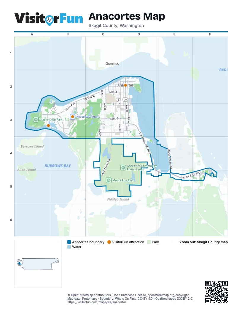
Street index of Anacortes
Each street on the sheet and the grid squares it crosses.
- State Route 20 SpurD3, D4, D5, E5
- State Route 20E5, F5
- Commercial AvenueD2, D3
- Oakes AvenueB2, C2, B3
- 12th StreetC2, D2
- Ferry Terminal RoadB2, B3
- Lane 17B2, B3
- Lane 16B2, B3
- Lane 15B2, B3
- Lane 14B2, B3
- Lane 1B2, B3
- Lane 13B2, B3
- Lane 12B2, B3
- Lane 2B2, B3
- Lane 3B2, B3
- Lane 11B2, B3
- Lane 4B2, B3
- Lane 5B2, B3
- Lane 10B2, B3
- Lane 6B2, B3
- Lane 7B2, B3
- Lane 8B2, B3
- Lane 9B2, B3
- Lane 20 - InternationalB3
- Lane 19 - InternationalB3
- Lane 18 - InternationalB3
- Sharpes CornerE5
- International LaneB2, B3
- R AvenueD2, D3
- Q AvenueD2, D3
- D AvenueC2, C3
- 32nd StreetC3, D3
- 22nd StreetC3, D3
- 37th StreetC3, D3
- A AvenueC2, C3, C4
- 4th StreetC2, D2
- Anacopper Mine RoadB2, B3
- Pennsylvania AvenueB3
- M AvenueC2, C3
- Heart Lake RoadC4, C5
- South Marchs Point RoadF4, E5, F5
- O AvenueD2, D3, D4
- H AvenueC2, C3, C4
- KingswayA3, B3
- Anaco Beach RoadB3
- J AvenueC2, C3
- Marchs Point RoadE4, F4, E5
- 41st StreetC3, D3
- I AvenueC2, C3
- Skyline WayA3, B3
- 6th StreetC2, D2
- 8th StreetC2, D2
- Sunset AvenueA3, B3
- F AvenueC2, C3
- Reservation RoadF5
- Summit Park RoadE5
- Fidalgo AvenueD3
- Thompson RoadE5
- Guemes Ferry loading laneC2
- Christianson RoadE5
- Jasper WayB3
- Marine DriveB3, B4
- Guemes Ferry DockC2
- Sunrisers LaneB3
- March Point RoadE5
- South Texas RoadE4
- Loop RoadA3
- Fidalgo Bay RoadD3, D4
- Erie Mountain DriveC4, C5
- N AvenueD2, C3, D3
- 17th StreetC2, D2
- L AvenueC2, C3
- K AvenueC2, C3
- 11th StreetC2, D2
- 34th StreetC3, D3
- 30th StreetC3, D3
- 10th StreetC2, D2
- 9th StreetC2, D2
- T AvenueD2, D3
- 24th StreetC3, D3
- 28th StreetC3, D3
- 36th StreetC3, D3
- 29th StreetC3, D3
- 7th StreetC2, D2
- 14th StreetC2, D2
- 13th StreetC2, D2
- Glasgow WayB3
- West 2nd StreetB2, C2
- B AvenueC2, C3
- 5th StreetC2, D2
- Doon WayB3
- 38th StreetC3, D3
- 15th StreetC2, D2
- Marine Heights WayB3, B4
- 20th StreetC2, D2
- 16th StreetC2, D2
- 35th StreetC3, D3
- Stevenson RoadE5, F5
- Bryce DriveB3
- Shannon Point RoadA2, A3
- West 3rd StreetB2, C2, B3
- 26th StreetC3, D3
- Highland DriveB3
- South Fidalgo Bay RoadD4, D5, E5
- 23rd StreetC3, D3
- G AvenueC2, C3
- Whistle Lake RoadD3, D4
- V AvenueD2, D3
- 33rd StreetC3, D3
- C AvenueC2, C3
- 31st StreetC3, D3
- Rock Ridge ParkwayB3
- 3rd StreetC2, D2
- Heather DriveB3
- 18th StreetC2, D2
- 25th StreetC3, D3
- Washington BoulevardA3
- West 5th StreetC2, B3
- Cypress DriveB3
- Kansas AvenueB2, B3, C3
- West 4th StreetB2, C2, B3
- E AvenueC2, C3
- Padilla Heights RoadF5
- Yorkshire DriveB3
- West 6th StreetB3, C3
- Parkside DriveA3
- Creekside LaneC3
- 19th StreetC2, D2
- Sands WayA3
- 39th StreetC3, D3
- Longview AvenueD3
- West 12th StreetB3, C3
- 21st StreetC3, D3
- S AvenueD3
- MacBeth DriveB3
- Sugarloaf StreetA3, B3
- Orchard AvenueC3, C4
- Schooner DriveB3
- 27th StreetC3, D3
- Fir Crest BoulevardC4
- San Juan AvenueB3
- Cranberry Lake RoadC2, C3
- Mitchell DriveD3
- Saint Marys DriveD3, D4
- Creekside PlaceC3
- Minnesota AvenueB2, B3
- Hickory DriveC4
- Queen Ann WayB3
- Sterling DriveB3
- Piper CircleB3
- Barcot WayD2, D3
- Lake Park DriveC4
- Hillcrest DriveD3
- Tyler WayB3
- Edwards WayB3
- Haddon RoadD4
- Oregon AvenueB3
- Puget WayA3
- Ohio AvenueB3
- Latitude CircleB3
- Croatian WayB3
- Dundee DriveB3
- Rosario WayA3, B3
- Guemes ViewB3
- Cutter DriveB3
- Copper PondB3
- Vista LaneC3
- Section AA3
- U AvenueD2, D3
- Portage LaneC3
- Harbor View PlaceB3
- Pacific AvenueA3, B3
- Oakes View LaneB2, C2
- Shelby CourtC3, C4
- Devonshire DriveB3
- Island View PlaceC3
- East Park DriveD2
- Blue Heron CircleD3, D4
- Ray Auld DriveC4
- Market StreetD2
- San Juan Hill LaneD4
- Georgia AvenueC2
- Campground Access RoadA3
- Weaverling RoadD4
- Bradley DriveB3
- Woodside DriveC4
- West 3rd PlaceC2
- 29th PlaceC3
- V PlaceD3
- Clyde WayB3
- Scimitar Ridge Ranch Access Rd.D5
- Seafarers WayD2
- Down Jones WayC3
- 27th PlaceC3
- Cap Sante LookoutD2
- Cherry LaneC3
- Dover DriveB3
- Washington CourtA3
- Portalis WayB3
- Airport RoadB3
- Meadows LaneB3
- Alaska AvenueC2
- Marion WayB3
- Maritime CourtB3
- West 11th StreetB3, C3
- Georgia PlaceC2
- Illinois AvenueC2
- Patricia LaneC4
- 2nd StreetD2
- Cay WayB3
- South March Point RoadE5
- King StreetC3, D3
- Cascade CourtC3
- Isle WayB2, B3
- Blakely DriveB3
- Dakota AvenueC2
- Molly LaneF5
- Terrace DriveD3
- Cedar Glen WayB3
- West 8th PlaceC3
- Curtis DriveD2
- Erie AvenueC2
- Creekside CircleC3
- Sundown CourtA3
- 26th CircleC3
- West 10th StreetB3, C3
- Cedar Springs LaneC3
- West 7th StreetB3, C3
- West 7th PlaceC3
- W AvenueD2, D3
- Channel Marker LaneB3
- Brant CircleD3
- Cabana LaneA3
- Clipper DriveB3
- 35th CourtC3
- Camano PlaceB3
- Leeward LaneB2
- 35th PlaceC3
- Copper Pond PlaceB3
- Calvin CourtC3
- Ridge Top DriveC3
- View Ridge WayC3
- Baltimore AvenueC2
- Section BA3
- Hartford AvenueC2
- Sunset Beach PlaceA3
- Bullock CourtC3
- Quail DriveC3
- Section CA3
- Field AvenueC3
- Kingsway PlaceB3
- Navigator LaneB3
- Sterling PlaceB3
- Rotary Park LaneD2
- West 8th StreetB3, C3
- Owen WayB3
- Westwood DriveC3, C4
- Heart Lake PlaceC4
- Florida AvenueC2
- Berentson CourtB3
- Channel View LaneB3
- Morton AvenueB3
- Broadview AvenueC3
- Ship Harbor BoulevardB3
- Meridian CourtB3
- Bay PlaceB3
- Broadview DriveC3
- Portalis CourtB3
- 40th StreetC3
- 37th DriveC3
- Osprey LaneB3
- Coho LaneA3
- 37th CourtC3
- Flounder Bay LaneA3
- Maritime LaneB3
- Cottage PlaceB2
- Orchard PlaceC4
- Western AvenueA3
- Twin PlaceB3
- 42nd PlaceC3
- Lea PlaceA3
- Malland CourtC3
- Railroad AvenueD2
- Tartan PlaceB3
- Forest Park LaneC3
- Cove PlaceB3
- Pennsylvania CourtB3
- Cedar Glen CourtB3
- Peters LaneD3
- Grady LaneB3
- Harbor View CourtB3
- Stankus PlaceD3
- Whidbey CourtB3
- Crosswinds CourtB3
- Madrona Ridge PlaceD4
- Mariners PlaceB3
- Astrea PlaceD3
- Lowman CircleB3
- Paisley PlaceB3
- Mallard PointD3
Things to do on the Anacortes map
Places on the map
- 32nd Street Swamp
- Anacortes Airport
- Anacortes Community Forest Lands
- Anacortes High School
- Anacortes Marina
- Anacortes Middle School
- Big Beaver Pond
- Cabana Park
- Cannery Lake
- Cap Sante Boat Haven
- Cap Sante Park
- Cap Sante Waterway
- Cranberry Lake
- Cranberry Lake Park ACFL
- Ferry Waiting Lanes
- Fidalgo Bay
- Fidalgo Bay Resort
- Fidalgo Marina
- Fidelio Mini Storage
- Flounder Bay
- Flounder Beach Yacht Club
- Grandview Cemetery
- Guemes Island Ferry
- Heart Lake
- Island Hospital
- Island View Elementary School
- John Storvik Playground
- Little Beaver Pond
- Little Round Top
- Lovrić's Sea-Craft Marina and Shipyard
- Mitten Pond
- Money Savers Mini Storage
- Money Savers Self Storage
- Mount Erie
- Mount Erie Park
- Ship Harbor
- Sunset Beach
- Washington Park
- Washington Park Campground
- Whistle Lake
Next to Anacortes
- Guemes
© OpenStreetMap contributors, Open Database License, openstreetmap.org/copyright · Map data: Protomaps · Boundary: Who's On First (CC-BY 4.0); Quattroshapes (CC BY 2.0)















