

Washington map
Franklin County map
About 101,238 people live here (Census Bureau, 2024 estimate). The sheet's index lists 300 streets; Thomas S. Foley Memorial Highway, Pasco-Kahlotus Road and Glade North Road cross the most grid squares. Also on it: Columbia Plateau Trail State Park, Bailie Wildlife Area and Esquatzel Coulee Wildlife Area.
Open the map (PDF, US Letter)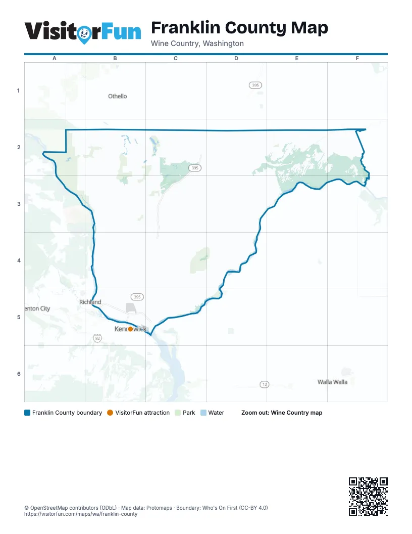
Maps inside Franklin County
1 map inside, from the street map of Franklin County down.
Street index of Franklin County
Each street on the sheet and the grid squares it crosses.
- Thomas S. Foley Memorial HighwayC2, D2, C3, B4, C4, B5
- Lewis and Clark TrailB5, C5
- Pasco-Kahlotus RoadE2, D3, E3, D4, C5, D5
- Pepiot RoadC3, D3
- West Court StreetB5
- Burns RoadB5
- SR 17C2, C3
- Road 68B5
- Broadmoor BoulevardB5
- West Muse RoadB2, D2
- State Route 24A2, B2
- North 20th AvenueB5
- West Lewis StreetB5
- East Ainsworth StreetB5, C5
- East Lewis StreetB5, C5
- South 10th AvenueB5
- North Oregon AvenueB5
- South Oregon AvenueB5
- Road 100B5
- West Ainsworth StreetB5
- State Highway 17B2
- 20th AvenueB5
- SR 24B2
- Glade North RoadB3, B4, B5
- Road 170B3, C3
- SR 260C2, E2
- Eltopia West RoadB4, C4
- Sagehill RoadB2, B3
- West Sagemoor RoadB4
- Kahlotus Lind RoadE2
- Columbia River RoadB4, B5
- West Argent RoadB5
- Muse RoadC2, D2
- Sandifur ParkwayB5
- Chapel Hill BoulevardB5
- North 4th AvenueC2, B5
- Clark RoadB5
- Dent RoadB5
- Burden BoulevardB5
- Road 44B5
- Road 36B5
- East A StreetB5, C5
- Road 84B5
- West A StreetB5
- Road 68 NorthB5
- Sacajawea BoulevardC5
- Booker RoadC2
- North 28th AvenueB5
- East State Route 260E2
- Heritage BoulevardB5, C5
- South 28th AvenueB5
- North Violet AvenueE2
- Lind-Kahlotus RoadE2
- West State Route 260E2
- Court StreetB5
- Blanton RoadC2, C3, C4
- Taylor Flats RoadB3, B4, B5
- Snake River RoadD3, D4
- Russell RoadB3, C3
- Selph Landing RoadB4
- Hoover RoadD2
- Langford RoadC3, C4
- Lind RoadC2, D2
- Sheffield RoadB3, C3
- Overturf RoadC3, D3
- Devils Canyon RoadE2, E3
- East Foster Wells RoadB5, C5
- Hollingsworth RoadB2, A3, B3
- Ringold RoadB3
- Wadsworth RoadD2, E2
- Moulton RoadD3
- Frontier RoadC4
- North Railroad AvenueC2, B4, B5
- Burr Canyon RoadD3, E3
- North Wahluke RoadB2
- Moon RoadC2
- West Sylvester StreetB5
- Wahluke RoadB3
- East Sagemoor RoadB4, C4
- North Commercial AvenueB5, C5
- Ice Harbor RoadC5
- Road 52B5
- Road 60B5
- Road 76B5
- West Clark StreetC2, B5
- Road 108B5
- North Capitol AvenueB5
- West Dogwood RoadB4
- South Old State Route 17C3
- Wrigley DriveB5
- North 5th AvenueC2, B5
- Fanning RoadB4, B5
- West Nixon StreetB5
- Road 64B5
- Madison AvenueB5
- Harris RoadB5
- North 14th AvenueB5
- North 18th AvenueB5
- Klamath Hill RoadB3
- North 7th AvenueB5
- Industrial WayB5
- West Brown StreetB5
- North 3rd AvenueC2, B5
- Convention DriveB5
- West Vineyard DriveB4
- South 5th AvenueC2, B5
- South Columbia AvenueC2
- North Columbia AvenueC2
- North 10th AvenueB5
- First AvenueB3, C3
- South 4th AvenueC2, B5
- Sacajawea Park RoadC5
- North 22nd AvenueB5
- South Road 40 EastC5
- Road 34B5
- Fraser RoadB4, B5
- Easy StreetB5
- East Dock StreetB5, C5
- Road 90B5
- Laporte DriveB4, B5
- East Hillsboro StreetB5
- Kau Trail RoadB5
- Saint Thomas DriveB5
- East Ainsworth AvenueB5, C5
- West Columbia StreetB5
- Shoreline RoadB5
- East Kartchner StreetB5
- Road 36 NorthB5
- Sun Willows BoulevardB5
- North 1st AvenueB5
- South 1st AvenueC2, B5
- Melody LaneB5
- Manton WayC3
- North 26th AvenueB5
- May AvenueC3
- North Rainier AvenueB5
- Convention PlaceB5
- South 6th AvenueC2, B5
- South Maitland AvenueB5
- South 3rd AvenueC2, B5
- North Columbia Industrial WayC2
- South 7th AvenueC2, B5
- North 6th AvenueB5
- North Spokane AvenueE2
- South Johnson RoadC2
- East Weston StreetE2
- South Spokane AvenueE2
- Hollingsworth SpurB2
- Saint Francis LaneB5
- 4th AvenueB5
- North Durham AvenueE2
- Capitol AvenueB5
- Saint Francis DriveB5
- Hendricks RoadB2, C2
- Coyan RoadB2, C2
- Fishook-Elgin RoadD2, D3
- Public Highway 15D2, D3
- Alder RoadB4
- Mountain Vista RoadA2, B2, A3
- McClenny RoadD4
- Essenprise RoadD3
- Blackman Ridge RoadC4, D4
- Eagle Rock RoadC2, C3
- Smith Canyon RoadC3
- East Elm RoadC4
- Coordes RoadC3
- Copp RoadD2
- Greenacres RoadB2, B3
- Neff Jones RoadD3, D4
- Ironwood RoadB3, C3
- Gertler RoadC3, C4
- Hunt RoadD3
- Birch RoadB4
- Wallace Walker RoadE3
- Garfield RoadB3
- Blackburn RoadC2, D2
- Old Secondary State Highway 11AA3, B3
- Reynolds RoadD3
- West Fir RoadB4
- Scooteney RoadB2
- Elm RoadB4
- Albany RoadB2, B3
- Paradise RoadC2
- Glenwood RoadB3
- North Bellevue RoadB3, B4
- Dilling RoadC2
- Gill RoadE2
- Buehler RoadC2
- Warehouse RoadC2
- Dayton RoadB4
- Dogwood RoadB4
- Fir RoadB4, C4
- Miller RoadD2
- Black RoadD2
- Cottonwood DriveB4
- Delaney RoadD2, D3
- Nunamaker RoadE2, F2
- Crestloch RoadB4, C4
- North Coulee RoadB3
- East Vineyard DriveB4, C4
- Piekarski RoadC5
- Haverland-Koontz RoadC3, D3
- Rangeview RoadB2
- Filbert RoadA2, B2
- Juniper Dunes RoadC4, C5
- Nordheim RoadC2, D2
- Phend RoadB4, C4
- McCallum RoadD3
- Myers RoadC2, D2
- Krug RoadC2
- Buffalo RoadB2, B3
- Hoon RoadD2, D3
- Lone Star RoadD2
- Cedar RoadB4
- Astoria RoadC2, C3
- Wilder RoadE2
- Colonial RoadB3
- Falls RoadC4
- Wahluke North AccessA2
- West Klamath RoadB3
- Auburn RoadB3, B4
- Murphy RoadD4
- Pederson RoadD4
- Basin Hill RoadB3
- Mesa-Kahlotus RoadD3
- Harper RoadD3
- Muse DriveC2
- Davin RoadF2
- Hooper RoadB3, B4
- Hope Valley RoadB3, B4
- Merion RoadC2, C3
- Klaus RoadD2
- Kent DriveC3
- Rice RoadD2, E2
- Kruse RoadC4
- Horseshoe RoadB2, C2
- Broxon RoadD2
- Palmer RoadE2
- West Wernett RoadB5
- Perry RoadE2
- Watson RoadD2, E2
- Ringold River RoadB3
- West Henry StreetB5
- Holly DriveB3, C3
- West Pearl StreetB5
- Page RoadD4
- Newport DriveB3, C3
- West Juniper RoadB3
- Bellflower RoadB3
- Columbia River Road NorthB4
- Klamath RoadB3, C3
- Juniper RoadB3
- Havlina RoadC2, D2
- Palouse Falls RoadF2
- Drummond RoadB3
- Largent RoadD3
- Martindale RoadC5
- Curry RoadC2, D2
- Helm DriveB4
- Ash RoadB3
- Joyce RoadC3
- Lewis RoadE2
- Lowe RoadA2, B2
- North Cherry DriveB4
- Rye Grass Coulee RoadC4
- West Marie StreetB5
- Neilson RoadD2
- Peterson RoadC5
- Richview DriveB4, B5
- Stastney RoadC3
- Joy RoadD4
- Bauermeister RoadD3
- West Agate StreetB5
- Basin Slope RoadB3
- West Margaret StreetB5
- West Octave StreetB5
- Klundt RoadD4
- Ione RoadB4
- North Dayton RoadB3
- Settler RoadC2
- Reader RoadD2
- Columbia RoadB3
- Bellevue RoadB4
- Fairfield DriveB4
- Loeber RoadC2, C3
- Ritchards RoadD2, E2
- West Richardson RoadB5
- Cypress DriveB4
- West Park StreetB5
- Farrell RoadC4
- Struthers RoadD2
- East Muse RoadD2
- North Baart RoadB3, C3
- Fircrest RoadB3, B4
- West Bonneville StreetB5
- Ranger DriveB3
- West Ruby StreetB5
- Road 40B5
- Road 48B5
- Herman RoadC5, D5
Places on the map
- Bacchus Vineyard
- Bailie Wildlife Area
- Basin City
- Big Cross
- Big Flat Habitat Management Unit
- Cactus Quarry
- Cameron Nursery
- Camp Lakes
- Cattail Lake
- Chiawana Park
- Columbia Plateau Trail State Park
- Connell
- Dalton Lake
- Dionysus Vineyard
- Eagle Lakes
- Esquatzel Coulee Wildlife Area
- Gamache Vineyard
- Hope Valley Wildlife Area
- Juniper Dunes Wilderness
- Juniper Forest Area of Critical Environmental Concern
- Kahlotus
- Lake Emma
- Lake Kahlotus
- Levey Landing Park
- Lyons Ferry Habitat Management Unit
- Lyons Ferry State Park
- Mesa
- Mesa Lake
- Mesa Lake Wildlife Area
- Oakdell Egg Farms
- Pasco
- Pasco Premix #5
- Pasco Yard
- Richland Bend
- Sacajawea State Park
- Scooteney Park Recreation Area
- Scooteney Reservoir
- Skookum Habitat Management Unit
- Thompson Seeps Wildlife Area
- Windmill Ranch Wildlife Area
Next to Franklin County
- Benton City
- Kennewick map
- Othello
- Richland map
- Walla Walla map
© OpenStreetMap contributors, Open Database License, openstreetmap.org/copyright · Map data: Protomaps · Boundary: Who's On First (CC-BY 4.0); Quattroshapes (CC BY 2.0)















