

Washington map
Okanogan County map
About 44,942 people live here (Census Bureau, 2024 estimate). The sheet's index lists 300 streets; Highway 20, Main Street and Coulee Corridor cross the most grid squares. Things to do inside the boundary: Grand Coulee Dam and Okanogan Country.
Open the map (PDF, US Letter)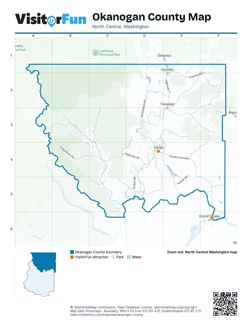
Street index of Okanogan County
Each street on the sheet and the grid squares it crosses.
- Highway 20F2, A3, B3, C3, E3, C4, D4
- Coulee CorridorD4, E4, E5, F5, F6
- Methow Valley HighwayC4, C5
- State Route 20F2, B3, E3, D4
- State Highway 20F2, F3
- Main StreetE1, D2, E2, C3, D3, C4, C5
- River DriveF6
- 2nd Avenue SouthD4
- Riverside AvenueC3, C4
- Industrial WayC5
- Omak Avenue EastD4
- South Whitcomb AvenueE2, E3
- East 6th StreetE3
- Dayton Street SouthD4
- Dayton StreetD4
- Omak AvenueD4
- State Highway 155F6
- Janis BridgeE3
- Whitcomb AvenueE2, E3
- 97th StreetE1
- Highway 7E2, E3
- Old Highway 97D4, D5
- State Highway 17D5
- Westside Chewuch RoadC3
- Old US Highway 97D3, D4
- Twin Lakes RoadC4
- B and O RoadD4
- 2nd Avenue NorthD4
- Riverside DriveD4, C5
- Okoma DriveD4
- 4th AvenueE2, C4, D4
- South Bridge StreetD5
- 7th Street NorthD5
- Main Street NorthD4
- Main Street SouthD4
- White AvenueC4
- Bridge Street NorthD5
- West 4th StreetE3
- 7th Street SouthD5
- West Main AvenueD5
- 12th AvenueE2
- Elmway StreetD4
- Bridge Street SouthD5
- Main AvenueD5
- East Main AvenueD5
- Elm WayD4
- Nighthawk RoadD1
- Loomis-Oroville RoadD1, E1, D2, E2
- Columbia River RoadD4, E4, E5, F5
- Chesaw RoadE1, F1, E2, F2
- Cameron Lake RoadD4, D5
- Twisp River RoadB4, C4
- Havillah RoadE2, E3
- Pine Creek RoadD3, E3
- Toroda Creek RoadF2
- Sinlahekin RoadD2, D3
- Lyman Lake RoadF3, E4, F4
- Tunk Creek RoadD3, E3
- Conconully RoadD3, D4
- Aeneas Valley RoadE3, F3
- North Star RoadD4, D5, F5
- Forest Road 42D3, C4, D4
- Paradise Hill RoadC5, D5
- Omak Lake RoadD4, E4, E5
- Forest Road 51C2, C3
- Kartar RoadE4, E5
- Twisp-Carlton RoadC4
- Monse River RoadD5
- Omak-Riverside Eastside RoadD3, E3, D4, E4
- Wolf Creek RoadB3, C3, C4
- Twisp-Winthrop Eastside RoadC4
- Indian Dan Canyon RoadC5, D5
- Goat Creek RoadB3
- Lost River RoadB3
- Cache Creek RoadF5
- Gold Creek RoadC5
- Patterson Lake RoadB3, B4, C4
- Hungry Hollow RoadE2, F2
- Peter Dan RoadF5, F6
- Molson RoadE1, E2
- Riverside Cutoff RoadD3, D4
- Spring Coulee RoadD4
- Old Riverside HighwayD3, D4
- Fish Lake RoadD3
- Johnson Creek RoadD4
- B and O North RoadD4
- Eastside Chewack RoadC3
- Robinson Canyon RoadD4
- Elmer City Access RoadF5, F6
- Duck Lake RoadD4
- Gold Creek Loop RoadC5
- Bureau of Indian Affairs Road 54E5
- Similkameen RoadD1
- Marina WayF6
- Bide-A-Wee RoadD4
- Monse Bridge RoadD5
- Eastside Oroville RoadE1, E2
- East Chewuch RoadC3
- Kermel RoadD4
- River RoadB3, E3, F5
- Danker Cutoff RoadD4
- Hendrick RoadD4
- Ross Canyon RoadD4
- Miller RoadD4
- Secondary 10A RoadF5, F6
- Crest DriveE1, F6
- Pioneer RoadE1, D5
- Sawtell RoadE1, E2
- Fir StreetE2, F6
- Castle AvenueC3, C4
- Koala DriveD4
- North Malott RoadD4
- Omak Airport RoadD4
- Eastside Chewuch RoadC3
- Forest Road 4200-100C4
- Oak StreetD4
- Central Avenue WestE2, D4
- Central DriveF6
- Broadway StreetD2, D3
- North Main StreetD3
- Pine StreetD4, F6
- Jasmine StreetD4
- Loomis-Oroville HighwayD2
- Hospital WayD5
- Monse Cut Off RoadD5
- Granite Street SouthD4
- Secondary HighwayF5, F6
- South 3rd StreetD5
- Bartlett Avenue WestD4
- Bluff StreetC3
- West 2nd AvenueC4
- Ash Street SouthD4
- C StreetF5
- 9th StreetF5
- Ash Street NorthD4
- Central AvenueE2
- Cherry Avenue WestD4
- West Cliff AvenueD5
- 6th Avenue NorthD4
- County Road 280D4
- Tunk Valley RoadD3
- Cherry StreetE2
- Jay Avenue NorthwestD5
- Palmer AvenueD2
- Cedar Street NorthD4
- Quince StreetD4
- Turners Cutoff RoadE2, F2
- East Jonathan StreetE2, E3
- Norfolk RoadC4
- Oak Street NorthD4
- South 7th StreetD5
- Mead WayF6
- Center StreetC4
- Roosevelt WayF6
- North 5th AvenueD4
- Jay Avenue EastD5
- North 3rd StreetD5
- Eastside Access RoadD4
- Forest Road 37C3, D3
- Forest Road 39C2, C3
- Gold Lake RoadF4, F5
- Toats Coulee RoadC2, D2
- National Forest Development Road 100C2, B3, F3, C4
- National Forest Development Road 200B3, E3, F3, C4, C5
- Omak Mountain RoadE4
- Cold Springs RoadD4, E4, E5
- Bureau of Indian Affairs Road 56E4, F4
- Soap Lake RoadD4, D5
- Bureau of Indian Affairs Road 62E4, F4
- Forest Road 5130B2, B3, C3
- Buttermilk-Libby RoadB4, C4
- Salmon Creek RoadD3, D4
- Bureau of Indian Affairs Road 109E4, F4, F5
- Forest Road 3230E2, F2
- Omaha Lake RoadE4, E5
- Forest Road 33E2, F2
- Antoine Creek RoadC5, C6
- Forest Road 52B3
- Ellemeham Mountain RoadD1, D2, E2
- Horse Spring Coulee RoadD2, D3
- Chewiliken Valley RoadE3
- Harts Pass RoadA2, A3, B3
- Nicholson Creek RoadF1, F2
- Bureau of Indian Affairs Road 77F4, F5
- Rock Lake RoadD3, D4
- Bonaparte Lake RoadF2
- Forest Road 5140B2, C2, C3
- Forest Road 4235C3, C4
- Swanson Mill RoadE2
- National Forest Development Road 5160C2
- Buffalo Lake Road SouthF5
- Loup Loup Canyon RoadD3, D4
- Forest Road 5010C2, C3
- Cape Labelle RoadF3
- Nine Mile RoadE1, E2
- Bureau of Indian Affairs Road 91E4, E5
- Bailey Creek RoadE3, F3
- Bureau of Indian Affairs Road 70F4
- Nealey RoadE2, F2
- Poorman Creek RoadB4, C4
- Wannacut Lake RoadD2
- Chiliwist RoadD4
- National Forest Development Road 5225B3
- Lagrange RoadD5
- Watson Draw RoadC5
- Forest Road 3300-100F2
- Bill Shaw RoadC5
- Black Canyon RoadC5
- National Forest Development Road 4150C4, C5
- National Forest Development Road 41C4, C5
- Bureau of Indian Affairs Road 116F4
- Forest Road 41C4
- Forest Road 4410B4
- McFarland Creek RoadC5
- Forest Road 30E3
- Forest Road 5009-200C3
- Forest Road 3820C2, C3, D3
- Mt Annie RoadF2, F3
- Upper South Fork Gold Creek RoadC5
- Forest Road 5220B3, C3
- Mary Ann Creek RoadE1, F1, F2
- Central Peak RoadF4
- Funk Mountain RoadD2
- French Creek RoadC5
- Siwash Creek RoadE2
- National Forest Development Road 400A3, E3
- McLaughlin Canyon RoadE3
- Forest Road 3240F2
- Delfeld RoadD5
- National Forest Development Road 31F3
- Texas Creek RoadC4, C5
- Frosty Creek RoadF3
- Greenaway RoadD5, E5
- Bear Creek RoadC3, C4
- Forest Road 4235-100C3, C4
- Tunk Mtn RoadE3
- Old Omak LakeE5
- North Fork Gold Creek RoadB4, B5, C5
- South Fork Toats Coulee RoadC2, D2
- J H Green RoadE3
- Pontiac Ridge RoadF2
- Little Bridge Creek RoadB4
- Timm RoadE5
- Forest Road 38D3
- Owhi Lake RoadF5
- National Forest Development Road 260E2, E3
- North Siwash Creek RoadE2
- Bureau of Indian Affairs Road 69E4
- Forest Road 4230C3, C4
- Chopaka RoadD1, D2
- Jack Wells RoadD5
- Dry Gulch RoadE2
- Douglas Mountain RoadD2, D3
- Forest Road 4225C4
- Cameron Lake Loop RoadD4
- Seven Lakes RoadD3
- Bureau of Indian Affairs Road 65F4, F5
- Lookout Mountain RoadC4
- Barnell Meadow RoadE3
- Bureau of Indian Affairs Road 103E4
- Valley RoadD5
- Bureau of Indian Affairs Road 1019E5, F5
- Windy Hill RoadD4
- Forest Road 3107C5, C6
- Davies RoadE1, E2
- Buzzard Lake RoadD4
- Upper Beaver Creek RoadC4
- Ellemeham Ridge RoadD1, D2
- North Lemanasky RoadD2, D3
- National Forest Development Road 300B3, E3, C4
- Forest Road 3000E3, F3
- Libby Creek RoadC4, C5
- Cook Mountain RoadD4
- Antoine Breaks RoadE2
- Timentwa RoadD5, E5
- Cache Creek Cutoff RoadF5
- Lemanasky RoadD2, D3
- Roundabout RoadF3
- Bolster RoadF1
- Bureau of Indian Affairs Road 1014E4
- Forest Service 3120 RoadF3
- Summit Lake RoadE2
- Rendezvous RoadB3, C3
- Old Omak Lake RoadE5
- Joe Moses RoadF5
- Hagood RoadD3
- Plata RoadD5
- Green Lake RoadD4
- Forest Road 31F3
- North End Omak Lake RoadE4
- South Fork Gold Creek RoadC5
- Forest Road 5009-100C3
- Neil Circle South RoadE3, F3
- Bureau of Indian Affairs Road 102E4
- Bench Creek RoadE3
- Elbow Coulee RoadC4
- Forest Road 3235E2
- Park City Loop RoadF4, F5
- Cub Creek RoadB3, C3
- Forest Road 4400-100B4
Things to do on the Okanogan County map
Places on the map
- Aeneas Lake
- Alkali Lake
- Alta Lake
- Alta Lake Campground
- Alta Lake Golf Resort
- Alta Lake State Park
- Bear Creek Golf Course
- Beth Lake
- Big Buck Wildlife Area
- Big Hidden Lake
- Big Twin Lake
- Big Valley Wildlife Area
- Black Lake
- Blue Lake
- Blue Lake Public Access
- Bonaparte Lake
- Bonaparte Meadows
- Carter Mountain Wildlife Area
- Charles And Mary Eder Wildlife Area
- Chesaw Wildlife Area
- Chewuch River Research Natural Area
- Chiliwist Wildlife Area
- Driscoll Island Wildlife Area
- Ellemeham Wildlife Area
- Golden Doe Wildlife Area
- Indian Dan Canyon Wildlife Area
- Lake Chelan-Sawtooth Wilderness
- Loomis Natural Resources Conservation Area
- McLoughlin Falls Wildlife Area
- Methow Wildlife Area
- Omak Airport
- Pasayten Wilderness
- Pateros Wildlife Area
- Pearrygin Lake State Park
- Pogue Mountain Wildlife Area
- Rendezvous Wildlife Area
- Scotch Creek Wildlife Area
- Sinlahekin Wildlife Area
- Texas Creek Wildlife Area
- Tunk Valley Wildlife Area
Next to Okanogan County
- Grand Coulee
- Osoyoos
- Republic
© OpenStreetMap contributors, Open Database License, openstreetmap.org/copyright · Map data: Protomaps · Boundary: Who's On First (CC-BY 4.0); Quattroshapes (CC BY 2.0)















