

Washington map
Sunnyside map
About 16,317 people live here (Census Bureau, 2024 estimate). The sheet's index lists 245 streets; Yakima Valley Highway, South 1st Street and Tacoma Avenue cross the most grid squares. Also on it: Mid Valley Mall, Sunnyside Airport and Sunnyside Athletic Complex.
Open the map (PDF, US Letter)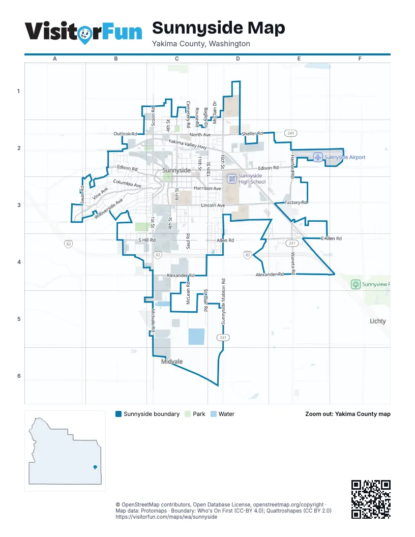
Street index of Sunnyside
Each street on the sheet and the grid squares it crosses.
- Beckner AlleyC1, D1
- Cemetery RoadC1, C2
- East Woodin RoadC1
- Fairview AvenueC1
- Ismo LoopC1
- North 4th StreetC1, C2
- North 6th StreetC1, C2
- Reeves CourtC1, C2
- Rouse RoadC1, C2
- Scoon RoadC1, C2
- Victory WayC1, C2
- Woods RoadC1, C2
- McClain DriveD1, D2
- New Life PlaceD1
- North 16th StreetD1, D2
- Washout RoadD1
- Buena Vista AvenueB2, B3
- Darrin CourtB2
- Dayton DriveB2, B3
- Hogan StreetB2
- Homer StreetB2, C2
- Ivone DriveB2
- Laura AvenueB2
- Maple AvenueB2
- Mayhew StreetB2, B3
- Northwest Crescent AvenueB2, C2
- Olivia StreetB2
- Outlook RoadB2, C2
- Rainbow LaneB2
- Ravine DriveB2, B3
- Ridgeway LoopB2, B3
- San Clemente AvenueB2, B3
- San Mateo DriveB2
- Terry StreetB2, B3
- Thompson DriveB2, B3
- Villa Real DriveB2
- West Edison RoadB2, C2
- Wheeler AvenueB2
- Yakima Valley HighwayB2, C2, D2, D3, E3
- AppleC2
- Arrowsmith AvenueC2
- Bagley DriveC2
- Blaine AvenueC2, D2
- CherryC2
- Chestnut AvenueC2
- Crescent AvenueC2, C3
- Custer AvenueC2
- Decatur AvenueC2, D2
- Doolittle AvenueC2
- East Edison AvenueC2, D2
- Flower StreetC2
- Franklin AvenueC2, D3
- Hamilton DriveC2, C3
- Lappin AvenueC2
- Lookout DriveC2, B3
- Loretta AvenueC2
- North 10th StreetC2
- North 11th StreetC2
- North 1st StreetC2
- North 2nd StreetC2
- North 7th StreetC2
- North 9th StreetC2
- North AvenueC2, D2
- Park DriveC2, C3
- Patrick CourtC2
- PeachC2
- PearC2
- Railroad AvenueC2
- Reeves WayC2
- Rohman StreetC2
- Roosevelt CourtC2, D2
- Sage CourtC2, D2
- South 10th StreetC2, C3
- South 11th StreetC2, C3
- South 12th StreetC2, C3
- South 1st StreetC2, C3, C4
- South 2nd StreetC2, C3
- South 3rd StreetC2
- South 5th StreetC2, C3
- South 6th StreetC2, C3
- South 7th StreetC2, C3
- South 8th StreetC2, C3
- South 9th StreetC2, C3
- Spruce AvenueC2
- Stackhouse StreetC2
- Sunnyside AvenueC2, C3
- Tacoma AvenueC2, C3, D3
- Terrace DriveC2
- UptownC2
- Walnut AvenueC2
- Warehouse AvenueC2
- Weatherwax AvenueC2
- Yakima AvenueC2, D2
- Zillah AvenueC2
- Barnard BoulevardD2
- Dawn AvenueD2
- Denson AvenueD2
- East Edison RoadD2, E2
- Eastway DriveD2
- Federal WayD2
- Franklin CourtD2
- Gregory AvenueD2
- Morgan RoadD2
- North 13th StreetD2
- North 14th StreetD2
- North 15th StreetD2
- Oak StreetD2
- Reith WayD2, E2
- Sheller CourtD2
- Sheller RoadD2
- South 13th StreetD2, D3, D4
- South 14th StreetD2, D3, D4
- South 15th StreetD2, D3, D4
- South 16th StreetD2, D3
- Hanford RoadE2, E3
- Van Nutley DriveE2
- Cherry AvenueA3, B3
- Columbia AvenueA3, B3, C3
- North Countryview CourtA3
- Ridgeview CourtA3
- Sunset PlaceA3, B3
- Swan RoadA3
- Upland DriveA3, B3
- West Grandview AvenueA3, B3
- West Ivy CourtA3
- West Riverside AvenueA3, B3, C3
- Ann AvenueB3
- Arthur StreetB3
- Ayrshire StreetB3, B4
- Cabot LaneB3
- Canadienne StreetB3, B4
- Coral LaneB3
- Grandview AvenueB3, C3
- Grending AvenueB3
- Guersey StreetB3, B4
- Heffron RoadB3
- Heffron StreetB3
- Holstein AvenueB3
- Jersey StreetB3, B4
- Julie StreetB3
- Lander AvenueB3
- Lander CourtB3
- Louise WayB3
- Madison AvenueB3, C3
- Maridan DriveB3
- Marj WayB3
- Merrick AvenueB3, C3
- Nicolai AvenueB3, C3
- Orchard AvenueB3
- Owen StreetB3
- Peach AvenueB3
- Riverside TerraceB3
- Rossier StreetB3
- Sandy StreetB3
- Skyline DriveB3
- Southwest Crescent AvenueB3, C3
- Spaulding AvenueB3, C3
- Taylor StreetB3
- Thill AvenueB3, C3
- Vine AvenueB3
- Vista AvenueB3
- Washington CourtB3, B4
- West Crescent DriveB3
- West Lincoln AvenueB3, C3
- West Madison PlaceB3
- Woodward StreetB3
- 13th StreetC3, C4, D4
- Apple LaneC3, D3
- Barnes CourtC3
- Bridge StreetC3
- Carnation DriveC3
- Cedar AvenueC3
- East Lincoln AvenueC3, D3, E3
- East Parkland DriveC3
- Grant AvenueC3, D3
- Grape LaneC3, D3
- Harrison AvenueC3, D3
- Hawthorne DriveC3
- Hemlock AvenueC3
- Ida Belle StreetC3, D3
- Jackson AvenueC3, D3
- Kearney AvenueC3, D3
- Linden WayC3
- Maple WayC3
- Miller AvenueC3
- Newhouse AvenueC3
- Olive AvenueC3
- Otis AvenueC3
- Pear LaneC3, D3
- Saul RoadC3, C4
- South 4th StreetC3, C4
- South StreetC3, D3
- Valley View LaneC3
- Aden AvenueD3
- Alphabet LaneD3
- Bountiful AvenueD3, D4
- East Madison AvenueD3
- Golden StreetD3
- Harvest PlaceD3, D4
- Hilzer AlleyD3
- Ida Belle LaneD3
- Irving AvenueD3
- Johnson AvenueD3
- Kristin AvenueD3
- Mabton Sunnyside RoadD3, D4
- South AvenueD3
- Van DeGraaf BoulevardD3
- Alda StreetE3, D4, E4
- East Allen RoadE3, E4
- Factory RoadE3
- Kraft StreetE3
- Linn StreetE3, E4
- North Hanford RoadE3
- Waneta RoadE3, E4
- Cascade WayB4
- McBride StreetB4
- South Hill RoadB4, C4
- Wells RoadB4
- Alexander RoadC4, D4, E4
- Allen RoadC4, D4, E4
- Asparagus LaneC4, D4
- Emerald RoadC4
- Midvale RoadC4, C5, C6
- Mint LaneC4, D4
- North McLean RoadC4
- South McLean RoadC4, C5
- St. Clair RoadC4, C5
- Thornton RoadC4, D4
- Cascade LoopD4
- Centennial AvenueD4
- East Thornton RoadD4
- Julia AvenueD4
- Liberty LaneD4
- Penn AvenueD4
- Saaz LaneD4
- Simcoe AvenueD4
- Braden RoadE4
- Chukar LaneE4
- Clyde CircleE4
- Covey LaneE4
- Picard PlaceE4
- Quail LaneE4
- Wesley WayE4
- Port DriveC5
- Sunnyside Mabton RoadD5
Places on the map
- Apostolic Assembly - Puerta de Cielo
- Astria Sunnyside Hospital
- Best Western Plus Grapevine Inn
- Big 5 Sporting Goods
- Calvary Lutheran Church
- Carl's Jr.
- Central Park
- Chief Kamiakin Elementary School
- Clyde Circle
- Columbia Bank
- Community Dental Care
- Cornerstone Assembly of God
- Denny's
- El Buen Pastor
- Fiesta Foods
- First Baptist Church
- First Church of Christ
- Free Methodist Church
- Grand Cinemas
- Habitat for Humanity ReStore
- HAPO Community Credit Union
- Harrison Hill
- Harrison Middle School
- Iglesia de Santidad Pentecostes
- Jehovah's Witnesses Hall
- Mid Valley Mall
- Pioneer Elementary School
- Saint Josephs School
- Sierra Vista Middle School
- South Hill Park
- Sun Valley Elementary School
- Sunnyside Airport
- Sunnyside Athletic Complex
- Sunnyside Christian School
- Sunnyside City Hall
- Sunnyside Community Library
- Sunnyside High School
- Sunnyside Post Office
- Walmart Supercenter
- Washington Elementary School
Next to Sunnyside
- Lichty
© OpenStreetMap contributors, Open Database License, openstreetmap.org/copyright · Map data: Protomaps · Boundary: Who's On First (CC-BY 4.0); Quattroshapes (CC BY 2.0)















