

Washington map
Walla Walla County map
About 62,068 people live here (Census Bureau, 2024 estimate). The sheet's index lists 300 streets; State Route 124, Lyons Ferry Road and Old Highway 12 cross the most grid squares. Also on it: McNary National Wildlife Refuge, Arthur C. Rempel Nature Area and Ayer Boat Basin.
Open the map (PDF, US Letter)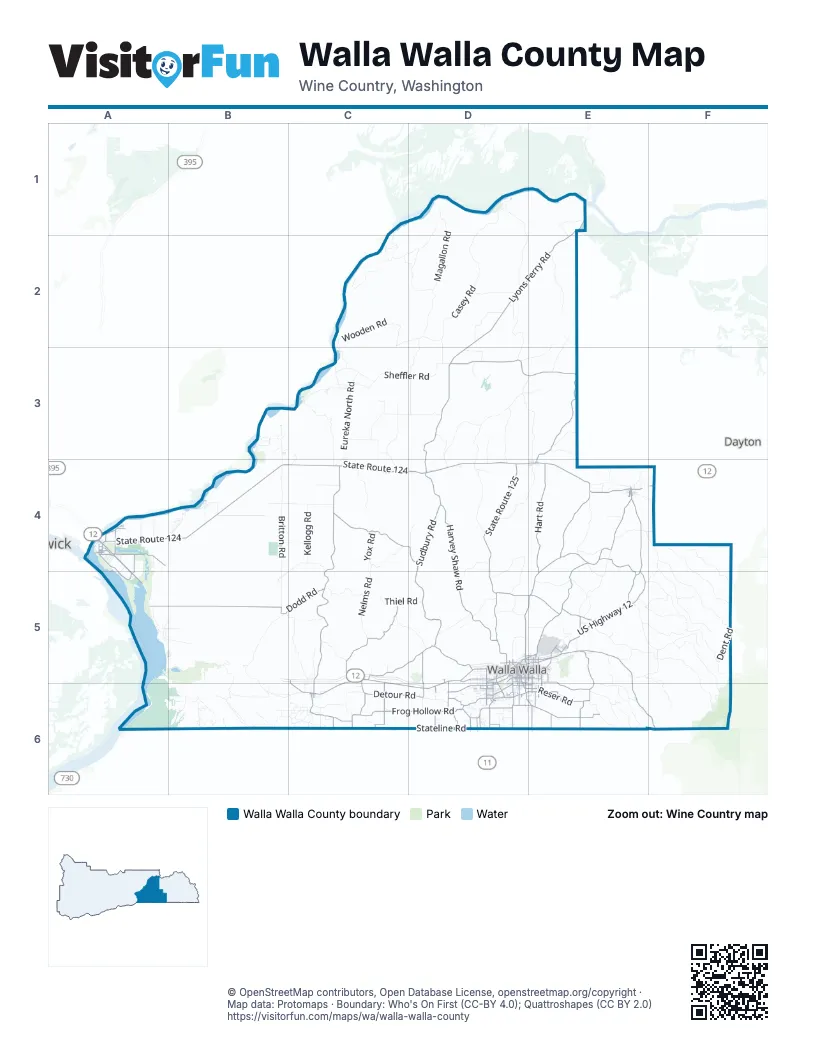
Maps inside Walla Walla County
1 map inside, from the street map of Walla Walla County down.
Street index of Walla Walla County
Each street on the sheet and the grid squares it crosses.
- State Route 124A4, B4, C4, D4, E4
- US Highway 12E4, E5
- Mill Creek RoadE5, E6, F6
- Lewis and Clark TrailA4, A5
- State Highway 124E4
- East Isaacs AvenueD5, E5
- West Rose StreetD5
- Northeast Myra RoadD5, D6
- Main StreetA4, E4, C6
- West Pine StreetD5
- North 9th AvenueD5
- Preston AvenueE4
- South 9th AvenueD5, D6
- Southeast Myra RoadD6
- Coppei AvenueE4
- South Myra RoadD6
- East Rose StreetD5
- East Second StreetE4
- West 2nd StreetE4
- West Second StreetE4
- Oregon-Washington HighwayD6
- Lyon's Ferry Ramp RoadD4
- Lyons Ferry RoadE1, D2, E2, D3, D4
- Touchet North RoadC4, C5, C6
- Middle Waitsburg RoadE4, D5, E5
- State Route 125D4, D5
- Sudbury RoadD4, D5
- Harvey Shaw RoadD4, D5
- Old Highway 12C5, D5, C6, D6
- Lower Waitsburg RoadE4, D5, E5
- Stateline RoadC6, D6, E6
- Lower Dry Creek RoadC5, D5
- Hanson LoopA4, A5
- Reser RoadD6, E6
- Russell Creek RoadE5, E6
- Old Milton HighwayD6
- Gardena RoadC6
- Five Mile RoadE5, E6
- Wallula AvenueD5
- East Alder StreetD5, E5
- Heritage RoadD5
- Mojonnier RoadD6
- South Wilbur AvenueE5, E6
- Taumarson RoadD6
- Plaza WayD6
- Whitman StreetD5, E5
- South 2nd AvenueD5, D6
- West Poplar StreetD5, D6
- South Howard StreetD5, D6
- School AvenueE5, E6
- Pleasant StreetD5, E5
- Fern AvenueE5, E6
- South College AvenueD6
- Touchet-Gardena RoadC6
- Bryant AvenueD5, E5
- North 13th AvenueD5
- Southeast Larch AvenueD6
- Southeast 12th StreetD6
- East Melrose StreetD5, E5
- East Chestnut StreetD5, E5
- West Chestnut StreetD5
- The Dalles Military RoadD6
- Burrows RoadC6
- South Park StreetD5
- East Whitman DriveD6
- South Palouse StreetD5
- A StreetE5
- West Tietan StreetD6
- Northeast C StreetD5, D6
- West Alder StreetD5
- North Clinton StreetD5
- Second AvenueA4
- West Main StreetD5
- South Gose StreetD5
- North Wilbur AvenueE5
- Walnut StreetA4, E4, C6
- North Roosevelt StreetE5
- North Tausick WayE5
- East Tietan StreetD6, E6
- Prospect RoadD6
- North 2nd AvenueD5
- East Main StreetD5
- Southeast Lamperti StreetD6
- North College AvenueD5, D6
- South Roosevelt StreetE5
- West Prospect RoadD6
- East Poplar StreetD5
- North Palouse StreetD5
- South Tausick WayE5
- Gateway RoadA4
- Spalding RoadD5, D6
- Airport RoadE5
- Southeast Meadowbrook StreetD6
- Northeast Larch StreetD6
- Interchange RoadE5
- Freewater HighwayD6
- Dalles Military RoadD6
- Smith Springs RoadD3, E3, E4
- Dodd RoadA5, B5, C5
- Woodward Canyon RoadC5
- Luckenbill RoadC4, D4
- Frog Hollow RoadC6, D6
- Hart RoadE4, E5
- Cottonwood RoadD6, E6
- Valley Grove RoadD5, E5
- Detour RoadC6, D6
- East Humorist RoadA4
- Foster RoadE6
- Stonecipher RoadE4, E5
- West Whitman DriveD6
- Smith RoadE5
- Lewiston RoadE5
- Frenchtown RoadD5, D6
- South 3rd AvenueD5, D6
- Ferris RoadE4
- McDonald RoadC5, C6
- Quincy RoadA4, A5
- Last Chance RoadD5, D6
- Peppers Bridge RoadD6
- Lake RoadA4
- Mc Donald RoadC6
- Powerline RoadE6
- Lowden-Gardena RoadC6
- Beet RoadD6
- Braden RoadD6
- East Sumach StreetD5, E5
- Mission RoadD6
- Valley Chapel RoadD6
- Sapolil RoadE5
- Boyer AvenueD5, E5
- West Sunset DriveA4
- Melrose StreetE5
- Locher RoadD6
- South 4th AvenueD5, D6
- West Maple StreetA4, D5
- Lowden RoadC5, C6
- Kendall RoadE6
- West Rees AvenueD5
- Hood RoadE6
- Berney DriveE5
- South Division StreetE5
- Orchard StreetE4, D5
- West Humorist RoadA4
- West Langdon RoadD6
- West Cherry StreetD5
- County Road 448D6
- Abbott RoadD6, E6
- Jantz RoadA4
- Burlingame RoadC6
- G StreetE4, E5
- South 1st AvenueD5
- East Sunset DriveA4
- Southwest 4th StreetD6
- J. B. George RoadD6
- North 4th AvenueD5
- Country Club RoadD6
- Wellington AvenueE5
- Chase AvenueD5
- Paradise DriveA4
- East Douglas AvenueE5
- Springdale RoadD6
- Southeast 4th StreetD6
- Sweagle RoadD6
- East Langdon RoadD6, E6
- South Clinton StreetD5
- Fifth AvenueA4
- North 5th AvenueD5
- East Rees AvenueD5
- North 3rd AvenueD5
- Bridge StreetE5
- Fourth AvenueA4
- Sheridan RoadD6
- Lower Hogeye RoadF4
- Larson RoadD6
- East Oak StreetD5
- Snake River DriveA4
- Burggraff RoadD6
- North Spokane StreetD5
- North Colville StreetD5
- Southeast Ash AvenueD6
- South 5th AvenueD5
- South Colville StreetD5
- Cherokee StreetD5
- Blue Mountain DriveE5
- Southwest Academy WayD6
- North Pettybone StreetE5
- North Rose StreetD5
- South Spokane StreetD5
- Winesap RoadD6
- Rencken RoadD6
- Southwest Hussey StreetD6
- Lower Monumental RoadC1, C2, D2, D3
- Biscuit Ridge RoadE5, F5, F6
- Casey RoadD1, D2
- Wooden RoadC2, D2, C3
- Sheffler RoadC3, D3
- Britton RoadB4, B5
- Lewis Peak RoadE5, F5
- Ayer RoadD1, D2, E2
- North Fork Coppei RoadF4, F5
- Blacksnake Ridge RoadF5, F6
- South Fork Coppei RoadF4, F5
- Eureka North RoadC3, C4
- Magallon RoadD1, D2
- Piper Canyon RoadD3, E3, D4
- Jasper Mountain RoadF4, F5
- Spring Valley RoadD4, D5
- C M Rice RoadC3, C4
- Spring Creek RoadE5, F5
- Barstow RoadD2, D3
- Donnelly RoadD3, D4
- Harsell RoadD2, D3
- Nelms RoadC4, C5
- Skyrocket RoadD3, E3, E4
- Pettyjohn RoadD4
- Byrnes RoadB5, B6, C6
- Hatch Grade RoadA5, A6, B6
- Brown RoadD4, E4
- Nine Mile Canyon RoadB5
- McFeely RoadD3, D4
- Whiskey Creek RoadF4, F5
- Scott Station RoadC2
- Ash Hollow RoadC5
- Canyon Bottom WayE2
- Miller RoadE4
- Adkins RoadB4, C4
- Greenville RoadC3, C4
- Moorehead RoadC3, D3
- Fishhook Park RoadB3, B4
- Scenic Loop RoadE6
- Kellogg RoadC4
- Sims RoadC5
- Klicker Mountain RoadE5, F5, F6
- Clodius RoadE4, E5
- Mormon Grade RoadE6
- Seaman RoadE5, F5
- Babcock RoadC3
- Lamar RoadC4, D4
- Van Walkley RoadB4
- Mud Creek RoadE5, F5
- Guy Fine RoadC5, D5
- Welch RoadD2
- Thiel RoadC5, D5
- Simmons RoadC3, C6
- Davidson RoadD2
- Uptown RoadC3
- Van Hollebeke RoadC3
- North Shore RoadA5, B5
- Waggoner RoadE5
- Struthers RoadC4
- Barney RoadC6
- Johnson RoadB5, C5
- Hindman RoadB5, B6
- Pike Peak RoadE6
- Cochran RoadD4, D5
- Bolles RoadE4
- Waston Loop RoadB6, C6
- Joe Barker RoadE1, E2
- Manuel Hollow RoadE2, E3
- McFall RoadC4
- Blue Creek RoadE5, F5
- Braden Ranch RoadB6
- Scott RoadF5
- Loney RoadD5
- Dent RoadF5
- Badger Hollow RoadE2, D3, E3
- Martin RoadE5
- McKay Grade RoadE6
- Yox RoadC4
- Legrow RoadC5
- Monument DriveA4, B4
- Sand Pit RoadC6
- Riggs RoadB6, C6
- Pipeline DriveB6
- Whitetail RoadD1, D2
- Vansycle Bluff RoadB6
- Robison Ranch RoadD5
- Bergevin Springs RoadD5
- Dague RoadD5
- Seven Mile RoadE5, E6
- Wiseman RoadD3
- Coppei RoadE4, F4
- Clancy RoadE5, F5
- Conrad RoadC5
- Gluck RoadC4, B5, C5
- Shoreline RoadB4
- Fountain Springs RoadE3
- Londagin RoadE4
- Gerking RoadE4
- Pickard RoadD3
- Gardena Creek RoadC6
- Millrace RoadE4, F4
- Bundy Hollow RoadF4
- Lower Whetstone RoadE3
- Stovall RoadD6
- Ogden RoadA5, B5
- Emerald RoadA4
- Evans RoadE5
- Island View RoadA4
- Ruby Bluff RoadB6
Places on the map
- Arthur C. Rempel Nature Area
- Ayer Boat Basin
- Bennington Lake
- Blue Mountain Vineyard
- Burbank
- Burbank Slough
- Charbonneau Park
- College Place
- Curlew Pond
- Dixie
- Fort Walla Walla Park
- Garrett
- Hood Park
- Lake Herbert G West
- Lake Sacajawea
- Lake Wallula
- Les Collines
- Matthews Recreation Area
- McDonald Bridge Wildlife Area
- McNary National Wildlife Refuge
- Mill Creek Recreation Area
- Pepper Bridge
- Pheasant Creek Golf Course
- Prescott
- Shoreline Road Recreation Area
- Smith's Harbor
- Spring Valley
- Swegle Road Wildlife Area
- Touchet
- Veterans Memorial Golf Course
- Waitsburg
- Walker Habitat Management Unit
- Walla Walla
- Walla Walla East
- Walla Walla Town Center
- Wallula
- Washington State Penitentiary
- Waterbrook Estate Vineyard
- West Millet Pond
- West Woodland Pond
Next to Walla Walla County
- Dayton
- Pasco map
© OpenStreetMap contributors, Open Database License, openstreetmap.org/copyright · Map data: Protomaps · Boundary: Who's On First (CC-BY 4.0); Quattroshapes (CC BY 2.0)















