

Washington map
West Richland map
About 18,820 people live here (Census Bureau, 2024 estimate). The sheet's index lists 300 streets; Keene Road, West Van Giesen Street and Bombing Range Road cross the most grid squares. Also on it: West Richland Golf Course, Paradise Business District and Park at the Lakes.
Open the map (PDF, US Letter)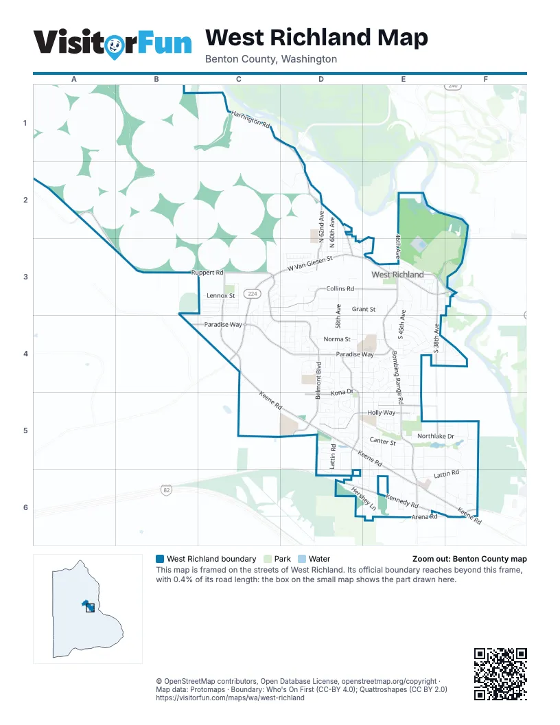
Street index of West Richland
Each street on the sheet and the grid squares it crosses.
- Keene RoadC3, C4, C5, D5, E5, E6, F6
- West Van Giesen StreetC3, D3, E3, F3, C4
- Van Giesen StreetF3
- Bombing Range RoadE3, E4, E5, E6
- Belmont BoulevardC3, C4, D4, D5
- Paradise WayB4, C4, D4, E4
- Kennedy RoadD6, E6, F6
- Harrington RoadC1, D1, D2
- Grosscup BoulevardD2, D3
- Arena RoadE6
- Dallas RoadE6
- East Kennedy RoadD6
- Ruppert RoadA2, A3, B3, C3
- Collins RoadC3, D3, E3
- South Highlands BoulevardD4, D5, D6
- South 38th AvenueE3, E4, E5
- Holly WayD5, E5
- North 62nd AvenueD2, D3
- Kona DriveD4, D5
- Mount Adams View DriveE5
- Fallon DriveE3
- Fallon PlaceE3
- Twin Bridges RoadD1
- West Lattin RoadD5, D6, E6
- South 58th AvenueD3, D4
- Grant StreetD3, E3
- Northlake DriveE5, F5
- Everett StreetD3, E3
- Blue Heron BoulevardD4, E4
- South 54th AvenueD3, D4
- East Lattin RoadE6, F6
- Laurel DriveD4, E4
- Norma StreetD4, E4
- Desert View DriveD3
- Canal DriveD2, D3, E3
- Crab Apple CircleD4, D5
- Ironton StreetD4, E4
- South 45th AvenueE3, E4
- North 61st AvenueD2, D3
- Fern LoopD3, E3
- Canter StreetD5, E5
- Chukar DriveD4, E4
- Hickory AvenueD5
- Polo Greens AvenueE5, E6
- King DriveE4
- Cobalt DriveD4
- Kilawea DriveD4
- Hershey LaneD6, E6
- Equestrian DriveE5, E6
- Melinda DriveD4, E4
- Desert Dove DriveD5, E5
- Austin DriveE3
- Eastlake DriveF5, F6
- Quartz AvenueD3, D4
- Bing StreetE4, F4
- Glenbrook LoopD5, D6
- Ironton DriveE4
- North 60th AvenueD2, D3
- Southlake DriveE5, F5
- Thebes StreetC3, C4
- Sunshine AvenueD4
- Cyprus LoopD3
- James StreetD3
- Maple LaneE4
- Oasis StreetD4
- Cardinal Peak StreetC3
- Haag StreetD3
- Lennox StreetC3
- Sand Hill DriveD2
- Cascade DriveF6
- Clark CourtF5
- North 59th AvenueD2, D3
- Deer StreetD3
- Monica StreetD5, E5
- Hampton DriveE3, E4
- Amber AvenueD4
- Andalusian StreetE4, F4
- Marble StreetC4, D4
- Watkins WayE5, E6
- Curtis DriveD5, E5, E6
- Athens DriveC3
- North 46th AvenueE2, E3
- South 50th AvenueE3, E4
- Diamond Head WayD4, D5
- Queen StreetE4
- Shale StreetD4
- Hummingbird LaneE4, D5, E5
- Westlake DriveE5, E6
- Iris StreetE5
- Rose StreetE5
- Pinehurst StreetD5, E5
- Rhododendron CircleC4
- Onyx AvenueD4
- Crane DriveD5, E5
- Albion StreetC4
- Meyers StreetD3
- Morrison StreetD3
- Orchard StreetE4, F4
- Thynewood LoopD5
- Ferrero DriveD6, E6
- Blue Jay LaneD4, E4
- Dove LaneE4
- Teak LaneD5
- Spirea DriveD5, E5
- Gray StreetD2
- Kenra LoopD6, E6
- Kiger StreetE4
- Timberline DriveD5
- South 41st AvenueE3
- Tamarack RoadE4
- Lanay StreetD5
- Rosencrans StreetE4
- Northview LoopD3
- Juneberry DriveD5
- Paint AvenueE4
- Warbler LaneD5
- Chicory DriveD5
- Ballard LoopC3
- Blanchard LoopC3
- Oleander StreetD5
- Mount Daniel DriveF6
- Diamond DriveD4
- Tatoosh AvenueC3
- Pinnacle DriveD3
- Kendall WayE5
- Chelan DriveE3
- Lexington StreetE5
- Polo WayE5
- Pheasant LaneE4
- Velonia DriveD5, D6
- Aspen DriveD5
- South 39th AvenueE3
- Norma LoopE4
- Morab StreetE5
- Nicholas LaneF4
- Meridian AvenueE4, E5
- Creer WayC3, C4
- Thrush LaneE5
- Astoria RoadD3
- Champion AvenueE5
- Hibiscus StreetE5
- Peony StreetE5
- Jade AvenueD4
- West Lattin CourtE6
- Ficus DriveD5
- North 58th AvenueD2, D3
- Hazelwood DriveE5, E6
- Westview LoopD3
- Forsythia StreetE5
- South 40th AvenueE3
- Maplewood AvenueD4
- Caspian PlaceD3
- Gardner StreetC3
- Rocky Mountain RoadE6, F6
- Chris StreetD5, E5
- Mount Challenger DriveF6
- Waylon DriveC3, C4
- Fernow StreetC3
- Ranchland LaneC4
- Argos StreetC3, D3
- Bedrock LoopC3
- Royal Palm AvenueD5
- Willowbend StreetD5
- North 69th AvenueD3
- Paso Fino StreetE5, F5
- Hove StreetD3
- Friesian CourtE5
- Jamison StreetD2
- North 68th AvenueD3
- Candy Mountain AvenueE6
- Towhee LaneE4, E5
- Mulberry DriveD5
- Hilltop View AvenueD3, D4
- Milky WayE6
- Nelson StreetD3
- Kristin DriveE5
- Corsica StreetC3
- South 44th AvenueE4
- Pikes Peak DriveD3
- Whitestone StreetC4, D4
- South 47th AvenueE4, E6
- Tennessee Walker AvenueF5
- Leilani DriveD4
- Aloha DriveD4
- Remmel StreetC3
- Kirkwood LaneD5
- Duke LaneC3, C4
- Poppy StreetE5
- Andes AvenueC4
- Arlington DriveE3
- Grant LoopE3, F3
- Primrose StreetE5
- Beechwood StreetD5
- Bluewood StreetD4
- Harstine AvenueC4
- Fire Mountain RoadF6
- Ala Moana WayD4
- Galena StreetD4
- Daisy StreetE5
- Cooperative WayC4
- Crown DriveE3
- Bluet DriveD5
- Snowgrass AvenueC3
- Dodge StreetE3, F3
- Seahawk DriveD4
- Mazzard AvenueE4, F4
- Eastlake CourtF5
- Grapevine CourtC3
- Donstance AvenueC3
- Fortress StreetC3
- South 37th AvenueE3
- Annapurna AvenueC3
- Backwood StreetD4
- Glen Hill AvenueD3
- Gilbert StreetC3
- Mountain Meadow RoadE6
- Carefree LoopE5
- Ironwood AvenueD4
- Purcell AvenueC3
- Elmwood AvenueD4
- Losino AvenueE5
- Opal StreetD4
- Ithaca StreetC3
- Royal Crest Loop PrE3
- Valdez CourtE6
- South 46th AvenueE3
- Madrona LoopD5
- Mockingbird CourtE5
- Platinum PlaceD4
- Phoebe LaneD4
- Thrush CourtE5
- Grove CourtE6
- Polaris StreetD4
- Woodford LaneC3
- Sugarplum AvenueD5
- Wegener Private Road NortheastB3
- 435 Private Road NortheastB3
- Birchwood StreetD4
- Fargo StreetE3
- South 48th AvenueE3
- 423 Private Road NortheastB3
- Osprey LaneE4, E5
- Angel Lake CourtE6
- Briarwood LaneD5
- Butte StreetE3
- Killdeer CourtE4
- Webster AvenueE5, E6
- Southlake CourtE5
- Walton PlaceC4
- Sun Lake DriveE6
- Echo StreetD3
- North 58th PlaceD3
- Brook CourtE6
- Thompson CourtE4
- Mineral StreetD4
- Mount Challenger CourtE6, F6
- Washington CourtE4, E5
- Mountain Meadow CourtE6
- North 64th AvenueD3
- Optimum DriveE4
- Twinlake CourtE6
- Grouse DriveE4
- West Robin CourtE4, E5
- Pepperwood AvenueD5
- East Mountain RoadF6
- Lupine StreetE5
- Reeses LaneE6
- Goldfinch CourtE4
- South 42nd PlaceE3
- Napoli StreetC3
- Broadview DriveE4
- Fern StreetD3
- Sparrow CourtE4
- Sully LaneC3, D3
- Mallard CourtE4
- Sirron AvenueF6
- Ala Wai CourtD4
- Polaris CourtD4
- Blackthorn CourtC4
- South 35th AvenueF3
- Elm RoadE3
- Mount Stuart CourtF6
- Rouchelle LaneE4
- Titan AvenueC3
- North Victoria CourtE5
- Lilac StreetE5
- Noble CourtD4
- Valhalla LoopE3
- Clearlake CourtF5
- Jennylake DriveE6
- Oneida CourtB4
- Sapphire StreetD4
- Westlake CourtE5
- Augusta StreetE3
- Wallace CourtD4
- Lakeside LaneF5
- Lindenwood AvenueD4
- Royalty LaneE3
- Alderlake CourtE6
- Kalakaua CourtD4
Places on the map
- Benton County Fire District #4
- Bombing Range Sports Complex
- Burris Auto Repair
- Chevron
- Church of Jesus Christ of Latter-Day Saints Meeting House
- Circle K
- Coyote Community Park
- Desert Sky Elementary School
- Enterprise Middle School
- Enterprise Neighborhood Park
- Flat Top Community Park
- Flat Top Hill
- Gesa Credit Union
- Grace and Truth Community Church
- HAPO Community Credit Union
- Heritage Bible Church
- Ideal Mini Storage
- Islamic Center of Tri Cities
- Kadlec Clinic
- Kadlec Clinic Primary Care
- Kennedy Center Mall
- Leona Marshall Libby Middle School
- Mister Car Wash
- Northwest Premier
- Paradise Business District
- Paradise Neighborhood Park
- Park at the Lakes
- Paul Keith Wetland Reserve
- Red Mountain RV Park
- Rocket Mart
- Sand Hill
- Sergeant Dietrich Schmieman Post Office Building
- Shell
- South Highlands Community Park
- Tapteal Elementary School
- The Church of Jesus Christ of Latter-day Saints
- The Heights Park
- The Wash Shop
- West Richland Golf Course
- Yakima River Gateway Park
© OpenStreetMap contributors, Open Database License, openstreetmap.org/copyright · Map data: Protomaps · Boundary: Who's On First (CC-BY 4.0); Quattroshapes (CC BY 2.0)















