

Washington map
Yakima map
About 97,390 people live here (Census Bureau, 2024 estimate). The sheet's index lists 300 streets; West Washington Avenue, Tieton Drive and West Yakima Avenue cross the most grid squares. Things to do inside the boundary: Yakima Valley.
Open the map (PDF, US Letter)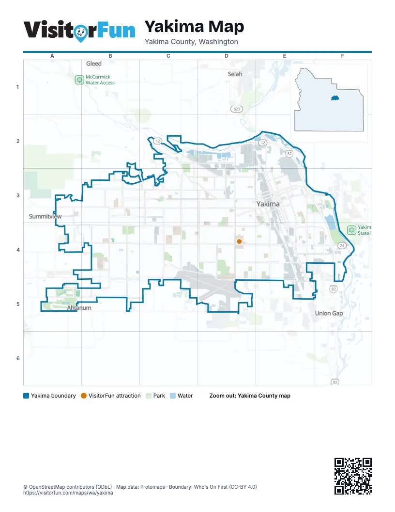
Street index of Yakima
Each street on the sheet and the grid squares it crosses.
- Summitview AvenueA3, B3, C3, D3
- West Washington AvenueC4, D4, B5, C5, D5, E5
- West Nob Hill BoulevardB4, C4, D4, E4
- West Yakima AvenueA3, B3, C3, D3, E3
- 40th AvenueC2, C3, C4
- South 1st StreetE3, E4, E5, F5
- South 16th AvenueD3, D4, D5
- South 72nd AvenueB3, B4, B5
- North 16th AvenueD2, D3
- North 1st StreetE2, E3
- East Nob Hill BoulevardE4, F4
- East Yakima AvenueE3, F3
- State Route 24F4
- North 72nd AvenueB3
- Selah RoadE2
- North 40th AvenueC2
- West Valley Mall BoulevardD5, E5
- Terrace Heights WayF3
- Terrace Heights DriveF3
- Tieton DriveE3, A4, B4, C4, D4, E4
- West Lincoln AvenueB3, C3, D3, E3
- West Mead AvenueB4, D4, E4
- Fruitvale BoulevardC2, D2, D3
- South 64th AvenueB3, B4, B5
- South 3rd AvenueE3, E4
- South 24th AvenueD3, D4, D5
- Ahtanum RoadA5, D5
- South 5th AvenueE3, E4
- South 80th AvenueB3, B4, B5
- West Walnut StreetA3, C3, D3, E3
- Zier RoadA4, B4
- North 5th AvenueD3, E3
- Wide Hollow RoadA4, B4
- East Mead AvenueE4, F4
- East Washington AvenueE5
- East Walnut StreetE3
- South 96th AvenueA3, A5
- North 96th AvenueA3
- West Division StreetE4
- Division StreetE4
- West Chestnut AvenueA3, B3, C3, D3, E3
- Englewood AvenueB3, C3, D3
- Occidental RoadA5, B5
- South 10th AvenueD3, D4, D5
- River RoadC2, D2
- South Fair AvenueE3, E4
- Coolidge RoadA5, B5, C5
- Scenic DriveB3, C3
- South 7th AvenueD3, E3, E4, E5
- South 6th StreetE3, E4
- South 88th AvenueA3, A4, A5
- South 32nd AvenueD3, D4
- South 18th StreetF3, F4
- South 36th AvenueC3, C4, C5
- South 48th AvenueC3, C4
- Martin Luther King Jr. BoulevardD3, E3
- North 2nd StreetE2, E3
- East Viola AvenueE4, F4
- North 3rd StreetE2, E3
- Powerhouse RoadC3, D3
- North 34th AvenueC2, C3
- Castlevale RoadC3, D3
- East Chestnut AvenueE3, F3
- South 44th AvenueC3, C4
- South 75th AvenueB4, B5
- North 20th AvenueD2, D3
- East Beech StreetE3, F3
- North 6th StreetD2, E2, E3
- North 66th AvenueB3
- Pacific AvenueE4, F4
- West Powerhouse RoadC2
- North Front StreetE2, E3
- South 3rd StreetE3, E4
- East Lincoln AvenueE3
- North 25th AvenueD2, D3
- North 74th AvenueB3, B5
- North 56th AvenueC3
- North 32nd AvenueD2, D3
- South 2nd StreetE3, E4
- North 80th AvenueB3
- North 58th AvenueB3, C3
- East D StreetE3
- North 48th AvenueC3
- South 56th AvenueC3, C4, C5
- North 3rd AvenueE3
- North 8th StreetE3
- South Front StreetE3, E4
- East G StreetE3
- Spring Creek RoadC5
- North 53rd AvenueC3
- South 17th StreetF3, F4
- Rudkin RoadF4
- West D StreetD3, E3
- Fechter RoadC3
- East I StreetE3
- South 86th AvenueA5
- North Pierce AvenueD3
- Chalmers StreetF3
- North 65th AvenueB3
- Maclaren AvenueA4, B4, C4
- Upper ScenicC2, C3
- North 88th AvenueA3
- Prospect WayB2, B3
- West I StreetD3, E3
- North Fair AvenueE3
- Pecks Canyon RoadC2
- Cowiche Canyon RoadB2
- Longfibre RoadE5
- Occidental AvenueB5, C5
- South 52nd AvenueC5
- 87th AvenueA4
- North 7th AvenueD3
- South Fair Avenue LoopE3
- West Viola AvenueB4, C4, D4, E4
- West Arlington AvenueB4, C4, D4, E4
- West Logan AvenueB4, C4, D4, E4
- West Prasch AvenueB4, C4, D4, E4
- South 8th AvenueD3, E4, E5
- South 2nd AvenueE3, E4
- Barge StreetA3, B3, C3, D3
- South 12th AvenueD3, D4, D5
- North 6th AvenueD2, D3, E3
- South 4th AvenueE3, E4, E5
- South 6th AvenueE3, E4
- North Naches AvenueE2, E3
- South Naches AvenueE3, E4
- South 9th AvenueD3, D4, D5
- Willow StreetD3, E3
- South 69th AvenueB3, B4, B5
- South 11th AvenueD3, D4, D5
- Pleasant AvenueD4
- Cornell AvenueE4, E5
- Richey RoadB3, C3, D3
- South 7th StreetE3, E4
- South 18th AvenueD3, D4
- North 4th StreetE2, E3
- South 26th AvenueD3, D4, D5
- Douglas DriveB3, C3
- West Walnut AvenueB3, C3
- West Pierce StreetB4, D4, E4
- West King StreetB4, C4, D4, E4
- South 68th AvenueB3, B4, B5
- South 1st AvenueE3, E4
- South 34th AvenueC3, C4
- South 28th AvenueD3, D4, D5
- South 15th AvenueD3, D4
- North 28th AvenueD2, D3
- Midvale RoadA4, B4
- South 14th AvenueD3, D4
- Queen AvenueD4, D5
- South 8th StreetE3, E4
- South 31st AvenueD3, D4
- East Race StreetE3, F3, E4
- Jerome AvenueD3
- North 26th AvenueD2, D3
- Bonnie Doon AvenueC4, D4
- South 76th AvenueB3, B4, B5
- Fairbanks AvenueC3, D3, E3
- South 13th AvenueD3, D4
- East Spruce StreetE3
- Industrial RoadE2, E3
- South 13th StreetE3, E4
- Rock AvenueE4
- Saint Helen's StreetD4, E4
- Landon AvenueE4
- East Maple StreetE3, F3
- North 4th AvenueE3
- South 22nd AvenueD3, D4
- Swan AvenueD3
- South 70th AvenueB3, B4, B5
- South 25th AvenueD3, D4
- Apple Tree ParkwayA5
- McKinley AvenueC3, D3
- South 30th AvenueD3, D4
- North 24th AvenueD3
- South 19th AvenueD3, D4
- South 20th AvenueD4
- South 38th AvenueC3, C4
- Maclaren StreetD4
- North 1st AvenueE3
- North 18th AvenueD3
- South 27th AvenueD3, D4
- Gordon RoadD2, E2
- South 21st AvenueD4, D5
- North 23rd AvenueD2, D3
- Stewart StreetD4, E4
- Clinton WayB4, C4, D4
- Crestfields RoadB5, C5
- South 60th AvenueB3, B4, B5
- South 46th AvenueC3, C4, C5
- South 17th AvenueD3, D4
- East Adams StreetE4, F4
- South 9th StreetE3, E4
- Cherry AvenueD3, E3
- South 14th StreetF3, E4, F4, F5
- South 45th AvenueC3, C4
- West J StreetD3
- West Spruce StreetD3, E3, D4
- Spokane StreetB4, D4, E4
- Roosevelt AvenueC3, D3
- South 67th AvenueB3, B4, B5
- South 15th StreetF3, F4
- South 23rd AvenueD3, D4, D5
- South 74th AvenueB3, B4, B5
- South 4th StreetE3, E4
- North 30th AvenueD2, D3
- Ledwich AvenueE4
- South 62nd AvenueB3, B4, B5
- Browne AvenueD3
- South 73rd AvenueB4, B5
- Creekside LoopC4
- North 27th AvenueD2, D3
- Viewmont DriveB3
- West A StreetD3, E3
- South 29th AvenueD3, D4
- North 22nd AvenueD2, D3
- North 7th StreetE2, E3
- North 42nd AvenueC3
- West Pine StreetE3, D4
- South 10th StreetE3
- Avalanche AvenueB3, C3
- North 39th AvenueC3
- South 58th AvenueC3, C4, C5
- North 44th AvenueC3
- Englewood Crest DriveB3
- Cottonwood LoopB5
- Walla Walla StreetB5, C5
- Westbrook AvenueA4, B4
- North 46th AvenueC3
- South 61st AvenueB3, B4, B5
- East Arlington StreetE4, F4
- Glacier WayB3, C3
- Hathaway StreetD3
- North 50th AvenueC3
- Alpine WayA3, B3
- East E StreetE3
- South 57th AvenueC3, C4, C5
- North 41st AvenueC3
- East Pine StreetE3
- South 50th AvenueC3, C4
- Custer AvenueD3
- North 37th AvenueC3
- North 78th AvenueB3
- North 52nd AvenueC3
- Garfield AvenueD3
- South 12th StreetE3, E4
- South 33rd AvenueC3, C4
- South 59th AvenueB3, B4, B5, C5
- North 35th AvenueC2, C3
- South 90th AvenueA3, A4
- South 66th AvenueB3, B4, B5
- Easy StreetB5
- Snowmountain RoadC3
- West Plath AvenueB4, C4, D4
- Folsom AvenueC3, D3
- South 53rd AvenueC3, C4
- South 92nd AvenueA3, A4, A5
- East F StreetE3
- Jefferson AvenueC3, D3
- Baker StreetD4, E4
- Bristol WayA4, B4, C4
- South 37th AvenueC3, C4
- Simpson LaneE4, F4
- Peach StreetD4, E4
- East H StreetE3
- South 78th AvenueB3, B4, B5
- Webster StreetB4, C4, D4
- North 15th AvenueD3
- South 41st AvenueC4
- North 67th AvenueB3
- North 90th AvenueA3
- Madison AvenueD2
- Voelker AvenueE4
- South 47th AvenueC3, C4, C5
- North 36th AvenueC3
- North 31st AvenueD3
- Staff Sergeant Pendleton WayE3
- Fremont WayB4, B5
- North 21st AvenueD3
- North 77th AvenueB3
- South 89th AvenueA3, A4, A5
- South 35th AvenueC3, C4
- South 49th AvenueC3, C4
- North 29th AvenueD3
- North 63rd AvenueB3
- South 65th AvenueB3, B4, B5
- Conestoga BoulevardC3
- South 91st AvenueA3, A4, A5
- West Birchfield RoadF4
- La Salle StreetE4, F4
- Central AvenueE4, F4
- Whatcom AvenueA5, B5
- South 51st AvenueC3, C4
- Clark AvenueD3
- South 79th AvenueB3, B4, B5
- Airport LaneD5
- Vista ParkwayB3
- Lila AvenueD4
- South 22nd StreetF4
- South 42nd AvenueC4
Things to do on the Yakima map
Places on the map
- A.C. Davis High School
- Adams Elementary School
- Apple Tree Golf Course & Resort
- Apple Valley Elementary School
- Berglund Lake
- Buchanan Lake
- Calvary Cemetery
- Cascade Gardens
- Cascade Mill Pond
- Central Post Office
- Central Pre-Mix - Yakima Wash Plant
- Central Washington State Fair
- Chalet Place
- Chesterley Park
- Circle H RV Park
- Creekside Business Park
- Discovery Lab School
- Eisenhower High School
- Elks Memorial Park
- Emil Kissel Park
- Fiesta Plaza
- Fisher Park Golf Course
- Franklin Middle School
- Gateway Sports Complex
- Kiwanis Park
- Lake Aspen
- Lakeside Court
- Myron Lake
- Nob Hill Square
- Rainier Square
- Randall Park
- Rotary Lake
- Rotary Lake Water Access
- Tahoma Cemetery
- Tahoma Square
- The Orchards
- West Valley Mid-Level Campus
- Westwood West Golf Course
- Willow Lake
- Yakima Area Arboretum
Next to Yakima
- Ahtanum
- Gleed
- Selah
- Summitview
- Union Gap
© OpenStreetMap contributors, Open Database License, openstreetmap.org/copyright · Map data: Protomaps · Boundary: Who's On First (CC-BY 4.0); Quattroshapes (CC BY 2.0)