

Wisconsin map
Baraboo map
About 13,096 people live here (Census Bureau, 2024 estimate). The sheet's index lists 213 streets; 2nd Avenue, Walnut Street and Mine Road cross the most grid squares. Things to do inside the boundary: Circus World.
Open the map (PDF, US Letter)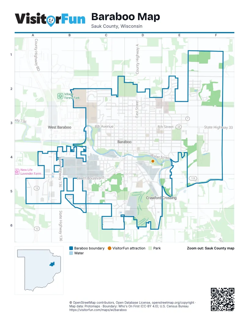
Street index of Baraboo
Each street on the sheet and the grid squares it crosses.
- County Highway TE1, E2, E3
- Bascom Hill DriveB2, C2
- Connie RoadB2
- Fox Hill RoadB2
- Iroquois CircleB2, C2
- Sequoia CircleB2, C2
- University Hill CourtB2
- Zajak DriveB2
- 15th AvenueC2, D2
- Algonquin DriveC2
- Amey DriveC2, C3
- Amundson DriveC2, C3
- Birch StreetC2, C3, C4
- Crawford StreetC2, C3
- Draper StreetC2, C3
- Ernstmeyer DriveC2, C3
- Iroquois CourtC2
- Madison AvenueC2, D2
- Monroe AvenueC2
- Monroe StreetC2, D2
- Naragansett AvenueC2
- 14th StreetD2, D3, E3
- 15th StreetD2, E2, F2
- 16th StreetD2, E2
- Ash StreetD2, D3, D4
- County Highway AD2
- East StreetD2, D3, D4
- Elizabeth StreetD2, D3, D4
- Hillcrest DriveD2, D3
- Keith StreetD2, D3
- Madison StreetD2
- North Ridge LaneD2, D3
- Oak StreetD2, D3, D4
- Roblee RoadD2, D3
- Tuttle StreetD2, D3
- 18th StreetE2
- 19th StreetE2, F2
- 20th StreetE2, F2
- 21st StreetE2, F2
- City View RoadE2
- Jefferson StreetE2, E3, E4
- Landau LaneE2
- Man Mound RoadE2, F2
- Manassas CourtE2
- Manasses DriveE2
- Meadow View DriveE2
- Ott LaneE2
- Park View DriveE2
- Parkgate DriveE2
- Surrey LaneE2
- Tandom TrailE2
- Tillberry DriveE2, F2
- Berry Hill CourtF2
- Manassas DriveF2
- Pleasant View DriveF2
- Valley View DriveF2
- 2nd AvenueB3, B4, C4, D4
- 8th AvenueB3, C3, D3
- 9th AvenueB3, C3, D3
- Berkley BoulevardB3
- Island CourtB3, C3, C4
- Moore StreetB3, B4, B5
- 10th AvenueC3, D3
- 11th AvenueC3, D3
- 12th AvenueC3, D3
- 13th AvenueC3, D3
- 14th AvenueC3, D3
- 4th AvenueC3, C4, D4
- 5th AvenueC3, D3
- 6th AvenueC3, D3
- 7th AvenueC3, D3
- Angle StreetC3
- Aztec PlaceC3
- Carignan CourtC3
- Center StreetC3, C4
- Park StreetC3, C4
- Ridge StreetC3, C4
- South Broadway StreetC3, C4
- Summit StreetC3, C4
- West StreetC3, C4
- Winnebago CircleC3
- Wood StreetC3
- Zoo LaneC3
- 10th StreetD3, E3
- 11th StreetD3, E3
- 12th StreetD3, E3
- 13th StreetD3
- 5th StreetD3, E3
- 6th StreetD3, E3
- 7th StreetD3, E3
- 8th StreetD3, E3
- 9th StreetD3, E3
- Albert RoadD3
- Barker StreetD3, D4
- Camp StreetD3, D4
- Martiny CourtD3
- Remington StreetD3, D4
- Warren StreetD3
- Wheeler StreetD3
- Greenfield StreetE3, F3
- Lincoln AvenueE3, E4
- State Highway 33E3, F3
- Washington AvenueE3, E4
- Adams CourtF3
- Eisenhower StreetF3, F4
- Kennedy StreetF3
- Roosevelt StreetF3, F4
- Carpenter StreetB4
- Commerce AvenueB4, A5, B5
- Deppe StreetB4, C4
- Hatchery RoadB4
- Industrial CourtB4, B5
- Krista CourtB4
- Lisa CourtB4
- Lynn AvenueB4, C4
- Sauk AvenueB4, C4
- State Highway 136B4, B5
- Victoria CircleB4
- 1st AvenueC4, D4
- 3rd AvenueC4, D4
- Andro StreetC4
- Badger DriveC4
- Blake StreetC4, D4
- Case StreetC4
- Ellis AvenueC4, C5
- Highland DriveC4, C5
- Hitchcock StreetC4, C5
- Lynn StreetC4, D4
- Maple StreetC4, D4
- Pine StreetC4
- Prairie AvenueC4
- Quarry StreetC4, C5
- Rachael RoadC4
- Russell StreetC4
- South BoulevardC4, B5, C5
- South ParkwayC4, D4, D5
- South StreetC4, D4
- Sycamore StreetC4
- Water StreetC4, D4, E4
- 1st StreetD4
- 2nd StreetD4, E4
- 3rd StreetD4, E4
- 4th StreetD4, E4
- Briar StreetD4
- Cherry LaneD4, D5
- Clark StreetD4
- Depot StreetD4
- Grove StreetD4, D5
- Hilltop CourtD4
- Lake StreetD4, D5, D6
- Litchfield LaneD4
- Martin StreetD4
- Mill Race DriveD4, E4, D5
- Mill StreetD4
- Mound StreetD4, E4
- Potter StreetD4
- Rivercrest DriveD4
- Rosaline StreetD4
- South Center StreetD4
- Victoria StreetD4
- Vine StreetD4, D5
- Walnut StreetD4, D5, C6, D6
- College AvenueE4
- Council StreetE4
- Crestview DriveE4
- Effinger RoadE4, E5
- Glenview DriveE4
- Remington CourtE4
- Conservancy CourtF4
- Conservation CourtF4
- Preservation StreetF4
- Commerce ParkwayA5
- County Highway WA5
- Gateway DriveA5
- Mine RoadA5, B5, C6, D6
- South Boulevard WestA5, B5
- Spencer CourtA5
- Teel CourtA5
- Lange CourtB5
- Canepa StreetC5
- Hagar RoadC5
- Hollywood StreetC5, D5
- Louis LaneC5
- Oak Park PlaceC5
- Parkside AvenueC5
- Pate StreetC5
- Silver CircleC5, D5
- Silver CourtC5
- Silver DriveC5, C6
- Spruce CourtC5
- Spruce DriveC5, C6
- Valley Glen CourtC5
- Waldo StreetC5
- Elm StreetD5
- Guppy StreetD5
- Hill StreetD5, E5
- Inverness Terrace CourtD5
- Manchester StreetD5, E5
- Matts Ferry RoadD5, E5
- Maxwell StreetD5
- Mulberry StreetD5
- Spring Creek CircleD5
- Springbrook DriveD5, D6
- Sumac CourtD5
- Withington StreetD5
- Kessler RoadE5
- Old Lake RoadE5, E6
- State Highway 113E5, F5
- County Highway DLC6
- Evergreen DriveC6
- Red Spruce AvenueC6
- White Spruce AvenueC6
- Gall RoadD6
Things to do on the Baraboo map
Places on the map
- Al Behrman Elementary School
- Al Ringling Theater
- Anytime Fitness
- Attridge Park
- Bachrodt Baraboo Motors
- Baraboo Civic Center
- Baraboo Country Club
- Baraboo Dog Park
- Baraboo Fresh Market
- Baraboo Kiwanis Riverwalk Park
- Baraboo Music
- Baraboo National Bank
- Baraboo Public Library
- Baraboo Senior High School
- Beyond Blessed Pantry
- Blain's Farm & Fleet
- BP Shop
- Broadway Diner
- Campbell Park
- Chief Naaga Kermani Park and Conservancy
- Circus World Museum
- City of Baraboo Municipal Building
- City View Park
- Coffee Bean Connection
- Deppe Park
- Dollar Tree
- DQ Grill & Chill
- East Elementary School
- Jack Young Middle School
- Mary Rountree Evans Park
- Menards
- Ochsner Park
- Pierce Park
- Saint Clare Hospital
- Saint Josephs Cemetery
- Sauk County Fairgrounds
- Statz Park
- Steinhorst Park
- Walmart Supercenter
- Walnut Hill Cemetery
Next to Baraboo
- West Baraboo
© OpenStreetMap contributors, Open Database License, openstreetmap.org/copyright · Map data: Protomaps · Boundary: Who's On First (CC-BY 4.0); U.S. Census Bureau















