

West Virginia map
Martinsburg map
About 19,047 people live here (Census Bureau, 2024 estimate). The sheet's index lists 300 streets; Delmar Orchard Road, West King Street and North Raleigh Street cross the most grid squares. Things to do inside the boundary: Queen Street Gallery and West Virginia Glass Outlet.
Open the map (PDF, US Letter)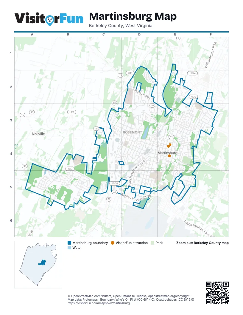
Street index of Martinsburg
Each street on the sheet and the grid squares it crosses.
- West King StreetC3, D3, D4, E4
- North Queen StreetE3, E4
- Winchester AvenueD4, D5
- South Queen StreetE4, E5
- Apple Harvest DriveC5, D5, B6
- East Moler AvenueE3, F3
- Edwin Miller BoulevardE2
- Williamsport PikeE2
- North Raleigh StreetE2, E3, D4, E4
- South Raleigh StreetD4, D5
- Tavern RoadD2, E3
- West Moler AvenueE3
- Dry Run RoadD2
- Klee DriveA5, B5
- Delmar Orchard RoadC3, B4, C4, B5, B6
- Foxcroft AvenueC3, C4, C5
- North Tennessee AvenueD2, D3, D4
- West Race StreetC3, D3, D4, E4
- Foxcroft CircleC4, D4, C5, D5
- New York AvenueD4, D5, D6
- Wilson StreetD5, E5
- Old Mill RoadC3, D3
- Mall DriveC4, D4
- East Burke StreetE4
- Rock Cliff DriveD2, D3
- South Tennessee AvenueD4
- Baltimore StreetD3, E3
- Randolph StreetD3, E3
- Snapp StreetC4, D4
- Tuscarora PikeC3
- Eagle School RoadE2
- Golf Course RoadE4
- North Tennessee Avenue - South Tennessee AvenueD4
- Exit SLS 45/5 NBE3
- West Martin StreetC3, D3, D4, E4
- West Stephen StreetC4, D4, E4
- Rubens CircleB4, B5, C5
- North High StreetE3, F3, E4
- West John StreetD4, E4
- Virginia AvenueD4, D5
- West Virginia AvenueD4, D5
- West Burke StreetD4, E4
- Woodbury AvenueE3, F3
- Prentiss Point ParkwayE5
- 3rd StreetE3, F3
- South Maple AvenueE4, D5
- East John StreetE4
- North StreetC3, D3
- Central AvenueF3, F4
- West South StreetD4, E4
- Bowers StreetD5
- Marketplace BoulevardC5
- Artisan WayD2
- Faulkner AvenueD4, D5
- Porter AvenueD4
- South Georgia AvenueD4
- South Louisiana AvenueD3, C4, D4
- Jefferson StreetD5
- Berry StreetD4, D5
- South Alabama AvenueD3, D4
- South Spring StreetE4
- West Addition StreetD4
- North Maple AvenueE3, E4
- East Stephen StreetE4, E5
- Boyd AvenueE3, E4
- Martins Landing CircleD2
- Old Courthouse SquareE2
- Fairfax StreetE5
- Hillcrest DriveD2, D3
- South Rosemont AvenueD4
- Union AvenueE3, F3
- Lincoln DriveD3
- Liberty StreetE3, E4
- South Church StreetD4, E4, D5
- South Kentucky AvenueD4
- South Illinois AvenueD4
- Fonlana CircleB5
- Gainsboro DriveB5
- Adam's DriveE2
- Enterprise CircleC5
- North Centre StreetE3, E4
- North Red Hill RoadC3, D3
- Fountain Head LaneD5
- Pennsylvania AvenueE3
- Silver LaneD4, D5
- Memorial Park AvenueC3, D3
- Honeysuckle DriveD2, D3
- Mill Race DriveD3
- Albert StreetE3, E4
- Thompson StreetD5
- Pierce Arrow WayE5
- Vicky Bullett StreetE4
- Buxton StreetD4, D5
- Gloucester DriveD2
- Adams StreetE3
- Gemstone DriveC4
- Athletic StreetF3
- Greenbriar RoadD3, E3
- Auburn StreetD3, E3, D4
- South College StreetE4
- Pendleton DriveD2, D3
- Jerry CourtD2
- Hood CircleC4
- State CircleE5
- Lemir DriveF3
- East RoadE2, F2
- Ledge DriveC3
- Strathmore Way WestA5, B5
- East King StreetE4
- Maryland AvenueD4, D5
- Germantown WayA5, B5
- Sycamore LaneD3
- Edgemont TerraceD3
- North Georgia AvenueD3, D4
- Bulldog BoulevardD5, E5
- Gussie AvenueE4
- Alonzo DriveC5, D5
- Beth StreetE4
- South Water StreetE4
- North Louisiana AvenueD3
- North Western AvenueF3
- North Delaware AvenueD3
- Osbourne WayD4, D5
- South Delaware AvenueD3, C4, D4
- Madison AvenueE3
- Viking WayC3
- Hillsdale PlaceA5
- Husky TrlA5
- Aero StreetE5
- East Race StreetE4
- Jasmine LaneD5
- Cashlin DriveB4, B5
- Henry StreetD4, E4
- Twigg DriveF3
- Meadowbrook DriveD3, E3
- Western AvenueF3
- Chagall LaneB5, C5
- Vast StreetE3
- Avery StreetE4
- Rothwell AvenueE3
- North Rosemont AvenueD3, D4
- Weis AvenueC5
- Station Terrace WestA5, B5
- Jensen WayE5
- Flemming AlleyD4
- Strine AvenueE3
- Texas StreetD5
- Raphael CourtB5
- Kyle DriveE5
- Grazier StreetE3
- Oak StreetE4
- Hess AvenueE3
- Lovelace WayD3
- Medical CourtD2, D3
- Courthouse DriveE2
- Eclipse CourtE2, E3
- Husky TrailA5
- Sentry LaneD2
- John Street EastE4, E5
- Wall StreetD4
- Homer CourtA5
- Legado DriveC3, C4
- Seurat LaneB5
- Lutz AvenueE1, E2
- Kauffman AvenueF3
- Bertelli CourtB5
- Morgan StreetD4
- Trader's WayD2
- Duke RoadF2, F3
- North Tuskegee DriveD4
- Williamsport AvenueE3
- Lakeview DriveD3
- Carrie WayD3
- Ellis StreetF3
- Darden Court WestB5
- 2nd StreetE3
- North Church StreetE4
- Bumblebee LaneF3
- Seibert StreetE4
- North College StreetE4
- North Spring StreetE4
- Station Terrace EastB5
- Echo StreetF2
- Florida AvenueD5
- Karla CourtF3
- Celaddon CourtB5
- Dim StreetE3
- Marquette DriveE5
- Legion StreetF3
- South High StreetE4
- Sheridan AvenueD5
- Darden Court EastB5
- Slick TerraceA5
- Berkely CircleE5
- Carroll StreetE4
- Gauguin DriveB5, C5
- Sycamore StreetE4, E5
- Orchard StreetE4, E5
- Checko CourtE5
- North Kentucky AvenueD3, D4
- Rosewood DriveD3
- Mulberry DriveD2, D3
- Daintree DriveB5
- Emmet Rousch DriveE5
- Apache DriveE4
- Bachman LaneE3, E4
- Circle DriveD4
- Half StreetF3
- Factory StreetE3
- Boston StreetD3, E3
- Diamond AvenueF3
- Overlook DriveD3
- Hooge StreetE3
- Terrace StreetE3
- North 3rd StreetE3, E4
- Walnut StreetE4, E5
- Teneno StreetE4
- Miami PlaceA5
- Cumberland Valley PlaceD4
- Spruce StreetE4, E5
- Alfalfa LaneA5
- Marshall AvenueE4
- Picasso CourtB5, C5
- Lewisburg LaneB5
- Strathmore Way EastB5
- Abino Hills Way WestB5
- Myna CourtF2
- Eastern AvenueF3
- Five Point AvenueE3
- Yoakum AvenueF3
- East Martin StreetE4
- Foundation WayD2
- Lambert StreetE3, F3
- Morrow AvenueF3
- Byrd DriveD3
- Exchange PlaceE3, E4
- Care Bear DriveE5
- West Ryneal StreetE5
- Autumn Leaf DriveD2
- Washington AvenueD5
- Professional CourtD3
- Washingnton MewsE2
- Lilac LaneC4
- May Apple LaneA5
- Detroit SquareA5
- Kline StreetE4
- Soar DriveF2
- Whitacre AvenueF2
- Oflannery CourtB5
- Vicksburg CourtF3
- East Commerce StreetE4
- Loweland DriveC4, D4
- Harris WayD2
- Pillar StreetC4, D4
- Botecelli CourtB5
- Linden LaneD4
- East Ryneal StreetE5
- Boston Tea StreetF2
- Norwalk AvenueD4
- Elizabeth StreetE3
- Equinox Way WestE5
- O'Keefe DriveB5
- Frederick StreetE3
- Primrose DriveF2
- Chestnut StreetE4
- North Elijah StreetD4
- School DrivewayE5
- Fargo LaneA5
- Tarkay PlaceB5
- Dailey StreetE3
- South Elijah StreetD4
- Jonquil LaneC4
- Waverly CourtC3
- Kilmer CourtC3
- White AvenueE4
- Swartz StreetE4
- Bluestone CourtC3
- Lupton DriveD3
- South Red Hill RoadC3
- South Vista LaneC3
- North Alabama AvenueD3
- Dali CourtB5
- South Valley StreetD4
- Vintage CourtE5
- Georgetown SquareD4
- Raven BoulevardF2
- Yorktown StreetF2
- Allen StreetE4
- Danbury RoadD6
- Tanner LaneD2
- Jackson PlaceD5
- Ramer CourtD4
- Light StreetE4
- Monocacy StreetF3
- Pardalote CourtF2
- Squaw TerraceB5
- Grant PlaceD3
- Commercial BoulevardC4
- Surrey CourtD3
- Carolina AvenueD4
Things to do on the Martinsburg map
Places on the map
- 7-Eleven
- Abell-Kilbourn House
- Advance Auto Parts
- All About Fabric
- Ambrose Park
- Anthony's Pizza
- Apollo Theatre
- Apple Valley Collision
- Apple Valley Toyota
- Applebee's
- Arts Center
- AutoZone
- Baltimore and Ohio Railroad Martinsburg Shops
- Baskin-Robbins/Dunkin' Donuts
- Bear's Repair & Tire Services
- Belle Boyd House
- Berkeley County Sheriff's Department
- Berkeley Medical Center
- Berkeley Senior Services
- Boom Town Historic District
- Boyd Avenue Historic District
- Boydville Historic District
- Briarwood Professional Park
- Charlotte Prather Park
- East Martinsburg Historic District
- Foxcroft Towne Center in Martinsburg
- Hood Circle
- Lake Thomas
- Lambert Park
- Lowe's
- Oatesdale Park
- P.O. Faulkner Park
- Rosemont Elementary School
- South Water Street Historic District
- United States Post Office
- Walmart Supercenter
- War Memorial Park
- West Martinsburg Historic District
- Westview Baptist Church
Next to Martinsburg
- Nollville
© OpenStreetMap contributors, Open Database License, openstreetmap.org/copyright · Map data: Protomaps · Boundary: Who's On First (CC-BY 4.0); Quattroshapes (CC BY 2.0)















