

Wyoming map
Cheyenne map
About 65,704 people live here (Census Bureau, 2024 estimate). The sheet's index lists 300 streets; Purple Heart Trail, East Pershing Boulevard and East Lincolnway cross the most grid squares. Things to do inside the boundary: Cheyenne Frontier Days Old West Museum, Cowgirls of the West Museum and Wyoming State Capitol.
Open the map (PDF, US Letter)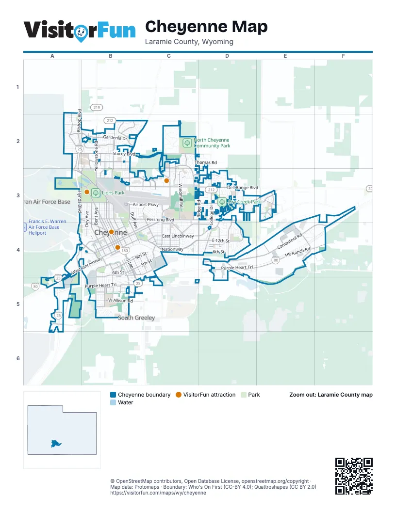
Street index of Cheyenne
Each street on the sheet and the grid squares it crosses.
- Purple Heart TrailD4, E4, F4, A5, B5, C5
- Dwight D. Eisenhower HighwayA5
- Central AvenueA3, B3, B4, B5
- East Pershing BoulevardB3, C3, D3, E3, F3
- Dell Range BoulevardB3, C3, D3
- East LincolnwayD3, E3, B4, C4, D4
- West LincolnwayA4, B4, A5
- North College DriveD3, D4
- I-180B4, B5
- Warren AvenueB3, B4
- Yellowstone RoadB2, B3
- East Four Mile RoadB2, C2
- Vandehei AvenueA2, B2
- West College DriveA5, B5
- West 8th AvenueA3, B3
- West Pershing BoulevardA3, B3
- US Highway 30E3
- North Greeley HighwayB4, B5
- Campstool RoadC4, D4, E4
- NationwayC4, D4
- Converse AvenueC2, C3, C4
- Storey BoulevardB2, C2
- Carey AvenueB3, B4
- Ridge RoadD2, D3, D4
- Powderhouse RoadB2, C2, B3
- East 12th StreetC4, D4
- Morrie AvenueB3, B4, C4, C5
- East 19th StreetC3, B4, C4
- Pioneer AvenueB3, B4
- Dey AvenueB3, B4, B5
- Missile DriveB4
- Whitney RoadE3, E4
- Walterscheid BoulevardB4, B5
- Logan AvenueC3, C4
- East 20th StreetB4, C4
- West 19th StreetB4
- Deming DriveB4
- Ames AvenueB4, B5
- Randall AvenueA3, B3, B4
- South Parsley BoulevardB5
- Parsley BoulevardB4, B5
- East 5th StreetB4, C4
- West 20th StreetB4
- East Fox Farm RoadC5
- Christensen RoadE4
- Campstool WayD4
- Avenue CC5
- HR Ranch RoadD4, E4, F4
- Hynds BoulevardA2, B2, A3, A4
- Snyder AvenueB3, B4, B5
- Bishop BoulevardA2, A3
- Evans AvenueB3, B4, C4
- Capitol AvenueB3, B4
- Windmill RoadC3, C4
- Cleveland AvenueD3, D4
- East 10th StreetB4, C4, D4
- Seymour AvenueB3, B4, C4
- Prairie AvenueB3, C3
- Gardenia DriveB2
- East 9th StreetB4, C4, D4
- West Jefferson RoadB5, C5
- O Neil AvenueB3, B4
- West 5th StreetB4, A5, B5
- Rawlins StreetC3, D3
- Evers AvenueA1, A2
- Henderson DriveC3, C4
- Taft AvenueD3, D4
- Airport Parkway WestB3
- West Allison RoadB5
- East Carlson StreetB2, C3
- Van Buren AvenueD3
- Airport ParkwayB3, C3
- Weaver RoadB2, B3
- West 24th StreetB4
- Southwest DriveA4, A5
- Venture DriveE4, F4
- Hayes AvenueD3
- Western Hills BoulevardA2, B2
- West Leisher RoadB5
- Sheridan StreetC3, D3
- Westland RoadA4, B4
- West Fox Farm RoadB5
- Hot Springs AvenueC4
- Legacy ParkwayB2
- Commerce CircleE4
- South Industrial RoadD4
- Mountain RoadC2, C3
- Burlington Trail RoadD4
- Plainview RoadC2
- Melton StreetB2, B3, C3
- Sunset DriveB2, B3
- East 24th StreetB3, B4
- Rue TerreC3
- Montclair DriveB2
- Prairie Hills DriveB2
- Meadow DriveD3, D4
- Countryside AvenueE3
- Hilltop AvenueC2, C3
- Miracle ParkwayB2
- Willshire BoulevardB2
- Omaha RoadC4
- Carla DriveD3
- Point BluffC2, C3
- South Cribbon AvenueB5
- West 4th StreetB4, B5
- East 1st StreetB4, C4
- Townsend PlaceB2, B3
- Holmes StreetC4, D4
- West 9th StreetB4
- Saddle Ridge TrailE3
- Education DriveB2, B3
- Stanfield AvenueB4, B5
- Hitching Post LaneE3
- Frontier Mall DriveC3
- South Snyder AvenueB5
- Oakhurst DriveA2
- Kennedy RoadA3, B3
- Manewal DriveB3
- Polk AvenueD3
- West 15th StreetB4
- Concord RoadC3
- Blue Bluff RoadC2
- Wilderness TrailE3
- Clear Creek ParkwayA5, A6
- Chestnut DriveC4
- East 8th AvenueB3
- Livingston AvenueD4
- T-Bird DriveC3
- Jackson StreetC3, D3
- Pinto LaneB5
- Seminoe RoadB3
- Foster AvenueE3
- West Carlson StreetB2
- Airport Parkway EastC3
- Walker RoadB2, A3, B3
- Short RoadB3
- West Four Mile RoadA2
- West 1st StreetB4
- Bent AvenueB3, B4, B5
- East 8th StreetB4, C4, D4
- Reed AvenueB3, B4, B5
- Dillon AvenueB3, B4, B5
- House AvenueB3, B4
- Laramie StreetC3, D3, E3
- East 7th StreetB4, C4, D4
- Maxwell AvenueB3, B4, C4
- East 18th StreetB4, C4
- East 13th StreetC4, D4
- Charles StreetC3, D3
- Van Lennen AvenueB3, B4, C4
- East 17th StreetB4, C4, D4
- Thomes AvenueB3, B4
- East 6th StreetB4, C4, D4
- East 22nd StreetC3, B4, C4
- Cribbon AvenueB3, B4, B5
- Rock Springs StreetC3, D3
- East 21st StreetB4, C4
- East 15th StreetB4, C4
- Hutchins DriveE4, F4
- Russell AvenueB3, B4, C4
- East 16th StreetB4, C4, D4
- McComb AvenueB3, B4, B5
- Alexander AvenueB3, B4, C4
- McCann AvenueD3, D4
- East 11th StreetC4, D4
- Dunn AvenueB3, B4, C4
- Monroe AvenueD3, D4
- Pebrican AvenueB4, C4
- Wills RoadD3, D4
- Thomas RoadC2, D2
- Bradley AvenueB3, B4, C4
- Canyon RoadC2
- West 18th StreetB4
- Duff AvenueB3, B4, C4
- Cheyenne StreetC3, D3
- East 23rd StreetC3, B4
- West 27th StreetB4
- Sagebrush AvenueC2, C3
- Crook AvenueC4
- West 17th StreetB4
- Apache StreetB2, C3
- West 28th StreetB4
- West 6th AvenueA3, B3
- West 2nd AvenueB3
- Sycamore RoadB2, B3
- Carbon AvenueC3, C4
- Atlantic DriveD4
- Campbell AvenueC4
- Sullivan StreetD3
- East 14th StreetC4, D4
- Fremont AvenueC4
- Madison AvenueD4
- Hugur AvenueC3, C4
- Marshall RoadB2, B3
- West 22nd StreetB4
- Buckskin TrailC2
- Pierce AvenueD3
- Syracuse RoadB2, B3
- Newton DriveB3, C3
- West 31st StreetB3, B4
- West 3rd StreetB5
- Gettysburg DriveD4
- Everton DriveD3
- West 6th StreetB4
- New Bedford DriveB2
- Forest DriveC3, C4
- Rollins AvenueC3, C4
- West 29th StreetB3, B4
- Hawthorne DriveA1, A2
- Deming BoulevardC3, C4
- Foothills RoadC2
- West 30th StreetB3, B4
- Pacific AvenueB4, B5
- Grove DriveC3, C4
- Moran AvenueC3
- West 26th StreetB4
- VA Loop RoadC3
- Trucker TrailE4, F4
- Kennedy DriveD4
- West 23rd StreetB4
- Big Sky TrailC2
- Bevans StreetC3, D3
- Tranquility RoadB2, C2
- Andover DriveB3, C3
- Green River StreetC3, D3
- Campfire TrailE3
- King Arthur WayC3
- West 21st StreetB4
- Ranger DriveA2
- East 25th StreetB3, B4
- Shoshoni StreetB2
- Kelley DriveC3, C4
- Custer StreetA2, B2
- Stinson AvenueB4, B5
- Osage AvenueB2
- Alyssa WayB2, C2
- Adams AvenueD4
- Cheshire DriveC3
- Olive DriveC4
- Ames CourtB3, B4
- South Lions Park DriveB3
- Hoy RoadB3
- Wildhorse TrailC2
- Greybull AvenueC3
- Panorama DriveD3
- Marie LaneB2
- Ahrens AvenueB5
- Ontario AvenueD3
- West 25th StreetB4
- Sterling DriveA1, A2
- Pattison AvenueC3
- Creighton StreetA2
- Stillwater AvenueB3, C3
- Oxford DriveB3, C3
- Arp AvenueB4, B5
- Pineridge AvenueC3
- West 10th StreetB4
- Ridgeland StreetA2
- Phoenix DriveD4
- Manhattan LaneB2
- Bomar DriveB2
- Albany AvenueC3, C4
- Gregg WayC3, D3
- Dover RoadC3
- Rio Verde StreetD3
- Spirit LaneB2
- Moore AvenueB3
- Brittany DriveA2
- West 7th StreetB4
- Baldwin DriveD4
- Cottonwood DriveD4
- Douglas StreetC3, D3
- West Prosser RoadB5
- West 1st AvenueB3
- Old Happy Jack RoadA4, B4
- East 4th StreetB4, C4
- Echostar DriveE4
- Frontage RoadC4
- Dorothy LaneB2, C2
- Maple WayC3
- Sweetwater TrailC2
- Continental PlaceD4
- Etchepare CircleA5
- Wind River TrailC2
- East 2nd AvenueB3
- Foxcroft RoadC3
- Hickory PlaceC3
- East 3rd AvenueB3
- Concerto LaneB5
- Spruce DriveC4
- Desmet DriveB5
- Crow RoadB2
- East 5th AvenueB3
- Sonata LaneB5
- Victoria DriveC3, D3
- CattleA3, B3
- Frontier StreetC4, D4
- Platte AvenueC4
- Talbot CourtA4, B4
- West 5th AvenueB3
Things to do on the Cheyenne map
Places on the map
- Absarraca Park
- Airport Golf Club
- Airport Parkway Park
- Anderson Elementary School
- Beth El Cemetery
- Brimmer Park
- Cahill Park
- Capital Lumber of Cheyenne
- Carey Junior High School
- Centennial Park
- Central High School
- Cheyenne Country Club
- Cheyenne Frontier Park
- Cheyenne Pack & Ship
- Cheyenne Regional Airport
- Cheyenne Veterans Affairs Medical Center
- Cheyenne Youth Baseball Dutcher Field
- Clear Creek Park
- College Park
- Dell Range Marketplace
- Dildine Elementary School
- Dry Creek Park
- East High School
- Frontier Mall
- Frontier Park
- Frontier Square
- Holliday Park
- Kiwanis Lake
- KOA Kampground
- Lake Absarraca
- Lions Park
- Little America Golf Course
- Little League Baseball fields
- Neighborhood Park
- North Cheyenne Community Park
- Prairie View Golf Course
- Red Wave Loop
- Sloans Lake
- South High School
- Wyoming Air National Guard
Next to Cheyenne
- Fox Farm–College
- South Greeley
- Warren Air Force Base
© OpenStreetMap contributors, Open Database License, openstreetmap.org/copyright · Map data: Protomaps · Boundary: Who's On First (CC-BY 4.0); Quattroshapes (CC BY 2.0)