

Wyoming map
Teton County map
About 23,272 people live here (Census Bureau, 2024 estimate). The sheet's index lists 300 streets; Grand Loop Road, North Highway 89 and North Park Road cross the most grid squares. Things to do inside the boundary: Grand Prismatic Spring, Grand Teton National Park and Jackson Hole Mountain Resort.
Open the map (PDF, US Letter)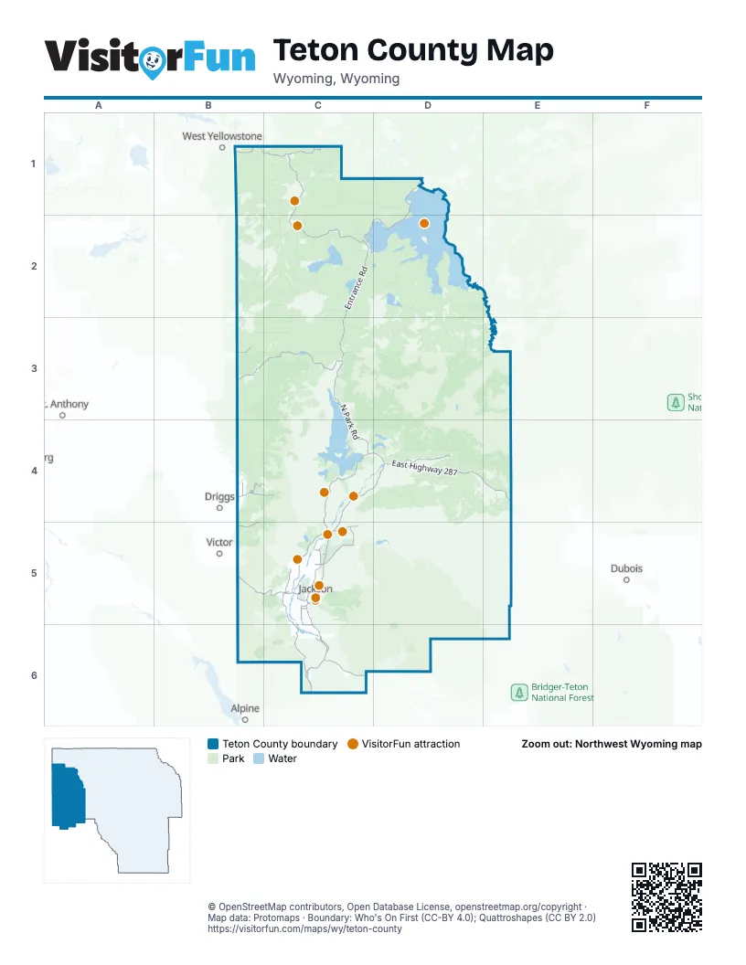
Street index of Teton County
Each street on the sheet and the grid squares it crosses.
- North Highway 89C4, D4, C5
- East Highway 287D4, E4
- North Park RoadC3, C4, D4
- South Highway 89C5, C6
- West Highway 22B5, C5
- South US Highway 191C6
- John D. Rockefeller Jr. Memorial ParkwayC3
- West Broadway AvenueC5
- North Cache StreetC5
- North Millward StreetC5
- Mercill AvenueC5
- Grand Loop RoadC1, D1, C2, D2
- South Entrance RoadC2, C3
- Teton Park RoadC4, C5
- North Moose-Wilson RoadC5
- West Entrance RoadB1, C1
- East Alta Ski Hill RoadB4
- West Alta Ski Hill RoadB4
- East Broadway AvenueC5
- East Airport RoadC5
- South Cache DriveC5
- East Entrance RoadD1
- West Pearl AvenueC5
- Grassy Lake RoadB3, C3
- South Fall Creek RoadC5, C6
- North Spring Gulch RoadC5
- Buffalo Valley RoadD4
- Lower Gros Ventre RoadC5
- Antelope Flats RoadC5
- South Park Loop RoadC5, C6
- Teton Canyon RoadB4, C4
- North Fish Creek RoadC5
- South Stateline RoadB4, B5
- Darby Canyon RoadB5
- South Henry's RoadC6
- Cave Falls RoadB3
- Old Faithful RoadC2
- Alta North RoadB4
- North Stateline RoadB4
- East Sagebrush DriveC5
- North Fall Creek RoadC5
- Solitude DriveC5
- East Evans RoadC6
- West Snow King AvenueC5
- High School RoadC5
- East Kelly AvenueC5
- West H-H-R Ranch RoadC5
- East Pearl AvenueC5
- Grant Village RoadC2
- South Millward StreetC5
- Flat Creek DriveC5
- Redmond StreetC5
- Maple WayC5
- West Main StreetC5
- South Willow StreetC5
- North Teton Village RoadC5
- East Gill AvenueC5
- West Apres Vous RoadC5
- East Swinging Bridge RoadC6
- Scott LaneC5
- Grant Campground RoadC2
- North West StreetC5
- East Snow King AvenueC5
- Buffalo WayC5
- Geyser AvenueC2
- East 3000 SouthB5
- East 2500 NorthB4
- North Willow StreetC5
- East 2000 SouthB4
- Spring Gulch RoadC5
- Bruun BoulevardC5
- East 6000 NorthB4
- Gros Ventre RoadC5, D5
- Flagstaff-Spread Creek RoadD4
- Mosquito Creek RoadB5, C5
- National Forest Development Road 264B3
- Hatchet-Lily Lake RoadD4
- Usfs 30100D4
- Shadow Mountain RoadC4
- Usfs 30290D4
- Breakneck Flat-Cottonwood Creek RoadD5
- Union Pass RoadE5, E6
- Gunsight Pass RoadD5
- Pacific Creek RoadD4
- North Fork Fall Creek R* RoadC6
- River Bend RoadC6
- Sheep Creek RoadC5
- Usfs 30340C4, D4
- Buffalo Meadows RoadE5
- Kinky Creek RoadD6, E6
- Signal Mountain RoadC4
- Rosie's Ridge RoadD4
- Flat Creek RoadC5, D5
- Ditch Creek RoadC4, C5
- Two Ocean Basin RoadE4
- National Elk Refuge RoadC5
- East Boundary RoadC4, C5
- Curtis Canyon RoadC5
- Fourmile Meadow RoadD4
- Lower Bar Bc RoadC5
- Old Togwotee HighwayD4
- Jenny Lake LoopC4
- Highlands Drive LoopC5
- Cottonwood Creek RoadC5, C6
- Pacific Creek-Wilderness Access RoadD4
- Snake River Levy SouthC5
- Dallas Lake RoadD5
- Firehole Lake DriveC1
- Red Rock Ranch RoadD5
- Spread Creek RoadD4
- Usfs 30120D4
- Saddle Butte DriveC5
- Pratt RoadC5
- Coyote Meadows RoadB3
- Pinochle RoadB4
- Mormon Row RoadC5
- Bailey Creek RoadC3, C4
- Wolff Ranch RoadD4
- South Squaw Creek RoadC6
- Snake River Ranch RoadC5
- South Pass TraverseC5
- FS 088B4
- Two Ocean Lake RoadD4
- North Leigh Canyon RoadB4
- Spalding Bay RoadC4
- Firehole Canyon DriveC1
- North Bar Y RoadC5
- Pilgrim Creek RoadC4
- Horse Creek RoadC6
- North Fork Fall Creek RoadC6
- Red Tail Butte RoadC5
- Lost Creek Ranch RoadC4
- South Park Feedgrounds RoadC6
- Colter Bay Dump RoadC4
- Gull Point DriveD1
- Hoback Junction South RoadC6
- Ryegrass RoadC5
- Porcupine Creek RoadC6
- Teton Pines DriveC5
- South Ely Springs RoadC5
- Dew Place RoadD5
- Taylor Ranch RoadD5
- Elk Track RoadD5
- Walton Ranch RoadC5
- Tucker Ranch RoadC5
- Perimeter DriveB4
- Bronco RoadC6
- Gros Ventre Campground RoadC5
- Aspen Meadow LaneB4
- 3 Creek DriveC5
- Granite Creek RoadC5
- South Leigh Canyon RoadB4
- Turpin Meadow LoopD4
- Paintbrush TrailC5
- Teton Valley Ranch RoadC5
- Bryan Flat RoadC6
- Lupine Meadows Park AccessC4
- East Butte RoadC5
- East Moulton Loop RoadC5
- West Johnny Counts RoadC6
- West Boyles Hill RoadC5
- West Big Trail DriveC5
- Park Creek Meadow RoadE5
- Trader RoadC5
- Cache Creek DriveC5
- Targhee Towne RoadB4
- Teton Wilderness DriveD4
- Lucas RoadC5
- Munger Mountain RoadC6
- Indian Springs DriveC5
- Reed DriveC5
- East McKean Du WayC6
- Soda Lake RoadD5
- Slate Creek RoadD5
- Crescent H RoadC5
- Lodgepole DriveC4
- Blair PlaceC5
- Antelope Springs RoadC4
- Grant Marina RoadC2, D2
- Lazy H RoadC5
- Yellow Rose DriveB4
- West Sagebrush DriveC5
- West Ridge RoadC5
- A.M.K. Ranch RoadC4
- South Creamery LaneC5
- West Zenith DriveC5
- Queen's LaneC5
- Riverside DriveB1
- Breakneck Flat RoadD5
- Pine Meadow RoadC5
- Elk Track Ranch RoadD5
- Huckleberry DriveC5
- Jensen Ranch RoadC6
- Range RoadC5
- Game Creek RoadC6
- Triangle X Ranch RoadC4
- Jensen Canyon RoadC5
- 4 Lazy F Ranch RoadC5
- Porter Loop RoadC5
- Cottonwood WayC4
- Arizona Lake RoadC4
- East Zenith DriveC5
- West Kaufman RoadB4
- Cattleman's Bridge RoadC4
- Lupine TrailC5
- Macleod Road at Granite CreekD6
- Rigby Road EastB4
- Riva Ridge RoadC5
- Lizard Creek CampgroundC3
- Ponderosa DriveC5
- North Snake River DriveC5
- Hungry Creek RoadB5
- Melody Creek LaneC5, C6
- Heck of A Hill RoadC5
- West Shoshone DriveC5
- Willowbrook LaneC5
- Poker Flats LoopC5
- Sleeping Indian DriveC5
- Grand View Point RoadC4
- Horse Creek Mesa RoadC6
- Buffalo RunD4
- Eagle Ranch RoadC6
- East Hansen AvenueC5
- East Simpson AvenueC5
- Usfs 30180D4
- East Deer Creek DriveC6
- Blair RoadB4
- Service RoadC1
- Meadow RoadC5
- Cottonwood Spur RoadC6
- Leeks Marina RoadC4
- North Lake Creek DriveC5
- Bridge Bay Campground RoadD1
- Bowman RoadC5
- Box Creek RoadD4
- Fountain Flat DriveC1
- Pine DriveC5
- West Eagle Crest DriveC5
- Wildhorse RoadC6
- McCollister DriveC5
- South Tensleep DriveC5
- Brooks Lake RoadE4
- Group LoopC4, C5
- Swan RoadC5
- Twin Creek Ranch RoadC5
- Melody Ranch DriveC5, C6
- North Prince PlaceC5
- Rangeview DriveC5
- Brush Creek RoadC4
- Highland TrailC6
- Corner Creek LaneC5
- South Park Ranch RoadC5
- Spring Creek Ranch RoadC5
- Mule Foot DriveC6
- Snow King DriveC5
- Thunder RoadC5
- Porcupine-Squaw Creek Plateau RoadC6
- North Avalanche Canyon RoadC5
- West Nethercott LaneC5
- East Trap Club RoadC5
- Horn's Hole TraverseC5
- North Wenzel LaneC5
- Spring Creek RoadB4
- Upper Cache Creek DriveC5
- Schwabacher RoadC4
- South Cortland DriveC6
- Wagon RoadC4
- Jenny Lake CampgroundC4
- Granite Loop RoadC5
- South Palmer Creek DriveC6
- Sylvia DriveC5
- East Oatgrass RoadC5
- Tribal Trail RoadC5
- Loop DC4, C5
- North Harvest Dance RoadC5
- Cody Creek DriveC5
- East Zenith RoadC5
- Altamont RoadB4
- South McKoy RoadC6
- Four Pines RoadC5
- Bechler Station RoadB3
- Usfs 30160D4
- Rodeo DriveC5
- Colter Bay Entrance RoadC4
- South Little Horsethief LaneC6
- Mallard RoadC5
- South Ricks RoadC6
- Beaver Creek RoadC5
- Spruce DriveC5
- Blue Crane DriveC5
- North Green LaneC5
- End Highlands RoadC4
- South Lake Creek DriveC5
- Goosewing RoadD5
- Mesa RoadC1
- Wilderness DriveC5
- White Grass Trailhead RoadC5
- Loop AC4, C5
- Balsam LaneC5, C6
- Laramie TraverseC5
Things to do on the Teton County map
Places on the map
- Alder Lake
- Alta
- Alta Census County Division
- Baseline Flat
- Beach Lake
- Beula Lake
- Bradley Lake
- Bridge Bay Campground
- Bridger Lake
- Burned Ridge
- Colter Bay Campground
- Coyote Meadows
- De Lacy Lakes
- Death Canyon Camping Zone
- Delusion Lake
- Elk Ranch Reservoir
- Emma Matilda Lake
- Enos Lake
- Grand Targhee Resort
- Grand Teton
- Grand Teton National Park
- Granite Basin Lakes
- Grant Village Campground
- Grassy Lake Reservoir
- Gros Ventre Campground
- Gros Ventre Wilderness
- Heart Lake
- Hering Lake
- Hoback
- Indian Lake
- Jackson
- Jackson Hole Airport
- Jackson Hole Mountain Resort
- Jedediah Smith Wilderness
- John D. Rockefeller, Jr. Memorial Parkway
- National Elk Refuge
- Palisades Wilderness Study Area
- Shoal Creek Wilderness Study Area
- Teton Wilderness
- Winegar Hole Wilderness
Next to Teton County
- Alpine
- Driggs
- Dubois
- St. Anthony
- Victor
- West Yellowstone
© OpenStreetMap contributors, Open Database License, openstreetmap.org/copyright · Map data: Protomaps · Boundary: Who's On First (CC-BY 4.0); Quattroshapes (CC BY 2.0)















