

Alabama road map
Alabama highway map
11 Interstate routes run about 1,111 miles in Alabama, each on a sheet of its own. The sheet's index lists 33 highways; I-65, I-59 and I-20 cross the most grid squares. Towns on it: Huntsville, Birmingham and Montgomery.
Open the map (PDF, US Letter)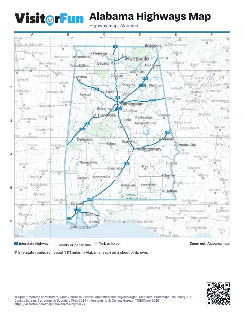
Road maps of Alabama
10 road maps: each Interstate and byway on a sheet of its own.
Highway index of Alabama
Each highway on the sheet and the grid squares it crosses.
- I-10B6, C6
- I-20B3, B4, C2, C3, D2, E2
- I-22B2, C2
- I-59B3, B4, C2, C3, D1, D2, E1
- I-65B5, B6, C1, C2, C3, C4, C5, D3, D4
- I-85D4, E3, E4
- I-165B6
- I-359C3
- I-459C3, D2
- I-565C1, D1
- I-759D2
- US 11C3
- US 29E3, E4
- US 31C1, C2, C3
- US 72C1, D1
- US 78B2, C2, D2
- US 80D4, E4
- US 82B3, C3, D4
- US 90B6
- US 98B6
- US 231D1
- US 280C2, C3, E4
- US 431D1, D2, E4
- AL 5C3
- AL 14D4
- AL 20C1
- AL 21D4
- AL 69C2, C3
- AL 108D4
- AL 152D4
- AL 255D1
- AL 759D2
- AL 959D2
Places on the map
- Abbeville
- Albertville
- Alexander City
- Andalusia
- Argo
- Auburn
- Bessemer
- Birmingham
- Bridgeport
- Calera
- Chelsea
- Clanton
- Cullman
- Daphne
- Decatur
- Demopolis
- Dothan
- Enterprise
- Eufaula
- Fayette
- Florence
- Foley
- Fort Payne
- Greenville
- Gulf Shores
- Hamilton
- Huntsville
- Jackson
- Jasper
- Monroeville
- Montgomery
- Oneonta
- Phenix City
- Piedmont
- Prattville
- Roanoke
- Russellville
- Saraland
- Selma
- Sylacauga
- Thomasville
- Troy
- Tuscaloosa
- Tuscumbia
© OpenStreetMap contributors, Open Database License, openstreetmap.org/copyright · Map data: Protomaps · Boundary: U.S. Census Bureau, Cartographic Boundary Files 2024 · Interstates: U.S. Census Bureau, TIGER/Line 2026