

Alabama map
Colbert County map
About 58,785 people live here (Census Bureau, 2024 estimate). The sheet's index lists 300 streets; East Lee Highway, Pine Street and East 2nd Street cross the most grid squares. Things to do inside the boundary: FAME Recording Studios, Ivy Green and Muscle Shoals Sound Studio.
Open the map (PDF, US Letter)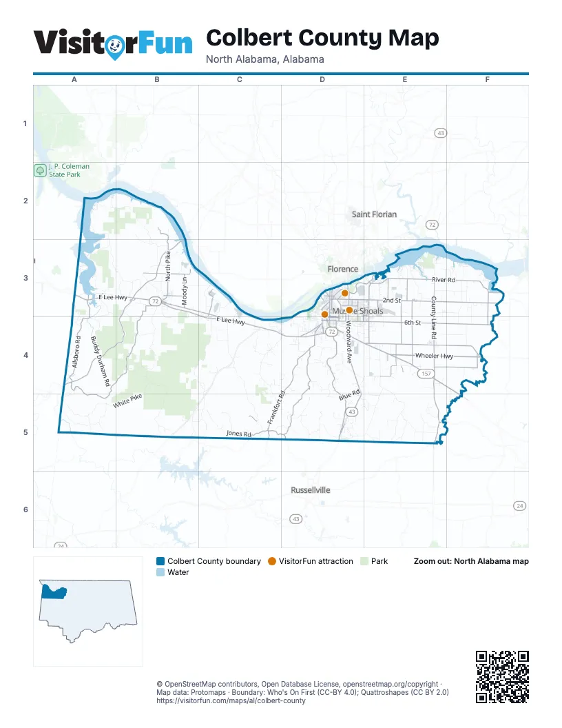
Street index of Colbert County
Each street on the sheet and the grid squares it crosses.
- Wheeler HighwayD4, E4, F4
- East Lee HighwayA3, B3, C3, C4, D4
- Natchez Trace ParkwayB3, A4, B4
- University of North Alabama HighwayE4, F4, F5
- Woodward AvenueD3, D4, D5
- Allsboro RoadA3, A4, B4
- Ricks LaneE4
- Wilson Dam HighwayD3, E3, E4
- George Wallace HighwayD5
- North Wilson Dam RoadE3
- South Wilson Dam HighwayE3, E4
- North Jackson HighwayD3
- Natchez Trace Access RoadB3, A4
- Leslie AvenueE4
- North Wilson Dam HighwayE3
- Margerum AnnexA3
- Joe Wheeler HighwayF4
- East 2nd StreetD3, E3, F3, D4
- Old Lee HighwayB3, C3, C4, D4
- 2nd StreetB3, D3, E3, E4
- West 6th StreetD3, D4, E4
- East 6th StreetD3, D4, E4
- Avalon AvenueD3, E3
- Hatch BoulevardD3
- Joe Wheeler DriveD4
- South Woodmont DriveD4
- Veterans BoulevardD4
- East 1st StreetD3, D4
- West Montgomery AvenueD3
- East Avalon AvenueD3
- South Hook StreetD4
- South Montgomery AvenueD3
- North Main StreetD3, D4
- North Montgomery AvenueD3
- North Hook StreetD3, D4
- North Cave StreetD3, D4
- South Cave StreetD4
- South Jackson HighwayD3
- South Dickson StreetD4
- East 25th StreetD3
- South Main StreetD4
- Cox Creek ParkwayE3
- McClain AvenueD3
- Frankfort RoadD4, C5, D5
- 6th StreetB3, E3, E4, F4
- Old Highway 20E4, F4
- River RoadE3, F3
- Underwood Mountain RoadD4, D5
- Country Line RoadE4, E5
- North PikeB2, B3
- Mount Hester RoadB3, B4
- Woodmont DriveD4, D5
- County Line RoadE3, E4, E5
- Maud RoadA4, A5
- Cross LaneB3
- Gnat Pond RoadE3, E4
- Marthaler LaneE3, E4
- Cottontown LaneE4, F4
- Moody LaneB3
- Alabama AvenueD3, E3, E4, D5
- Haley DriveC3
- Sockwell LaneE4
- Waterloo RoadC5, D5
- Mynot RoadA4, B4
- Ford RoadE3
- Tennessee River RoadE3
- County Road 61E3
- Mount Stanley RoadF3, F4
- Jackson HighwayD5
- Foster Mill RoadF3
- Harding AvenueD3
- Cox BoulevardD3
- North Commons Street EastD3
- Jackson AvenueD3, E3, D5
- Lile LaneF4
- Webster StreetE3
- Brown StreetB3, D3, D4
- South Atlanta AvenueD3
- Atlanta AvenueD3
- County Road 20B3, C4
- Broadway AvenueD3, E3, D4
- West Pasadena AvenueD3
- Crooked Oak RoadC5
- North King StreetD3, D4
- William F. Gardiner AvenueD4
- South Harding AvenueD3, D4
- Pasadena AvenueD3
- Jackson StreetD5
- West Clark Avenue / Broadway AvenueD3, D4
- East Commons Street SouthD4
- North Commons Street WestD3
- East Moore StreetD3
- West Moore StreetD3
- Wolf Springs RoadE5
- Gordon AvenueD3
- County Road 64F4
- North Dover AvenueD3
- South Broadway AvenueD4
- Old Jackson HighwayD5
- South Brown StreetD4
- King AvenueD4
- South King AvenueD4
- County Road 49C5
- Riverton Rose TrailA2, B2, A3, B3
- White PikeB3, B4, A5, B5
- Mount Mills RoadC3, B4, C4, C5
- Lagrange RoadE4, E5
- Coondog Cemetery RoadB4, B5
- Buddy Durham RoadA4
- Wagnon Mountain RoadC4, C5
- Jones RoadC5
- Trail 37A5
- Hawk Pride Mountain RoadC4, D4
- Sally Burns RoadA5
- Mulberry LaneB3, C3, C4
- Ligon Springs RoadD5
- County Road 33B5, C5
- Blue RoadD4, D5
- Stewart Camp RoadB4
- Hatton School RoadF3, F4
- Trail 36A5
- Red Rock RoadC4
- Colburn Mountain RoadD5, E5
- Bainbridge RoadE3
- Sutton Hill RoadA3, B3, B4
- Old Memphis PikeC4, D4
- Asphalt Rock RoadA3, A4
- Fossick LaneB3
- Mill Creek LoopB3
- Gilbert LaneB3
- Aycock Cemetery RoadE5
- Cook Creek RoadD5
- Gargis LaneE4
- Mt Pleasant RoadE3, F3
- Crockett LaneE4, F4
- State Line RoadA3, A4
- Hunter RoadE3
- Co Farm RoadD4
- Garner LaneC3, C4
- Smokey RoadB3
- 3 Mile LaneE4
- Poplar Creek LoopE5
- Patrick LaneC4
- Ables RoadA3, B3
- Spring Valley RoadD4, E4
- Old Chickasaw Boundary RoadC5
- Smallwood Mountain RoadC4
- Cove RoadB3, B4
- Cook LaneD4
- Waldrep LoopE5
- Milk Springs RoadD4
- Margerum RoadA3, B3
- Jarman LaneE3, F3
- Mangerum RoadA3, B3
- Industrial DriveB3, D4
- Pineywoods RoadE5
- Foster Nolen RoadD4
- Baker LaneD4
- Henderson Point RoadD4
- John R StreetD3, D4
- Shaw RoadF3, F4
- Wallace Mill RoadF3
- Fennell RoadF4
- Little Egypt RoadD5
- Osborn Hill RoadD5
- Pickwick StreetD3, D4
- Lime Kiln RoadB3, E3
- Greenhill RoadC5
- Coburn Mountain RoadE4, E5
- Henry RoadB5, C5
- Miller RoadA4, B4
- Srygley Church RoadB5
- Claunch LoopD5
- Santose RoadD5
- Loop RoadC4, C5
- Vandiver Hollow RoadD5, E5
- Rickard Cutoff RoadB4
- Buchanan Peninsula RoadA2, A3
- Lakeshore DriveE3, F3
- Fox Trap RoadE5
- Michigan AvenueD3
- Counts DriveE3, E4
- Beacon Light RoadB3
- Old Memphis RoadD4
- Lime Rock RoadD5
- Mingo RoadA4, A5
- 7th StreetB3, E3
- Elledge LaneD4
- New Bethel RoadC4, D4
- J McGee RoadE4
- Flatwoods RoadC4, D4
- Mill RoadB3
- Mount Mills Tower RoadC4
- Decatur StreetD4
- Wilson Lake Shores RoadE3
- East 3rd StreetD3, D4
- Grand AvenueD3, E4
- Sprout Spring RoadF3
- Park BoulevardD3
- East 5th StreetD3, D4
- River Bluff DriveD3
- Lane Spring RoadB2, B3
- Sherrod LaneC4
- Hawk Pride Homestead RoadC4
- Douglas RoadE5
- Ashe BoulevardD3
- Edison AvenueD3
- Puritan AvenueD3
- Bull Skull Hollow RoadE5
- Allen LaneC4
- Coburn Mill RoadD5
- Reid AvenueC4, D4
- King Bridge RoadF4
- Liberty RoadA4
- East 8th StreetD3, D4
- River DriveD4
- Pine StreetB3, D3, E3, C4, D4
- Tennessee River DriveE3
- Kiser LaneF4, F5
- Eason AvenueD3
- Eagle Point DriveA2
- Langrange College RoadE4
- Southern BoulevardD3, E3
- Ford AvenueD3
- Blackwell RoadD3, D4
- East 4th StreetD3, D4
- Waterford DriveE3
- Bus Barn RoadD4
- Gargis Hollow RoadF3
- Braden Lane RoadE4, E5
- Bainbridge CrossingE3
- East 11th StreetD3, D4
- Bald Knob RoadC4
- East 31st Street / East 10th AvenueD3
- Fawn Lake Bridge RoadC4
- Oak StreetB3, D4, E4, D5
- Allen LoopC4, D4
- East 7th StreetD3, D4
- Clement RoadE5
- Ore Mine RoadE4
- Spring Valley LaneA3, D4
- Cane Creek RoadC3
- Neil Morris RoadD4
- Duncan LaneE4
- Lynwood AvenueD5
- Dearborn AvenueD3
- Snowdown RoadA3
- Cedar LaneB3
- Aycock Bridge RoadE5
- Carter DriveC4
- Waverly AvenueD3
- Missouri StreetD4
- East 30th StreetD3
- Golden RoadC4
- Moontown RoadB3
- Broadway StreetD3, E3
- McCormack RoadE4
- Wheeler View LaneF3
- Shop PikeD3
- College StreetB3, D3, E4
- East 9th StreetD3, D4
- Midland AvenueD3
- County Road 59D4, E4
- Roosevelt AvenueD3, E3, E4
- Buzzard Roost RoadA3
- Church LoopC4
- Bigbee TrailD4
- Highland AvenueD3
- George Wallace BoulevardD3, D4
- Cherry LaneC4
- East 17th StreetD3
- Graham AvenueD4
- Firestone AvenueD3
- County Road 15B3
- Wittstore RoadE5
- Markate AvenueE3
- Reduction Plant RoadE3
- Brick School RoadE3
- Hereford LaneE4
- Old Natchez Trace RoadA4
- Spangler RoadE4
- Bainbridge LoopE3
- North Columbia AvenueD3
- New Cut RoadD4
- Keller Quarry RoadD4
- North Dickson StreetD3, D4
- East 19th StreetD3
- Edgewood DriveD3, D4
- Kirkland AvenueD5
- Little Bear Creek RoadD4
- North Head Hollow RoadF3
- Indian Springs RoadC5, D5
- Oak Hill AvenueD3, D4
- East 12th AvenueD3
- Lime Kiln Hollow DriveE3
- Veterans ShoresF3
- Quarry RoadD5
- Glendale AvenueD3
- Hollowfield RoadE5
- West 20th AvenueD3
Things to do on the Colbert County map
Places on the map
- Airport Complex
- Avalon Park
- Bald Knob
- Ball Knob
- Barton Cemetery
- Bell Quarter Hill
- Bickley Point
- Big River Airpark
- Braden Point
- Buckeye Hill
- Bugg Mill Hollow Loop
- Cane Creek Canyon Nature Preserve
- Cheatham Post Office
- Cherokee
- Cherokee High School
- Cherokee Quarry (#138)
- Coburn Mountain
- Colbert County High School
- Colbert Mountain
- Cypress Lakes Golf & Country Club
- Downtown Sheffield
- Freedom Hills Wildlife Management Area
- Helen Keller Hospital
- Ivy Green
- John W Gattman Park
- Leighton
- Littleville
- Muscle Shoals
- Nitrate Village No. 1 Historic District
- North Alabama Shoals Hospital
- Pride Quarry
- Riverton Community Hunting Area
- Robert Trent Jones Golf Trail at the Shoals
- Rogers Group North Alabama Quarry
- Rose Trail Park Campground
- Sheffield
- Spring Creek Golf Course
- Tuscumbia
- Tuscumbia Historic District
- Tuscumbia Quarry
Next to Colbert County
- Florence
- Russellville
- Saint Florian
© OpenStreetMap contributors, Open Database License, openstreetmap.org/copyright · Map data: Protomaps · Boundary: Who's On First (CC-BY 4.0); Quattroshapes (CC BY 2.0)