

Alabama map
North Alabama map
The sheet's index lists 33 highways; US 72, US 43 and AL 157 cross the most grid squares. Things to do inside the boundary: Buck's Pocket State Park, Burritt on the Mountain and Cathedral Caverns State Park. Also on it: Albertville, Anderson and Ardmore.
Open the map (PDF, US Letter)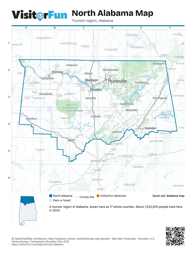
Highway index of North Alabama
Each highway on the sheet and the grid squares it crosses.
- I-22A4, B4, B5, C5
- I-59E3, E4, F2, F3
- I-65C2, C3, C4, C5
- I-565C3, D2
- I-759E4
- US 11E4
- US 31C2, C3, C4, C5
- US 43A3, A4, B2, B3, B4
- US 72A2, B2, C2, C3, D2, D3, E2, E3, F2
- US 78A4, B4, B5, C5
- US 231D2, D3, D4
- US 278A4, D4, E4, F4
- US 411E4, F4
- US 431D2, D3, E3, E4
- TN 7C2
- AL 9F4
- AL 13B2, B3
- AL 17A3, A4, B2, B3
- AL 20B2, C2, C3
- AL 24A3, B3, C3
- AL 53C2, D2
- AL 67C3
- AL 68F4
- AL 69C4
- AL 79D3, E3
- AL 118A4, B4
- AL 133B2
- AL 157B2, B3, C3, C4, D4
- AL 171A4, B4
- AL 255D2
- AL 279E2, E3
- AL 291E4
- AL 759E4
Things to do on the North Alabama map
- Buck's Pocket State Park
- Burritt on the Mountain
- Cathedral Caverns State Park
- Decatur Mall
- FAME Recording Studios
- Gadsden Mall
- Huntsville Botanical Garden
- Huntsville Museum of Art
- Ivy Green
- Joe Wheeler State Park
- Lake Guntersville State Park
- Little River Canyon National Preserve
- Monte Sano State Park
- Muscle Shoals Sound Studio
- North Alabama Railroad Museum
- Rickwood Caverns State Park
- Russell Cave National Monument
- U.S. Space & Rocket Center
- Unclaimed Baggage
Places on the map
- Albertville
- Anderson
- Ardmore
- Athens
- Bridgeport
- Cullman
- Decatur
- Florence
- Fort Payne
- Gadsden
- Guntersville
- Hamilton
- Hartselle
- Huntsville
- Jasper
- Madison
- Meridianville
- Oneonta
- Russellville
- Scottsboro
- Tuscumbia
Next to North Alabama
- Central Alabama map
- Northwest Georgia
- Mississippi Hills
- East Tennessee
- Middle Tennessee
- West Tennessee
© OpenStreetMap contributors, Open Database License, openstreetmap.org/copyright · Map data: Protomaps · Boundary: U.S. Census Bureau, Cartographic Boundary Files 2024