

Arkansas road map
Arkansas highway map
10 Interstate routes run about 736 miles in Arkansas, each on a sheet of its own. The sheet's index lists 38 highways; I-40, I-30 and I-49 cross the most grid squares. Towns on it: Little Rock, Fayetteville and Fort Smith.
Open the map (PDF, US Letter)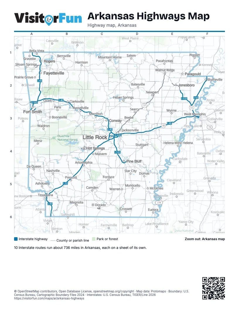
Road maps of Arkansas
11 road maps: each Interstate and byway on a sheet of its own.
Highway index of Arkansas
Each highway on the sheet and the grid squares it crosses.
- I-30A5, B4, B5, C3, C4
- I-40A2, A3, B2, B3, C3, D3, E3, F3
- I-42A1
- I-49A1, A2, A5, A6, B6
- I-55F2, F3
- I-57C3, D2, D3, E2
- I-430C3, C4
- I-440C3, C4
- I-530C4, D4
- I-540A3
- I-555E2, F3
- I-630C4
- US 49E2
- US 62A1, A2
- US 63C6, D3, D4, E2, E3
- US 64D3
- US 65C3, C4, D4
- US 65BD4
- US 67C3, C4, D2, D3
- US 70B4, C4
- US 70BB4, C4
- US 71A1, A2, A3
- US 71BA2
- US 78E2, F2, F3
- US 79D4
- US 82C6, E6
- US 167C3, C4, C6, D3
- US 270B4, C4
- US 271A3
- US 278E6
- US 412A1, E2
- AR 5C4
- AR 7C6
- AR 14E2
- AR 16A2
- AR 151A5
- AR 549A3
- AR 642A1
Places on the map
- Arkadelphia
- Ashdown
- Batesville
- Beebe
- Bella Vista
- Berryville
- Blytheville
- Booneville
- Camden
- Clarksville
- Conway
- Crossett
- De Queen
- Dumas
- El Dorado
- Eudora
- Fayetteville
- Fordyce
- Fort Smith
- Gravette
- Harrison
- Heber Springs
- Helena-West Helena
- Hot Springs
- Jacksonville
- Jonesboro
- Little Rock
- Magnolia
- Malvern
- McGehee
- Mena
- Monticello
- Morrilton
- Mountain Home
- Nashville
- Newport
- Ozark
- Paragould
- Paris
- Piggott
- Pine Bluff
- Pocahontas
- Prairie Grove
- Prescott
- Rogers
- Russellville
- Salem
- Searcy
- Siloam Springs
- Star City
- Stuttgart
- Texarkana
- Waldron
- Walnut Ridge
- Warren
- West Memphis
- Wynne
© OpenStreetMap contributors, Open Database License, openstreetmap.org/copyright · Map data: Protomaps · Boundary: U.S. Census Bureau, Cartographic Boundary Files 2024 · Interstates: U.S. Census Bureau, TIGER/Line 2026















