

Arkansas map
Fort Smith map
About 90,507 people live here (Census Bureau, 2024 estimate). The sheet's index lists 300 streets; Dallas Street, Rogers Avenue and Jenny Lind Road cross the most grid squares. Things to do inside the boundary: Fort Smith Museum of History, Fort Smith National Historic Site and Western Arkansas' Mountain Frontier.
Open the map (PDF, US Letter)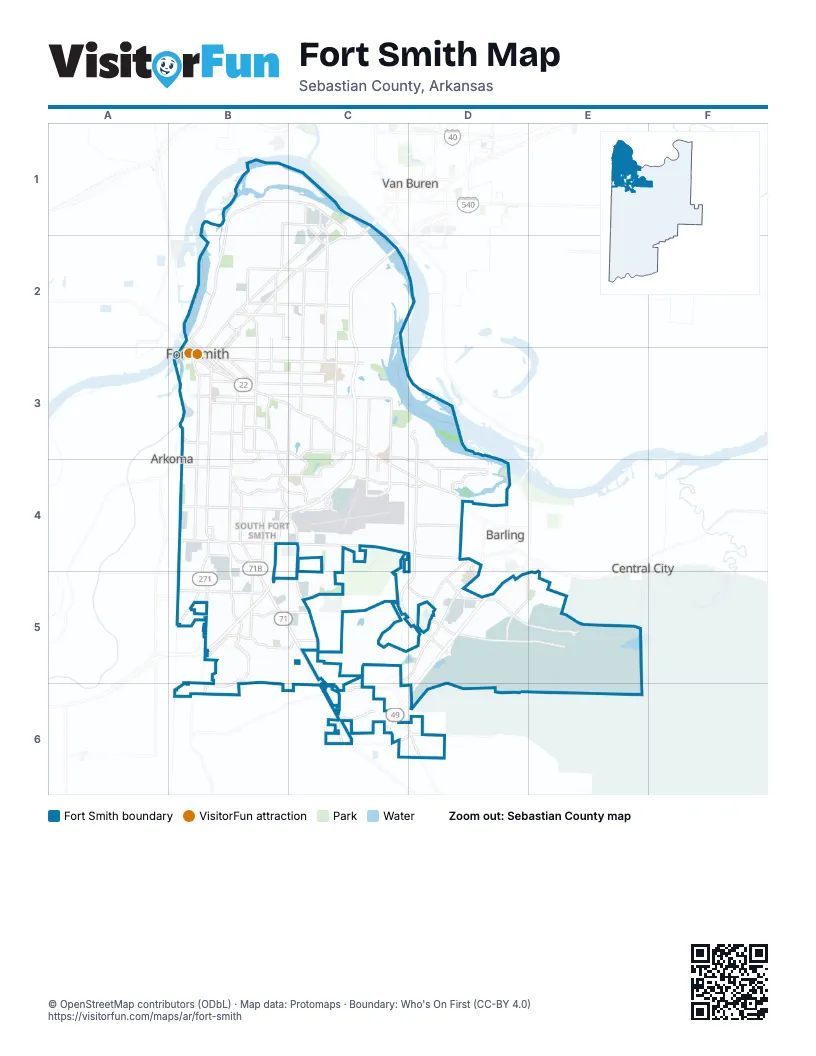
Street index of Fort Smith
Each street on the sheet and the grid squares it crosses.
- Rogers AvenueB3, C3, C4, D4
- Zero StreetB4, C4, D4
- Midland BoulevardC1, B2, C2
- Towson AvenueB3, B4
- US Highway 71 SouthB4, B5
- North 10th StreetB2, B3
- North 11th StreetB2, B3
- Garrison AvenueB3
- Jenny Lind RoadB3, B4, B5, B6
- Phoenix AvenueB4, C4, D4
- Grand AvenueB3, C3
- Old Greenwood RoadB3, B4, C4
- Wheeler AvenueB3, B4
- Kelley HighwayB2, C2
- South 31st StreetB3, B4, B5
- South 6th StreetB3, B4
- North Waldron RoadC2, C3
- South 5th StreetB3, B4
- South Y StreetB3, C3
- South Waldron StreetC3, B4, B5
- South Waldron RoadC3
- Burrough RoadC5
- Carnall AvenueB3
- Garland AvenueB3
- Frontier RoadD4
- Massard RoadD3, D4, C5, D5
- Riverfront DriveB1, C1, B2, C2
- Dallas StreetB3, C3, B4, C4, D4
- North 6th StreetC1, B2, C2, B3
- State Line RoadB3, B4, B5
- Chad Colley BoulevardD4, C5, D5, C6
- Roberts BoulevardD5, E5
- South 28th StreetB3, B4, B5
- Cliff DriveC3, B4, C4
- South 66th StreetC3, C4
- Custer BoulevardD5, E5
- North Albert Pike AvenueC2, C3
- Spradling AvenueB2, C2
- Free Ferry RoadB3, C3
- North 32nd StreetB1, B2, B3
- Park AvenueB3, C3
- South 24th StreetB3, B4, B5
- Kinkead AvenueB3, C3
- Brooken Hill DriveB5, C5
- Country Club AvenueB3, C3
- South 21st StreetB3, B4
- Gary StreetB4, C4, D4
- South 74th StreetC3, C4
- Cavanaugh RoadB5
- Taylor AvenueD5, E5
- North 50th StreetC2, C3
- Wells Lake RoadD4, D5
- McKennon BoulevardC4
- North O StreetB2, C2
- N Street NorthB2, C2
- North E StreetB2, B3
- North B StreetB2, B3
- South 23rd StreetB3, B4
- S Street SouthB3, C3
- Veterans AvenueD4, D5
- South I StreetB3
- Hendricks BoulevardB3, C3, B4
- North Greenwood AvenueB2, B3
- Dodson AvenueB3
- North 12th StreetB2, B3
- Steep Hill RoadC5, C6
- Houston StreetB4, D4
- Vicksburg StreetB4
- North 21st StreetB2, B3
- Leigh AvenueC4
- Texas RoadB5
- Fianna WayB5, B6
- Independence StreetB4
- South Greenwood AvenueB3
- Meandering WayD4
- North A StreetB2, B3
- South 70th StreetC3, C4
- South 14th StreetB3, B4
- North 5th StreetB2, B3
- Newlon RoadB1, C1, C2
- U Street SouthB3, C3
- South Fresno StreetB4, C4
- Rye Hill Road EastC6
- Division StreetB2
- Rye Hill Road SouthD6
- South D StreetB3
- Moody RoadD4
- Mussett RoadB1, B2
- North 23rd StreetB2, B3
- North S StreetB2
- Riley Park DriveC6
- Valley RoadC3, C4
- B Street SouthB3
- Howard Hill RoadC6, D6
- South 46 StreetC3
- North 50thC2
- Old Highway 71C5, C6
- Planters RoadB5, C5
- McClure DriveC5, D5
- North 3rd StreetB2, B3
- Grinnell AvenueB5
- Churchill RoadB2
- Ingersoll AvenueB4
- South 42nd StreetC3, C4
- Old Highway 71 SouthC6
- Old Jenny Lind RoadB4
- Knoxville StreetB4
- East Valley RoadC3
- McKinley AvenueB4
- Painter LaneD4
- Airport BoulevardC4
- Fort LaneC1
- South 91st StreetD4
- Harriet AvenueC1
- Gerber RoadC1
- Jenny Lind AvenueB5
- Steep Hill Cut OffC5, C6
- South 3rd StreetB3
- Waldron StreetC2
- Harriet LaneC1, C2
- East Stanfield AvenueB5
- South Cliff DriveC3
- Charlotte LaneB3
- Airport RoadC4
- Racetrack RoadB5
- Old US 71 HighwayC6
- Rye Hill RoadC6
- 1st AvenueD5, E5, D6
- North 31st StreetB1, B2, B3
- North J StreetB2, B3, C3
- South 16th StreetB3, B4, B5
- Johnson StreetB2, C2
- Fort Smith BoulevardE5
- South 22nd StreetB3, B4
- SpreddingD5, E5, D6
- L Street NorthB2, B3, C3
- South 17th StreetB3, B4, B5
- Hospital StreetE5
- High StreetB2, C2
- Wirsing AvenueB2, C2
- Jackson StreetB4, C4, D4
- North I StreetB2, B3
- North 9th StreetB2, B3
- North May AvenueB2, B3
- South 10th StreetB3, B4, B5
- North 35th StreetB2, B3
- North 8th StreetB2, B3
- Euper LaneC3
- South 25th StreetB3, B4, B5
- North D StreetB2, B3
- 4th AvenueE5
- Louisville StreetB4, C4, D4
- North 30th StreetB1, B2, B3
- Boston StreetB3, C3, B4, C4
- North 52nd StreetC2, C3
- North 29th StreetB1, B2, B3
- North C StreetB2, B3
- North 36th StreetB2, C2, B3
- North 7th StreetB2, B3
- Glen Flora WayB5, C5
- South M StreetB3
- North 39th StreetC2, C3
- North 13th StreetB2, B3
- North H StreetB2, B3
- North F StreetB2, B3
- Fresno StreetB4, C4, D4
- South 29th StreetB3, B4
- South 12th StreetB3, B5
- Carthage StreetB3, B4, C4
- North 49th StreetC2, C3
- Harvard AvenueB5
- W Street SouthB3, C3
- South 34th StreetB3, B4
- Birnie AvenueB2, C2
- South U StreetB3, C3
- South 11th StreetB3, B4
- North 34th StreetB1, B2, B3
- North 46th StreetC2, C3
- North 47th StreetC2, C3
- North G StreetB2, B3
- North 14th StreetB2, B3
- North 40th StreetC2, C3
- O Street SouthB3, C3
- Coyote TrailD5
- K Street NorthB2, B3
- Virginia AvenueB2, C2
- Q Street SouthB3
- North 33rd StreetB1, B2, B3
- South J StreetB3
- South 58th StreetC3, C4
- Lexington AvenueB3
- South 18th StreetB3, B4, B5
- South 30th StreetB3, B4, B5
- North 41st StreetC2, C3
- Belle AvenueB2, B3
- North 44th StreetC2, C3
- Bluff AvenueB3, B4
- North 4th StreetB2, B3
- North 18th StreetB2, B3
- P Street SouthB3
- North 48th StreetC2, C3
- North 19th StreetB2, B3
- Ramsgate WayB5
- South E StreetB3
- North 38th StreetC2, B3, C3
- North 54th StreetC2
- South 96th StreetD3, D4
- M Street NorthB2
- Alabama AvenueB3, C3
- Fort Chaffee BoulevardD5, E5
- Walnut StreetB2
- North StreetB2, C2
- Geren RoadC5
- South 26th StreetB3, B4
- South 32nd StreetB3, B4
- Armour StreetB2, C2
- Burnham RoadC3
- Bryn Mawr CircleB5
- Royal Scots WayB5
- R Street SouthB3
- Utica StreetB4
- North 53rd StreetC2, C3
- South Q StreetC3
- North 43rd StreetC2, C3
- South F StreetB3
- North 37th StreetB2, C2, B3
- South H StreetB3
- Ellsworth RoadC3
- North 45th StreetC2, C3
- North 15th StreetB2, B3
- South 33rd StreetB3, B4
- Horan DriveC3, D3
- South Tulsa StreetB4
- Rosewood DriveD4
- Plum StreetC2
- South 36th StreetB3, B4
- South 40th StreetC3, C4
- North 62nd StreetC2, C3
- South 62nd StreetC3, C4
- Quincy StreetB4
- South 19th StreetB3, B4
- 27th StreetB2, B4, E5
- Maple Park DriveC6
- South T StreetC3
- Atlanta StreetB3, C3
- Clarendon AvenueC2
- Southridge DriveB5
- Holly AvenueB5
- North 16th StreetB3
- South 4th StreetB3
- South Savannah StreetB4
- Meadow DriveB5
- South 65th StreetC3, C4
- Lecta AvenueB3
- South 88th StreetD3, D4
- South 9th StreetB3, B4, B5
- North 20th StreetB2, B3
- South V StreetB3, C3
- South C StreetB3
- Terry StreetD5, E5
- North 17th StreetB2, B3
- South 7th StreetB3
- South 27th StreetB4
- South L StreetB3
- Enid StreetB4, C4, D4
- Waco StreetB4
- Queensbury WayB5
- Industrial DriveB4, C4
- South P StreetC3
- Pryor AvenueB2
- Brockman AvenueB2, C2
- Arkansas BoulevardD5, E5
- Blair AvenueB2, C2
- Duncan RoadC3
- Osage StreetB4
- Hardscrabble WayC4
- Tilles AvenueB3, C3
- Stanard AvenueB3, C3
- Canopy Oaks DriveD4
- Commerce RoadC5
- Hillside DriveB4, B5
- North 2nd StreetB2, B3
- South S StreetC3
- North T StreetB2, C2
- Royal Ridge DriveD4
- 30th StreetB2, B4, E5
- Raleigh StreetB4
- Ballman RoadB2
- South 46th StreetC3, C4
- Memphis StreetB4
- Xavier StreetB4
- Barry AvenueB3, C3
- South W StreetB3, C3
- North 22nd StreetB2, B3
- Howell AvenueB2, C2
- North 27th StreetB2
- 5th AvenueE5
- T Street SouthB3
- South 56th StreetC3, C4
- South 35th TerraceB5
Things to do on the Fort Smith map
Places on the map
- Baptist Health - Fort Smith
- Ben Geren Golf Course
- Boreham Library
- Brooks Stephins Mountain
- Carol Ann Cross Park
- Central Mall
- Chaffee Soccer Site
- Circle K
- Crain Lake
- Creekmore Park
- Donald W. Reynolds Plaza
- Ebbing Air National Guard Base
- Elmwood Cemetery
- Encompass Health Rehabilitation Hospital of Fort Smith
- Fianna Hills Post Office
- First Baptist Church
- First Lutheran School
- Forefront Church
- Forest Park Cemetery
- Fort Chaffee RV Park
- Fort Smith Convention Center
- Fort Smith ER & Hospital
- Fort Smith National Cemetery
- Fort Smith National Historic Site
- Fort Smith Park
- Fort Smith Pavilion
- Fort Smith Regional Airport
- Fort Smith Riverfront RV Resort
- George Mountain
- GreenPointe Center
- Hardscrabble Country Club
- Harry E. Kelly Park
- Holy Cross Cemetery
- John Bell, Jr. Park
- Kay Rogers Park
- Mercy Hospital Fort Smith
- Sunnymede Trail
- Sunnymede Trail Park
Next to Fort Smith
- Arkoma
- Barling
- Central City
- Kibler
- Moffett
- Van Buren
© OpenStreetMap contributors, Open Database License, openstreetmap.org/copyright · Map data: Protomaps · Boundary: Who's On First (CC-BY 4.0); Quattroshapes (CC BY 2.0)