

Arkansas map
Sebastian County map
About 130,035 people live here (Census Bureau, 2024 estimate). The sheet's index lists 300 streets; Union Road, 3rd Street and Mount Harmony Road cross the most grid squares. Things to do inside the boundary: Fort Smith Museum of History, Fort Smith National Historic Site and Western Arkansas' Mountain Frontier.
Open the map (PDF, US Letter)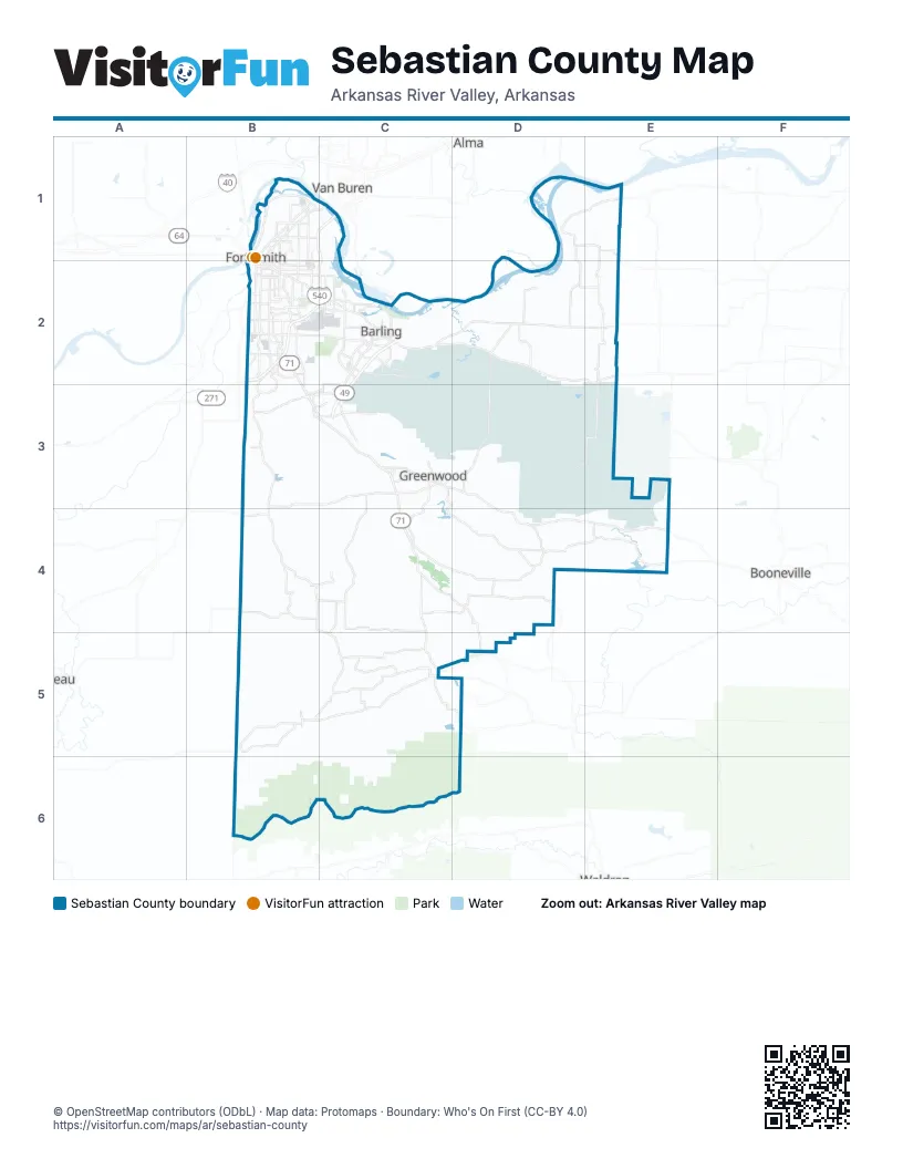
Maps inside Sebastian County
1 map inside, from the street map of Sebastian County down.
Street index of Sebastian County
Each street on the sheet and the grid squares it crosses.
- Rogers AvenueB1, B2, C2
- Zero StreetB2, C2
- Midland BoulevardB1, C1
- Fort StreetC2
- Towson AvenueB2
- West Main StreetD2, E2
- West Center StreetC3, C5
- East Central AvenueC2, D2
- East Center StreetC3, D3, C5
- US Highway 71 SouthB2
- North 10th StreetB1, B2
- North 11th StreetB1, B2
- H StreetC2
- Garrison AvenueB1, B2
- West Central AvenueC2
- Jenny Lind RoadB2, B3
- Hartford Mansfield RoadB5, C5
- Phoenix AvenueB2, C2
- Echo RoadD4
- South Coker StreetC3, C4
- North Main StreetB3, C3, B4
- Old Greenwood RoadB2, C2
- Grand AvenueB1, B2, C2
- Wheeler AvenueB2
- Abbott Cross RoadD4, D5
- Kelley HighwayB1
- South 31st StreetB2
- East Main StreetD2
- Frontier RoadC2
- Church StreetC2, B4
- Excelsior RoadC3
- South 6th StreetB1, B2
- West Elm StreetC3
- Ware RoadD3
- North Waldron RoadB1, B2
- South 5th StreetB1, B2
- South Y StreetB2
- 3rd StreetC2, C4, B5, C5
- BroadwayB5, C5
- Trey Burgess Memorial HighwayC3
- South Waldron StreetB2
- East 2nd StreetB5
- West Crescent StreetC5
- South Waldron RoadB2
- South Main AvenueC5
- Ludlow StreetB5
- Burrough RoadB2
- Carnall AvenueB2
- West Howard StreetC5
- South Main StreetC3, B4
- Garland AvenueB1, B2
- Cedar StreetB3, B4
- East Howard StreetC5
- West Forest StreetC5
- Union RoadD1, E1, E2, D3, E3
- Mount Harmony RoadC3, D3, C4, D4
- Massard RoadC2, C3
- White Oak Mountain RoadD4, E4
- West Browntown RoadC4
- Riverfront DriveB1
- Dayton RoadC4, D4, D5
- Frazier RoadC5
- Old Highway 10E4
- Dallas StreetB2, C2
- North 6th StreetB1, C2, C5
- Chad Colley BoulevardC2, C3
- Tyro RoadB4
- West Hartford RoadB5
- State Line RoadB2
- East Clarks Chapel RoadC4, D4
- Roberts BoulevardC2
- South 28th StreetB2
- Cliff DriveB2, C2
- Douglas RoadC5
- Howard Hill RoadB3, C3
- South 66th StreetC2
- Custer BoulevardC2
- North Albert Pike AvenueB1, B2
- Spradling AvenueB1
- Rye Hill Road SouthC3
- Free Ferry RoadB2, C2
- North 32nd StreetB1, B2
- Park AvenueB2, C2, C5
- Military RoadD2, E2
- South 24th StreetB2
- Steep Hill RoadC2, B3, C3
- Kinkead AvenueB2, C2
- Brooken Hill DriveB2
- Country Club AvenueB2, C2
- West Denver StreetC3
- South 21st StreetB2
- Hill Top HeightsB4, C4
- North 9th StreetB1, B2, C2
- Gary StreetB2, C2
- Wells Lake RoadC2
- South 74th StreetC2
- Cavanaugh RoadB2
- East Lavaca RoadD2
- Sherwood AvenueB3
- Milltown RoadD4
- Taylor AvenueC2
- North 50th StreetB1, B2
- McKennon BoulevardC2
- North O StreetB1
- South 14th StreetB2, C2, D2
- N Street NorthB1
- North E StreetB1, B2
- North B StreetB1, B2
- South 23rd StreetB2
- S Street SouthB2
- Veterans AvenueC2
- South I StreetB2
- West Clarks Chapel RoadC4
- Hendricks BoulevardB2
- North Greenwood AvenueB1, B2
- Dodson AvenueB2
- North 12th StreetB1, B2
- Texas RoadB2
- Houston StreetB2, C2
- East Willis StreetC5, D5
- Rye Hill Road EastB3, C3
- Vicksburg StreetB2
- North 21st StreetB1, B2
- Leigh AvenueB2
- James Fork RoadC5
- Planters RoadB2
- Fianna WayB3
- Independence StreetB2
- Division StreetB1, C3
- South Greenwood AvenueB2
- Meandering WayC2
- North A StreetB1, B2
- South 70th StreetC2
- Moody RoadC2
- North 5th StreetB1
- Old Highway 71B3
- Newlon RoadB1
- U Street SouthB2
- Montreal CutoffB4, C4
- South Fresno StreetB2, C2
- South D StreetB2
- Strozier LaneC2, C3
- Old Highway 71 SouthB3, C3
- Mussett RoadB1
- North 23rd StreetB1, B2
- North S StreetB1
- Riley Park DriveB3, C3
- Valley RoadB2
- B Street SouthB2
- Broadway StreetC5, D5
- South 46 StreetB2
- North 50thB1
- North 3rd StreetB1, C2
- Painter LaneC2
- South Division StreetD2
- McClure DriveC2
- Tut Hill RoadD5
- Grinnell AvenueB2
- Rutgers StreetB2
- Churchill RoadB1
- Ingersoll AvenueB2
- South 42nd StreetB2
- Old Jenny Lind RoadB2
- Steep Hill Cut OffC2, C3
- Knoxville StreetB2
- East Valley RoadB2
- Marshall AvenueC5
- McKinley AvenueB2
- Airport BoulevardB2
- Fort LaneB1
- South 91st StreetC2
- Harriet AvenueB1
- Liberty DriveC3
- Gerber RoadB1
- Westwood AvenueC3
- South 3rd StreetB1, C2
- Jenny Lind AvenueB3
- Waldron StreetB1
- Dale Sadler DriveC3
- Rye Hill RoadB3
- Race Track RoadB2
- Harriet LaneB1
- East Stanfield AvenueB2
- South Cliff DriveC2
- Charlotte LaneB2
- Airport RoadB2
- Huntington AvenueC5
- MarshallC5
- Racetrack RoadB2
- Old US 71 HighwayB3
- SlattenvilleB4
- West Harmony RoadC5, B6, C6
- Mount Zion RoadB3, C3
- Forest Service Road 158B6, C6
- Fort Smith BoulevardC2, D2, D3
- Gap RoadB4, B5
- Nickletown RoadC3, C4
- Poteau Mountain RoadB5, B6, C6
- Bear Hollow RoadB3, C3
- New Hope RoadB4, C4
- South Boundary RoadC3, D3
- Witcherville RoadC4, D4
- Sturgeon RoadB3, C3
- Sugarloaf Mountain RoadB5
- Slaytonville RoadB4
- 1st AvenueC2, C3
- Lone Star WayD3, D4
- North Sugarloaf Mtn Rd-Strozier LaneB5
- Bonanza RoadB3, C3
- Blackjack Mountain RoadD4, D5
- Dawson RoadD4, E4
- East Church StreetC2
- Chocoville RoadC5
- Bermuda Grass LoopB4
- Bethel RoadB3
- Boone RoadC4
- Palestine RoadC4
- Rattlesnake Canyon RoadE3, E4
- School House RoadC4
- Mockingbird Hill RoadC4
- Mountainview RoadC5
- Hendrix RoadC3, C4
- South 16th StreetB2, D2
- Feather Hill RoadD2
- Old Chismville RoadD3
- Johnson RoadC4
- Golf Course LoopB2, C2
- Tennessee Ridge RoadB3
- North 31st StreetB1, B2
- South Pine StreetB5, C5, C6
- East Utah Ranch RoadD2
- Top Fork RoadD4, C5, D5
- Gate Nine RoadC3
- Vineyard Creek RoadC4
- Apple Blossom LoopD4
- North J StreetB1
- West Creek RoadB5, B6
- Reeves RoadC3, C4
- North River RoadD2
- Rice LoopE2
- Johnson StreetB1
- River CrossingC2
- South 22nd StreetB2
- North 18th StreetB1, B2, D2
- Burnville RoadD4
- P StreetC2
- South 17th StreetB2, C2
- Bottom Fork RoadC5, D5
- Courthouse Slough RoadD1
- SpreddingC3
- Johnnie Cake RoadC5
- Old Arko RoadC4, C5
- L Street NorthB1
- Hospital StreetC2
- Bowers LoopC4
- White Bluff RoadB3
- Dalmut RoadC5
- High StreetB1
- Shaver RoadD1, E1
- Arbuckle Island RoadD1
- Jackson StreetB2, C2, C5
- Been Ridge RoadD3
- Spring Mountain RoadB3
- Bugscuffle RoadD2
- North Davis StreetD2
- Patterson RoadC5
- Wirsing AvenueB1
- Park RoadD2
- Mill Creek Mountain RoadE1
- Mackenay Creek RoadC4
- Riddle Creek LoopB5
- Raymond Landtrip RoadD4, D5
- Southshore DriveB4, B5
- Ursula RoadD2, E2
- North 8th StreetB1, C5
- Woods RoadB3, B4
- Doyle Thomas RoadD4
- North I StreetB1
- Butler StreetC2
- North May AvenueB1, B2
- South 10th StreetB2
- Gillham RoadC5
- Mine Six RoadC5
- Young Ridge RoadC4
- Rodeo Arena RoadD2
- North 35th StreetB1, B2
- North 7th StreetB1, C5
- Fort Chaffee BoulevardC2
- Euper LaneB2, C2
- South 25th StreetB2
- Old Wright RoadC4
- Jenson RoadB3, B4
- Crowe RoadD2
- Boston StreetB2, C2, D2
- Pleasant Hill RoadB4, C4
- Turkey Ridge RoadC4
- North County Line RoadE2
- Bucella RoadC4
- North D StreetB1, B2
- 4th AvenueC2
Things to do on the Sebastian County map
Places on the map
- Baptist Health - Fort Smith
- Barling
- Barling City Park
- Bell Park
- Ben Geren Golf Course
- Ben Geren Regional Park
- Bonanza
- Booneville Lake
- Carol Ann Cross Park
- Central City
- Central Mall
- Circle K
- Ebbing Air National Guard Base
- Encompass Health Rehabilitation Hospital of Fort Smith
- Engineer Lake
- Forest Park Cemetery
- Fort Chaffee
- Fort Smith
- Fort Smith ER & Hospital
- Fort Smith Park
- Fort Smith Pavilion
- Greenwood
- Hackett
- Hardscrabble Country Club
- Hartford
- Huntington
- John Bell, Jr. Park
- Kay Rogers Park
- Lake Spur
- Lavaca
- Mansfield Lake
- Mercy Hospital Fort Smith
- Midland
- Sebastian Lake
- Shadow Lake
- Spring Hill Park
- Springhill Park
- Sunnymede Trail
- Sunnymede Trail Park
Next to Sebastian County
- Alma
- Booneville
- Poteau
- Van Buren
© OpenStreetMap contributors, Open Database License, openstreetmap.org/copyright · Map data: Protomaps · Boundary: Who's On First (CC-BY 4.0); Quattroshapes (CC BY 2.0)