

Arkansas map
Fulton County map
About 12,546 people live here (Census Bureau, 2024 estimate). The sheet's index lists 300 streets; State Highway 9, Main Street and Fairview Road cross the most grid squares. Things to do inside the boundary: Mammoth Spring State Park.
Open the map (PDF, US Letter)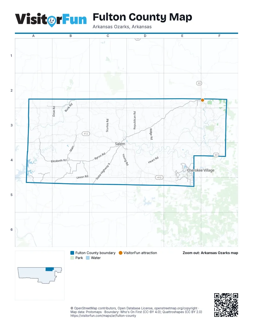
Street index of Fulton County
Each street on the sheet and the grid squares it crosses.
- State Highway 9E2, D3, E3, C4, C5
- Main StreetE2, F2, C3, D3
- South Main StreetC4
- Morning Side LaneC4, D4
- North Main StreetC3, C4
- T & C BoulevardE5
- Elizabeth RoadA3, A4, B4
- State Highway 223B4, B5
- MainB3, B4
- Cherokee RoadE4
- West Church StreetC4
- Saddle RoadE2
- South 14th StreetE2
- Moko RoadC3
- Byron RoadB4, C4
- Stateline RoadA2, B2, F2
- Onaga RoadE4, E5
- Bexar RoadB4
- Greasy Creek RoadB4
- Yankton RoadE4, E5
- Dolph RoadA4, A5
- Tonganoxie RoadE4
- Pottawattamie DriveE4, E5
- Palouse DriveE4, E5
- Bowkers LaneA4, A5
- Pottawattamie RoadE4
- Brushy Creek CoveA4
- Toquo DriveE4
- Kenner RoadE5
- Doris Jean RoadB4
- Hiwassee RoadE4
- County Road 248A5
- Sturkie RoadC2, C3
- Sycamore Creek CircleE2, D3, E3
- Mount Calm RoadA3, B3
- Young RoadC4, D4
- Heart RoadD4, E4
- 9 Mile Ridge RoadE4, F4
- Havenwood RoadB4, C4
- Republican RoadC2, D2, D3
- Kerley Point CoveA4, B4
- Pleasant Valley RoadD2, E2, E3
- North Camp Creek RoadD2, D3
- Whipporwill RoadC4, C5
- Red Bud RoadC2
- Fairview RoadE2, E3, F3, C4
- Baker's Ford RoadE3, E4
- Autumnwood RoadD4, E4
- Walking Stick RoadC3, D3
- Union RoadB4, C4, B5, C5
- French Town RoadD3, E3, D4
- Center Point LoopA4
- Hill String RoadB2, B3, C3
- Buck RoadB2, B3
- Dove RoadB2, A3, B3
- Cedar Park RoadA4, B4
- Missouri Line RoadE2
- Fawnwood RoadA3, A4
- Myatt Creek RoadD2, D3
- Emiline RoadB4, C4
- South Camp Creek RoadD3, D4
- Flora Cemetery RoadB3, B4
- County Road 71F3
- Old Sturkie RoadC3, C4
- Liberty RoadB3, B4
- Long Run RoadF2
- Little Creek RoadA2, A3
- Squirrel Hill RoadD4
- Lime Kiln RoadD3, D4
- Wheeling RoadC4
- Pickren Hall RoadB3
- Fryatt Cemetery RoadE3
- Magnolia RoadC4
- Possum Trot RoadE4, E5
- Browns Chapel RoadB3
- Bayou Access RoadE3, F3
- Woodside RoadA2
- Moonlight RoadF2, F3
- Wild Cherry RoadB4, B5
- Morriston RoadC5, D5
- Finch RoadB4
- Bay Creek RoadC2, C3
- Briarwood RoadB3
- Pine Valley RoadE4
- Roadrunner RoadA2, A3
- Gum Springs CircleC3
- Wood Hollow RoadE5
- Candlewood RoadC3
- Juniper Berry RoadC3, D3
- Golden Star RoadD4, D5
- English Creek RoadE3
- Union Hill RoadF3
- Little Woods RoadA4, B5
- Quail Creek RoadE3
- McGenes Creek RoadA5, B5
- Wirth RoadF3
- Old Ridge RoadC3
- Tall Timber RoadF4
- Moten Cemetery RoadE2, E3
- Ridge RoadD3
- Eagles Nest RoadD4
- Blackberry RoadD4, E4
- Timberline RoadE3
- Hawk Ridge RoadA3
- Amberwood RoadB2, C2
- Big Stone RoadB3
- Flint Springs RoadC3, C4
- Cripple Creek RoadB3
- Sycamore RoadC4
- County Road 85F3
- Timbercrest RoadB3, B4
- Country View RoadC4, D4, D5
- Cornertown RoadD2
- Jaybird TrailA2, A3
- Harmony Hill RoadC4
- Woodlark RoadB2
- Reynolds Island CoveA4
- Hubble Creek RoadD5
- Rose Branch RoadC4
- Asher RoadC2, C3
- Fernwood RoadD4
- Hill Creek TrailE3, F3
- Great Woods RoadE3, F3
- Acorn LaneE3
- The Day RoadD4, D5
- Sunrise RoadC3
- Old Welcome Hill RoadE2
- Ropers CircleD4
- Coyote RoadD3
- Russell Hollow CircleE4
- Wood Vally RoadC4
- Quail RoadA2, A3, B3
- McFadden RoadE4, F4
- River Hill RoadD4
- County Road 98A4
- Kirby RoadC2, C3
- Forest Hill RoadE3
- Mill Creek CircleC3
- River Oaks TrailF3
- Weatherstone RoadF3
- Boggy Point CoveA4
- Vidette RoadA3
- Rockwood RoadB3, C3
- Red Deer TrailB5
- Shady LaneD2, E2
- Holstine LaneA3
- Ruth RoadA4
- Many Islands RoadF3
- Deer Bend TrailD4
- Rock Store LaneB4
- Dove Field RoadD4, E4, D5
- Hebron Church RoadB4
- Elm Creek TrailD3
- Ridgehaven RoadF3
- Red Oak RoadE4, F4
- Holly RoadC4
- Enterprise RoadB3
- Shady Grove RoadC3, C4
- Old Peace Valley RoadD5
- Riverview DriveF2
- Echowood CircleC3
- Spring Wood RoadF4
- Glade Hill RoadA4
- Flora Church TrailB3, B4
- Quail WayA5
- Wren RoadA3
- County Road 73F3, F4
- Seagrave CircleF4
- Wild Cat Ridge TrailE4
- Unicorn RoadC4
- Summit Hill TrailE2
- Pinecrest RoadE4, F4
- Ridgecrest RoadE4
- Beagle Alley RoadB4
- Glade Rock RidgeB3
- Turkey Trott TrailE3, F3
- Crownwood RoadB4
- Deer Run LaneD3
- Oakwood TrailD3
- Katydid RoadD3
- Hiddenwoods TrailB3, B4
- Wild Turkey TrailD3
- Raven Ridge RoadA3
- County Road 2028E3, F3
- Hickory StreetB3
- Gibson Hill RoadE5
- England Cemetery RoadF3
- Pine Ridge RoadA4
- Whittwood RoadC2
- Akicita DriveE4
- Bow Hill TerraceF2
- County Road 84F3
- Countryside RoadB3, A4, B4
- West Firetower RoadF4
- Hualapi DriveE4
- County Road 177C3
- Rainbow Valley TrailF3
- Shilo Cemetery LaneE3
- County Road 48A3, E3
- Boggy Landing CoveA4
- Broadleaf RoadE2
- Hens Nest LaneB3
- Honeytree LaneD3
- Berry Knob LaneC4, C5
- Britton Hill RoadF3
- Ranch TrailC3
- County Road 83F3
- Byhalia TrailE4
- Cedar Glade TrailD3
- Feather Ridge TrailA3
- Round Tree RoadC4
- Foxcroft LaneA4
- County Road 2029F3
- Owl RoadA2, B2
- North Fairview RoadE2, F2, E3, F3
- Red Fox RoadE4, F4
- Leisure LaneD4
- Mulberry RoadC4
- Cherokee Acres DriveE4
- Landfill RoadE4
- Twin Oaks TrailA3
- Forest Mist LaneD3
- Driftwood RoadC5
- Pilot Church LaneE3
- Quilt Palace RoadD4, D5
- Creekside TrailF2
- Walhara DriveE4
- Needle's Eye TrailF3
- Indian Trail RoadD4, D5
- Dry Branch TrailD2
- Redwood LaneD3
- Deep Wood TrailD4
- Foxfield RoadF2
- Country Spring RoadD4, D5
- County Road 288F3
- Osage LoopE4
- Hunter Cemetery RoadD3
- Cricket Pass RoadD3
- Isleta DriveE4
- County Road 293F3
- Chautauqua DriveE4
- Timber Ridge RoadF2, F3
- Gracewood TrailB4
- Cross Creek RoadE5
- Oak View TerraceD4
- Woodtop RoadB2
- Tohatchi DriveE4
- Corkwood RoadC3, C4
- Yamasse RoadE4
- Quanusee DriveE4
- Riverbend RoadF2
- Seminole DriveF3, F4
- Liberty Hill RoadD4
- Old J H Farm TrailD3
- Torchwood TrailC3
- Springwood RoadF4
- Mishemokwa DriveE4
- County Road 178C3
- County Road 295F4
- Hand Cove RoadA3, A4
- Cloverleaf TrailD4
- County Road 311D4, D5
- Conda DriveE4
- Lost River WayE3
- Boy Scout RoadB4
- Ruby Holler LandingA4
- Oho DriveE4
- Papago DriveE4, E5
- Pinal CircleE4
- Mare LaneC4
- Woodstock CircleA4
- Sparrow RoadA2
- Spokane DriveE4
- Homeplace LaneE3
- County Road 243D3
- Bellwood RoadB3, C3
- Leawood LaneA4
- Cedar Valley RoadF3
- Garfield LaneC2
- Riverglen CircleF4
- Spring Wood TerraceF4
- County Road 249D3, A5
- County Road 292F3
- County Road 262D2
- County Road 321D5
- Sunshine LaneD4
- Music Hall LaneF2
- Wedgefield LaneE3
- Bobcat LaneF2
- Stonegate RoadD4
- Wood Valley RoadC4
- Saddle Club RoadE5
- Aspen LaneC3
- Crestview LaneE2, E5
- Riverwood LaneF3
- County Road 296F4
- Chakowin DriveE4
- South 2nd StreetF2, B3
- Wildlife CircleB3
- Walker AvenueE2, F2
Things to do on the Fulton County map
Places on the map
- Agnos Cemetery
- Anasazi Terrace
- Avanyu Trail
- Britton Hill
- Camp Cemetery
- Canuga Circle
- Chautauqua Trace
- Chewase Trail
- Conocross Tc
- Coochunka Trace
- Crazy Horse Trail
- Fulton County Hospital
- Gepp Post Office
- James Lake
- Lake Aztec
- Lake Bertie
- Lake Chanute
- Lake Omaha
- Lake The
- Langston Lake
- Mammoth Spring
- Mammoth Spring State Park
- Mount Mesara
- North Lake Dam
- Osage Loop
- Pine Hill
- Riverside Cemetery
- Salem
- Salem Airport
- Salem City Park
- Salem Knob
- Shaw Knob
- Southern View Aviation Airport
- Spring River
- Turkey Knob
- Viola
- Viola City Park
- Wallace Knob
- Warm Fork
- Wildcat Knob
Next to Fulton County
- Cherokee Village
© OpenStreetMap contributors, Open Database License, openstreetmap.org/copyright · Map data: Protomaps · Boundary: Who's On First (CC-BY 4.0); Quattroshapes (CC BY 2.0)















