

Arkansas map
Malvern map
About 11,082 people live here (Census Bureau, 2024 estimate). The sheet's index lists 276 streets; South Main Street, Riverview Drive and Military Road cross the most grid squares. Also on it: Malvern City Park, Ouachita River Unit and Centennial Park.
Open the map (PDF, US Letter)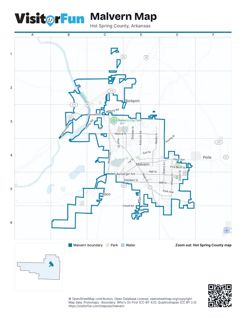
Street index of Malvern
Each street on the sheet and the grid squares it crosses.
- Del Rio LoopsC1
- Hunters Run StreetB2
- Riverview DriveB2, C2, C3
- Riverview RoadB2, C2
- Gibson DriveC2
- Industrial RoadC2, D2
- Leopard LaneC2
- Long DriveC2
- Long StreetC2
- Martin Luther King RoadC2
- River Creek RoadC2, C3
- Military RoadD2, C3, D3
- Dusty RoadB3, C3
- Halton RoadB3
- State Highway 84 WestB3
- Tanner StreetB3, C3
- West Moline StreetB3, C3, D3
- Brownwood StreetC3
- Cemetery DriveC3
- Collie RoadC3, D3
- Division StreetC3, D3, D4
- Edgewood CircleC3
- Gardiner StreetC3
- Halbert AvenueC3, C4
- Herford DriveC3
- Martin Luther King BoulevardC3, C4, D4
- Mc Kinley StreetC3, D3
- Mc MillanC3
- Miller AvenueC3
- North Park DriveC3, C4
- Oliver Lancaster BoulevardC3
- Park DriveC3, C5
- Park RoadC3, C4
- Pinehurst DriveC3
- Rockport RoadC3, D3, D4
- Walco DriveC3, C4
- Babcock RoadD3, D4
- Baker StreetD3, D4
- Broadway StreetD3
- Collie DriveD3
- CrenshawD3
- East Moline StreetD3
- Elm StreetD3
- Fairview StreetD3, D4
- Fall StreetD3, D4
- Floyd StreetD3, D4
- Gough StreetD3
- Grayson CircleD3
- Griggs StreetD3, D4
- Hoover StreetD3, D4
- Industrial LaneD3
- Iva StreetD3
- Lowden StreetD3, D4
- MagnoliaD3
- Main StreetD3
- Mc Coy StreetD3
- Mc NeelyD3, D4
- McAlister StreetD3
- Mount Willow RoadD3
- North Banks StreetD3, D4
- North Main StreetD3, D4
- Nottingham StreetD3
- Pacific StreetD3, D4
- Quinn StreetD3
- Reyburn RoadD3
- Sand RoadD3
- Sherwood DriveD3
- Union StreetD3
- Watt StreetD3
- West StreetD3
- 3rd StreetC4, D4
- AcmeC4, D4
- Barnett StreetC4
- BergerC4, D4
- Bryant StreetC4
- Burris RoadC4
- Cabe AvenueC4, D4
- Charity StreetC4
- Church StreetC4
- Clark StreetC4
- Elmo StreetC4, D4
- FaithC4
- Happy StreetC4
- Harris StreetC4
- Henry StreetC4, D4
- HopeC4
- Hope CourtC4
- Kelly StreetC4
- Love StreetC4
- Marigold StreetC4
- Morzett StreetC4, C5
- North Walco RoadC4
- Now Young RoadC4
- South Park DriveC4, C5
- South Walco RoadC4, C5
- Spruce StreetC4, D4, C5
- Turner StreetC4, C5
- West Berger StreetC4
- West Young StreetC4, D4
- Babcock StreetD4
- Babcock TerraceD4
- Bell StreetD4
- ClardyD4, E4
- Clardy StreetD4
- Clem StreetD4, E4
- Cross StreetD4
- Davis StreetD4
- Dyer StreetD4, D5, D6
- East 1st StreetD4
- East 2nd StreetD4
- East 3rd StreetD4
- East BergerD4
- East Front StreetD4
- East Page AvenueD4, E4
- East Young StreetD4
- Edwards StreetD4, D5
- Elizabeth AnnD4
- Gail StreetD4
- Gloster CourtD4
- Hall StreetD4, D5
- Hot Spring StreetD4
- Keith StreetD4
- LaurelD4
- Locust StreetD4, D5
- Mann StreetD4
- Mc ClureD4
- McBee StreetD4, E4
- McElure StreetD4
- McNeal StreetD4, D5
- Mississippi StreetD4, D5
- Moore StreetD4
- North Laurel StreetD4
- Oak StreetD4, D5
- Olive StreetD4, D5
- Overman StreetD4
- Pate StreetD4
- Pecan StreetD4, D5
- Pine Bluff StreetD4, E4
- School StreetD4, D5
- Section Line StreetD4, E4
- Sheppard StreetD4
- South Ash StreetD4
- South Banks StreetD4
- South Main StreetD4, D5, D6, E6
- St CrossD4
- Stadium DriveD4
- Stanley StreetD4, D5
- Stewart StreetD4
- Susan StreetD4
- Swan StreetD4
- Truman StreetD4
- Veneer StreetD4
- Vine StreetD4, D5
- WalnutD4, D5
- West 1st StreetD4
- West 2nd StreetD4
- West 3rd StreetD4
- West 5thD4, D5
- West 6th StreetD4, D5
- West Front StreetD4
- West Page AvenueD4, D5
- Young StreetD4, E4
- Canine RoadE4
- Carolyn StreetE4
- Cherry LaneE4, E5
- Circle DriveE4
- Dawson StreetE4, E5
- Delano DriveE4
- Dogwood DriveE4
- Dogwood TrailE4
- Forest StreetE4
- Garland StreetE4
- Grant StreetE4
- Jefferson StreetE4, E5
- King StreetE4, E5
- LegionE4
- Lincoln StreetE4, E5
- Maurice StreetE4
- Mc LeanE4, E5
- Mockingbird LaneE4
- Orchard StreetE4
- Owen StreetE4, E5
- Robert E Lee StreetE4
- Roosevelt StreetE4, E5
- Scheider DriveE4
- Scheider RoadE4, E5
- Schneider DriveE4
- Toler StreetE4, E5
- Wallace StreetE4, E5
- Whitehouse StreetE4
- Wilson StreetE4, E5
- WoodlandE4
- Grigsby Ford RoadB5, C5
- Acme StreetC5
- Birch StreetC5
- Oaklawn StreetC5, D5
- Shirley DriveC5
- Sunset StreetC5, D5
- Walco LaneC5
- West Highland StreetC5, D5
- West Sullenberger AvenueC5, D5
- West Sullenberger RoadC5
- Alabama StreetD5
- Azalea DriveD5
- Carmichael StreetD5
- CharlotteD5
- Earnest StreetD5
- East Donnelly StreetD5
- East Highland AvenueD5, E5
- East Mill StreetD5, E5
- East Sullenberger AvenueD5, E5
- EastonD5
- Evans StreetD5
- Georgia StreetD5
- Harper StreetD5, E5
- Howard StreetD5
- Jester StreetD5
- Kirkland StreetD5
- Leon StreetD5
- Lillian StreetD5
- Louisiana StreetD5
- McHenry StreetD5, E5
- MeyerD5
- Pleasant StreetD5, E5
- Potts StreetD5
- Rock StreetD5
- Rosebud DriveD5
- Schley StreetD5
- Smith StreetD5
- Sulphur Springs RoadD5, E5
- SunD5
- Texas StreetD5
- West Donnelly StreetD5
- West Mill StreetD5
- Willow StreetD5, E5
- Bailey PlaceE5
- Bayer StreetE5
- Briarwood DriveE5, E6
- BridgewoodE5
- Fowler AvenueE5
- Garden CircleE5
- Glenmere CircleE5
- Glover StreetE5
- Hillcrest StreetE5
- JonesE5
- Linda LaneE5
- Maple StreetE5
- Mc HenryE5
- Mimosa DriveE5
- Monroe StreetE5
- Oakwood DriveE5, E6
- Park AvenueE5
- Pine Hill CircleE5
- Porter StreetE5
- Reed StreetE5
- Regal DriveE5
- Regency DriveE5
- Rolling Hill DriveE5
- Royal Oaks DriveE5
- Shady CircleE5
- Shady LaneE5
- Southgate DriveE5, E6
- Star RoadE5, E6
- Sulton StreetE5
- Taylor StreetE5
- West Pine DriveE5
- Apollo StreetD6
- Cloud RoadD6
- Larkin StreetD6
- Rocket StreetD6
- Saturn StreetD6
- Windcrest RoadD6
- Oakhill DriveE6
- Oakwood CircleE6
- Southgate CircleE6
- Valleyview DriveE6
Places on the map
- Arby's
- Arkansas State University Three Rivers
- Baptist Health Medical Center-Hot Spring County
- Baptist Temple of Malvern
- Bethel African Methodist Episcopal Church
- Burger King
- Calvary Church of God in Christ
- CAT Scale
- Centennial Park
- Church of Christ
- Citgo
- Comfort Inn
- Dollar General
- Domino's
- Emmanuel Baptist Church
- Fairhaven Missionary Baptist Church
- Faith Baptist Church
- Faith Temple Apostolic Church
- First Assembly of God Church
- First Baptist Church
- First Presbyterian Church
- First United Methodist Church
- Holiday Inn Express & Suites
- Hot Spring County Courthouse
- Love's Travel Stop
- Malvern City Hall
- Malvern City Park
- Malvern Post Office
- Malvern-Hot Springs County Library
- McDonald's
- NAPA Auto Parts
- Oak Ridge Cemetery
- Ouachita River Unit
- Ouachita River Whitewater Park
- Regions Bank
- Stihl Southwest
- Tractor Supply Company
- Walgreens
- Walmart Supercenter
Next to Malvern
- Abco
- Perla
- Rockport
© OpenStreetMap contributors, Open Database License, openstreetmap.org/copyright · Map data: Protomaps · Boundary: Who's On First (CC-BY 4.0); Quattroshapes (CC BY 2.0)















