

Arkansas map
Arkansas Ouachitas map
The sheet's index lists 12 highways; US 270, US 71 and I-30 cross the most grid squares. Things to do inside the boundary: A Narrow Escape, Adventureworks and Arkansas Alligator Farm & Petting Zoo. Also on it: Arkadelphia, Hot Springs and Hot Springs Village.
Open the map (PDF, US Letter)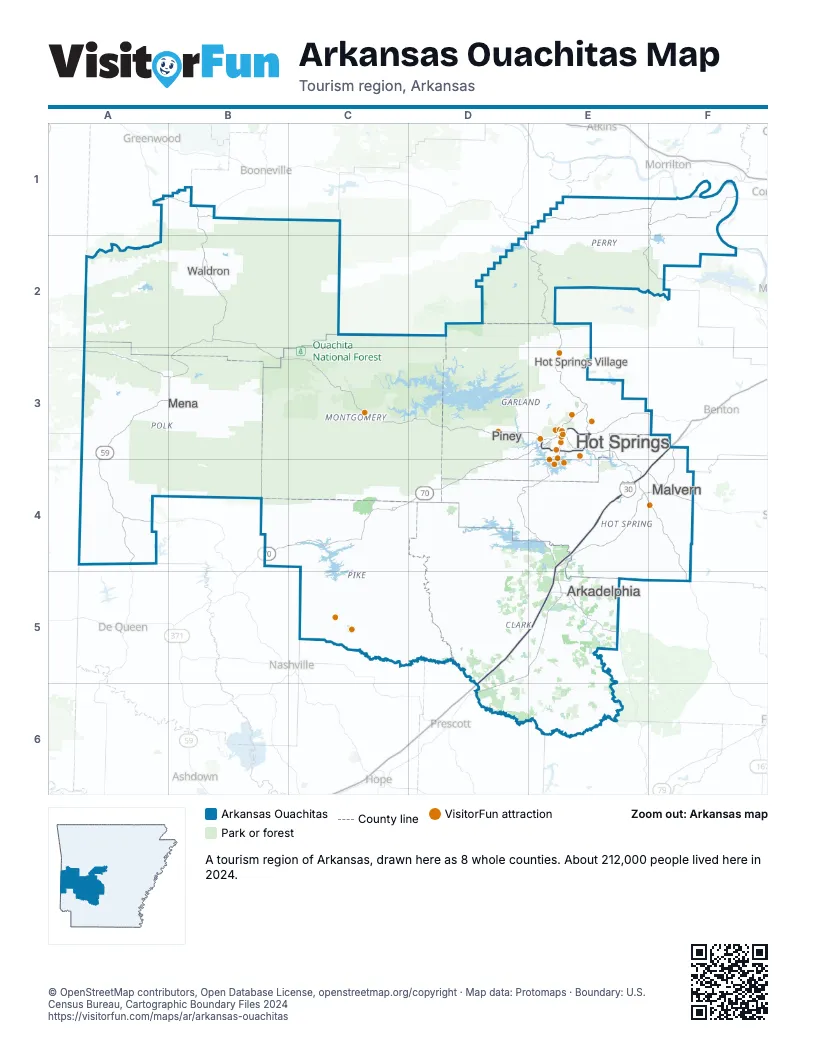
Highway index of Arkansas Ouachitas
Each highway on the sheet and the grid squares it crosses.
- I-30D5, E4, E5, F3, F4
- US 59A3, A4, B3
- US 70B4, C4, D3, D4, E3
- US 70BE3
- US 71A1, A3, A4, B1, B2, B3
- US 270B2, B3, C3, D3, E3, E4, F4
- AR 5E3
- AR 7D2, D4, E2, E3, E4
- AR 8A3, C4
- AR 27C3
- AR 88C3
- AR 246A3, A4
Things to do on the Arkansas Ouachitas map
- A Narrow Escape
- Adventureworks
- Arkansas Alligator Farm & Petting Zoo
- Avant Mining Fisher Mountain
- Bathhouse Row
- Buckstaff Bathhouse
- Chez Fur Fiber Farm
- Crater of Diamonds State Park
- Crystal Ridge Distillery
- Dryden Pottery
- Fox Pass Pottery
- Funtrackers Family Fun Park
- Garvan Woodland Gardens
- Historic Malco Theatre
- Hot Springs Gallery Walk
- Hot Springs Marina
- Hot Springs Mountain Tower
- Hot Springs National Park
- Hot Springs Off-Road Park
- Hot Springs Trolleys
- It's About Rocks
- Ka-Do-Ha Indian Village
- Lake Catherine State Park
- Machine Gun Grotto
- Magic Springs Theme and Water Park
- Mountain Harbor Riding Stables
- National Park Duck Tours
- Oaklawn Racing Casino Resort
- Queen Wilhelmina State Park
- Retroverse Museum
- Ron Coleman Mining
- Sunbay Resort
- The Golf Shack
- The Purple Cow
- The Wharf Resort
- The Winery of Hot Springs
- TNT Fun Play
- Wake Zone
- Wegner Quartz Crystal Mines
Places on the map
- Arkadelphia
- Hot Springs
- Hot Springs Village
- Malvern
- Mena
- Piney
- Waldron
Next to Arkansas Ouachitas
© OpenStreetMap contributors, Open Database License, openstreetmap.org/copyright · Map data: Protomaps · Boundary: U.S. Census Bureau, Cartographic Boundary Files 2024