

Arkansas map
Pope County map
About 64,829 people live here (Census Bureau, 2024 estimate). The sheet's index lists 300 streets; State Route 7 North, Pine Street and Victor Road cross the most grid squares. Things to do inside the boundary: Russellville.
Open the map (PDF, US Letter)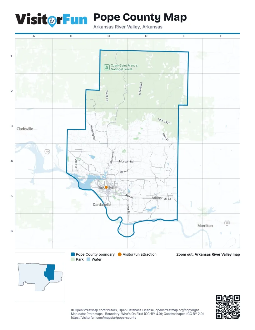
Maps inside Pope County
1 map inside, from the street map of Pope County down.
Street index of Pope County
Each street on the sheet and the grid squares it crosses.
- State Route 7 NorthC1, C2, C3, C4
- North Arkansas AvenueC4, C5
- East Main StreetC5, D5
- West Main StreetC5, D5
- US 64D5, E5
- South Arkansas AvenueC5
- Main StreetE3, E4, D5
- South Market StreetC4
- Camp StreetC4
- Market StreetC4
- East Aspen LaneC5
- AR 331C5
- Mission RoadC4
- Lakewood DriveC4
- Dwight Mission DriveC4
- State Highway 105D4, D5, D6
- AR 124C4, D4, C5
- AR 333B4
- West Parkway DriveC5
- East Parkway DriveC5
- Pless Community RoadB4
- South Knoxville AvenueC5
- North Church StreetD5
- Weir RoadC5
- Bernice AvenueC5
- North Knoxville AvenueC5
- State Highway 164B3
- State Highway 123C1
- Rushing RoadB3, C3, C4
- Crow Mountain RoadC5, D5
- Buttermilk RoadD4, E4
- Pilot Rock Mountain RoadB2, C2, C3
- Morgan RoadC4, D4
- River RoadD5, D6
- Pine Ridge RoadD5
- Mill Creek RoadB4, C4
- Alpine Meadows RoadD5
- Pleasant View RoadB4, C4
- Saint Joe RoadD4, E4
- Hudson RoadD5
- Walnut Valley RoadC3
- Bailey Loop RoadB4
- Skyline DriveC5
- Bradley Cove RoadC5, D5
- Maple Springs RoadD5
- Crites RoadD4, E4
- Marina RoadC5
- Talley LaneE5
- Happy Bend RoadE5
- South Frankfort AvenueC5
- Mount Carmel Road WestB4
- Center Valley RoadC4
- Hickeytown RoadB4
- Murdoch RoadD4, D5
- South Elmira AvenueC5
- Ball Hill RoadB4, C4
- Bells Chapel Road EastD5
- Roy Taylor RoadC4
- Country Club RoadC4
- Pisgah RoadC5, D5
- Hilltop DriveC5
- Huckleberry Road EastB4, C4
- Southwest 3rd StreetD5
- Shiloh RoadC4
- Gold Hill RoadD5, D6
- Isabell Creek RoadD4
- West Ash StreetC5, D5
- Slabtown RoadC4
- Hartwick LaneE4, D5, E5
- Hopewell RoadD5
- Bells Chapel Road WestD5
- Tyler RoadC5
- Dwight Mission RoadC4
- Lake Front DriveC5
- Linsey Hill RoadC3
- Avenue 3 SoutheastD5
- North Phoenix AvenueC5
- Sparksford DriveC5
- Lock and Dam RoadC5
- East 6th StreetC5
- Old Cove RoadC5
- Georgetown RoadB4
- Old Highway 124C5
- South Glenwood AvenueC5
- South Detroit AvenueC5
- Hob Nob RoadC5
- West 12th StreetC5
- Jimmy Lile RoadC5
- Marina WayC5
- South Inglewood AvenueC5
- Page RoadD5
- Fairway BoulevardC5
- Sequoyah WayC5
- East Ash StreetD5
- East 16th StreetC5
- East 4th StreetC5
- North Detroit AvenueC4, C5
- West 2nd StreetC5
- East 19th StreetC5
- North El Paso AvenueC5
- East O StreetC5
- Bradley LaneC5
- South Vancouver AvenueC5
- West 8th StreetC5
- Russell RoadC5
- Lake Ridge DriveC4
- South Phoenix AvenueC5
- Sheppard DriveC5
- Galla Park RoadD5
- East J StreetC5
- Damascus RoadC5
- South Macon AvenueC5
- South Union Grove RoadE5
- Williamson WayC5
- International Paper RoadC5
- West Union Grove RoadE5
- East H StreetC5
- North Parker RoadC5
- Honeysuckle LaneC5
- Northeast 18th StreetD5
- Summerglow RoadD5
- Industrial BoulevardC5
- Teeter RoadD5
- Bliss LaneC5
- North Elmira AvenueC5
- River View RoadC5
- Talley Lane LoopE5
- South Church StreetD5
- Crow Mountain DriveD5
- Southeast 3rd StreetD5
- West 3rd CourtC5
- Airport RoadC5
- North Hampton AvenueC5
- North Denver AvenueC5
- Hickory Hollow LaneC5
- West Main PlaceC5
- South Maple StreetC4
- Avenue 2 SoutheastD5
- West G StreetC5
- North Fork RoadD2, D3
- Old Hwy 27D1, D2, D3
- Indian Creek RoadC1, C2
- Nfm 1301D3, E3
- Sulphur RoadC1, D1, D2
- Buck Mountain RoadC4, D4
- Treat RoadC2
- Pine StreetD3, E3, B4, C4
- Adams Mountain RoadD2, D3
- Victor RoadC1, D1, C2, D2
- Griffin Flat RoadE4
- Smyrna RoadD1, E1, D2, E2
- Old 7 HighwayC2, C3
- Maupin Flat RoadC1, C2
- Page Hollow RoadC2
- Ross Mountain RoadB3, C3
- Lindsey MotorwayD2, E2, D3, E3
- Broomfield RoadC3, D3
- Granny Gap 1 RoadD3
- White Oak Mt RoadE2
- Evans Mountain RoadE3
- Granny Gap 2 RoadC3, D3
- Pine Hill RoadC3, C4
- Cloud Mountain RoadD3, D4
- Gunter Mountain RoadD3
- Linker Mountain RoadC4
- Cannaday Flat RoadD3, E3
- Falling Water RoadD1
- New Three Knob Mountain RoadC3
- Seymor RoadC2, C3, D3
- Augsburg RoadB3, B4
- Bradfield RoadD4
- Landers Loop RoadC4
- Boyd RoadD1, C3
- Wallace Ridge RoadC3
- Rock Hollow RoadD3, D4
- Eubanks RoadB3, C3, B4
- Bench RoadD3
- County Road 1806C2
- Worthen RoadD5
- Larue Ridge RoadC3
- Southeast 4th StreetD5, E5
- Howell RoadC5, C6
- Ember RoadB3
- Shinn Moutain LoopC4
- Whorton Mountain RoadB4
- Meadows Knob RoadC2
- Dare Mine RoadC2
- Neely Hollow RoadE1
- East Gum Log RoadC4, D4
- Dabney RoadE2
- Llewellyn LoopD3
- Davis RoadD5, D6
- West Gumlog RoadC4, D4
- Walnut Grove RoadD3
- Hickey Mountain LoopB4
- North Shore RoadD5
- Edwards RoadD5
- Slover Creek RoadB3
- Tucker Mountain RoadC4
- Narrow RoadC5, D5
- Illinois Bayou RoadD2, E2
- Newton Knob RoadC2
- North Linker DriveC4
- Postal RoadD3, D4
- Gravel Hill RoadD4
- Long Pool RoadC2, C3
- Memory LaneE1, E2
- Cedar Grove RoadD3
- Silex RoadB3, C3
- Atkins Bottom RoadD5, E5
- Black Land RoadE5
- Taylor LoopE5
- Jakes Creek RoadB2, C2, C3
- Albert DriveC4, D4
- Millsap LaneC3
- Radford LaneD4, D5
- West Chimney Rock RoadB4
- Worshaw Mountain DriveB3, C3
- Iron Ore Mtn RoadD4
- Granny Hollar RoadE4
- Sweeden RoadC5
- Vaughns CircleC4, D4
- Upper Pine Ridge RoadD4
- Lee Mt RoadC3
- Duvall RoadD4
- Paradise Acres RoadC4, D4
- Will Baker RoadB4
- Pollard Cemetery RoadC3
- Pless School RoadB3, B4
- Smoke Tree RoadC3
- Caglesville LaneD4
- West C StreetC5
- Lodge RoadC6
- Quail Hollow RoadC4
- Old Baptist Cemetery RoadC4
- Rock Springs Loop RoadD3, D4
- Old Woods RoadC6, D6
- Twin Dikes RoadD5
- Bowers LoopC4
- Uellner Rd EastB4
- Wheeler Bend RoadC4
- Fronabarger RoadD5
- Bayou Ridge LoopC4
- Churchill RoadE4
- Graves Creek RoadC2
- Oak StreetD3, C4
- Freeman RoadC2, D2
- Reed LoopD5
- Payne Ridge RoadC2, D2
- Elm Hollow RoadD3
- Union Grove LoopD5, E5
- Knoxville RoadB4
- Barber RoadD4
- Bakers Creek RoadC4
- North Frankfort AvenueC4, C5
- McDonald RoadE2
- Stafford RoadD3
- McHenry RoadC5
- Meadows KnobB2
- Newton Spring RoadD3
- Hurley RoadC4
- Northeast 4th StreetD5
- Mt Vernon RoadE4
- Meimerstorf LaneB4
- Cliff RoadD5
- Hogan Roberts LoopD4, D5
- Rachel RoadC4
- Goates RoadC3, D3
- New Hope RoadD3, D4
- Simba RoadE4
- May RoadB4, B5
- Welcome Home RoadE3
- Flag Lake RoadC6, D6
- County Road 1840C1
- Ball Park RoadC4, D4
- Mount Zion Road WestE3, E4
- Nosser DriveC3
- Race RoadC5, D5, C6
- Lower Pine Hill RoadD4
- Jennings RoadC5
- North Hartford AvenueC4, C5
- Upper McGuire LoopC5
- Hurricane RoadD5, E5
- Terra Villa RoadC4
- Lake RoadD5
- Nfm 1325D3
- Hutcherson RoadC5
- East L StreetC5
- Loop RoadD6
- Crooked Branch RoadC3
- North Hopewell LoopD5, E5
- Pine Twist RoadB4
- Round Rock RoadC4
- South Hopewell LoopD5
- East 2nd StreetC5
- Gunter Mountain DriveD3
- Alaskan TrailC5
- Hide-A-Way LaneB4
- County Road 1802C1
- Main RoadC6
Things to do on the Pope County map
Places on the map
- Adams Mountain
- All Secure Mini Storage
- Alread Hill
- Arkansas River
- Arkansas Tech University
- Atkins
- Atkins Cemetery
- Augsburg Mountain
- Bald Knob
- Blue Hole Special Interest Area
- Bona Dea Trails and Sanctuary
- Condley Lake
- Dardanelle Marine Terminal
- Dover
- East Fork Wilderness
- East Point Mountain Forest Area
- Galla Creek Lake
- Galla Park
- Hector
- Holla Bend
- Illinois Bayou Park
- Lake Atkins
- Lake Dardanelle State Park
- Landers Loop Airport
- Legends Casino And Resort (Proposed)
- Lock and Dam Soccer Park
- London
- Mack's Pines RV Park
- Old Post Road
- Old Post Road Park
- Ozark-Saint Francis National Forest
- Pedestal Rocks Special Interest Area
- Penhook Special Interest Area
- Pope County Fairgrounds
- Pottsville
- Russellville
- Russellville Regional Airport
- Sweeden Island Park
- Valley Park Centre
- Waldo/Wainscott Special Interest Area
Next to Pope County
- Clarksville
- Dardanelle
- Morrilton
© OpenStreetMap contributors, Open Database License, openstreetmap.org/copyright · Map data: Protomaps · Boundary: Who's On First (CC-BY 4.0); Quattroshapes (CC BY 2.0)















