

Arkansas map
Russellville map
About 29,442 people live here (Census Bureau, 2024 estimate). The sheet's index lists 300 streets; North Arkansas Avenue, West C Street and East Main Street cross the most grid squares. Also on it: Bona Dea Trails and Sanctuary, Lake Dardanelle State Park and Old Post Road Park.
Open the map (PDF, US Letter)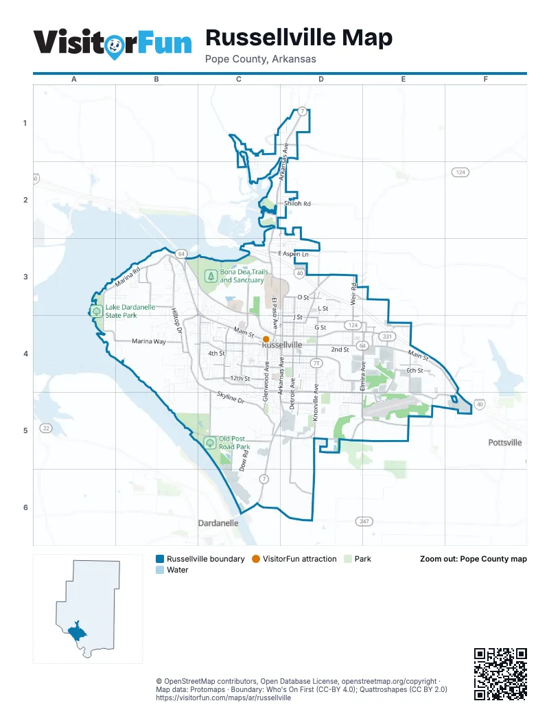
Street index of Russellville
Each street on the sheet and the grid squares it crosses.
- North Arkansas AvenueD1, C2, D2, C3, D3, D4
- East Main StreetD4, E4, F4, F5
- South Arkansas AvenueD4, C5, D5, C6
- West Main StreetB3, C3, C4, D4
- East Aspen LaneC3, D3
- South Market StreetD1
- AR 331E4
- West Parkway DriveB3, C3, C4, D4
- East Parkway DriveD4, E4
- South Knoxville AvenueD4, D5
- Weir RoadD3, D4
- Bernice AvenueC5, D5
- North Knoxville AvenueD3, D4
- AR 124D3
- Skyline DriveC3, B4, C4, C5
- Marina RoadA3, B3, A4
- South Frankfort AvenueD4, D5, D6
- South Elmira AvenueE4, D5, E5
- Hilltop DriveB3, B4
- Lake Front DriveB3, C3
- Tyler RoadE4, E5
- North Phoenix AvenueC3, C4
- Lock and Dam RoadB5, C5
- East 6th StreetD4, E4
- South Glenwood AvenueC4, C5
- South Detroit AvenueD4, D5
- Hob Nob RoadD3, E3, E4
- West 12th StreetC4
- Jimmy Lile RoadD5, E5
- Marina WayA4, B4
- Old Highway 124D3
- South Inglewood AvenueC4
- Fairway BoulevardD4, E4
- Sequoyah WayC4, D4
- East 16th StreetD4, D5, E5
- East 4th StreetD4, E4
- North Detroit AvenueC2, D2, D3, D4
- West 2nd StreetC4, D4
- East 19th StreetD5, E5
- North El Paso AvenueC3, C4
- East O StreetD3
- Bradley LaneC4
- South Vancouver AvenueC4
- West 8th StreetC4, D4
- Russell RoadD4, E4
- South Phoenix AvenueC4
- Sheppard DriveC4, C5
- East J StreetD4
- Damascus RoadB3
- South Macon AvenueE4, E5
- Williamson WayD4, D5
- International Paper RoadC5, C6
- East H StreetD4, E4
- North Parker RoadD3, D4
- Honeysuckle LaneB4, C4
- Industrial BoulevardE5, F5
- Bradley Cove RoadE4
- Bliss LaneB3
- North Elmira AvenueE4
- River View RoadB3
- Sparksford DriveD3
- West 3rd CourtC4
- Shiloh RoadC2, D2
- Airport RoadE5
- North Hampton AvenueE4
- Center Valley RoadD1
- Pleasant View RoadC2
- North Denver AvenueC3, C4, D4
- Hickory Hollow LaneC4
- West Main PlaceB3, C3, C4
- Country Club RoadD1
- Old Cove RoadF4
- West Ash StreetE5
- West G StreetD4
- West C StreetB3, C3, C4, D4, E4
- North Frankfort AvenueD2, D3, D4
- East L StreetD3
- East 2nd StreetD4, E4
- West 4th StreetC4, D4
- South Cleveland AvenueD4, D5
- North Erie AvenueD2, D3, D4
- East 5th StreetD4, E4
- North Greenwich AvenueD3, D4
- North Hartford AvenueD2, D3, D4
- West B StreetC4, D4
- North Glenwood AvenueC3, C4
- East Gum StreetC2, D2, D3
- South Hartford AvenueD4, D5
- West 3rd StreetB4, C4, D4
- South Independence AvenueC4
- South Seattle AvenueC4
- South El Paso AvenueC4, C5
- South Commerce AvenueC4, C5
- South Denver AvenueC4
- South Boston AvenueD4, D5
- South Erie AvenueD4, D5
- Dawn CircleA3, B3
- West 3rd PlaceC4, D4
- East 8th StreetD4
- South Ithaca AvenueD4, D5
- East G StreetD4
- North Boston PlaceD3, D4
- South Boulder AvenueC4, D4, C5, D5
- East 13th StreetD4
- Beach RoadA3, A4
- Water Works RoadC1, D1
- South Greenwich AvenueD4, D5
- Dow RoadC5, C6
- North Cleveland AvenueC3, D3, D4
- University DriveD3, D4
- East 12th StreetD4
- Riverstone StreetC5
- East 11th StreetD4
- West 2nd CourtB4, C4
- East 10th StreetD4
- East M StreetD3
- South Houston AvenueC4
- West 2nd PlaceC4
- Old Post RoadB4
- East E StreetD4
- South Tampa AvenueD4, D5
- West 6th StreetC4, D4
- East F StreetD4
- North Boston AvenueC3, D3, D4
- North Sidney AvenueD3, D4
- South Laredo AvenueC4
- East N StreetD3
- South Tulsa AvenueC4
- South Utica AvenueD4, D5
- Randall CircleC1, C2
- West 5th StreetC4, D4
- East Elm StreetC3, D3
- South Jackson AvenueD4, D5
- North Louisville AvenueD3, D4
- South Durant AvenueC4
- East 14th StreetD4
- South Verona AvenueD4, D5
- East 17th StreetD5, E5
- Turrentine WayB4
- East 3rd StreetD4
- Skyline Vista LaneB4
- East Fir StreetC3, D3
- Ridgewood DriveC4
- South Pittsburg AvenueD4, D5
- Promenade CircleC4
- South Sidney AvenueD4, D5
- East B StreetD4
- East Harrell DriveC3, D3
- West 14th StreetC4, D4
- West 4th PlaceC4
- South Waco AvenueC4
- East C StreetD4, E4
- East K StreetD3
- South Jonesboro AvenueC4
- West 7th StreetC4, D4
- Hilltop PlaceB4
- Old Post Park RoadC5
- East 22nd StreetD5
- Ashbrook LaneD5
- Mall DriveE4
- East 9th StreetD4
- Barborek LaneA4, B4
- North Jackson AvenueD3, D4
- West 13th StreetC4, D4
- West E StreetC3, C4
- Tanglewood DriveC4
- North Ithaca AvenueD3, D4
- Reasoner LaneC3, D3
- West 18th StreetC5, D5
- South Boston PlaceD4, D5
- South Muskogee AvenueC4
- West 17th TerraceC4, C5
- West 19th StreetC5, D5
- South Quincy AvenueD4, D5
- Muscadine LaneC4
- Limestone CircleD2
- Pleasant Hills DriveB4
- South Enid AvenueC4
- West L StreetC3, D3
- West 17th StreetC5, D5
- Amy Lyn CircleB3
- Dowdy LoopB3, B4
- North Joplin AvenueC3
- Nordin LaneB4, C4
- South Quanah AvenueC4
- Vista RoadA3, A4
- Private DriveC4
- East 7th StreetD4
- West 18th TerraceC5
- South Arlington AvenueC4
- Skyline Vista CourtB4, B5
- West Harrell DriveC3
- West Birch StreetC3
- Ashford DriveD5
- Ashley DriveD5
- East Date StreetC3, D3
- West R StreetC3, D3
- Whipporwill LaneC4
- South Cumberland AvenueC4
- Preston DriveB3
- East Holly StreetC2, D2
- Castlegate LoopC5
- Outdoor CourtC3
- Tanya CircleB3
- East 15th StreetD4
- Steel City LaneD3
- East Spokane CircleB3, C3
- River Oaks LaneB4
- West D StreetC3
- North Boulder AvenueC3, D3
- North Nashville AvenueD3, D4
- South Utah AvenueC4
- Canterbury CircleB3
- Bernard WayE4
- South Rochester AvenueD4, D5
- Quarry RoadC4, C5
- Shalimar CircleB4
- Western DriveC5
- North Fargo AvenueC3, C4
- Austin CircleB3
- County Complex CircleD4
- West 23rd StreetC5, D5
- Highland DriveB4
- West 21st StreetC5, D5
- Mall Service RoadE4
- South Oswego AvenueD4, D5
- North Inglewood AvenueC3
- East K PlaceD3
- West Norristown CircleB4
- Quapaw DriveB3
- West 10th StreetC4, D4
- Lands End Point SouthB4, B5
- Washburn ParkB3
- Bakers Creek RoadD1
- West K StreetC3, D3
- Bakers Spring RoadC5
- High Acres DriveB3
- Rim Rock RoadB5
- North Mobile AvenueD3, D4
- Resimont DriveC4
- North Independence AvenueC4
- Okie Doke RoadC6
- Southgate DriveC5
- Treaty Line DriveB3, B4
- North Shore DriveB3
- East Shore DriveB3
- East Norristown CircleB4
- Lakeview CircleB3
- West Q StreetC3
- South Omaha AvenueC4
- Thornwood LaneD2
- West Circle DriveC4
- East 23rd StreetD5
- Ouita CircleB3
- Sweeden RoadE5
- North Tulsa AvenueC4
- East Circle DriveC4
- Speed Shop RoadD5
- West C PlaceC4
- Midway DriveC6
- East 39th StreetC6
- Davis DriveD4
- West 2nd LaneC4
- Airways DriveE5
- Lexington AvenueE4
- Ramp LoopA3
- Sagewood LaneD2
- North Jonesboro AvenueC4
- Vest LaneD1
- Lakewood CircleA3
- Craigwood CircleB4
- Lands End Point NorthB4
- Finley LaneD5, E5
- Kovel CourtC5
- Pinewood DriveC4
- White Oak LaneB3
- Lancelot DriveC4
- Eastwood DriveC4
- West Modesto PlaceB3
- Campbell RoadD6
- East 18th StreetD5
- Hill View CoveB3
- Neptune DriveC4, C5
- Half Moon LaneB4
- North Rochester AvenueD3, D4
- West Modesto AvenueB3
- David Wyatt BoulevardD5
- South Reno AvenueC4
- Gym EntranceC4
- Heather LaneB3
- North Cumberland AvenueC3, C4
- South Hasting AvenueC4
- East 38th StreetC5
- Heartland DriveB4
- Osage CourtB3, B4
- West 17th CircleC4, C5
- Oak Hill LaneB4
- South Baltimore AvenueD5
- South Galveston AvenueC4
- Camelot DriveC4
Places on the map
- 10 Box Cost Plus Grocery Store
- A Beautiful Mess
- A Space Center
- A&D Tire Inc.
- Aaron's
- All Secure Mini Storage
- Arkansas Tech University
- Bona Dea Trails and Sanctuary
- Center for the Arts
- Dardanelle Marine Terminal
- First Baptist Church
- Flying J Travel Center
- Hickey Park
- Lake Dardanelle State Park
- Legends Casino And Resort (Proposed)
- Lock and Dam Soccer Park
- New Life Church
- Norristown Mountain
- Oakland Cemetery
- Old Post Road
- Old Post Road Park
- Outdoor Living Center RV Park
- Pilot Travel Center
- Pope County Fairgrounds
- Rest Haven Memorial Park
- RSD Gardner Campus
- Russellville City Mall
- Russellville City Park
- Russellville High School Gym
- Russellville Junior High School
- Russellville Regional Airport
- Saint Mary's Regional Medical Center
- Sequoyah Elementary School
- Shiloh Park
- Tech Field
- Thone Stadium at Burkle Field
- Valley Park Centre
- Walmart Supercenter
- Wildlife Reservation
Next to Russellville
- Dardanelle
- Pottsville
© OpenStreetMap contributors, Open Database License, openstreetmap.org/copyright · Map data: Protomaps · Boundary: Who's On First (CC-BY 4.0); Quattroshapes (CC BY 2.0)















