

Arizona map
Cottonwood map
About 12,939 people live here (Census Bureau, 2024 estimate). The sheet's index lists 300 streets; Prescott–Flagstaff Highway, Camp Verde–Bridgeport Highway and North Main Street cross the most grid squares. Things to do inside the boundary: Blazin M Ranch.
Open the map (PDF, US Letter)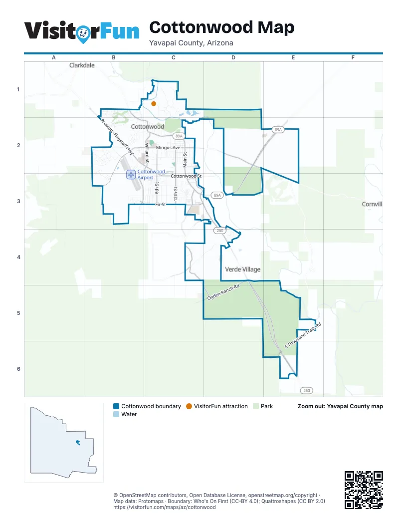
Street index of Cottonwood
Each street on the sheet and the grid squares it crosses.
- Prescott–Flagstaff HighwayB2, C2, D2, E2, C3, D3
- Camp Verde–Bridgeport HighwayC3, D3, D4, D5, E5, E6
- South Main StreetC2, C3
- East Cottonwood StreetB3, C3
- State Route 89AD2
- Prescott-Flagstaff HighwayB2
- Cottonwood–Camp Verde–Mogollon Rim HighwayE6
- North Main StreetB1, B2, C2
- West Mingus AvenueB2, C2, B3
- Mingus AvenueD2, B3
- East Mingus AvenueC2
- East Cornville RoadD2
- Old Highway 279C4, D5, E6
- South 12th StreetC2, C3
- South 6th StreetC2, C3
- Ogden Ranch RoadD4, D5
- South Willard StreetB2, C2, B3
- East Fir StreetC3
- Camino RealC3
- Cove ParkwayC3
- North Willard StreetC2
- South Monte Tesoro DriveB3
- West Fir StreetB3, C3
- Fir StreetC3
- East Quail Springs RanchRoadC4
- Rio Mesa TrailD3
- Verde DriveC3
- Dead Horse Ranch RoadC1
- East Aspen StreetC2
- East Elm StreetC3
- South 7th StreetC2, C3
- East Quail Springs Ranch RoadC4, D4
- East Cherry StreetC2
- South Airpark RoadB2, B3
- West Black Hills DriveB2
- East Thousand Trails RoadE5, E6
- South 10th StreetC2, C3
- South 8th StreetC3
- Groseta Ranch RoadB1, B2
- North Verde Heights DriveB2, C2
- Black Canyon DriveD5, E5
- South 16th StreetC3
- Mesquite Hills DriveB2, B3
- Roadrunner RoadC1
- South Rocking Chair RoadD2, D3
- East Date StreetC3
- South 15th StreetC2, C3
- El Rio del OroB2
- South 4th StreetC3
- East Coconino StreetC2
- Uvx RoadD3, D4
- Chuckwalla DriveB3
- South 5th StreetC3
- South 14th StreetC2, C3
- Flycatcher RoadC1
- 10th StreetC1, C2
- West Trail Blazer DriveB2
- East Birch StreetC2
- West Mesquite DriveB3, C3
- North 14th StreetC2
- West Wagon Wheel RoadB2
- West Desert Willow DriveB2
- South Desperado DriveB2
- South 13th StreetC2, C3
- North 15th StreetC2
- On The Greens BoulevardB1, B2
- North Organ Pipe StreetB2
- South Cottonwood Ranch RoadB2
- Airport RoadB2
- East Cochise StreetC2
- South 17th StreetC2
- North 16th StreetC2
- South 11th StreetC2
- West Running Iron LaneB2
- South 18th StreetC2
- Kindra Heights RoadB2
- South Candy LaneB2
- South Calvary WayB2, B3
- North Willard RoadB1, B2
- East Ash StreetC2
- 17th StreetC3
- East Goddard RoadD4
- North 10th StreetC2
- Barrington DriveB1
- Forest Service Road 761E2
- North Quail TrailC2
- Hogan DriveB1, B2
- South 3rd StreetC3
- North 12th StreetC2
- East Skyline DriveC3
- Overland TrailB1
- West High Country DriveB2
- North Old Clarkdale HighwayB1, B2
- Grey Fox RidgeB1
- Viejo DriveC3
- Pioneer DriveB3
- Octillo DriveC3
- Fleetwood DriveB1
- Silver Springs CircleC3
- Justin DriveB2
- North Palo Verde StreetB2
- South 16th PlaceC2, C3
- South Grapevine WayE5
- Five Star BoulevardC3
- West Bronco LaneB2
- East Ridgeview DriveC3
- Calle CortaC3
- Chateau DriveB2
- West Cottonwood StreetB3
- West On The Greens BoulevardB1
- Marauder DriveC3
- South Paula StreetC2
- East Apache StreetC2
- Boulder LaneC3
- Pheasant RoadC1
- East Gila StreetC2
- Rocky Knolls RoadC4
- West Graham StreetB2, C2
- Carriage DriveB1
- West Couples DriveB1, B2
- West Whipple DriveB3
- Kerley LaneC2
- Vanderhoef LaneC2
- Coconino StreetC2
- East Ash DriveC2
- Horseshoe Bend CircleB3
- East Pima StreetC2
- Crescent RoadD4
- North 5th StreetC2
- West Ocotillo StreetB2
- North 3rd StreetC2
- East Cottonwood DriveC3
- Gold Rush LaneB2, B3
- East Crestview DriveC3
- North Cactus StreetC2
- North Yucca StreetB2
- North 11th StreetC2
- North 4th StreetC2
- Annas AvenueB2
- Sawmill RoadC2, C3
- Latigo WayB2
- East Beech StreetC2
- East Settlers CircleC3
- East Villa DriveC3
- East Memory LaneC2
- Jay LoopC1
- North 6th StreetC2
- East Cottonwood PlaceC3
- East Tierra Verde DriveB3, C3
- Mariposa DriveC3
- Pine Shadows DriveB1
- Cypress StreetC3
- South 3rd DriveC3
- West Pinal StreetB2, C2
- South Vista Grande DriveC3
- East Pinal StreetC2
- North Apsco LaneB2
- Maverick WayB2
- West First StreetB3
- Summit RoadD4
- North 7th StreetC2
- South Rainbow Ridge DriveD3
- Sawmill CoveC3
- North Bill Grey RoadE2
- Owl RoadC1
- Golddust CircleB2
- South 8th PlaceC2
- South 9th StreetC2
- South Sagebrush WayB2
- Tonopah DriveB3
- South Wild Horse WayB2
- Nomad DriveB1
- Rustler LaneB2
- Jennifer DriveB2
- Canyon DriveB2
- North 1st StreetC2
- South Skyline WayC3
- South Tigres TrailC3
- National CircleB1
- East Graham StreetC2
- West Gila StreetB2
- North 2nd StreetC2
- North Mesquite StreetB2
- Terry CircleB1
- East Greenlee StreetC2
- North Nicklaus DriveB1
- East River Front RoadC2
- Ochoa DriveB3
- Glenbrook StreetB1
- Alamos DriveB2
- Yavapai StreetC2
- Mongini DriveD3
- Allegro DriveB1
- Mingus View DriveD3
- Mabery Ranch RoadC1
- North 8th StreetC2
- Rambler DriveB1
- North Crenshaw AvenueB1
- South 7th PlaceC3
- North Ocotillo StreetB2
- Fuqua StreetB1
- North Balboa StreetC2
- North Willard DriveC2
- North 17th StreetC2
- Glenshire LaneB3
- South 17th PlaceC2, C3
- East Beech CircleC2
- East Cyprus StreetC2
- South 2nd StreetC3
- West Tumbleweed LaneB2
- 17th PlaceC3
- Skyview LaneC3
- West Pima StreetB2, C2
- Beech StreetC2
- Paula CircleC2
- North Nelson PlaceB1
- Tuzigoot VistaC1
- Prairie LaneD4
- Bainbridge StreetB1
- East Parada del SolC3
- Canyon Ridge RoadD4
- Airpark WayB2
- Skyview CircleC3
- Kingfisher RoadC1
- Paradise DriveC3
- West Ash CircleB2
- Oro DriveC3
- Golden Eagle RoadC1
- East Maricopa StreetC2
- Bluff DriveC3
- Paramount StreetC3
- East Mojave StreetC2
- West Roper LaneB2
- East Navajo StreetC2
- Avion StreetB1
- Agna PrietaC3
- Kearny WayB3
- Manzanita DriveC3
- Marlette StreetB1
- Avda Rio VerdeC3
- Palo Santo WayC4
- Vista de MontanaC3
- Cowboy WayB2
- Silver Spur CircleB2
- North 9th StreetC2
- South 10th PlaceC2
- Corazon LaneC3
- Dolphin DriveB1
- Entrada DriveC3
- Sangria DriveB2
- West Trail EndB2
- Mountainside DriveB3
- Spur DriveB3
- Ironwood CircleB3
- West Cedar Post LaneB2
- South 2nd DriveC3
- West Ash PlaceB2
- Crestview CourtC3
- South Cholla StreetB2
- Tonopah WayB3
- South 18th PlaceC2
- South Buckskin CircleB2
- Flamingo StreetB1
- 6th PlaceC2
- Pinion DriveC3
- Raven LoopC1
- South 13th PlaceC3
- Lobo LaneD3
- South Crestview CourtC3
- East Night Hawk DriveD3
- Sierra Madre DriveC3
- East Mira Loma DriveD3
- West Ash DriveB2
- South Sand Flower DriveD3
- Prestige WayB1
- Lobo CircleD3
- Salida LaneC3
- East Aspen PlaceC2
- Frontier StreetB1
- Rainbow DriveC3
- Date StreetC3
- Redman StreetB1
- South Verde StreetB2
- Champion StreetB1
- South Campfire CircleB2
- Sterling LaneB2
- West Dart CircleB2
- West Santa Cruz StreetC2
- Quail LoopC1
- South Filly CircleB2
- East Sonoma CourtD3
- Ridge CircleB3
- Prickly Pear StreetB2
- Woodpecker CircleC1
- Citation WayB1
- Donner TrailC3
- South Bull Dogger CircleB2
- Kindra CourtB2
- South Homestead CircleB2
- South Corral CircleB2
Things to do on the Cottonwood map
Places on the map
- 89 & Vine
- Ace Hardware
- All Souls Cemetery
- American Heritage Academy
- American Legion
- Aspen Mini Storage
- AutoZone
- Belfry
- Black Bear Diner
- Black Mesa Tank
- Blackhawk Loop Campground
- Camelot RV Resort
- Camp Verde–Bridgeport Highway
- Chase
- Circle K
- Cliffrose Loop
- Cooper's Hawk Loop Campground
- Cottonwood Airport
- Cottonwood Cemetery
- Cottonwood Community Garden
- Cottonwood Community School
- Cottonwood Educational Services
- Cottonwood Kid's Park
- Cottonwood Post Office
- Coyote Trails Golf Cours (ex Pine Shadows)
- Dead Horse Ranch State Park
- East Lagoon
- Merkin Vinyards
- Middle Lagoon
- Mingus Union High School
- Ogden Ranch Road
- Oxendale
- Quail Loop Campground
- Red-Tail Hawk Loop Campground
- Riverfront Park
- Verde Baptist Church
- Verde Valley Medical Center
- Walmart Supercenter
- West Lagoon
- West Lagoon Loop Trail
Next to Cottonwood
- Clarkdale
- Cornville
- Verde Village
© OpenStreetMap contributors, Open Database License, openstreetmap.org/copyright · Map data: Protomaps · Boundary: Who's On First (CC-BY 4.0); Quattroshapes (CC BY 2.0)















