

Arizona map
El Mirage map
About 36,468 people live here (Census Bureau, 2024 estimate). The sheet's index lists 253 streets; North Dysart Road, North El Mirage Road and North 125th Avenue cross the most grid squares. Also on it: Pueblo El Mirage Golf Club, BNSF Automotive Distribution Center and Coyote Pass RV & Mini Storage.
Open the map (PDF, US Letter)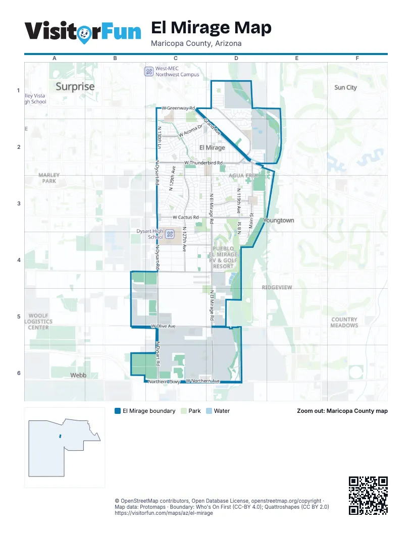
Street index of El Mirage
Each street on the sheet and the grid squares it crosses.
- Canyon RoadC1
- Grand AvenueC1, D2
- Hopi RoadC1
- Main StreetC1
- Navajo RoadC1
- North Cactus LaneC1
- North Dysart RoadC1, C2, C3, C4, C5, C6
- North Fletcher StreetC1
- North Jerry StreetC1
- North Sunny LaneC1
- North Sunrise RoadC1, C2
- North Sunset RoadC1, C2
- Northwest Grand AvenueC1, C2, D2
- Santa Fe DriveC1
- Tonto RoadC1
- West Greenway RoadC1, D1
- West Market StreetC1
- West Sunrise RoadC1
- West Sunset RoadC1
- North A CourtD1
- North A StreetD1, D2, D3
- North Alto StreetD1, D2, D3
- North B CircleD1
- North B CourtD1
- North Caribbean LaneD1
- North El Frio CourtD1
- North El Mirage RoadD1, D2, D3, D4, D5, D6
- North Honcho CourtD1
- North Luna DriveD1, D2
- North Luna StreetD1, D2
- North Main StreetD1, D2, D3, D4
- North Pablo CourtD1
- North Palm StreetD1, D2, D3
- North Poppy StreetD1, D2, D3
- North Tonya StreetD1, D3
- North Verbena StreetD1, D2
- West Acapulco DriveD1, D2
- West Acapulco LaneD1
- West Caribbean LaneD1
- West Desert LaneD1
- West Ironwood StreetD1
- West Maui LaneD1, D2
- West Ocotillo LaneD1
- West Port au Prince LaneD1
- West Saguaro LaneD1
- West Tara LaneD1
- West Thompson Ranch RoadD1, D2
- North 124th AvenueC2, C3
- North 124th DriveC2
- North 124th LaneC2, C3
- North 125th AvenueC2, C3, C4, C5, C6
- North 125th DriveC2, C3
- North 125th LaneC2, C4
- North 126th AvenueC2, C3
- North 126th DriveC2, C3, C4
- North 126th LaneC2, C4
- North 127th AvenueC2, C3, C4
- North 127th DriveC2, C3
- North 127th LaneC2, C3
- North 128th AvenueC2, C3
- North 128th DriveC2, C3
- North 129th AvenueC2, C3, C4
- North 129th DriveC2, C3
- North 130th AvenueC2, C3
- North 130th DriveC2, C3
- North 130th LaneC2, C3
- North 2nd AvenueC2
- North 3rd AvenueC2
- North 4th AvenueC2
- North 5th AvenueC2
- Santa Fe LaneC2, D2
- West Acoma DriveC2, D2
- West Ash StreetC2, D2, C3
- West Boca Raton RoadC2, D2
- West Calavar RoadC2, D2
- West Country Gables DriveC2
- West Crocus DriveC2
- West Evans DriveC2
- West Gelding DriveC2
- West Hearn DriveC2
- West Hearn RoadC2
- West Lisbon LaneC2
- West Mandalay LaneC2
- West Mauna Loa LaneC2, D2
- West Port Royale LaneC2, D2
- West Rainbow RoadC2
- West Redfield RoadC2, D2
- West Saint Moritz LaneC2
- West Santa Fe LaneC2
- West Sharon DriveC2
- West Surrey AvenueC2, C3
- West Thunderbird RoadC2, D2
- West Ventura StreetC2, D2
- West Via CamilleC2
- West Voltaire AvenueC2
- West Waddell RoadC2
- West Well StreetC2, D2
- West Willow AvenueC2
- Casa Mirage ApartmentsD2
- North 115th AvenueD2, D3
- North 115th LaneD2, D3
- North 117th AvenueD2, D3
- North 1st AvenueD2
- North B StreetD2, D3, D4
- North Cesar Chavez DriveD2, D3
- North El Frio CircleD2
- North El Frio StreetD2, D3
- North Fuller DriveD2, D3
- North Olive StreetD2, D3, D4
- North Pablo StreetD2, D3, D4
- North Primrose StreetD2, D3
- North Tanya StreetD2, D3
- North Tonya CircleD2
- Poppy StreetD2
- River RoadD2
- West Banff CourtD2
- West Banff LaneD2
- West End StreetD2
- West M LaneD2
- West Palo Verde RoadD2
- West River RoadD2
- West Soledad StreetD2, C3, D3
- West Surrey StreetD2
- 128th AvenueC3
- 128th DriveC3
- North 123rd LaneC3, D3
- North 125 AvenueC3, C4
- North 128th LaneC3
- North 129th LaneC3
- West Aster DriveC3, D3
- West Aster RoadC3, D3
- West Bloomfield CourtC3
- West Bloomfield RoadC3, D3
- West Cactus RoadC3, D3
- West Canterbury DriveC3, D3, C4
- West Charter Oak RoadC3, D3
- West Cherry Hills DriveC3
- West Columbine CourtC3
- West Columbine DriveC3, D3
- West Corrine DriveC3, D3
- West Dahlia DriveC3, D3
- West Dreyfus DriveC3, D3
- West Flores DriveC3, D3
- West Larkspur RoadC3, D3
- West Laurel LaneC3, D3
- West Myer LaneC3, D3
- West Paradise DriveC3, D3
- West Parque Del Sol BoulevardC3
- West Pershing CourtC3
- West Pershing StreetC3, D3
- West Rosewood DriveC3, D3
- West Rosewood LaneC3
- West Scotts DriveC3, D3
- West Shaw Butte DriveC3, D3
- West Summit WayC3
- West Sunnyside CircleC3
- West Sunnyside DriveC3, D3
- West Sweetwater AvenueC3, D3
- West Valentine AvenueC3, D3
- West Windrose DriveC3, D3
- Bloomfield RoadD3
- North 116th AvenueD3
- North 119th AvenueD3
- North 121st AvenueD3, D4, D5
- North 121st DriveD3
- North 121st LaneD3
- North 122nd AvenueD3
- North 122nd DriveD3
- North 122nd LaneD3
- North 123rd DriveD3
- North Park PlaceD3, D4
- North Reese AvenueD3
- North Tonya DriveD3
- North123rd LaneD3, D4
- West 17th AvenueD3, D4
- West 18th AvenueD3, D4
- West 19th AvenueD3
- West 9th AvenueD3, D4
- West Ester DriveD3
- West Main StreetD3
- West Meyer LaneD3
- West Pastor CourtD3
- West Pershing AvenueD3
- West Poinsettia DriveD3
- West PuebloD3
- West Rancho De Moreno BoulevardD3
- West Scott's DriveD3
- West Valentine StreetD3
- West Wethersfield RoadD3
- West Windrose AvenueD3
- West Berry LaneC4, D4
- West Cameron CircleC4
- West Cameron CourtC4
- West Cameron DriveC4, D4
- West Canterbury CircleC4
- West Desert Cove RoadC4, D4
- West Desert Mirage CircleC4, D4
- West Desert Oasis CircleC4, D4
- West Peoria AvenueC4, D4
- West Rioglass Solar DriveC4
- West Sahuaro DriveC4
- West Sierra CircleC4
- West Sierra StreetC4, D4
- West Varney RoadC4, D4
- West Wolfley DriveC4
- 10th AvenueD4
- 11th AvenueD4
- 8th AvenueD4
- 8th StreetD4
- 9th AvenueD4
- 9th StreetD4
- Iva's CircleD4
- North 1st StreetD4
- North 2nd StreetD4
- North 3rd StreetD4
- South 10th StreetD4
- South 13th StreetD4
- South 14th AvenueD4
- South 1st StreetD4
- South 2nd StreetD4
- South 3rd StreetD4
- South 4th StreetD4
- South 5th StreetD4
- South 6th StreetD4
- South 7th StreetD4
- South 8th StreetD4
- South El Dorado CircleD4
- South Park PlaceD4
- West 11th AvenueD4
- West 12th AvenueD4
- West 13th AvenueD4
- West 1st AvenueD4
- West 2nd AvenueD4
- West 3rd AvenueD4
- West 4th AvenueD4
- West 5th AvenueD4
- West 6th AvenueD4
- West 7th AvenueD4
- West 8th AvenueD4
- West Altadena AvenueD4
- West Cortez StreetD4
- West El Dorado AvenueD4
- West Lupine AvenueD4
- West Varney AvenueD4
- West Joe R Ramirez RoadB5, C5, D5
- West Olive AvenueB5, C5, D5
- West Alice AvenueC5, D5
- West Cinnabar AvenueC5, D5
- Northern ParkwayB6, C6, D6
- West Bulter DriveB6, C6
- West Butler DriveC6, D6
- West Northern AvenueC6, D6
- West Orchid LaneC6
Places on the map
- Arizona Cannabis Society
- Bill Gentry Park
- BNSF Automotive Distribution Center
- Christian Liberty Center
- Church of Christ
- Circle K
- Courys Grand Marketplace
- Coyote Pass RV & Mini Storage
- CubeSmart
- Dollar Tree
- Dysart Elementary School
- Dysart High School
- El Mirage City Hall
- El Mirage Dog Park
- El Mirage Elementary School
- El Mirage Fire Staion 121
- El Mirage Library
- El Mirage Police Department
- El Mirage Post Office
- Eternal Valley Memorial Park
- Family Dollar
- Food City
- Gateway Park
- Gentry Park Baseball Field
- Goodwill
- Grand Auto Plaza
- Lower El Mirage Wash Basin
- Moreno Park
- NAPA Auto Parts
- Parks & Sons Garbage Service
- Pratt's Pets
- Premier RV & Self Storage
- Pueblo El Mirage Golf Club
- Riverview Elementary School
- RV Arizona
- Santa Teresita Catholic Church
- Sunbelt Rentals
- Surprise Elementary School
- Unted States Postal Service El Mirage
- Walmart Supercenter
Next to El Mirage
- Ashton Ranch
- Clubhouse Municipal Square
- Country Meadows
- Marley Park
- Ridgeview
- Sun City
- Surprise map
- Veramonte
- Webb
- Woolf Logistics Center
- Youngtown
© OpenStreetMap contributors, Open Database License, openstreetmap.org/copyright · Map data: Protomaps · Boundary: Who's On First (CC-BY 4.0); Quattroshapes (CC BY 2.0)















