

Arizona map
Flagstaff map
About 77,539 people live here (Census Bureau, 2024 estimate). The sheet's index lists 300 streets; Purple Heart Trail, East Santa Fe Avenue and Arizona Veterans Highway cross the most grid squares. Things to do inside the boundary: Grand Canyon Adventures and Lowell Observatory.
Open the map (PDF, US Letter)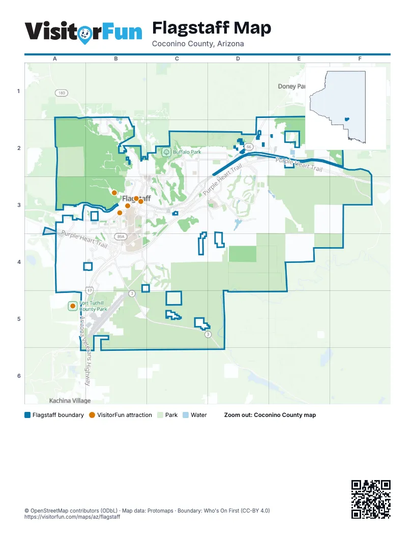
Street index of Flagstaff
Each street on the sheet and the grid squares it crosses.
- Purple Heart TrailD2, E2, F2, A3, C3, D3, F3, A4, B4, C4
- Arizona Veterans HighwayB4, A5, B5, B6
- Flagstaff-Valle HighwayD2
- East Santa Fe AvenueD2, E2, F2, B3, C3, D3, F3
- East Butler AvenueB3, C3, D3
- Flagstaff–Cameron HighwayD1, D2
- North Fort Valley RoadB1, B2, B3
- South Milton RoadB3, B4
- Country Club DriveD2
- South Ponderosa ParkwayC3
- Humphreys StreetB3
- West Santa Fe AvenueB3
- John Wesley Powell BoulevardA5, B5
- Flagstaff–Valle HighwayD2
- West Historic Route 66B3
- Lake Mary RoadB4, B5, C5, D5
- East John Wesley Powell BoulevardB4, C4
- Beulah BoulevardB4, A5, B5
- South Lone Tree RoadB3, C3, B4, C4
- South Beulah BoulevardB3, B4
- East Cedar AvenueC2
- West Forest AvenueB2, C2
- West Forest Meadows StreetB3, B4
- Walnut Canyon RoadF3
- South Lake Mary RoadB4
- North Fourth StreetC2, C3
- West Butler AvenueB3
- West University Heights Drive NorthB4
- North Gemini DriveC2, C3
- South Woodlands Village BoulevardB3, B4
- East Soliere AvenueD2, D3
- South Woody Mountain RoadA3, A4
- East Linda Vista DriveC2, D2
- North Country Club DriveD2, D3
- North Fremont BoulevardB1, A2, B2
- North San Francisco StreetC2, B3, C3
- West University Heights Drive SouthA4, B4
- West High Country TrailB4, B5
- East Zuni DriveB4, C4
- South Pulliam DriveB4, B5
- North 4th StreetC2, C3, D3
- East Industrial DriveD2, C3, D3
- East Huntington DriveD2, C3
- West University AvenueB3, A4, B4
- North Beaver StreetC2, B3, C3
- South San Francisco StreetB3, B4
- North Steves BoulevardD2, D3
- West Kiltie LaneA4
- North West StreetC2, C3
- South Knoles DriveB3, B4
- North Turquoise DriveC2, C3
- East Lockett RoadC2, D2
- East Pine Knoll DriveC3, B4, C4
- North Switzer Canyon DriveC3
- East Ponderosa ParkwayC3
- North Dodge AvenueE2
- South 4th StreetC3, D3, C4, D4
- North Pine Cliff DriveC3
- North Thorpe RoadB3
- East Marketplace DriveD2, E2
- East Empire AvenueD2, E2
- East Cherry AvenueB3, C3
- East Lucky LaneC3
- North Fanning DriveD2
- Fox Lair DriveD3
- North Continental DriveD3
- South Thompson StreetB3
- North Peak View StreetB1, B2
- North Bonito StreetB3
- East McConnell DriveB3, B4
- South Plaza WayB3
- West Riordan RoadB3
- West McConnell DriveB4
- South Yale StreetB3
- East Franklin AvenueB3, C3
- East Sawmill RoadB3, C3
- North Foxglenn StreetD3
- East Birch AvenueB3, C3
- South Beaver StreetB3
- East Arrowhead AvenueC3
- University DriveB3
- East Aspen AvenueB3, C3
- North Test DriveE2
- Pine Knoll DriveB4
- Sparrow AvenueD3
- East Country Club DriveD3
- West University DriveB3
- North Verde StreetB3, C3
- West Navajo RoadB3
- Nestle Purina AvenueD2
- South Mall WayD2
- Hopi DriveB2, B3
- West Columbus AvenueB3, C3
- North Shultz Pass RoadB1
- South Cochise DriveB4
- South Andrea DriveB4
- East Columbus AvenueC3
- East University DriveB3
- West Franklin AvenueB3
- East John Wesley Powell BoulevradD3
- South Clubhouse CircleB4, C4, C5
- East Old Walnut Canyon RoadD3, E3, E4, F4
- Old Walnut Canyon RoadE3, E4, F4
- North Oakmont DriveD2, D3
- North East StreetC2, C3
- North Main StreetC2, C3
- South Highland Mesa RoadA3, B3, B4
- North Fox Hill RoadD3
- South Gillenwater DriveB4
- East Mount Pleasant DriveD3
- North Center StreetC2, C3
- West McAllister Ranch RoadA3
- Forest Service Road 532A4
- Herold Ranch RoadC3
- East Whetstone DriveC3, D3
- North Izabel StreetC2, C3
- East Crest Stone RoadC3, D3
- West Kaibab LaneB3
- North Aztec StreetB2, B3
- Coy DriveB4
- North 1st StreetC2, C3
- West Purple Sage TrailA4, A5, B5
- South Walkup DriveB4
- North Rio de Flag DriveD3
- North Patterson BoulevardC2
- North Skyview StreetD3
- North Navajo DriveB2, B3
- North Cobblestone CircleB2
- North Wakonda StreetD3
- West Lower Coconino AvenueB3
- East 4th AvenueC2, C3
- Constitution BoulevardA4
- South Little DriveB4
- South Shullenbarger DriveB4
- West Mars Hill RoadB3
- West Mission Timber CircleA3, A4
- North 3rd StreetC2, C3
- East Nestle Purina AvenueD2
- South Litzler DriveB4
- North Hemberg DriveD2
- South Alvan Clark BoulevardA3
- North Deer Crossing RoadD3
- South Old Munds HighwayA5, A6, B6
- Troxler CircleB4
- North Leroux StreetB3, C3
- East Broken Rock LoopD2, D3
- County Road 301 BE4
- Blackhawk LaneB2
- County Road 301AE4
- South Cheryl DriveA4, B4
- North Walnut Hills DriveD3, E3
- North King StreetC2
- West Lil Ben TrailB4
- East Appalachian AvenueC2
- North Elk Run StreetD2, D3
- Huntington DriveD2
- North Edgewood StreetD3
- East Del Rae DriveC4, C5
- Elder DriveC2, D2
- East Coburn DriveD3
- East Bear Paw DriveD3
- Inland Shores DriveD3
- North Snowflake DriveD1, D2
- North el Paso Flagstaff RoadE2
- East David DriveC3
- East Meadow Brook DriveD3
- East Matterhorn DriveD2
- South Juniper Point BoulevardC4
- North Jamison BoulevardD2
- North Tindle BoulevardD2
- South Moore CircleB4
- West Pollo CircleA3
- South O'Leary StreetB3
- North Monte Vista DriveC2
- Curling Smoke RoadB2
- Green Mountain DriveD3
- North Paradise RoadC2
- East Abineau Canyon DriveD3, E3
- South Cassandra BoulevardA4
- North Lake Hills DriveD3, D4
- South Yaqui DriveB4
- East Dortha AvenueC2
- North Boldt DriveB1, B2
- East 6th AvenueC2
- East 3rd AvenueC3
- West Cherry AvenueB3
- North Kendrick StreetB3
- North Carefree CircleD3
- North Talkington DriveB2
- South Wild West TrailB4
- North Park DriveD2
- Rain Valley RoadE2
- West Cattle Drive TrailB4
- South Babbitt DriveC3
- East Miller DriveC2, D2
- Mount Dell Access RoadB4
- North Amberwood StreetD3
- West Birch AvenueB3
- West Pico del Monte CircleA3
- North Crescent DriveB2
- East Dale AvenueB3, C3
- West Aspen AvenueB3
- TourmalineC4
- Carol DriveA4, B4
- West Coconino AvenueB3
- West Cooper DriveB2
- North Alta Vista DriveD2
- East Woodland DriveB3, C3
- East Morgan RunC4
- West Adirondack AvenueA3, B3
- South Paseo del FlagB3, C3
- South Riordan Ranch StreetB3
- North Schevene BoulevardD2
- North Peak Point RoadC3
- East 2nd AvenueC3
- South Breton DriveA4
- West Beal RoadB2
- West Weston TrailB4
- North Tam O'Shanter DriveD2, D3
- Anita AvenueB4
- Ardrey CircleB4
- West Fir AvenueB2, C2
- South Railroad Spring BoulevardB3
- East Monroe StreetC4, D4
- West Mountain DriveB1, B2
- West Brenda LoopB2
- West Clay AvenueB3
- East Gandalf LaneD3
- North Kasper AvenueD2
- Meade LaneB2
- South Gamma LoopA3
- North Nordica LoopD3
- South Walapai DriveB4
- East Lewis DriveC2, D2
- South Holland RoadB4
- North WC Riles StreetB3, C3
- West Wilson DriveB2
- North Southern Hills DriveD3
- Frontier RoadB5, C5
- North Loma Vista DriveD2
- North Locust DriveC3
- West Pack Trail DriveB2
- West Shamrell BoulevardB5
- South Leroux StreetB3
- Forestdale RoadC3, D3, D4
- East Sterling LaneB4
- North Walgreens StreetD3
- North Cypress Point DriveD3
- West Cinnabar TrailB4, B5
- Mountain View RoadB3
- North 2nd StreetC2, C3
- South WC Riles StreetB3
- East Abbey RoadD3
- East Cortland BoulevardD2
- North Rockridge RoadB2
- Longview RoadB3
- South Hannah LaneB4
- East Payton WayC3
- West Hogan DriveB2
- North Mountaineer RoadE2
- East Settlers Run RoadD3, E3
- West Juniper AvenueB2, C2
- West Cedar AvenueB2, C2
- East Brannen AvenueB3, C3
- North Kramer StreetB2
- South Pyrite RoadB4, B5
- West Alaska AvenueB3
- West Pine AvenueB2, C2
- East Camille DriveB4
- South Union Pacific StreetA3, B3
- West Phoenix AvenueB3
- East 1st AvenueC3
- South Brannen CircleB3, C3
- North Bertrand StreetC3
- North Christmas Tree LaneD1, D2
- East Castle Hills DriveB4
- North Mariposa RoadD3
- North Jasper DriveC2, C3
- West Parker DriveB4
- Grand View DriveC2
- South Bright Angel TrailB4
- East Railhead AvenueD2, E2
- West Lynette DriveB2
- West Blue Willow RoadB2
- Chisholm TrailB5
- North Fox Run DriveD3
- North Rose StreetC2
- North Running Deer StreetD3
- North Sitgreaves StreetB3
- East Jacamar DriveD2
- North Lone Oak WayD3
- North Rain Tree RoadD3
- North Smokerise DriveD2, E2
- East Spring Meadows CircleD3
- North Kinlani RoadB2, B3
- South Presidio DriveA3
- South Mark LaneB3
- West Elm AvenueB3
- West Ax Handle WayA3, B3, A4
- South Links RoadB4
Things to do on the Flagstaff map
Places on the map
- Arroyo Park
- Aspen Valley Golf Club
- Black Barts RV Park
- Buffalo Park
- Bushmaster Park
- Calvary Cemetery
- Canyon Vista Campground
- Cherry Hill
- Cheshire
- Citizen's Cemetery
- Coconino County Jail
- Continental Country Club
- Continental Park
- Coyote Springs
- Flagstaff City Hall
- Flagstaff City Reservoirs
- Flagstaff Mall
- Flagstaff Medical Center
- Flagstaff Pulliam Airport
- Foxglenn Park
- Green Tree Shopping Center
- Humphrey Lake
- Julie Golden Stables
- Kit Carson RV Park
- KOA Holiday - Flagstaff
- Lake Elaine
- Little America Hotel
- Lowell Observatory
- Lynwood
- McPherson Park
- Northern Arizona University
- Pine Canyon Golf Course
- Rehabilitation Hospital Of Northern Arizona
- Sinagua Middle School
- The Guidance Center
- The Marketplace At Flagstaff
- Thorpe Disc Golf Park
- University Plaza
- Valley Crest
Next to Flagstaff
- Doney Park
- Kachina Village
© OpenStreetMap contributors, Open Database License, openstreetmap.org/copyright · Map data: Protomaps · Boundary: Who's On First (CC-BY 4.0); Quattroshapes (CC BY 2.0)