

Arizona map
Northern Arizona map
The sheet's index lists 7 highways; I-40, US 180 and I-17 cross the most grid squares. Things to do inside the boundary: Antelope Canyon Tours, Arizona Snowbowl and Bearizona Wildlife Park. Also on it: Chinle, Eagar and Flagstaff.
Open the map (PDF, US Letter)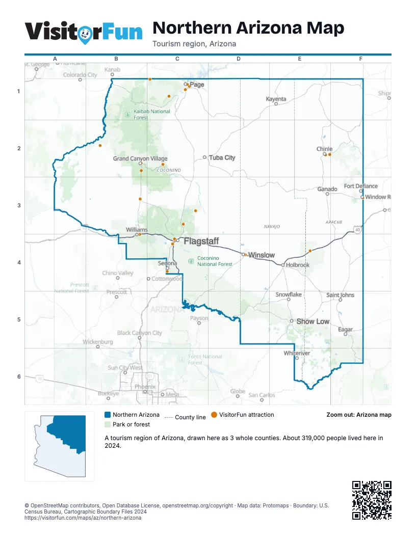
Highway index of Northern Arizona
Each highway on the sheet and the grid squares it crosses.
- I-17C4
- I-40B3, B4, C4, D4, E4, F3, F4
- US 180C4, D4, E4
- US 191F4
- AZ 77E4
- AZ 89AC4
- AZ 99D4
Things to do on the Northern Arizona map
- Antelope Canyon Tours
- Arizona Snowbowl
- Bearizona Wildlife Park
- Canyon Coaster Adventure Park
- Canyon de Chelly National Monument
- Canyon De Chelly Tours
- Chapel of the Holy Cross
- Desert View Watchtower
- El Tovar Hotel
- Flagstaff Extreme Adventure Course
- Glen Canyon National Recreation Area
- Grand Canyon Adventures
- Grand Canyon National Park
- Grand Canyon Railway
- Grand Canyon UTV Tours
- Grand Canyon Visitor Center IMAX
- Havasu Falls
- Horseshoe Bend
- Lake Powell
- Lowell Observatory
- Meteor Crater
- Navajo Zoo
- Papillon Grand Canyon Helicopters
- Petrified Forest National Park
- Raptor Ranch
- Sedona Red Rock Tours
- Skydive the Grand Canyon
- Standin' on the Corner Park
- Sunset Crater Volcano National Monument
- The Wave
- Vermilion Cliffs National Monument
- Waterhole Canyon Experience
- Williams Visitor Center
- Wupatki National Monument
Places on the map
- Chinle
- Eagar
- Flagstaff
- Fort Defiance
- Ganado
- Grand Canyon Village
- Holbrook
- Kayenta
- Page
- Saint Johns
- Sedona
- Show Low
- Snowflake
- Tuba City
- Whiteriver
- Williams
- Window Rock
- Winslow
Next to Northern Arizona
- North Central Arizona map
- Tucson and Southern Arizona
- West Coast Arizona map
- Mountains & Mesas
- Northwest New Mexico
- Southwest New Mexico
- Canyon Country
© OpenStreetMap contributors, Open Database License, openstreetmap.org/copyright · Map data: Protomaps · Boundary: U.S. Census Bureau, Cartographic Boundary Files 2024