

Arizona map
Scottsdale map
About 246,170 people live here (Census Bureau, 2024 estimate). The sheet's index lists 49 streets; North Pima Road, North Scottsdale Road and North Hayden Road cross the most grid squares. Things to do inside the boundary: Discover Salt River Visitor Center, MacDonald's Ranch and OdySea Aquarium.
Open the map (PDF, US Letter)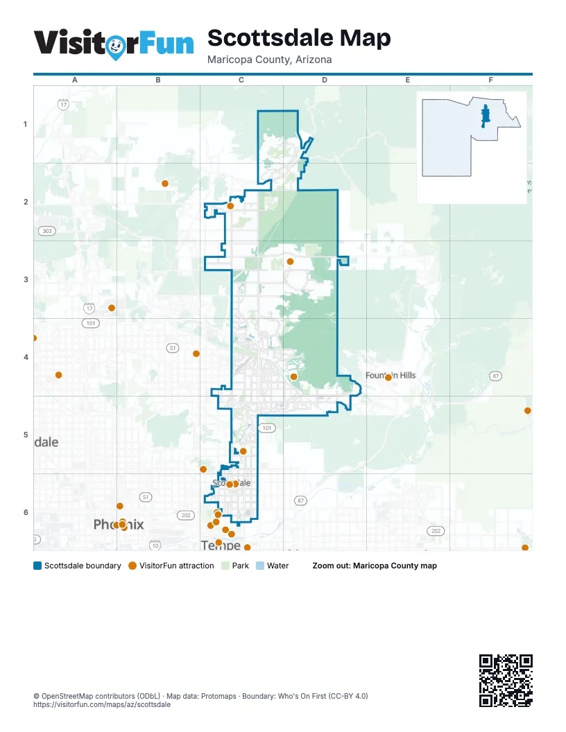
Street index of Scottsdale
Each street on the sheet and the grid squares it crosses.
- Bartlett Dam Road [FR 205]D1
- North Cave Creek RoadD1, D2
- East Carefree HighwayC2
- East Cave Creek RoadC2, D2
- North Pima RoadC2, C3, C4, C5, C6
- North Scottsdale RoadC2, C3, C4, C5, C6
- North Tom Darlington DriveC2
- East Pinnacle Peak RoadC3
- East Thompson Peak ParkwayC3, C4
- North Hayden RoadC3, C4, C5, C6
- North Miller RoadC3
- East Bell RoadC4
- East Cactus RoadC4, D4
- East Frank Lloyd Wright BoulevardC4
- East Greenway ParkwayC4
- East Kierland BoulevardC4
- East Mayo BoulevardC4
- East Princess DriveC4
- East Redfield RoadC4
- East Thunderbird RoadC4
- Frank Lloyd Wright BoulevardC4
- North 92nd StreetC4, C5
- North 94th StreetC4
- North Frank Lloyd Wright BoulevardC4, D4, D5
- North Greenway Hayden LoopC4
- North Thompson Peak ParkwayC4
- Pima FreewayC4, C5
- East Chaparral RoadC5
- East Doubletree Ranch RoadC5
- East Highland AvenueC5, C6
- East Indian Bend RoadC5
- East Lincoln DriveC5
- East McCormick ParkwayC5
- East McDonald DriveC5
- East Mountain View RoadC5
- East Shea BoulevardC5, D5
- East Via De VenturaC5
- North 64th StreetC5, C6
- North Goldwater BoulevardC5, C6
- North Invergordon RoadC5
- East Camelback RoadC6
- East Indian School RoadC6
- East McDowell RoadC6
- East McKellips RoadC6
- East Osborn RoadC6
- East Thomas RoadC6
- North 68th StreetC6
- North Drinkwater BoulevardC6
- North Galvin ParkwayC6
Things to do on the Scottsdale map
Places on the map
- 5th Avenue Shops and Boutiques
- Alterra
- Ancala Country Club
- Ancala Village
- Apache Peak
- Arizona Silverado
- Arrowhead
- ASM International
- Banner Health
- Bellasera
- Bent Tree Desert Estates
- Boulder Crest
- Buenavante
- Cactus Shadows High School
- Camelback Walk
- Canyon Heights
- Carino Canyon
- Cavasson
- Chaparral Park
- Chiricahua Villas
- Cholla Mtn Loop Trail
- Cintarosa Ranch
- City of Phoenix Water Supply
- Cochise Elementary School
- Cochise Ridge
- Copper Ridge Elementary School
- Coronado Golf Course
- Crosscut Canal Path
- Deer Run
- Desert Crown
- Desert Highlands Golf Club
- Desert Mountain Apache Golf Course
- Desert Mountain Chiricahua Golf Course
- Desert Mountain Cochise Golf Course
- Desert Mountain Geronimo Golf Course
- Desert Mountain High School
- Desert Mountain Outlaw Golf Course
- Desert Mountain Renegade Golf Course
- Desert Vista
Next to Scottsdale
- Fountain Hills
- Phoenix map
- Tempe
© OpenStreetMap contributors (ODbL) · Map data: Protomaps · Boundary: Who's On First (CC-BY 4.0)